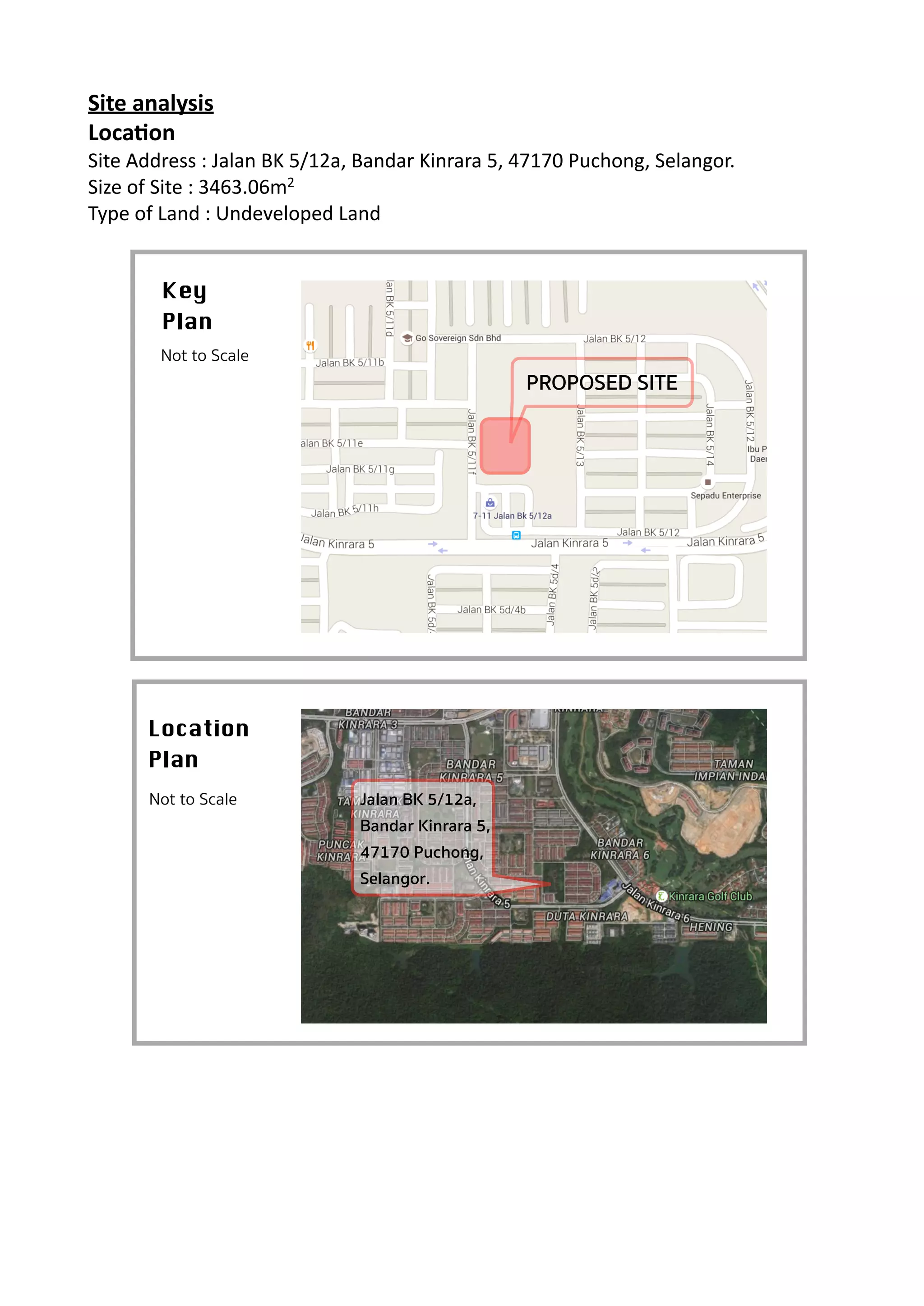
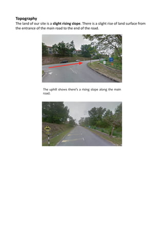
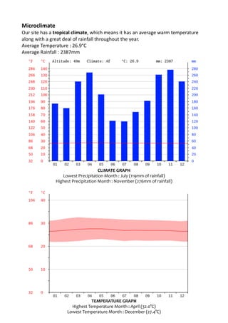
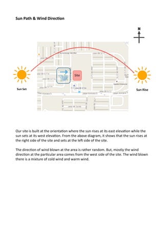
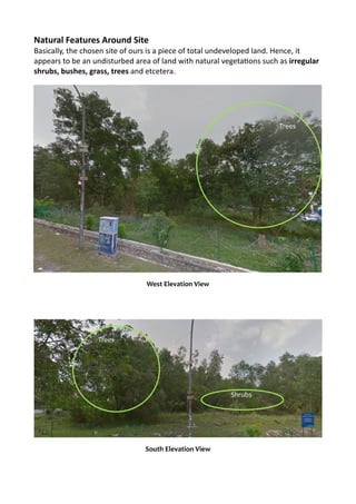
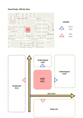
Site	
  analysis	
  
Loca.on	
  
Site	
  Address	
  :	
  Jalan	
  BK	
  5/12a,	
  Bandar	
  Kinrara	
  5,	
  47170	
  Puchong,	
  Selangor.	
  
Size	
  of	
  Site	
  :	
  3463.06m2	
  
Type	
  of	
  Land	
  :	
  Undeveloped	
  Land	


Key 

Plan
Not to Scale
PROPOSED SITE
Location 

Plan
Not to Scale Jalan BK 5/12a,
Bandar Kinrara 5,
47170 Puchong,
Selangor.
Topography	
  
The	
  land	
  of	
  our	
  site	
  is	
  a	
  slight	
  rising	
  slope.	
  There	
  is	
  a	
  slight	
  rise	
  of	
  land	
  surface	
  from	
  
the	
  entrance	
  of	
  the	
  main	
  road	
  to	
  the	
  end	
  of	
  the	
  road.	


A	
  slight	
  rising	
  slope	
  can	
  be	
  observed	
  from	
  the	
  side	
  road.
The	
  uphill	
  shows	
  there’s	
  a	
  rising	
  slope	
  along	
  the	
  main	
  
road.
Microclimate	
  
Our	
  site	
  has	
  a	
  tropical	
  climate,	
  which	
  means	
  it	
  has	
  an	
  average	
  warm	
  temperature	
  
along	
  with	
  a	
  great	
  deal	
  of	
  rainfall	
  throughout	
  the	
  year.	
  
Average	
  Temperature	
  :	
  26.9°C	
  
Average	
  Rainfall	
  :	
  2387mm	
  
The	
  driest	
  month	
  is	
  July,	
  with	
  119	
  mm	
  of	
  rainfall.	
  The	
  greatest	
  amount	
  of	
  
precipitaRon	
  occurs	
  in	
  November,	
  with	
  an	
  average	
  of	
  276	
  mm.	


CLIMATE	
  GRAPH	
  
Lowest	
  Precipitation	
  Month	
  :	
  July	
  (119mm	
  of	
  rainfall)	
  
Highest	
  Precipitation	
  Month	
  :	
  November	
  (276mm	
  of	
  rainfall)	
  
TEMPERATURE	
  GRAPH	
  
Highest	
  Temperature	
  Month	
  :	
  April	
  (32.0°C)	
  
Lowest	
  Temperature	
  Month	
  :	
  December	
  (27.4°C)
Sun	
  Path	
  &	
  Wind	
  Direc.on	
  
Our	
  site	
  is	
  built	
  at	
  the	
  orientaRon	
  where	
  the	
  sun	
  rises	
  at	
  its	
  east	
  elevaRon	
  while	
  the	
  
sun	
  sets	
  at	
  its	
  west	
  elevaRon.	
  From	
  the	
  above	
  diagram,	
  it	
  shows	
  that	
  the	
  sun	
  rises	
  at	
  
the	
  right	
  side	
  of	
  the	
  site	
  and	
  sets	
  at	
  the	
  leV	
  side	
  of	
  the	
  site.	
  	
  
The	
  direcRon	
  of	
  wind	
  blown	
  at	
  the	
  area	
  is	
  rather	
  random.	
  But,	
  mostly	
  the	
  wind	
  
direcRon	
  at	
  the	
  parRcular	
  area	
  comes	
  from	
  the	
  west	
  side	
  of	
  the	
  site.	
  The	
  wind	
  blown	
  
there	
  is	
  a	
  mixture	
  of	
  cold	
  wind	
  and	
  warm	
  wind.	


N
Sun	
  Set	
   Sun	
  Rise	
  
Site
Natural	
  Features	
  Around	
  Site	
  
Basically,	
  the	
  chosen	
  site	
  of	
  ours	
  is	
  a	
  piece	
  of	
  total	
  undeveloped	
  land.	
  Hence,	
  it	
  
appears	
  to	
  be	
  an	
  undisturbed	
  area	
  of	
  land	
  with	
  natural	
  vegetaRons	
  such	
  as	
  irregular	
  
shrubs,	
  bushes,	
  grass,	
  trees	
  and	
  etcetera.	


West	
  Elevation	
  View
South	
  Elevation	
  View
Trees
Shrubs
Trees
Visual	
  Study	
  :	
  Off-­‐site	
  View	


Site
OUR	
  
SITE
Main	
  Road
Undeveloped	
  
Land
Undeveloped	
  
Land
Shop	
  Lots
Residential	
  
Area
LEGEND	
  
Good
View
Bad
View
ICI Site Analysis PDF

ICI Site Analysis PDF

  • 1.
    Site  analysis   Loca.on   Site  Address  :  Jalan  BK  5/12a,  Bandar  Kinrara  5,  47170  Puchong,  Selangor.   Size  of  Site  :  3463.06m2   Type  of  Land  :  Undeveloped  Land           Key Plan Not to Scale PROPOSED SITE Location Plan Not to Scale Jalan BK 5/12a, Bandar Kinrara 5, 47170 Puchong, Selangor.
  • 2.
    Topography   The  land  of  our  site  is  a  slight  rising  slope.  There  is  a  slight  rise  of  land  surface  from   the  entrance  of  the  main  road  to  the  end  of  the  road.           A  slight  rising  slope  can  be  observed  from  the  side  road. The  uphill  shows  there’s  a  rising  slope  along  the  main   road.
  • 3.
    Microclimate   Our  site  has  a  tropical  climate,  which  means  it  has  an  average  warm  temperature   along  with  a  great  deal  of  rainfall  throughout  the  year.   Average  Temperature  :  26.9°C   Average  Rainfall  :  2387mm   The  driest  month  is  July,  with  119  mm  of  rainfall.  The  greatest  amount  of   precipitaRon  occurs  in  November,  with  an  average  of  276  mm.         CLIMATE  GRAPH   Lowest  Precipitation  Month  :  July  (119mm  of  rainfall)   Highest  Precipitation  Month  :  November  (276mm  of  rainfall)   TEMPERATURE  GRAPH   Highest  Temperature  Month  :  April  (32.0°C)   Lowest  Temperature  Month  :  December  (27.4°C)
  • 4.
    Sun  Path  &  Wind  Direc.on   Our  site  is  built  at  the  orientaRon  where  the  sun  rises  at  its  east  elevaRon  while  the   sun  sets  at  its  west  elevaRon.  From  the  above  diagram,  it  shows  that  the  sun  rises  at   the  right  side  of  the  site  and  sets  at  the  leV  side  of  the  site.     The  direcRon  of  wind  blown  at  the  area  is  rather  random.  But,  mostly  the  wind   direcRon  at  the  parRcular  area  comes  from  the  west  side  of  the  site.  The  wind  blown   there  is  a  mixture  of  cold  wind  and  warm  wind.         N Sun  Set   Sun  Rise   Site
  • 5.
    Natural  Features  Around  Site   Basically,  the  chosen  site  of  ours  is  a  piece  of  total  undeveloped  land.  Hence,  it   appears  to  be  an  undisturbed  area  of  land  with  natural  vegetaRons  such  as  irregular   shrubs,  bushes,  grass,  trees  and  etcetera.                     West  Elevation  View South  Elevation  View Trees Shrubs Trees
  • 6.
    Visual  Study  :  Off-­‐site  View                         Site OUR   SITE Main  Road Undeveloped   Land Undeveloped   Land Shop  Lots Residential   Area LEGEND   Good View Bad View