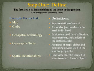
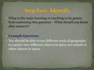
6 Steps to dissecting, understanding and answering a 
research question.
 You have been given a research question or you have 
written one of your own – now what? 
 Example Question: 
 How do maps, globes, geospatial technologies, and 
other geographic tools help humans understand 
spatial relationships?
Example Terms List: 
 Map 
 Globe 
 Geospatial technology 
 Geographic Tools 
 Spatial Relationships 
 Definitions: 
 Representation of an area 
 A round object on which a the 
earth is displayed 
 Equipment used in visualization, 
measurement, and analysis of 
the earths features 
 Are types of maps, globes and 
measuring devices used in the 
study of geography 
 How some object is located in 
space to some reference object
 What is the main learning or teaching to be gotten 
from answering this question – What should you know 
after research? 
 Example Question: 
 You should be able to use different tools of geography 
to explain how different objects in space are related to 
other objects in space.
 Use the terms to write smaller questions 
 Example: 
1. How does a map help me understand where things 
are located in space in reference to other things? 
2. How does a globe help me understand where things 
are located in space in reference to other things? 
3. How does GPS help me understand where things are 
located in space in reference to other things?
 Find the answers to each of the smaller questions. 
 Example: How does a map help me understand where 
things are located in space in reference to other things? 
 A map gives a picture of land, it uses coordinates to offer 
exact location of objects on earth. A map can offer me a 
smaller view of where things are located in relation to other 
things depending on how far I zoom or what I am looking 
at. They can show me animal habitats, cities, desserts, 
mountains, and political boundaries.
 Look at what you need to know when done with the 
research – does your answer help you understand or 
provide an example to demonstrate your idea? 
 In the example: 
 Of how maps help me understand spatial relationships 
I think my research gave me some good examples.
 Answer the question in your own words using your 
research to support the ideas you present in your 
answer. 
 Example:

How to break down a research question

  • 1.
    6 Steps todissecting, understanding and answering a research question.
  • 2.
     You havebeen given a research question or you have written one of your own – now what?  Example Question:  How do maps, globes, geospatial technologies, and other geographic tools help humans understand spatial relationships?
  • 3.
    Example Terms List:  Map  Globe  Geospatial technology  Geographic Tools  Spatial Relationships  Definitions:  Representation of an area  A round object on which a the earth is displayed  Equipment used in visualization, measurement, and analysis of the earths features  Are types of maps, globes and measuring devices used in the study of geography  How some object is located in space to some reference object
  • 4.
     What isthe main learning or teaching to be gotten from answering this question – What should you know after research?  Example Question:  You should be able to use different tools of geography to explain how different objects in space are related to other objects in space.
  • 5.
     Use theterms to write smaller questions  Example: 1. How does a map help me understand where things are located in space in reference to other things? 2. How does a globe help me understand where things are located in space in reference to other things? 3. How does GPS help me understand where things are located in space in reference to other things?
  • 6.
     Find theanswers to each of the smaller questions.  Example: How does a map help me understand where things are located in space in reference to other things?  A map gives a picture of land, it uses coordinates to offer exact location of objects on earth. A map can offer me a smaller view of where things are located in relation to other things depending on how far I zoom or what I am looking at. They can show me animal habitats, cities, desserts, mountains, and political boundaries.
  • 7.
     Look atwhat you need to know when done with the research – does your answer help you understand or provide an example to demonstrate your idea?  In the example:  Of how maps help me understand spatial relationships I think my research gave me some good examples.
  • 8.
     Answer thequestion in your own words using your research to support the ideas you present in your answer.  Example: