Gunbower Forest Environmental Watering Field Trip
•
1 like•923 views

This booklet is designed to act as a resource booklet for a field trip into the Gunbower forest, however, it should also be useful for schools studying environmental watering and wetlands in other areas. I have also uploaded a second booklet, a field work booklet, which contains student tasks. Not working properly? Try this link: https://drive.google.com/file/d/0B11DeM9q7KJCaF9mMDFwWUF2NTg/edit?usp=sharing

Recommended
Recommended
More Related Content
Similar to Gunbower Forest Environmental Watering Field Trip
Similar to Gunbower Forest Environmental Watering Field Trip (20)
Recently uploaded
Recently uploaded (20)
Gunbower Forest Environmental Watering Field Trip
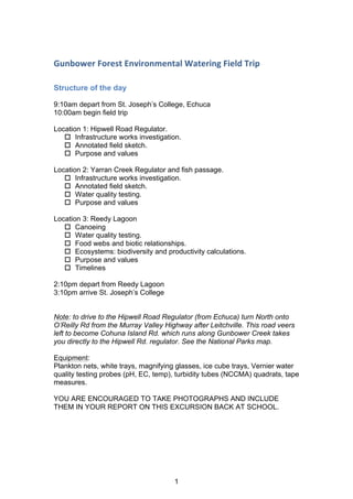
- 1. Gunbower Forest Environmental Watering Field Trip Structure of the day 9:10am depart from St. Joseph’s College, Echuca 10:00am begin field trip Location 1: Hipwell Road Regulator. o Infrastructure works investigation. o Annotated field sketch. o Purpose and values Location 2: Yarran Creek Regulator and fish passage. o Infrastructure works investigation. o Annotated field sketch. o Water quality testing. o Purpose and values Location 3: Reedy Lagoon o Canoeing o Water quality testing. o Food webs and biotic relationships. o Ecosystems: biodiversity and productivity calculations. o Purpose and values o Timelines 2:10pm depart from Reedy Lagoon 3:10pm arrive St. Joseph’s College Note: to drive to the Hipwell Road Regulator (from Echuca) turn North onto O’Reilly Rd from the Murray Valley Highway after Leitchville. This road veers left to become Cohuna Island Rd. which runs along Gunbower Creek takes you directly to the Hipwell Rd. regulator. See the National Parks map. Equipment: Plankton nets, white trays, magnifying glasses, ice cube trays, Vernier water quality testing probes (pH, EC, temp), turbidity tubes (NCCMA) quadrats, tape measures. YOU ARE ENCOURAGED TO TAKE PHOTOGRAPHS AND INCLUDE THEM IN YOUR REPORT ON THIS EXCURSION BACK AT SCHOOL. 1
- 2. Activities Infrastructure works investigation How does water move through the forest and where does it come from? Map: draw a simple map showing the pathway water used in environmental watering takes from Torrumbarry Weir till it re-enters the Murray River. Include a field sketch of one piece of infrastructure. Annotate your sketch to show the height difference between the height of water at Torrumbarry Weir and where it re-enters the Murray. How much water is used in environmental watering? Find out the total volume of water used and returned to the river in the environmental watering. Find out what percentage of water used returns to the river? Why do we have river regulation and what effect does it have on the environment? (Refer to resource booklet graph on p…). Environmental watering is controlled by humans, how does it compare to the timing and duration of floods that have been happening since the river has been regulated? What time of the year does the river flood without regulation? 2
- 3. Fisheries management Find out what effect environmental watering can have on fish breeding (especially Murray cod and European carp)? Blackwater Blackwater: what is it and when does it happen? Is black water always harmful to fish and the river ecosystem? Under what conditions is black water low in oxygen? Under what conditions is black water high in oxygen? What can be done to ensure that a harmful black water event is not caused? 3
- 4. Student worksheet 4.2 cont. 6FLHQWLVWVEHOLHYHWKDWÀRRGVDUHLPSRUWDQWIRUQDWLYH¿VKVSHFLHV:KHQÀRRGLQJRFFXUV¿VKDUHDEOH WRPRYHEHWZHHQWKHULYHUFKDQQHODQGWKHÀRRGSODLQ7KHÀRRGSODLQVDQGWKHFRQQHFWHGZHWODQGV SURYLGHDQXUVHUIRU¿VKKDWFKOLQJV :KDWLVWKHHIIHFWRQ¿VKSRSXODWLRQVLIÀRZVDUHFRQWUROOHGDQGÀRRGLQJLVSUHYHQWHG Explain your answer. 7 Scientists made an interesting observation at weirs such as the one at Torrumbarry: 7KDWZKHQFRQIURQWHGEDGRZQVWUHDPEDUULHUPRUHWKDQSHUFHQWRIWKH¿VKZHUHUHOXFWDQW to pass downstream over or through barriers. 'HVFULEHWKHLPSOLFDWLRQVIRUSRSXODWLRQVRI¿VKVSHFLHVRIZHLUVLQWKH0XUUD'DUOLQJ%DVLQVXFK as the Torrumbarry Weir shown in this photograph. Torrumbarry Weir facing downstream 93 | The Murray-Darling Basin Balancing the priorities of agriculture and the environment © Discover Murray River, www.MurrayRiver.com.au Fish movements study: Murray River 4
- 5. Student worksheet 4.2 Fish movements study: Murray River 6FLHQWLVWVVWXGLQJIUHVKZDWHU¿VKPRYHPHQWVLQWKH0XUUD5LYHULQIRXQGWKDWJHQHUDOO WKHIUHVKZDWHU¿VKLQKDELWHGDVHFWLRQRIULYHUZLWKLQDUDQJHRI±NLORPHWUHV $WFHUWDLQWLPHVGXULQJWKHHDUKRZHYHUPDQ¿VKVSHFLHVVXFKDVJROGHQSHUFKDQDWLYH¿VK species, migrate large distances at times more than 60–80 kilometres downstream of their usual range. /LVWWKUHHUHDVRQVWKDW¿VKZRXOGPRYHXSVWUHDPRUGRZQVWUHDPIURPWKHLUXVXDOUDQJH a) . . . . . . . . . . . . . . . . . . . . . . . . . . . . . . . . . . . . . . . . . . . . . . . . . . . . . . . . . . . . . . . . . . . . . . . . . . . . . . . . . . . . . . . . . . . . . . . . . . . . . . . . . . . . . . . . . . . . . . . . . . . . . . . . . . . . . . . . . . . . . . . . . . . . . . . . . . . . . . . b) . . . . . . . . . . . . . . . . . . . . . . . . . . . . . . . . . . . . . . . . . . . . . . . . . . . . . . . . . . . . . . . . . . . . . . . . . . . . . . . . . . . . . . . . . . . . . . . . . . . . . . . . . . . . . . . . . . . . . . . . . . . . . . . . . . . . . . . . . . . . . . . . . . . . . . . . . . . . . . . c) . . . . . . . . . . . . . . . . . . . . . . . . . . . . . . . . . . . . . . . . . . . . . . . . . . . . . . . . . . . . . . . . . . . . . . . . . . . . . . . . . . . . . . . . . . . . . . . . . . . . . . . . . . . . . . . . . . . . . . . . . . . . . . . . . . . . . . . . . . . . . . . . . . . . . . . . . . . . . . . 2 Analyse Graph AIRUQDWLYHDQGLQWURGXFHG¿VKPRYHPHQWVDWDORFDWLRQRQWKH0XUUD5LYHU 7KHGDWDVKRZVWKHPRYHPHQWRI¿VKDVDVHDVRQDOSHUFHQWDJH 'HVFULEHGLIIHUHQFHVLQ¿VKPRYHPHQWVIRUWKHIRXUVHDVRQV . . . . . . . . . . . . . . . . . . . . . . . . . . . . . . . . . . . . . . . . . . . . . . . . . . . . . . . . . . . . . . . . . . . . . . . . . . . . . . . . . . . . . . . . . . . . . . . . . . . . . . . . . . . . . . . . . . . . . . . . . . . . . . . . . . . . . . . . . . . . . . . . . . . . . . . . . . . . . . . . . . . . . . . . . . . . . . . . . . . . . . . . . . . . . . . . . . . . . . . . . . . . . . . . . . . . . . . . . . . . . . . . . . . . . . . . . . . . . . . . . . . . . . . . . . . . . . . . . . . . . . . . . . . . . . . . . . . . . . . . . . . . . . . . . . . . . . . . . . . . . . . . . . . . . . . . . . . . . . . . . . . . . . . . . . . . . . . . . . . . . . . . . . . . . . . . . . . . . . . . . . . . . . . . . . . . . . . . . . © O’Connor et al 60 50 40 30 20 10 0 89 | The Murray-Darling Basin Balancing the priorities of agriculture and the environment % Seasonal movement Season Natives Introduced summer autumn winter spring *UDSK$6WDQGDUGLVHGSHUFHQWDJHVHDVRQDOGRZQVWUHDPPRYHPHQWIRUQDWLYHDQGLQWURGXFHG¿VKDW.HQQHG¶V:HLU 2¶RQQRU-XVWLQ2¶0DKRQ'DPLHQ 2¶0DKRQ-XVWLQ'RZQVWUHDP0RYHPHQWRI$GXOW0XUUD'DUOLQJ)LVK6SHFLHV )LQDO5HSRUWWR$JULFXOWXUH)LVKHULHV )RUHVWU$XVWUDOLD$UWKXU5ODK,QVWLWXWH-XQHSDJH 5
- 6. Water quality testing Chemical / physical tests for water quality: Test for dissolved oxygen, temperature, nutrients, pH, turbidity, salinity. Record and discuss your results. Location 1 Location 2 Air temp Amount of shade Water depth Water flow Water temp pH EC units Dissolved oxygen turbidity Using the table on the following pages determine the water quality of each location. Location 1: ______________ ex good fair poor degraded Location 2: ______________ ex good fair poor degraded 6
- 7. Biological tests for water quality: Catch macro-invertebrates. Record and discuss your results. Following the directions from Stream Watch on how to sample for invertebrates. After ten minutes of capturing and sorting, use the photographs in the resource booklet to identify and count the macro invertebrates that you have captured. Fill in the water bug survey results sheet How would you rate the health of the locations tested? Biological test of water quality. Yarran regulator Reedy Lagoon Suggests toxic pollution or poor habitat Suggests pollution Suggests high salinity or nutrient levels Suggests good habitat and water quality Suggests toxic pollution or poor habitat Suggests pollution Suggests high salinity or nutrient levels Suggests good habitat and water quality Comments and observations: How would you rate the biodiversity of this ecosystem? What criteria did you use to decide this? ex good fair poor degraded 7
- 8. iMPORTANT sAMPLE ALL HABITATS IN THE CREEK TO OBTAIN THE MAXIMUM BIODIVERSITY OF BUGS LIVING IN THE CREEK. iF PRESENT, HABITATS SAMPLED SHOULD INCLUDE: • EDGE VEGETATION (PLANTS EMERGING FROM THE WATER) PLACE THE NET IN THE WATER AND DRAG IT VIGOROUSLY TOWARDS THE BANK. • RIFFLE ZONES (SHALLOW WATER FLOWING QUICKLY OVER ROCKS) PLACE THE NET DOWNSTREAM, LIFT ROCKS AND LOGS IN THE WATER SO THE BUGS FLOW INTO THE NET. • LARGE ROCKS AND LOGS iF POSSIBLE, LIFT ROCKS AND LOGS OR RUN THE NET UNDER AND AROUND THE ROCKS AND LOGS WITHIN THE WATER. • PLANTS LIVING UNDER THE WATER ffIGOROUSLY RUN THE NET THROUGH THE PLANTS. • POOLS rUN THE NET THROUGH THE SURFACE, MIDDLE AND BOTTOM OF THE WATER COLUMN. 3| USING THE SCOOPING SIEVES AND LARGE SCOOPING NET, COLLECT AS MANY AQUATIC MACROINVERTEBRATES AS POSSIBLE IN 10 MINUTES AND PLACE THEM IN THE SORTING TRAYS. aLTERNATIVELY MACROINVERTEBRATES MAY BE PLACED DIRECTLY INTO A BUCKET CONTAINING CREEK WATER AND THEN TRANSFERRED CAREFULLY INTO SORTING TRAYS FOR SORTING AFTER SAMPLING IS FINISHED. iMPORTANT fiHILST SAMPLING WILL NEED TO BE QUITE VIGOROUS TO OBTAIN THE BEST RESULTS, TRY TO MINIMISE THE IMPACT ON THE CREEK. iF ROCKS, LOGS OR PLANTS ARE MOVED BE SURE TO RETURN THEM TO THEIR ORIGINAL POSITION. aQUATIC MACROINVERTEBRATES PAGE | 3 8
- 9. WATERBUG SURVEY Results Sheet Chessman SIGNAL 2 Stream Pollution Index Stream Quality Rating Calculation Table USE THIS VERSION ONLY FOR: Alcove/edgewater habitat Murray Darling basin above 400 m elevation; coastal basins of Victoria and NSW; Tasmania 10m of EDGE HABITAT Group Name: Group Size: Survey Site: Date Sampled: Step 1: Enter the number of specimens (i.e. how many) of each bug found in column 1 Weight table Step 2: Refer to the weight table for the correct weight factor for the number found column 1 column 2 Step 3: Enter the correct weight factor for each bug in column 2 No of bug type Weight factor Step 4: Multiply the weight factor (column 2) by the bug grade (column 3) and enter the answer in column 4 1 – 2 1 1 Step 5: Add up column 2 (weight factors) 3 – 5 2 Step 6: Add up column 4 (bug value x weight factor) 6 – 10 3 Step 7: Divide total column 4 by total column 2 to calculate your SIGNAL score 11 – 20 4 Step 8: Add up the total number of bug types you found (NOT specimens) 20 5 Step 9: Use the interpretation chart to get an indication of the likely condition of your sampling area WATER BUG TYPE Column 1 No of specimens Column 2 Weight factor Column 3 Bug grade Column 4 Weight factor x bug grade Very sensitive to most pollutants Stonefly nymph 10 Mayfly nymph 9 Alder fly larva 8 Caddis fly larva 8 Sensitive to most pollutants Horsehair worm 6 Water mite 6 Moderately tolerant of most pollutants Beetle or beetle larva 5 Yabby or shrimp 4 Dragonfly or damselfly nymph 3 Fly larva or midge 3 Mussel or clam 3 Nematode 3 Side swimmer 3 Very tolerant of most pollutants Flatworm 2 Freshwater slater 2 Moth caterpillar 2 Segmented worm 2 True bug or true bug nymph 2 Leech 1 Snail 1 TOTALS INTERPRETATION CHART SIGNAL score = total column 4 = ____ = total column 2 SIGNAL score Above 5.5 Suggests toxic pollution or poor habitat Suggests good habitat and water quality Bug types found that are not on list: = Below 5.5 Suggests pollution Suggests high salinity or nutrient levels (may be natural) Total No. of bug types found = 0 - 7 More than 7 Number of bug types Comments/Observations: Air Temp: oC Water Temp: oC Tubidity: NTUs EC/TDS: μS/ppm pH: 9
- 10. Using your results and the rating guidelines below (Streamwatch 1 994), rate the quality of each water sample and record in the table above. 5 4 3 2 Excellent Good Fair Poor Degraded Parameter Note: Number lines are not to scale. Temperature The maximum increase in temperature should not be more than 2°( over a 24 hour period. Conductivity 0 800 1700 2500 10000 ~tS/cm Suitable for drinking Suitable for irrigating Suitable for irrigating Only suitable for Not suitable for irrigation water and irrigation most plants plants with med/ high irrigation of plant with salt tolerance high tolerance of salts pH 0.0 5.0 5.5 6.0 7.0 8.0 -- 8 ;~ 9.0 14.0 Turbidity 0 15.0 17.5 20.0 30.0 N.T.U. Nitrates 0 0.05 0.1 0.2 0.4 mg/L Phosphates 0 0.01 0.06 0.15 0.45 mg/L INTERPRETATION 6. Examine the chemical and biological indicator results. Describe the overall health of the river. 7. Explain why environmental indicators are used to assess the condition of an environment. 8. Describe possible human activities that could contribute to poor water quality along the Werribee River. Printed on 100% recycled paper 5 10
- 11. Purpose values Identify four activities people associate with the Gunbower forest. Choose two groups and their activities which have conflicting needs. How does each value the forest? Group: _ _ _ _ _ _ _ _ _ _ _ _ _ Why they value the forest: Group: _ _ _ _ _ _ _ _ _ _ _ _ _ Why they value the forest: Suggest how the competing needs of interest groups can be realistically be managed? Timelines Make a timeline of human use of the forest beginning with the aborigines and continuing through to the present day. How can we most equitably share the limited amount of water there is in the Murray Darling Basin the 4 million people (and increasing) that directly depend on the river to survive, as well as the natural environment that they depend on and value? 11
- 12. Student worksheet 5.2 3RWHQWLDOVRXUFHVRIFRQÀLFWDPRQJSHRSOHLQWKH0XUUD'DUOLQJ%DVLQ Person Background National Park ranger My role is to conserve the wetlands, which have a strong connection to the health of the river. When the wetlands are operating as they should under natural water levels there is abundant birdlife that FRPHVWRIHHGRQWKHVPDOO¿VKDQGLQVHFWV7KHUHLVDQDPD]LQJ web of life that depends upon getting the suitable levels of water WKDWQRUPDOOKDSSHQLQVSULQJZKHQWKHULYHUÀRRGVLWVEDQNV7KH UHFHQWÀRRGLVWKH¿UVWZHKDYHKDGLQQHDUOWHQHDUV Murrawarri Traditional Owner from western Basin area We have a very strong continued connection to the land. We have taken care of the country since time immemorial. One particular interest right down the Murray-Darling Basin is our Rainbow Serpent; we call it the Mundaguddah. He keeps the rivers healthy. Another part of the land, the red river gum, is our link to our ancestors. Our old people would talk to the ancestors through the leaves of the red river gums growing along the river. If the red river gum dies, our spiritual connection to our ancestors and our Dreaming is lost. That’s our strong cultural connection to the river. Grape grower Our family has been in the grape-growing industry for nearly 50 HDUV:HRZQDYLQHDUGLQ0LOGXUD9LFWRULD:HXVHGWRXVHÀRRG LUULJDWLRQEXWUHDOLVHGZHFRXOGLUULJDWHLQDPRUHHI¿FLHQWZDVRZH moved to drip irrigation, which was very costly to set up. We need a secure water supply to ensure our vines grow and stay alive year after year. Our town relies on the income of the farming community. I, and other farmers, put money into the community. Dairy cattle farmer I appreciate that the environment is important so the critical thing for me is to balance the amount of water I use and be able to supply people the milk they need. Our dairy-farming community supplies milk to the local area as well as the cities. Many businesses rely on our milk for their income – for example, processing, transport, packaging and retail. Grain grower Irrigating our farmland increases our productivity. On our farm we JURZZKHDW,WFRXOGEHZKHDWIURPPIDUPWKDWLVWXUQHGLQWRÀRXU which is used to make the bread, pasta and biscuits that you eat. New technologies help me reduce my water use. It ensures that I water only when the soil moisture is at a certain level. 118 | The Murray-Darling Basin Balancing the priorities of agriculture and the environment 12
- 13. Student worksheet 5.2 cont. 3RWHQWLDOVRXUFHVRIFRQÀLFWDPRQJSHRSOHLQWKH0XUUD'DUOLQJ%DVLQ Person Background Orchardist I grow apples, pears and peaches. I have taken out a large bank ORDQWRUXQPRUFKDUG,W¶VEHHQGLI¿FXOWZLWKWKHUHFHQWGURXJKW I’ve removed a levee bank that stopped my back paddock from ÀRRGLQJVRQRZWKHZHWODQGLVUHFRQQHFWHGWRWKHULYHU7KLVVHHPV WRKDYHEHQH¿WHGPRYHUDOOFURSSURGXFWLRQEXW,GRQ¶WKDYHDQ hard evidence. It seems in dry times that the surrounding area EHQH¿WVIURPWKHZHWODQG,W¶VSRVVLEOHWKDWWKHZHWODQGSURYLGHV DÀRZRIZDWHUWRWKHVHDUHDVWKURXJKWKHVRLOSUR¿OHZKLFKLV accessed by deep-rooted plants such as my apple, pear and peach trees. Most of my produce goes to the markets in the big cities. I rely on water from the local river to run my irrigation lines to the fruit trees. 7KHGULSVVWHPLVPXFKPRUHHI¿FLHQWWKDQWKHÀRRGLUULJDWLRQZH used in the past. /RFDOUHFUHDWLRQDO¿VKHUPDQ I’ve lived on the Murray for 50 years and have observed the decline LQ¿VKQXPEHUVRYHUWKDWWLPH7KH0XUUDLVQRZIXOORIFDUSDQG FDWFKLQJDQGHFHQW¿VKLVDUDUHHYHQW,WKLQNWKH¿VKDUHDJRRG indicator of river health. I’d say at the moment the Murray and other rivers of the Basin are pretty sick and need some attention. Tourism: Paddle-steamer operator ,ORRNIRUZDUGWREHWWHUÀRZVIRUWKH0XUUD7RXULVWVFRPHWRVHHD KHDOWKULYHUQRWRQHZKHUHWKHÀRZVDUHVRORZWKDWRXFDQRQO travel at certain times. When the river is healthy, the trees are healthy and people are interested in travelling along the Murray to see this mighty river. Community member in South Australia Our community relies on the Murray for its water supply. :KHQZDWHULVH[WUDFWHGEXVHUVXSULYHUOHVVZDWHUÀRZVGRZQWKH Murray to us. :LWKWKHUDLQZHKDYHKDGLQ±LWORRNVOLNHWKHULYHUÀRZVDUH ¿QDOOUHDFKLQJ6RXWK$XVWUDOLDDQGWKHRRURQJPLJKWLPSURYHLQ health. But what is going to happen when the next drought comes? Tractor salesperson I rely on the farming community for my livelihood. Farmers in turn rely on water. Our whole community is built around the irrigation industry and without it my town will die. 119 | The Murray-Darling Basin Balancing the priorities of agriculture and the environment 13
- 14. Student worksheet 5.2 cont. 3RWHQWLDOVRXUFHVRIFRQÀLFWDPRQJSHRSOHLQWKH0XUUD'DUOLQJ%DVLQ National Park ranger Murrawarri Traditional Owner from western Basin area Grape grower Dairy cattle farmer Grain grower Orchardist Local recreational ¿VKHUPDQ Tourism: Paddle steamer operator RQÀLFWPDWUL[ 120 | The Murray-Darling Basin Balancing the priorities of agriculture and the environment Community member in South Australia Tractor salesperson National Park ranger Murrawarri Traditional Owner from western Basin area Grape grower Dairy cattle farmer Grain grower Orchardist Local recreational ¿VKHUPDQ Tourism: Paddle steamer operator Community member in South Australia Tractor salesperson 14
- 15. Food webs and biotic relationships: Identify as many birds as you can using the pictures in the resource book as a guide. This data will help you to answer other questions later on. Bird name Role in food chain Where seen Magpie carnivore Hanging around the BBQ at lunch. Identify an example of a predator/prey relationship, a parasite/host relationship, commensalism, mutualism, competition. Biotic relationships explanation example predator/prey Where one animal hunts another species of animal for food. parasite/host Where one organism lives on, or in another organism and derives nutrients at its expense. commensalism An association between two organisms where one benefits and the other derives neither benefit or harm. 15
- 16. mutualism An association between two organisms which is beneficial to both. competition Where two organisms, populations, or species attempt to gain a share of a limited resource. Draw a simple food chain (the transfer of energy from one organism to another). producer 1st level consumer (herbivore) 2nd level consumer (carnivore) 3rd level consumer (top level carnivore) Food webs show how all the possible sources of food for organisms in a forest. They can be very complex. The more sources of food an organism has, the more likely they are to survive change. 16
- 17. TROPHIC LEVELS AND ENERGY TRANSFER Organisms in a food web can be classified by trophic level. Each feeding level is called a trophic level. 1 3) Place the wetland organisms from the Food Web above into their correct trophic level below. Tertiary 14) Can organisms occupy more than one trophic level? Explain. 1 5) Draw an arrow on your trophic level pyramid above to show which direction energy is transferred through the trophic levels. 16) No energy conversion is 100% efficient. Outline how much energy is usually lost with each energy transfer and why? 17) Total organism biomass decreases as you move up trophic levels also. Explain. 1 8) Rank the organisms identified in your wetland sample from most abundant to least abundant. Most abundant Least Abundant 1 9) Consider the trophic levels of the ranked organisms. Does this reflect the theory previously discussed? Printed on 1 00% recycled paper 5 17
- 18. MACROINVERTEBRATE STUDY RESULTS 3) Briefly describe what you found in your study, noting which organisms and diet types were most and least abundant in this wetland ecosystem. 4) Did you observe/identify all the organisms that could be found in this ecosystem in your wetland sample? Explain why you may not have observed all these organisms. INTERACTIONS WITHIN THE WETLAND COMMUNITY Organisms in an ecosystem interact with one another. These interactions may be categorized into many different classes of interactions based either on their effects or on the mechanism of the interaction. Effects may range from one species eating another, to a mutual benefit. Predation 5) Identify two examples of a predator-prey relationship that exist in this wetland ecosystem. a) b) 6) Discuss the importance of predator-prey relationships in maintaining a wetland ecosystem. Symbiosis 7) Identify (tick) if any of the following symbiotic relationships exist in this wetland ecosystem. Mutualism 0 Parasitism 0 Commensalism 0 8) Describe one of the symbiotic relationships identified. Competition 9) What do wetland organisms compete for? 1 0) Outline an example where two wetland organisms compete for food resources. 00% recvde,d 18
- 19. Ecosystems: Biodiversity and productivity calculation. Biomass pyramid calculation (DBH x height x number of trees per 10,000m2, (100m x 100m) for producers, then use estimations for primary, secondary and tertiary consumers). 4. consumers 3. consumers: eg eagles 2. consumers: eg snakes 1. consumers: eg kangaroos Producers: river red gums etc Biomass kg per hectare Construct a Biomass numbers pyramid using a 1m x 1m quadrat. Estimating the number of individual organisms in each trophic level. Number of organisms per hectare 4. consumers 3. consumers: eg eagles 2. consumers: eg snakes 1. consumers: eg kangaroos Producers: river red gums etc Compare these two ways of estimating the productivity of an ecosystem. 19
- 20. Drawing and photography task: ecosystem and habitat identification. Consider: Why biodiversity is important to maintain a healthy river red gum forest ecosystem? How can it best be measured? 20