1. GPS Navigation Systems
By: Amit Chaudhary
Abstract distance to each, and use this information
to deduce its own location. This operation is
Artificial Intelligence in GPS Navigation
based on a simple mathematical principle
Systems helps user to reach the destination
called trilateration.
he set before leaving the current position. It
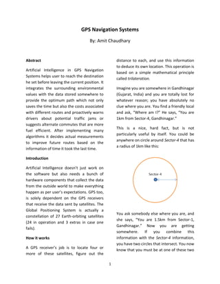
integrates the surrounding environmental Imagine you are somewhere in Gandhinagar
values with the data stored somewhere to (Gujarat, India) and you are totally lost for
provide the optimum path which not only whatever reason; you have absolutely no
saves the time but also the costs associated clue where you are. You find a friendly local
with different routes and proactively warns and ask, “Where am I?” He says, “You are
drivers about potential traffic jams or 1km from Sector-4, Gandhinagar.”
suggests alternate commutes that are more
This is a nice, hard fact, but is not
fuel efficient. After implementing many
particularly useful by itself. You could be
algorithms it decides actual measurements
anywhere on circle around Sector-4 that has
to improve future routes based on the
a radius of 1km like this:
information of time it took the last time.
Introduction
Artificial Intelligence doesn’t just work on
the software but also needs a bunch of
hardware components that collect the data
from the outside world to make everything
happen as per user’s expectations. GPS too,
is solely dependent on the GPS receivers
that receive the data sent by satellites. The
Global Positioning System is actually a
You ask somebody else where you are, and
constellation of 27 Earth-orbiting satellites
she says, “You are 1.5km from Sector-1,
(24 in operation and 3 extras in case one
Gandhinagar.” Now you are getting
fails).
somewhere. If you combine this
How it works information with the Sector-4 information,
you have two circles that intersect. You now
A GPS receiver’s job is to locate four or
know that you must be at one of these two
more of these satellites, figure out the
1
2. intersection points, if you are 1km from The location of at least three
Sector-4 and 1.5km from Sector-1. satellites above you
The distance between you and each
of those satellites
The GPS receiver figures out of these things
out by analyzing high-frequency, low-power
radio signals from the GPS satellites. Radio
waves are electromagnetic energy, which
means they travel at the speed of light
(about 1,86,000 miles per second). The
receiver can figure out how far the signal
has travelled by timing how long it took the
signal to arrive. At a particular time (let’s
If a third person tells you that you are say midnight), the satellite begins
0.90km from Sector-6, Gandhinagar, you transmitting a long, digital pattern called a
can eliminate one of the possibilities, pseudo-random code. The receiver begins
because the third circle will only intersect running the same digital pattern also
with one of these points. You now know exactly at midnight. When the satellite’s
exactly where you are – Sector-3, signal reaches the receiver, its transmission
Gandhinagar. of the pattern will lag a bit behind the
receiver’s playing of the pattern.
The length of the delay is equal to the
signal’s travel time. The receiver multiplies
this time by the speed of light to determine
how far the signal has travelled. Assuming
the signal travelled in a straight line, this is
the distance from receiver to satellite.
In order to make this measurement, the
receiver and satellite both needs clocks that
can be synchronized down to the
nanosecond. To make a satellite positioning
system using only synchronized clocks, you
would need to have atomic clocks not only
on all the satellites, but also in the receiver
In order to make this simple calculation, the itself. But atomic clocks cost somewhere
GPS receiver has to know two things: between $50,000 and $100,000, which
2
3. makes them a just bit too expensive for method assumes the radio signals will make
everyday consumer use. their way through the atmosphere at a
consistent speed (the speed of light). In
The GPS has a clever, effective solution to
fact, the Earth’s atmosphere slows the
this problem. Every satellite contains an
electromagnetic energy down somewhat,
expensive atomic clock, but the receiver
particularly as it goes through the
itself uses an ordinary quartz clock, which it
ionosphere and troposphere. The delay
constantly resets. In a nutshell, the receiver
varies depending on where you are on
looks at incoming signals from four or more
Earth, which means it’s difficult to
satellites and gauges its own accuracy. In
accurately factor this into the distance
other words, there is only one value for the
calculations. Problems can also occur when
current time that the receiver can use. The
radio signals bounce off large objects, such
correct time will cause all of the signals that
as skyscrapers, giving a receiver the
receiver is using to align at a single point in
impression that a satellite is farther away
space. That time value is the time value
than it actually is. On top of all that,
held by the atomic clocks in all of the
satellites sometimes just send out bad
satellites. So the receiver sets its clock to
almanac data, misreporting their own
that time value, and it then has the same
position.
time value that all the atomic clocks in all of
the satellites have. The GPS receiver gets Differential GPS (DGPS) helps correct these
atomic clock accuracy for free. errors. The basic idea is to gauge GPS
inaccuracy at a stationary receiver station
In order for the distance information to be
with a known location. Since the DGPS
of any use, the receiver also has to know
hardware at the station already knows its
where the satellites actually are. This isn’t
own position, it can easily calculate its
particularly difficult because the satellites
receiver’s inaccuracy. The station then
travel in very high and predictable orbits.
broadcasts a radio signal to all DGPS-
The GPS receiver simply stores an almanac
equipped receivers in the area, providing
that tells it where every satellite should be
signal correction information for that area.
at any given time. Things like the pull of the
In general, access to this correction
moon and the sun do change the satellites’
information makes DGPS receivers much
orbits very slightly, but the Department of
more accurate than ordinary receivers.
Defense constantly monitors their exact
positions and transmits any adjustments to Based on the calculations, the algorithm to
all GPS receivers as part of the satellites’ find out the user’s position can easily know
signals. the longitude, latitude and altitude of its
current position. To make the navigation
These calculations work pretty well, but
more user-friendly, most receivers plug this
inaccuracies do pop up. For one thing, this
raw data into map files stored in memory. A
3
4. standard GPS receiver will not place you on
a map at any particular location (in our case
Sector-3), but will also trace your path
across a map as you move. If you leave your
Source
receiver on, it can stay in constant
(Sector-3)
communication with GPS satellites to see
how your location is changing. With this
information and its built-in clock, the
receiver can give you several pieces of
valuable information:
How far you’ve travelled
How long you’ve been travelling
Your current speed
Your average speed
A bread crumb trail showing you
exactly where you have travelled on
the map
The estimated time of arrival at your
destination if you maintain your
current speed
As we have now seen how to infer the
correct position of any source, in the same
way we can obtain the destination point by
above computations. But the problem is not
finding the path between the source
(Sector-3) and destination (for instance,
Sector-21), but is to find optimum path. To
see the practical of it, you can have a look
at the screenshots to reach Sector-21
considering that efficient algorithms are
implemented.
Destination
(Sector-21)
4
5. Select the
source as
Sector-3
and
destination
Sector-21
The path shown in blue color is the
optimum path provided by Google with the
total distance (5.8km from Sector-3 to
Sector-21) and the approximate time (10
minutes).
Conclusion
To search the optimum path, the algorithms
are fully dependent on the data. The more
the data, the better the results are. We may
need heuristics techniques, to select the
best possible path or use DFS (Depth-First-
Search) algorithm to reach the destination,
and once it is reached, there is no need to
look up other solutions unlike BFS (Breadth-
First-Search).
5