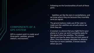
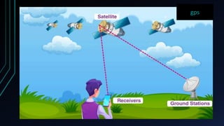
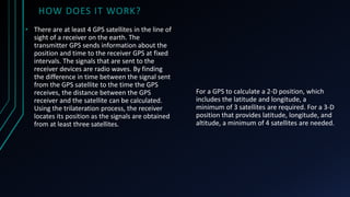
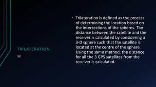
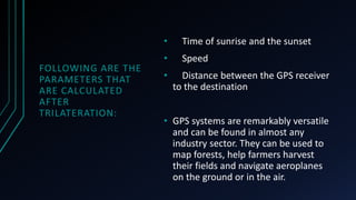
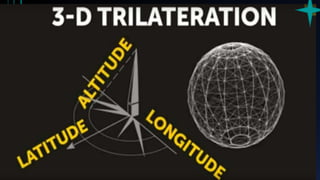
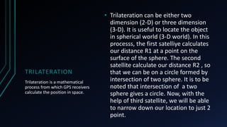
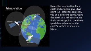
Global positioning system
GPS
CONTENTS
• What is GPS?
• Components of a GPS system
• How does GPS Work?
• Quick Summary
• What Is Trilateration?
What is global positioning
system?
GPS
In ancient times, humans relied on the skies for
navigation. We depended on objects in the sky to
deduce where we were and how to get to other
places. Ancient sailors used the constellations in the
night sky to assess where they were. Compasses,
maps and astrolabes are among the early tools used
by ocean navigators. In the modern era, technological
and electronic equivalents have predominantly
replaced these tools. Now we only need a simple
hand-held GPS (short for Global Positioning System)
receiver to comprehend precisely where we are in the
world.
GPS stands for Global Positioning System. It is a radio navigation system
used on land, sea, and air to determine the exact location, time and
velocity irrespective of weather conditions. The US military first used it in
the year 1960
COMPONENTS OF A
GPS SYSTEM
GPS is a system and it is made up of
three parts: satellites, ground
stations, and receivers.
• Following are the functionalities of each of these
parts:
• Satellites act like the stars in constellations, and
we know where they are because they invariably
send out signals.
• The ground stations make use of the radar to
make sure the satellites are actually where we
think they are.
• A receiver is a device that you might find in your
phone or in your car and it constantly seeks for
the signals from the satellites. The receiver
figures out how far away they are from some of
them. Once the receiver calculates its distance
from four or more satellites, it knows exactly
where you are.
gps
HOW DOES IT WORK?
For a GPS to calculate a 2-D position, which
includes the latitude and longitude, a
minimum of 3 satellites are required. For a 3-D
position that provides latitude, longitude, and
altitude, a minimum of 4 satellites are needed.
• There are at least 4 GPS satellites in the line of
sight of a receiver on the earth. The
transmitter GPS sends information about the
position and time to the receiver GPS at fixed
intervals. The signals that are sent to the
receiver devices are radio waves. By finding
the difference in time between the signal sent
from the GPS satellite to the time the GPS
receives, the distance between the GPS
receiver and the satellite can be calculated.
Using the trilateration process, the receiver
locates its position as the signals are obtained
from at least three satellites.
SUMMARY
Quick
• GPS is a system of 30+ navigation
satellites orbiting the Earth. We know
their location precisely because they
invariably send out signals. The GPS
receiver in your phone receives these
signals. Once the receiver calculates
its distance from four or more GPS
satellites, it can figure out exactly
where you are.
TRILATERATION
3d
• Trilateration is defined as the process
of determining the location based on
the intersections of the spheres. The
distance between the satellite and the
receiver is calculated by considering a
3-D sphere such that the satellite is
located at the centre of the sphere.
Using the same method, the distance
for all the 3 GPS satellites from the
receiver is calculated.
FOLLOWING ARE THE
PARAMETERS THAT
ARE CALCULATED
AFTER
TRILATERATION:
• Time of sunrise and the sunset
• Speed
• Distance between the GPS receiver
to the destination
• GPS systems are remarkably versatile
and can be found in almost any
industry sector. They can be used to
map forests, help farmers harvest
their fields and navigate aeroplanes
on the ground or in the air.
RATION
TRILATERATION
Trilateration is a mathematical
process from which GPS receivers
calculate the position in space.
• Trilateration can be either two
dimension (2-D) or three dimension
(3-D). It is useful to locate the object
in spherical world (3-D world). In this
processs, the first satelliye calculates
our distance R1 at a point on the
surface of the sphere. The second
satellite calculate our distance R2 , so
that we can be on a circle formed by
intersection of two sphere. It is to be
noted that intersection of a two
sphere gives a circle. Now, with the
help of third satellite, we will be able
to narrow down our location to just 2
point.
Here , the intersection for a
circle and a sphere gives two
point (i.e , satellites can show
you at 2 different point). Using
the earth as a 4th surface, we
find a correct point , the three
special coordinates on the
earth's surface as shown in
figure.

Global positioning system ppt finale.pptx

  • 1.
  • 2.
    CONTENTS • What isGPS? • Components of a GPS system • How does GPS Work? • Quick Summary • What Is Trilateration?
  • 3.
    What is globalpositioning system? GPS
  • 4.
    In ancient times,humans relied on the skies for navigation. We depended on objects in the sky to deduce where we were and how to get to other places. Ancient sailors used the constellations in the night sky to assess where they were. Compasses, maps and astrolabes are among the early tools used by ocean navigators. In the modern era, technological and electronic equivalents have predominantly replaced these tools. Now we only need a simple hand-held GPS (short for Global Positioning System) receiver to comprehend precisely where we are in the world.
  • 5.
    GPS stands forGlobal Positioning System. It is a radio navigation system used on land, sea, and air to determine the exact location, time and velocity irrespective of weather conditions. The US military first used it in the year 1960
  • 6.
    COMPONENTS OF A GPSSYSTEM GPS is a system and it is made up of three parts: satellites, ground stations, and receivers. • Following are the functionalities of each of these parts: • Satellites act like the stars in constellations, and we know where they are because they invariably send out signals. • The ground stations make use of the radar to make sure the satellites are actually where we think they are. • A receiver is a device that you might find in your phone or in your car and it constantly seeks for the signals from the satellites. The receiver figures out how far away they are from some of them. Once the receiver calculates its distance from four or more satellites, it knows exactly where you are.
  • 7.
  • 8.
    HOW DOES ITWORK? For a GPS to calculate a 2-D position, which includes the latitude and longitude, a minimum of 3 satellites are required. For a 3-D position that provides latitude, longitude, and altitude, a minimum of 4 satellites are needed. • There are at least 4 GPS satellites in the line of sight of a receiver on the earth. The transmitter GPS sends information about the position and time to the receiver GPS at fixed intervals. The signals that are sent to the receiver devices are radio waves. By finding the difference in time between the signal sent from the GPS satellite to the time the GPS receives, the distance between the GPS receiver and the satellite can be calculated. Using the trilateration process, the receiver locates its position as the signals are obtained from at least three satellites.
  • 9.
    SUMMARY Quick • GPS isa system of 30+ navigation satellites orbiting the Earth. We know their location precisely because they invariably send out signals. The GPS receiver in your phone receives these signals. Once the receiver calculates its distance from four or more GPS satellites, it can figure out exactly where you are.
  • 10.
    TRILATERATION 3d • Trilateration isdefined as the process of determining the location based on the intersections of the spheres. The distance between the satellite and the receiver is calculated by considering a 3-D sphere such that the satellite is located at the centre of the sphere. Using the same method, the distance for all the 3 GPS satellites from the receiver is calculated.
  • 11.
    FOLLOWING ARE THE PARAMETERSTHAT ARE CALCULATED AFTER TRILATERATION: • Time of sunrise and the sunset • Speed • Distance between the GPS receiver to the destination • GPS systems are remarkably versatile and can be found in almost any industry sector. They can be used to map forests, help farmers harvest their fields and navigate aeroplanes on the ground or in the air.
  • 12.
  • 13.
    TRILATERATION Trilateration is amathematical process from which GPS receivers calculate the position in space. • Trilateration can be either two dimension (2-D) or three dimension (3-D). It is useful to locate the object in spherical world (3-D world). In this processs, the first satelliye calculates our distance R1 at a point on the surface of the sphere. The second satellite calculate our distance R2 , so that we can be on a circle formed by intersection of two sphere. It is to be noted that intersection of a two sphere gives a circle. Now, with the help of third satellite, we will be able to narrow down our location to just 2 point.
  • 14.
    Here , theintersection for a circle and a sphere gives two point (i.e , satellites can show you at 2 different point). Using the earth as a 4th surface, we find a correct point , the three special coordinates on the earth's surface as shown in figure.