
Recommended
More Related Content
Similar to gps overview.pdf for military personneland students
Similar to gps overview.pdf for military personneland students (20)
Recently uploaded
Recently uploaded (20)
gps overview.pdf for military personneland students
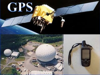
- 3. What is GPS? The Global Positioning System
- 4. What is GPS? GPS is a network of satellites that continuously transmit coded information, which makes it possible to precisely identify locations on earth by measuring distance from the satellites.
- 6. THREE SEGMENTS OF GPS Monitor stations • Diego Garcia • Ascension Island • Kwajalein • Hawaii USER SEGMENT SPACE SEGMENT GPS Control Colorado Springs GROUND CONTROL SEGMENT
- 7. GPS - A Constellation of about 24 Navigation Satellites Orbiting the Earth C CMT
- 8. GPS GEN. GPS BASED ON A CONSTELLATION OF - 24 SATLS. NO OF ACTIVE SATLS - 21 NO OF ACTIVE RES - 3 DIST OF ORBIT FROM SURFACE OF EARTH - 20,233 KM NO OF ORBITS - 6 SATL/ORBIT - 4
- 9. Space Segment Description • 24 satellites – 6 planes with 55° rotation – Each plane has 4 or 5 satellites • Very high orbit – 20,200 km (12,600 miles) – 1 revolution in approximately 12 hours – For accuracy – Survivability – Coverage
- 10. GROUND CONTROL SEGMENT Monitor stations • Diego Garcia • Ascension Island • Kwajalein • Hawaii GPS Control Colorado Springs NAVDATA - Satellite health, satellite clock corrections, and ephemeris parameters. Ground Control Segment Monitors Ephemeris The position information broadcast from the satellite is referred to as the ephemeris. The ephemeris contains precise information about the satellite’s orbit. Each satellite has an ephemeris.
- 12. USER SEGMENT • HAND HELD GPS Receiver • CAR GPS Receiver • AIRCRAFT GPS Receiver • DIFFERENTIAL GPS ANTENNA MICRO PROCESSOR CONTROL & DISPLAY UNIT RECORDING DEVICE POWER SUPPLY
- 14. How is GPS technology used? GPS is used to determine position Latitude, Longitude, Altitude of an object Applications range from naviation to data collection for GIS/Mapping
- 15. What is GIS? Geographic Information Systems GIS allows us to create maps GIS provides tools for analyzing geographic information
- 17. Specifics on GPS Technology - How GPS receiver calculates position - How accurate is GPS - What affects GPS accuracy
- 18. Not To Scale! GPS receiver tracks satellites and uses trilateration to calculate its position C CMT
- 19. Not To Scale! To calculate a 3D position (X, Y, Z), GPS receiver must track at least 4 SV! C CMT
- 20. Where are you? Simplified Example: You are somewhere inside the blue circle. You know you are distance A from point 1, and distance B from point 2. Position calculated by trilateration A B C CMT
- 21. Solution: Draw a circle around point 1 of radius A Draw a circle around point 2 of radius B. Find the place where the yellow and red circles intersect. Where are you? (Remember: you are inside the blue circle) Trilateration Example A B You are here C CMT
- 22. GPS & Trilateration A GPS receiver uses the principle of trilateration to calculate its position. In GPS this is really three dimensional problem, but that just makes things a little more complex to solve, and we will leave the actual computation to a computer anyway. Notice: The more accurately a GPS receiver can measure the distance from itself to a GPS satellite the more accurately it can determine its position ! B A C CMT
- 23. Summary of GPS, Trilateration & Accuracy GPS accuracy is dependent upon the ability of the GPS receiver to calculate the distance between satellites and itself More accurate GPS technology requires a more precise measurement of the distance between each GPS SV and the GPS receiver The more accurately a GPS receiver measures the distances, the more accurate the calculated positions (calculated X, Y, Z)
- 24. LEVELS OF SERVICES u 1. STANDARD POSITIONING SERVICE SPS u 2. PRECISE POSITIONING SERVICE PPS
- 25. GOOGLE EARTH
- 26. GOOGLE EARTH
- 27. ZOOM EFFECT
- 28. What contributes to error in GPS positions? Ionospheric / Tropospheric conditions Measurement noise Ephemeris Data Satellite Clock Drift Multipath interference Selective Ability (SA)
- 29. THANK YOU