GIS - Asset Management - Sea Ports
•
2 likes•340 views

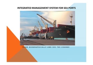
This document proposes an integrated management system for sea ports using geographic information systems (GIS). The key features of the proposed system include asset mapping, monitoring, and management; business intelligence maps and data analytics; security management; and integration with existing management information systems. The system aims to provide situational awareness of port assets, efficient utilization of assets, and effective planning and response to emergencies. Benefits include increased asset tracking and utilization, improved decision-making based on operational visualization, and maximized use of port infrastructure and assets.
Report
Share
Report
Share
Download to read offline

Recommended
GIS in property management
This document discusses the use of geographic information systems (GIS) in facilities management and property maintenance. It begins with introductions to facilities management and GIS, explaining how GIS can be used to manage spatial data related to properties. It then discusses specific GIS applications for various stages of property management, such as site selection, space management, and maintenance. The document concludes by outlining steps for implementing a GIS system, including developing requirements, evaluating options, creating an implementation plan, acquisition, and operational procedures. Overall, the document provides an overview of how GIS technologies can enhance property management and maintenance activities.
Smart City and Digital Twin
I gave this talk to the students from Adama Science Technology University (ASTU), Ethiopia who attended the SNU's class.
“Efficient Deep Learning for 3D Point Cloud Understanding,” a Presentation fr...
“Efficient Deep Learning for 3D Point Cloud Understanding,” a Presentation fr...Edge AI and Vision Alliance
For the full video of this presentation, please visit: https://www.edge-ai-vision.com/2021/10/efficient-deep-learning-for-3d-point-cloud-understanding-a-presentation-from-facebook/
Bichen Wu, Research Scientist at Facebook Reality Labs, presents the “Efficient Deep Learning for 3D Point Cloud Understanding” tutorial at the May 2021 Embedded Vision Summit.
Understanding the 3D environment is a crucial computer vision capability required by a growing set of applications such as autonomous driving, AR/VR and AIoT. 3D visual information, captured by LiDAR and other sensors, is typically represented by a point cloud consisting of thousands of unstructured points.
Developing computer vision solutions to understand 3D point clouds requires addressing several challenges, including how to efficiently represent and process 3D point clouds, how to design efficient on-device neural networks to process 3D point clouds, and how to easily obtain data to train 3D models and improve data efficiency. In this talk, Wu shows how his company addresses these challenges as part of its “SqeezeSeg” research and presents a highly efficient, accurate, and data-efficient solution for on-device 3D point-cloud understanding.OSM and QGIS
Jerry Clough presents techniques for analyzing OpenStreetMap data using QGIS. He discusses using OSM data to simulate the European Urban Atlas project and mapping retail locations. Case studies include analyzing pub density in Britain, simulating land use classification, and tracking street light and retail mappings. Challenges with OSM data like polygon overlaps and tagging variations are also covered.
Outside of the Box Integrations
In 2015, CoServ made the determination to migrate all asset data management into IBM Maximo. We opted to leverage ArcGIS for Server as our main integration point between Maximo and GIS. By hosting our utility infrastructure data in feature services, we allowed Maximo to view spatially enabled information for visualization within its own environment. Additionally, Maximo updates feature classes and their related tables based upon changes made in Maximo seamlessly through the services. By leveraging Global IDs and GUIDs as the direct linkage between Maximo assets and GIS features, CoServ is now able to ingest Maximo assets directly into the GIS environment. This presented GIS end users access to asset related information in their native environment. The migration has been a highly successful implementation. It has alleviated the strain on GIS to manage and maintain asset related information while still providing a way for GIS to access it. This solution has provided a stable integration between the two environments with minimal customizations. By thinking a bit out of the box, CoServ was able to create a unique integration that solved all of our problems.
Smart Taipei Overview
Taipei is implementing a smart city initiative called Smart Taipei that focuses on smart living, cybersecurity, transportation, public housing, healthcare, education, and payments. It aims to facilitate innovation through proof of concept projects, engage stakeholders, and change culture. Some key projects include a smart Taipei main station, smart streetlights, a smart parking system, smart waste bins, and using AI for traffic flow calculation and pollution traceability. The initiative brings innovation to government and opens channels for citizen participation.
Smart city as a Digital Twin
지난 4월 3일에 대전 KAIST 증강현실연구센터 콜로키움에서 발표한 자료입니다.
‘Digital Twin’ is a digital replication of real world objects, processes, phenomena that can be used for various purposes. Digital twin concept backs to manufacturing industry in early 2000s for the PLM (Product Lifecycle Management) purposes. It is based on the idea that a digital informational construct about a physical system could be created as an entity on its own. As cities are going through digital transformation, there are many attempts to apply digital twin concept to manage urban issues. Those attempts look set to play an increasingly important role in the creation of smart cities around the world and in addressing major public health, safety and environmental issues. Bringing the virtual and real worlds together in this way can help to give better analysis, visualization, and simulation to decision-making process. This will be a multi-way process with iterative feedback among stakeholders. In this colloquium, I talked about the recent trends of Smart City from the perspective of digital twin.
NDGeospatialSummit2019 - ArcGIS Pro – Next-Generation Desktop GIS
ArcGIS Pro is a new 64-bit desktop GIS application that combines 2D and 3D mapping, analysis, and editing in one application. It has a contextual ribbon interface and allows users to work with multiple maps and layouts simultaneously. ArcGIS Pro can perform the same analysis, editing, mapping, and sharing capabilities as ArcMap but with improved performance. It is intended to replace ArcMap as the primary desktop GIS software. Users can import existing ArcMap documents and customize ArcGIS Pro. It is licensed through ArcGIS Online or Portal and can be virtualized. Future development will focus on new functionality being added to ArcGIS Pro rather than ArcMap.
DE - Smart Parking System.pptx
This document describes a smart parking system created by a group of students that uses cameras and artificial intelligence to manage a parking lot. The system recognizes vehicle numbers using embedded cameras, tracks which space a vehicle parks in, and updates parking information. It can also detect collisions. The system aims to introduce an intelligent parking management solution using technologies like sensors, IOT, and mobile applications to help drivers find available spaces and pay for parking remotely.
Cyber security in smart cities
This talk was presented at Zewail city workshop on intelligent systems and application on Saturday 7 March 2015 by Dr. Amira (SRGE member)
NDGISUC2017 - Introducing ArcGIS Pro
This document provides an overview of ArcGIS Pro, a new desktop GIS application from Esri. The summary includes:
- ArcGIS Pro is a 64-bit application with improved performance for mapping, visualization, editing, and analysis tasks.
- It is integrated with ArcGIS Online and ArcGIS Enterprise and allows combined 2D/3D experiences.
- ArcGIS Pro has additional capabilities over ArcMap like improved charting and runs alongside ArcMap as part of the ArcGIS Desktop application.
Applications of AI in the geospatial domain
Presentation on applications of AI in the geospatial domain at the Fourth Edition of AI in Practice (6th November 2019, Startup Village, Amsterdam, The Netherlands)
Erik Van Der Zee, Enterprise Architect, Geodan
GIS in National Security
The document discusses how GIS can help address national security challenges through four components: data management, planning and analysis, field mobility, and situational awareness. It provides examples of how GIS has supported responses to issues like wildfires, pandemics, port security, border management, and more. The key advantages highlighted are creating a common operating platform to enable borderless cooperation, approaching problems geographically to foster understanding, and leveraging social media.
Getting to Know ArcGIS Pro
ArcGIS Pro is Esri's new desktop GIS software that integrates 2D and 3D mapping, analysis, and editing capabilities. It combines the functionality of ArcMap, ArcCatalog, ArcGlobe, and ArcScene into a single application with a modern 64-bit architecture. ArcGIS Pro allows users to work with multiple maps and layouts simultaneously. It also features tasks that guide users through workflows. The software is tightly integrated with ArcGIS Online and portal environments. Esri is continuously improving ArcGIS Pro based on customer feedback, with new releases adding capabilities like vector tiles, publishing by reference, 3D scenes, and concurrent licensing.
RPA.pptx
RPA + AI = ?
RPA (Robotic Process Automation) + AI (Artificial Intelligence) = Intelligent Automation
Intelligent Automation is the combination of RPA and AI technologies. It integrates the capabilities of RPA, which automates rule-based, repetitive tasks, with AI technologies such as machine learning, natural language processing, computer vision, and cognitive automation. This combination allows automation systems to handle more complex, cognitive tasks, and make intelligent decisions.
By incorporating AI into RPA, Intelligent Automation enables bots to understand and interpret unstructured data, learn from patterns and examples, and interact more intelligently with humans and systems. It enhances the ability of bots to handle exceptions, adapt to new scenarios, and perform tasks that involve judgment, reasoning, or natural language understanding.
Intelligent Automation can be used to automate processes that involve unstructured data processing, sentiment analysis, document classification, virtual assistants, predictive analytics, and more. It brings together the efficiency and accuracy of RPA with the cognitive capabilities of AI, enabling organizations to achieve higher levels of automation, productivity, and intelligent decision-making.
Access control system
Restrict Unauthorized Access in Secured Area
User Access on Advance Biometric Technology
Restrict User Access based on User, Zone and Time
Require Advance Access Control Features
Centralized Monitoring and Control
Real-Time Notifications on Exception
Integrate with Video Surveillance and other Devices
Conglomerates Multiple branches into One Platform
Smart Fleet Management with IoT
Fleet management systems monitor different kinds of motor vehicles such as cars, vans, trucks, aircraft, ships, and rail cars. Managing a fleet of vehicles is a challenging task. Fleet Management System Or Enterprise Asset management system allows companies to remove or minimize the risks associated with vehicle investment and improve efficiency, productivity, and compliance with government legislation.
Are you looking to deploy new technologies and innovative solutions for Asset Management or Field Service? Contact us for a detailed presentation on IoT, Asset Management, or Field service.
Semantic 3D City Models with CityGML
Presentació realitzada pel Prof. Dr. Thomas H. Kolbe, de l'Institut für Geodäsie, Geoinformatik und Landmanagement de la Universitat Tècnica de Munic, el dia 22/01/2015 a l'ICGC
RESERVATION BASED PARKING SYSTEM USING SMS
BY USING SMS RESERVATION IS SO EASY WITHOUT WASTING TIME SEARCHING FOR PARKING SPOTS AS COMPARED TO EXISTING SYSTEM
Ai and traffic management application v1.0
The document discusses how big data and artificial intelligence can enable smart traffic management. It provides examples of how AI cameras, cellular data collection from mobile apps, and edge computing can be used with machine learning algorithms to analyze traffic patterns, detect violations, and optimize traffic signal timing. The results include reducing traffic delays, improving traffic flow, increasing road safety, and enhancing law enforcement efficiency.
Fnal year project on iot accident detection and tracking system 26-may 21'
This presentation is based upon final year project supervised under the premises of cummins college of engineering for women, pune, on IoT based Accident Detection & Tracking System and also contributing towards smart healthcare sector, by initiating theologies of research or the ways of research can be taken out in this area aswell, to make this system further more intelligent on predictions conducted from the studies of statistics and machine learning, to automate this research from data log and system can be made smart supervisory, to contribute towards smart healthcare sector.
smart city - smart healthcare sector- industry 4.0
Digital Twin: Starting the journey
The document discusses preparing organizations for digital twins using IoT platforms and technologies like AI, analytics, and cloud services. It emphasizes positioning AI to augment human insights, reinventing operations with new digital data sources, and leveraging proven industrial expertise. Digital twins can provide real-time virtual representations of physical systems to improve decision making across their lifecycles using multiple data sources and models. The document recommends preparing for digital twins as part of an extensible IoT platform.
Building the Metaverse
The document discusses building the metaverse through 7 layers: experiences, discovery, creator economy, spatial computing, decentralization, human interface, and infrastructure. It describes over 160 companies working in these layers and 9 megatrends like virtual mainstreaming, machine intelligence, and blockchain adoption that are enabling the metaverse. The metaverse will be led by creators using new tools to build distributed, open experiences across immersive 3D worlds.
ArcGIS for Local Government
ArcGIS for Local Government templates provide multiple solutions to make the most of your GIS investment.
APPLICATIONS OF GIS IN REMOTE SENSING
GIS can be applied in many domains to create awareness and share knowledge. Major applications of GIS include planning and engineering, facilities management, environmental and natural resource management, land information systems, and street networks. GIS is used for tasks like locating underground pipes, transportation planning, disaster management, land use planning, and more. The document discusses several examples of GIS applications and concludes that GIS integration will continue expanding into many fields.
Artificial intelligence in autonomous vehicle
Présentation réalisé pour le cours d'anglais de la Licence 3 Miashs parcours Miage réalisée l'université de Toulouse Capitole conjointement à l'université Toulouse Paul Sabatier
Smart parking
This document describes a proposed smart parking system with the following key elements:
- The system uses ultrasonic sensors in each parking space to detect vehicles and coordinate payments and check in/out functions.
- Users can check in by entering their phone number, then pay automatically using RFID or by entering their card details. They can check out using their phone number.
- The spaces communicate information to a central coordinator, and a mobile app allows remote check in, payment and check out.
- Future improvements could include GPS location tracking, additional sensors for better detection, and integrating payments with bank accounts or existing systems.
What is Data Analysis and Machine Learning?
Machine learning and data analytics are growing fields that can provide valuable insights. Machine learning uses algorithms to analyze data, discover patterns, and make predictions without being explicitly programmed. There are several types of machine learning including supervised learning (classification and regression), unsupervised learning (clustering), reinforcement learning, and evolutionary learning. Machine learning has many applications such as automatic driving, image and speech recognition, medical diagnosis, credit risk assessment, and more. As data collection increases across industries, machine learning is becoming increasingly important.
KyzerResume
John Jeffery Kyzer has over 15 years of experience processing satellite and aerial imagery into orthorectified and mosaic image products using software such as ArcGIS and PCI. He has a background in geography with a focus on remote sensing, cartography, GIS and physics. Kyzer also has experience as an electronic warfare technician in the U.S. Navy from 1985-1993 and currently serves in the Air National Guard where he deploys and maintains satellite communications equipment.
Implementing ArcGIS for Water Utilities
ArcGIS for Water Utilities is a collection of Esri products configured specifically for water utilities. It includes maps and apps to support common water utility workflows such as maintaining asset information, designing capital projects, optimizing field operations, understanding operations status, and connecting with customers. These workflows integrate the common GIS patterns of asset management, planning and analysis, field mobility, operational awareness, and constituent engagement. The ArcGIS platform allows water utilities to deploy these solutions to unlock benefits and efficiently manage their operations.
More Related Content
What's hot
DE - Smart Parking System.pptx
This document describes a smart parking system created by a group of students that uses cameras and artificial intelligence to manage a parking lot. The system recognizes vehicle numbers using embedded cameras, tracks which space a vehicle parks in, and updates parking information. It can also detect collisions. The system aims to introduce an intelligent parking management solution using technologies like sensors, IOT, and mobile applications to help drivers find available spaces and pay for parking remotely.
Cyber security in smart cities
This talk was presented at Zewail city workshop on intelligent systems and application on Saturday 7 March 2015 by Dr. Amira (SRGE member)
NDGISUC2017 - Introducing ArcGIS Pro
This document provides an overview of ArcGIS Pro, a new desktop GIS application from Esri. The summary includes:
- ArcGIS Pro is a 64-bit application with improved performance for mapping, visualization, editing, and analysis tasks.
- It is integrated with ArcGIS Online and ArcGIS Enterprise and allows combined 2D/3D experiences.
- ArcGIS Pro has additional capabilities over ArcMap like improved charting and runs alongside ArcMap as part of the ArcGIS Desktop application.
Applications of AI in the geospatial domain
Presentation on applications of AI in the geospatial domain at the Fourth Edition of AI in Practice (6th November 2019, Startup Village, Amsterdam, The Netherlands)
Erik Van Der Zee, Enterprise Architect, Geodan
GIS in National Security
The document discusses how GIS can help address national security challenges through four components: data management, planning and analysis, field mobility, and situational awareness. It provides examples of how GIS has supported responses to issues like wildfires, pandemics, port security, border management, and more. The key advantages highlighted are creating a common operating platform to enable borderless cooperation, approaching problems geographically to foster understanding, and leveraging social media.
Getting to Know ArcGIS Pro
ArcGIS Pro is Esri's new desktop GIS software that integrates 2D and 3D mapping, analysis, and editing capabilities. It combines the functionality of ArcMap, ArcCatalog, ArcGlobe, and ArcScene into a single application with a modern 64-bit architecture. ArcGIS Pro allows users to work with multiple maps and layouts simultaneously. It also features tasks that guide users through workflows. The software is tightly integrated with ArcGIS Online and portal environments. Esri is continuously improving ArcGIS Pro based on customer feedback, with new releases adding capabilities like vector tiles, publishing by reference, 3D scenes, and concurrent licensing.
RPA.pptx
RPA + AI = ?
RPA (Robotic Process Automation) + AI (Artificial Intelligence) = Intelligent Automation
Intelligent Automation is the combination of RPA and AI technologies. It integrates the capabilities of RPA, which automates rule-based, repetitive tasks, with AI technologies such as machine learning, natural language processing, computer vision, and cognitive automation. This combination allows automation systems to handle more complex, cognitive tasks, and make intelligent decisions.
By incorporating AI into RPA, Intelligent Automation enables bots to understand and interpret unstructured data, learn from patterns and examples, and interact more intelligently with humans and systems. It enhances the ability of bots to handle exceptions, adapt to new scenarios, and perform tasks that involve judgment, reasoning, or natural language understanding.
Intelligent Automation can be used to automate processes that involve unstructured data processing, sentiment analysis, document classification, virtual assistants, predictive analytics, and more. It brings together the efficiency and accuracy of RPA with the cognitive capabilities of AI, enabling organizations to achieve higher levels of automation, productivity, and intelligent decision-making.
Access control system
Restrict Unauthorized Access in Secured Area
User Access on Advance Biometric Technology
Restrict User Access based on User, Zone and Time
Require Advance Access Control Features
Centralized Monitoring and Control
Real-Time Notifications on Exception
Integrate with Video Surveillance and other Devices
Conglomerates Multiple branches into One Platform
Smart Fleet Management with IoT
Fleet management systems monitor different kinds of motor vehicles such as cars, vans, trucks, aircraft, ships, and rail cars. Managing a fleet of vehicles is a challenging task. Fleet Management System Or Enterprise Asset management system allows companies to remove or minimize the risks associated with vehicle investment and improve efficiency, productivity, and compliance with government legislation.
Are you looking to deploy new technologies and innovative solutions for Asset Management or Field Service? Contact us for a detailed presentation on IoT, Asset Management, or Field service.
Semantic 3D City Models with CityGML
Presentació realitzada pel Prof. Dr. Thomas H. Kolbe, de l'Institut für Geodäsie, Geoinformatik und Landmanagement de la Universitat Tècnica de Munic, el dia 22/01/2015 a l'ICGC
RESERVATION BASED PARKING SYSTEM USING SMS
BY USING SMS RESERVATION IS SO EASY WITHOUT WASTING TIME SEARCHING FOR PARKING SPOTS AS COMPARED TO EXISTING SYSTEM
Ai and traffic management application v1.0
The document discusses how big data and artificial intelligence can enable smart traffic management. It provides examples of how AI cameras, cellular data collection from mobile apps, and edge computing can be used with machine learning algorithms to analyze traffic patterns, detect violations, and optimize traffic signal timing. The results include reducing traffic delays, improving traffic flow, increasing road safety, and enhancing law enforcement efficiency.
Fnal year project on iot accident detection and tracking system 26-may 21'
This presentation is based upon final year project supervised under the premises of cummins college of engineering for women, pune, on IoT based Accident Detection & Tracking System and also contributing towards smart healthcare sector, by initiating theologies of research or the ways of research can be taken out in this area aswell, to make this system further more intelligent on predictions conducted from the studies of statistics and machine learning, to automate this research from data log and system can be made smart supervisory, to contribute towards smart healthcare sector.
smart city - smart healthcare sector- industry 4.0
Digital Twin: Starting the journey
The document discusses preparing organizations for digital twins using IoT platforms and technologies like AI, analytics, and cloud services. It emphasizes positioning AI to augment human insights, reinventing operations with new digital data sources, and leveraging proven industrial expertise. Digital twins can provide real-time virtual representations of physical systems to improve decision making across their lifecycles using multiple data sources and models. The document recommends preparing for digital twins as part of an extensible IoT platform.
Building the Metaverse
The document discusses building the metaverse through 7 layers: experiences, discovery, creator economy, spatial computing, decentralization, human interface, and infrastructure. It describes over 160 companies working in these layers and 9 megatrends like virtual mainstreaming, machine intelligence, and blockchain adoption that are enabling the metaverse. The metaverse will be led by creators using new tools to build distributed, open experiences across immersive 3D worlds.
ArcGIS for Local Government
ArcGIS for Local Government templates provide multiple solutions to make the most of your GIS investment.
APPLICATIONS OF GIS IN REMOTE SENSING
GIS can be applied in many domains to create awareness and share knowledge. Major applications of GIS include planning and engineering, facilities management, environmental and natural resource management, land information systems, and street networks. GIS is used for tasks like locating underground pipes, transportation planning, disaster management, land use planning, and more. The document discusses several examples of GIS applications and concludes that GIS integration will continue expanding into many fields.
Artificial intelligence in autonomous vehicle
Présentation réalisé pour le cours d'anglais de la Licence 3 Miashs parcours Miage réalisée l'université de Toulouse Capitole conjointement à l'université Toulouse Paul Sabatier
Smart parking
This document describes a proposed smart parking system with the following key elements:
- The system uses ultrasonic sensors in each parking space to detect vehicles and coordinate payments and check in/out functions.
- Users can check in by entering their phone number, then pay automatically using RFID or by entering their card details. They can check out using their phone number.
- The spaces communicate information to a central coordinator, and a mobile app allows remote check in, payment and check out.
- Future improvements could include GPS location tracking, additional sensors for better detection, and integrating payments with bank accounts or existing systems.
What is Data Analysis and Machine Learning?
Machine learning and data analytics are growing fields that can provide valuable insights. Machine learning uses algorithms to analyze data, discover patterns, and make predictions without being explicitly programmed. There are several types of machine learning including supervised learning (classification and regression), unsupervised learning (clustering), reinforcement learning, and evolutionary learning. Machine learning has many applications such as automatic driving, image and speech recognition, medical diagnosis, credit risk assessment, and more. As data collection increases across industries, machine learning is becoming increasingly important.
What's hot (20)
Fnal year project on iot accident detection and tracking system 26-may 21'
Fnal year project on iot accident detection and tracking system 26-may 21'
Similar to GIS - Asset Management - Sea Ports
KyzerResume
John Jeffery Kyzer has over 15 years of experience processing satellite and aerial imagery into orthorectified and mosaic image products using software such as ArcGIS and PCI. He has a background in geography with a focus on remote sensing, cartography, GIS and physics. Kyzer also has experience as an electronic warfare technician in the U.S. Navy from 1985-1993 and currently serves in the Air National Guard where he deploys and maintains satellite communications equipment.
Implementing ArcGIS for Water Utilities
ArcGIS for Water Utilities is a collection of Esri products configured specifically for water utilities. It includes maps and apps to support common water utility workflows such as maintaining asset information, designing capital projects, optimizing field operations, understanding operations status, and connecting with customers. These workflows integrate the common GIS patterns of asset management, planning and analysis, field mobility, operational awareness, and constituent engagement. The ArcGIS platform allows water utilities to deploy these solutions to unlock benefits and efficiently manage their operations.
Projects control managment
Gisystems is a consulting firm that provides project planning, management, administration and control services for engineering, architecture, and custom IT systems development projects. They ensure high quality services through trained staff, quality management systems, and state-of-the-art technologies for information collection, management and processing. Gisystems has experience providing these types of services for over $2 billion in infrastructure projects across many countries.
My presentation
This document discusses geospatial technology and geographic information systems (GIS). It defines key terms like GIS, remote sensing, and GPS. It describes how these systems collect and analyze geographic data. The document also discusses geospatial intelligence (GEOINT) and how GIS plays an important role in military and national security applications. Specific GEOINT software and tools are also summarized, like Intergraph, Pathfinder, and the Structured Geospatial Analytic Method (SGAM). The document concludes by noting the growth of geospatial technologies across many sectors.
GEOGRAPHIC INFORMATION SYSTEM.pdf
This document provides an overview of geographic information systems (GIS). It defines GIS as a computer system for capturing, storing, analyzing and displaying geographic data. The key components of a GIS are described as hardware, software, data, people, and methods. Common data formats are discussed, including vector data of points, lines and polygons, and raster data of pixels. The advantages and disadvantages of vector and raster data are also compared. Examples are given of how GIS is used in various fields such as government, business, military, research and everyday applications.
Geospatial data mgt and analysis on iCEOD platform
This document summarizes Muliaro Wafula's presentation on managing and analyzing geospatial data on iCEOD's open data platform. The presentation was given at the ISDE Digital Earth Summit in Beijing, China.
It describes iCEOD's key objectives of promoting open data research and innovation. It also discusses JKUAT's open research data policy which aims to encourage sharing and reuse of research data.
The presentation then demonstrates how iCEOD uses IBM tools like dashDB and geospatial analytics to manage and analyze geospatial data, giving examples of visualizing weather warning data and customer locations on maps. Potential applications of geospatial analysis in various domains are also highlighted.
Data IS the new dollar
Presentation given at the GISSA Gauteng meeting in March 2017 to cover data value, integrity and professionalism.
G I S.pptx
GIS is a computer system that can capture, store, analyze, and display geographically referenced information. A GIS integrates spatial data like maps with non-spatial data like numbers and attributes. It has four main components - hardware, software, data, and people. GIS software allows users to analyze geographic data to understand relationships and patterns. The information can be presented in maps, reports, and other visualizations. GIS is used in many fields like agriculture, geology, urban planning, and more to analyze and solve spatial problems.
( G . i . s )
This document provides an overview of geographic information systems (GIS). It begins with a definition of GIS as a system that integrates hardware, software, and data to capture, store, analyze and display spatially referenced information. The document then outlines the historical background of GIS, the key components including hardware, software, data, procedures and personnel. It also describes the GIS process, common application areas, what makes GIS unique in its ability to handle spatial information, technologies used in GIS like digitization, and the two main data formats of raster and vector. Finally, it discusses the importance of GIS for urban planning by allowing layered maps and helping businesses target customers.
myresumenew
Cody Phillips is a Geographic Information Systems Specialist currently serving in the US Army at Fort Carson, Colorado. He has over 10 years of experience in the Army as a GIS Specialist, where he has designed maps and spatial analyses, maintained databases, and provided technical support to users. Phillips has a TS/SCI security clearance and is skilled in various GIS software such as ArcGIS, Google Earth, and ERDAS Imagine.
GIS Case Study for Hardcastle GIS
Hardcastle GIS is a Global GIS Company based in New York, London and Pune.
This document contains all the latest case study by Hardcastle.
To know about case study click on below link
hardcastlegis.com/Case-Study.html
GIS for the Fire Service
GIS enables fire departments to perform comprehensive vulnerability analyses to identify community values, hazards, and risks. This information supports various preparedness activities including deployment planning, training, and developing prevention and education programs. GIS facilitates mitigation efforts by identifying target areas for programs and improving operations like inspections and preplanning.
United Utilities and GIS
At Esri UK Annual Conference 2014
United Utilities (UU) is one of the UK’s largest water and wastewater companies with seven million people in the North West of England. UU had been working with an old GIS ‘landscape’ implementation, comprising five separate systems. Without an enterprise GIS platform affording ‘one version of the truth’, there were risks to the business of making decisions based on wrong or missing information. UU embarked on the journey of Linear Asset Management (LAM) programme with an aim to create a future-proof GIS platform and take UU right to the front of the utility industry in terms of leading-edge technology and state-of-the-art information management.
Ten Applications for Drones in Construction
Unmanned aerial vehicles can be used for 10 construction applications:
1. Creating promotional and marketing material using aerial and ground images.
2. Routine progress monitoring through monthly or biweekly flights to capture images of development over time.
3. 3D modeling using photogrammetry to create accurate CAD models of structures or terrain from aerial images.
John Mitchell resume
John Mitchell III is a GIS Application Developer with over 15 years of experience using GIS tools to perform complex analyses and develop multi-layered maps for government agencies. He has expertise in ESRI's ArcGIS suite, spatial analysis, cartography, and programming environments like C# and VB.NET. Mitchell has experience managing GIS application development projects from requirements analysis through quality assurance. He currently works as a GIS Application Developer at Leidos focusing on developing new tools and customizing existing tools using ArcObjects.
Layers for BFSI.pdf
The document discusses how Geographic Information Systems (GIS) can be useful for financial services sectors. GIS allows visualization of data on a map and integration of data from multiple sources. It can help manage customer and employee data, perform analysis like route planning, market analysis, and more. The company Nascent Info discusses how their GIS software called "Layers" can help financial institutions with asset management, outage management, and more. They seek to understand current GIS use and propose additional applications to help with operations and decision making.
Sp 20110617 Clean
Screampoint provides a 5D SMART technology platform that allows organizations to aggregate and visualize their real estate and operational data in real-time 3D models. The platform provides performance dashboards and analytics to help lower costs, improve asset performance, and increase sustainability across departments and geographic areas. Screampoint's cloud-based software-as-a-service model provides mobile access to aggregated historic, current and simulated data to help customers make more informed decisions.
e-mining Increasing visibility and efficiency of Mining Operations
Emphasis Telematics provides Internet of Things (IoT) solutions to improve efficiency, safety, quality and cost for mining, industrial production and logistics operations. Their e-mining solution automates data collection from sensors on mining assets to provide visibility and analytics at both strategic and operational levels. This improves operations efficiency and safety while supporting business process redesign. The solution has been deployed successfully for a surface mining customer in Milos, Greece, resulting in a 5% increase in transportation services, justification to replace equipment, essentially zero contract complaints, and error rates reduced from 3.02% to 0.04%.
Geographical information system
The document provides an overview of geographical information systems (GIS). It defines GIS as a system for capturing, storing, manipulating, analyzing and presenting spatial or geographic data. It describes the core components of GIS as hardware, software, data, people and methods. It outlines several applications of GIS in fields such as agriculture, natural resource management, transportation, military, business and more. It also discusses concepts such as data types, map scale and resolution, and key GIS terminologies.
Geographical information system
The document provides an overview of geographical information systems (GIS). It defines GIS as a system for capturing, storing, manipulating, analyzing and presenting spatial or geographic data. It describes the core components of GIS as hardware, software, data, people and methods. It outlines several applications of GIS in fields such as agriculture, natural resource management, transportation, military, business and more. It also discusses concepts such as data types, map scale and resolution, and provides examples of GIS terminology.
Similar to GIS - Asset Management - Sea Ports (20)
Geospatial data mgt and analysis on iCEOD platform
Geospatial data mgt and analysis on iCEOD platform
e-mining Increasing visibility and efficiency of Mining Operations
e-mining Increasing visibility and efficiency of Mining Operations
GIS - Asset Management - Sea Ports
- 1. INTEGRATED MANAGEMENT SYSTEM FOR SEA PORTS T H I N K G E O G R A P H I C A L L Y A N D S E E T H E C H A N G E
- 2. PORT MANAGEMENT Major factors Ø Situational awareness and whereabouts of the assets. Ø Efficient utilization of assets . Ø Planning, prioritizing manpower, workers & machinery. Ø Response to the emergency situations. Ø Keeping the port and assets under surveillance. Ø Trends and patters of assets performance Ø Integration with existing systems.
- 3. SOLUTION FEATURES Ø GIS Map Creation Ø Asset Mapping, Monitoring , Maintenance & Management Ø BI(Business Intelligence) Maps and Data Analytics Ø Security Management Ø Integration with Sensors/RFID. Ø Visitor Management Ø Single Control Room & Incident Planning Ø Integration with existing MIS. Ø Securely Share data with stake holders & Decision makers over web & mobile.
- 4. GIS MAP CREATION Ø Creation of Base Map using Satellite Imagery/drone/survey. Ø Ground Survey and collection of assets attributes. Ø Mapping the assets on the base map along with attributes and information (documents & pictures)
- 5. ASSET MONITORING, MAINTENANCE & MANAGEMENT Asset Monitoring & Management Ø Visualization of Mapped Assets Ø Integration of GIS with existing MIS Ø Monitoring & management of asset condition, placement, location & leased. Asset Maintenance Ø Age Ø Costing Ø Security & Safety Ø Work Order Management
- 6. BI MAPS & DATA ANALYTICS Ø Asset performance & maintenance Ø Understand Demand Vs Supply Ø Berth operations Ø Mapping Un-used land Ø Identifying revenue generating areas & assets Ø Understand the business consequences of reducing or increasing capital investment or maintenance budgets
- 7. DYNAMIC GIS MAPPING USING HEXAGON TECHNOLOGY
- 8. BENEFITS OF OUR SOLUTION Ø Asset tracking & effective utilization. Ø Incident location view on a map. Ø Effective decision on operational picture presented to the responder. Ø Finance & Expenditure Control. Ø Visualization of geographic information & real-time updated on port activities. Ø Plan & prioritize the employees, workers & assets to take effective decisions in medical emergencies & asset damage.
- 9. SOURCE OF GEOSPATIAL DATA Our Geospatial Data is everywhere in ports right from; Ø Security Information System Ø Logistics Ø Properties Ø Asset Management Ø Planning Ø Environmental
- 10. TECHNICAL ASPECTS Ø Web Portal Ø The data shall be visualised over a web based geospatial portal Ø Provides role based authentication & workflows for the users(To visualize/edit data etc Ø Predefined sets of Graphical User Interface for different levels of users Ø Specific privileges & Dashboards for different levels of users. Ø Each and every object shall be mapped with respective information attached to it. The map & respective Information can be seen on the web portal with a click of mouse. Ø Data security & accessibility. Ø Mobile Data Capture Ø Field based applications
- 11. CONCLUSION Ø ROI • GIS will support in taking cost effective decisions • Will increase profitability • Increase in efficiency • Maximizing the utilization of Ports assets & Infrastructure • Staff management • Quick incident response would help in less damage of assets in case of an emergencyAbout 9th Pixel Technologies Delivering innovative IT and geospatial solutions, 9thPixel Technologies helps geo-enable organizations their digital enterprises for enhanced decision support, improved operational efficiencies and competitiveness. With core strengths in the integrated data management, we build custom solutions to address industry specific challenges supported by workflow management and reporting enabling smart decisions. Our unique approach helps you to leverage the context of geography from multiple disparate sources and help you make sense out of it. 9th Pixel Geosoft 64/B, 2nd floor, SBH Building, Opp. To Madhapur Police Station, Kavury Hills, Madhapur, Hyderabad - 500081 E-Mail : prashanth.k@9thpixel.com Visit us on :www.9thpixel.com