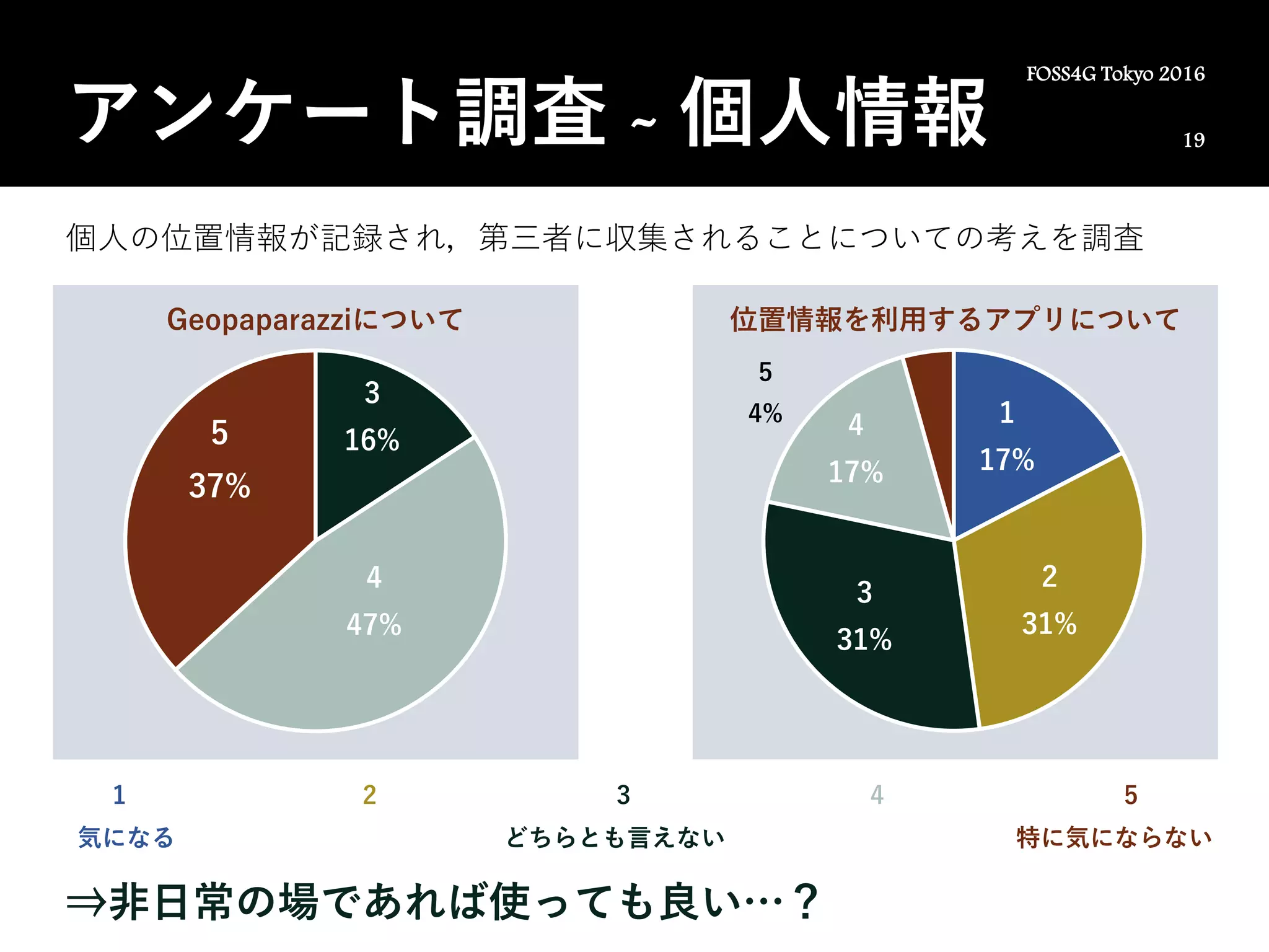
FOSS4G 2017 KYOTO.KANSAI The OSGeo foundation new initiatives and challengesOSgeo Japan
Open Source Software, Open Data and Open Standards are the three vital pillars for facilitating implementation/deployment of interoperable, scalable and sustainable geospatial infrastructure. Over the last decade, Free and Open Source Solutions for Geoinformatics (FOSS4G) has supported a variety of societal needs and gained worldwide acceptance. The Open Source Geospatial Foundation (OSGeo) has been spearheading the collaborative development of geospatial software and promote its widespread use through several initiatives and outreach activities.
This talk present about the evolution of OSGeo Foundation, its current accomplishments and avenues for future improvements. Some recent developments and opportunities for leveraging the OSGeo ecosystem for geospatial innovation will be discussed.
代表的なオープンソース空間データサーバの1つであるGeoServerは、多くの強力な機能を提供します。 特に、さまざまなデータソースからの空間データへの接続とパブリッシングをサポートします。 GeoServerはOpen Geospatial Consortiumによって地理空間フィーチャデータを要求するために設定された標準プロトコルであるWeb Feature Service(WFS)もサポートしています。 しかしながら、GeoServerは2次元ジオメトリのための関数しか提供しないため、3D空間データを処理する関数はほとんどありません。 GeoServerの重要なコンポーネントであるJTS Topology Suiteは3D空間操作をサポートしていないため、ソリッドジオメトリもサポートしていません。 この講演では、3D空間データを扱うために私たちが実装したGeoServerの拡張モジュールを紹介します。
GeoServer, one of the representative open source spatial data servers, provides many powerful features. In particular, it supports connecting to and publishing spatial data from a variety of data sources. GeoServer also supports Web Feature Service (WFS), which is a standard protocol established by the Open Geospatial Consortium to request geospatial feature data. However, GeoServer provides functions only for two-dimensional geometry, so it provides few functions for handling 3D spatial data. Because JTS Topology Suite, which is an important component of GeoServer, does not support 3D spatial operations, it also does not support solid geometries. In this talk, I will introduce extension modules of GeoServer that we have implemented to handle 3D spatial data.
Slides for the pre-event of SpaceApps Challenge Osaka (2018/09/24), describing how to find demanded open data from NASA. Be prepared for the SpaceApps Challenge 2018 Oct. 19-21. (in Japanese)
【DLゼミ】XFeat: Accelerated Features for Lightweight Image Matchingharmonylab
公開URL:https://arxiv.org/pdf/2404.19174
出典:Guilherme Potje, Felipe Cadar, Andre Araujo, Renato Martins, Erickson R. ascimento: XFeat: Accelerated Features for Lightweight Image Matching, Proceedings of the 2024 IEEE/CVF Conference on Computer Vision and Pattern Recognition (CVPR) (2023)
概要:リソース効率に優れた特徴点マッチングのための軽量なアーキテクチャ「XFeat(Accelerated Features)」を提案します。手法は、局所的な特徴点の検出、抽出、マッチングのための畳み込みニューラルネットワークの基本的な設計を再検討します。特に、リソースが限られたデバイス向けに迅速かつ堅牢なアルゴリズムが必要とされるため、解像度を可能な限り高く保ちながら、ネットワークのチャネル数を制限します。さらに、スパース下でのマッチングを選択できる設計となっており、ナビゲーションやARなどのアプリケーションに適しています。XFeatは、高速かつ同等以上の精度を実現し、一般的なラップトップのCPU上でリアルタイムで動作します。
セル生産方式におけるロボットの活用には様々な問題があるが,その一つとして 3 体以上の物体の組み立てが挙げられる.一般に,複数物体を同時に組み立てる際は,対象の部品をそれぞれロボットアームまたは治具でそれぞれ独立に保持することで組み立てを遂行すると考えられる.ただし,この方法ではロボットアームや治具を部品数と同じ数だけ必要とし,部品数が多いほどコスト面や設置スペースの関係で無駄が多くなる.この課題に対して音𣷓らは組み立て対象物に働く接触力等の解析により,治具等で固定されていない対象物が組み立て作業中に運動しにくい状態となる条件を求めた.すなわち,環境中の非把持対象物のロバスト性を考慮して,組み立て作業条件を検討している.本研究ではこの方策に基づいて,複数物体の組み立て作業を単腕マニピュレータで実行することを目的とする.このとき,対象物のロバスト性を考慮することで,仮組状態の複数物体を同時に扱う手法を提案する.作業対象としてパイプジョイントの組み立てを挙げ,簡易な道具を用いることで単腕マニピュレータで複数物体を同時に把持できることを示す.さらに,作業成功率の向上のために RGB-D カメラを用いた物体の位置検出に基づくロボット制御及び動作計画を実装する.
This paper discusses assembly operations using a single manipulator and a parallel gripper to simultaneously
grasp multiple objects and hold the group of temporarily assembled objects. Multiple robots and jigs generally operate
assembly tasks by constraining the target objects mechanically or geometrically to prevent them from moving. It is
necessary to analyze the physical interaction between the objects for such constraints to achieve the tasks with a single
gripper. In this paper, we focus on assembling pipe joints as an example and discuss constraining the motion of the
objects. Our demonstration shows that a simple tool can facilitate holding multiple objects with a single gripper.