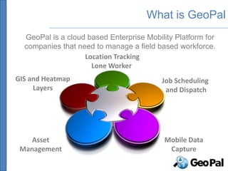
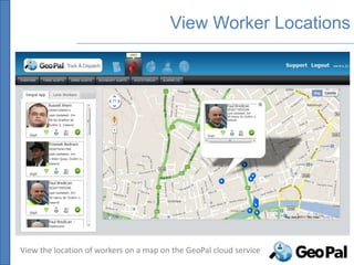
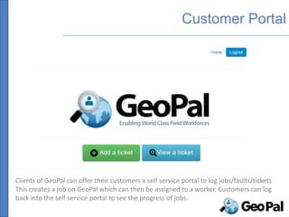
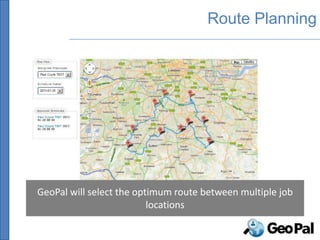
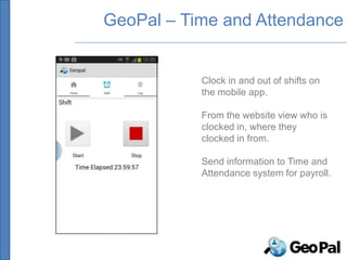
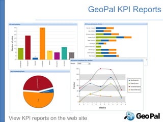
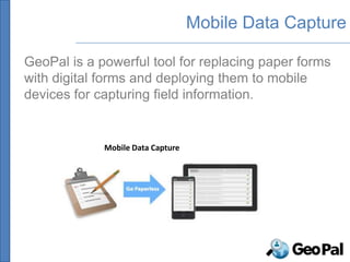
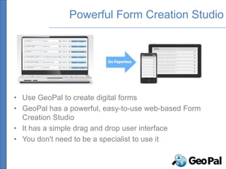
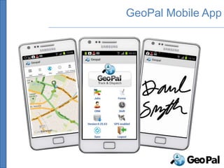
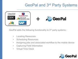
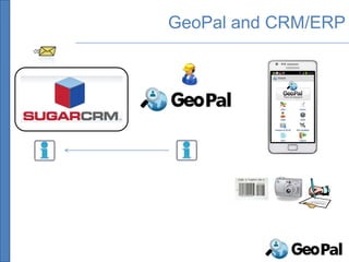
An enterprise mobility solution called GeoPal provides location tracking, job scheduling, and mobile data capture capabilities. It includes a cloud service and mobile app. The cloud service allows viewing worker locations and scheduling jobs. The mobile app allows field workers to receive job assignments, capture inspection data, and clock in/out of shifts. GeoPal integrates with CRM/ERP systems and provides benefits like increased productivity and reduced paperwork.
Introduction toArcGIS for Developers, Esri, Charles van der Put, Jim BarryEsri Nederland
This document provides an overview and agenda for the Esri Developer Summit in Europe being held on November 9, 2012 in Rotterdam. The goals of the summit are to cover ArcGIS from a developer's perspective, including what capabilities are available, how to get started, and available resources. The agenda includes discussions of ArcGIS desktop applications, geoprocessing, the geodatabase, client-server applications like ArcGIS Server and ArcGIS Online, and developer resources. It also provides overviews of ArcGIS Explorer Desktop, ArcGIS Desktop, ArcGIS Engine, geoprocessing tools, the geodatabase API, and ArcGIS web and mobile APIs.
The document provides an overview of new features in ArcGIS 10.1, including improvements to data management, mapping and visualization, geoprocessing and analysis, and GIS on the web. Key updates include enhanced feature tracking, lidar and imagery analysis tools, database management interfaces, dynamic legends, 85 new geoprocessing tools, easier workflows, and a focus on web applications using technologies like Flex, Silverlight, and JavaScript that are easier to configure and deploy. The new version also improves server performance with native 64-bit capabilities and aims to make GIS capabilities more accessible to all users.
Enhance Location-Based Insights with Additional Geocoding CapabilitiesPrecisely
Geocoding is the foundation of all location intelligence. Pinpointing the exact location of an address is the first step in uncovering what is occurring there and it’s important to understand how to leverage those insights to grow your business. As the bedrock of spatial analytics, geocodes need to be as accurate as possible to be effective.
That’s why we want you to know about the complete portfolio of geocoding solutions available from Precisely.
In addition to the accuracy and performance you have come to expect from your current product, view this on-demand webinar to learn more about new geocoding capabilities that integrate with your business processes – whether on-premises, on-demand, SaaS, API driven, or in cloud native/big data environments.
An ArcGIS portal can be implemented either through ArcGIS Online (the cloud-based version) or Portal for ArcGIS (an on-premise installation). Both provide a web-based interface for accessing and sharing enterprise mapping applications and data. The document discusses various architectures and authentication methods for setting up a portal, including using a virtual private network and integrating with Active Directory. It also outlines three approaches for using a portal: manually registering services, federating with ArcGIS Server, or designating the portal as a hosted server.
This presentation contains followings:
What is Enterprise Mobility?
Why Enterprise Mobility for your Organization?
How Enterprise Mobility increase your ROI?
Case Study
How PureLogics can help your organization?
Soa based enterprise mobility solutiontechgeneapps
This white paper discuss Enterprise mobility Trends, Design concern, Requirements, SOA based solution and Benefits of adopting SOA based enterprise mobility solution. As more and more enterprises are accepting mobility as part of their business strategy, challenges like data security, enterprise application integration and IT investment holding them back.
With SOA based enterprise mobility solution, an enterprise can easily bring mobility to their business by utilizing their existing SOA architecture with minimal changes such as, adding mobile middleware in the architecture. This solution helps enterprises in quickly setup mobility solution and address key challenges that are holding them back.
A MOBILITY SOLUTION FOR AN ENTERPRISE CUSTOMER.compressedMotasem Al Amour
This document proposes a mobility solution for an enterprise customer that uses a single wireless network SSID called "Employees" to provide different levels of access to various user groups based on their roles. Role-based access control is applied using firewall policies. Users are authenticated using 802.1X with either certificates or usernames/passwords. Device security checks are also performed. The solution provides wireless access for employees, BYOD devices, external users, barcode scanners, and guests while maintaining appropriate security measures for each group. Location-based services are also supported for indoor, home office, and on-the-road access.
El punto continuo intradérmico permite realizar una sutura sin atravesar la piel para evitar cicatrices, requiriendo una buena aproximación de los bordes de la herida sin tensión. Se realiza con material no reabsorbible introduciendo la aguja en la piel por fuera de la herida y saliendo por dentro para coser la dermis de ambos bordes de forma horizontal hasta completar la sutura.
2A2.Melocotón en almíbar. Paula L., Paola S., Raquel B.esolengua2
El documento presenta una biografía del escritor español Miguel Mihura, nacido en 1905 en Madrid. Fue autor de obras de teatro como "Tres sombreros de copa" y participó en el guión de la película "Bienvenido, Mister Marshall". Resume también la trama de su obra de teatro "Melocotones en almíbar", sobre unos atracadores que planean dos robos pero su plan se ve frustrado.
Google, Homepages und die Suche auf Arbeitgeber-Bewertungsportalen ist das eine, Social Media Kanäle nach Wording, Beiträgen, Spots, Blogs zu durchforsten die andere Möglichkeit; Social Networking als “Beziehungspflege“ die jüngste. „Tue Gutes und rede darüber“, soll Appetit aufs Arbeiten im Unternehmen XY machen. Längst haben die Unternehmen erkannt, dass es nicht nur um das Vermarkten von Produktvorteilen geht, sondern auch um den Aufbau Ihrer Marke als Arbeitgeber.
The RSHP Gala Ball was a fantastic successful charity ball to celebrate RSHP\'s 30th anniversary year. The ball raised £25,000 for RSHP, a local independent homeless charity in Reading
Este documento resume las sanciones disciplinarias impuestas por el Subcomité Regional de Competición de Fútbol Aficionado y Juvenil a jugadores y clubes por infracciones cometidas en partidos de la Primera Autonómica de Galicia. Se detallan los nombres de los sancionados, los clubes a los que pertenecen, los motivos de la sanción de acuerdo con los artículos del reglamento y las penas impuestas en cada caso. También se informa sobre la suspensión de dos partidos por condiciones climatoló
Emergya Posicionamiento Seo Jornadas Turismo - Nacho MontoyaNacho Montoya
Este documento describe cómo las empresas de turismo rural pueden aumentar las reservas y los ingresos a través de Internet. Explica que Internet es el mayor centro comercial del mundo y que hay infinitas oportunidades para que las empresas tengan su escaparate en línea. Sin embargo, tener presencia en Internet no es suficiente, las empresas también deben posicionarse de manera efectiva en los motores de búsqueda a través de técnicas de posicionamiento como el uso de palabras clave relevantes y la obtención de enlaces entrantes de alta calidad. El document
Este documento describe las diferentes etapas del proceso electoral en Ecuador, incluyendo la etapa pre-electoral, electoral y post-electoral. Detalla los roles y responsabilidades de los delegados políticos, observadores y miembros de las juntas receptoras del voto durante cada etapa. También explica los recursos y acciones legales que pueden interponerse ante el Consejo Nacional Electoral y el Tribunal Contencioso Electoral.
Ponencia de Manuel Garoña del Ayuntamiento de Sevilla dentro del seminario "Smart Cities y Smart Destinations en el marco de Internet del Futuro" organizada por Prodigy Consultores el día 17/12/2013 en el ParcBit de Palma de Mallorca con el apoyo de la Smart Office del Ayuntamiento de Palma de Mallorca y con la colaboración del Ministerio de Industria, Energía y Turismo, la Plataforma Tecnológica Española de Convergencia hacia Internet del Futuro (es.INTERNET) y el ParcBit.
Una red de computadoras conecta equipos a través de cables, señales u ondas para compartir información y recursos. Existen diferentes tipos de redes clasificadas por su alcance, método de conexión, topología y direccionalidad de los datos. Los computadores se comunican a través de direcciones IP únicas asignadas a cada interfaz de red, permitiendo el envío y recepción de información a través de la red.
Informes de Evaluación de Tecnologías Sanitarias.
Ministerio de Sanidad, Servicios Sociales e Igualdad.
Red Española de Agencias de Evaluación de Tecnologías y Presataciones del Sistema Nacional de Salud.
Instituto Aragonés de Ciencias de la Salud.
Reseña histórica de la UNP de Manta 50 o el desafío de la comunicación mana...Sanchez Joselias
Un esbozo histórico que recupera la memoria institucional de la Unión Nacional de Periodistas, núcleo de Manta, desde su conformación en 1966 revisando tres períodos destacados como nacimiento, consolidación y proyección, hasta sus 50 años.
Este documento resume un caso de neoplasia gestacional en una paciente de 27 años. Presentaba síntomas de vómito y malestar general. Las pruebas mostraron cifras elevadas de BHCG y ecografía compatible con embarazo molar. Fue sometida a curetaje. Luego desarrolló síntomas de sangrado y presión alta, diagnosticándose neoplasia trofoblástica gestacional. Requirió tratamiento y finalmente histerectomía.
Customisable Mobile Workforce Management SolutionsGeoPal Solutions
This document discusses GeoPal, a cloud-based mobile workforce management service. GeoPal allows companies to manage mobile workforces through customizable mobile forms, mapping and location services, and real-time reporting. It provides scheduling, dispatching, and data collection capabilities to increase productivity and reduce costs. GeoPal can be used across various industries like facilities management, healthcare, and utilities. It integrates a mobile app for field workers and a web management system for administrators to streamline operations.
Finding the right way to manage your field operations and field workers can be challenging.
GeoPal provides a Platform Solution that works for both managers and workers alike.
NYC Parks, a Mobile Computing Agency (Peter Carlo)geeknixta
NYC Parks and Recreation (DPR) has transitioned to using mobile computing devices for its field staff. DPR has purchased over 1100 mobile devices in the past 18 months to replace outdated paper-based systems. These devices allow staff to access legacy applications, off-the-shelf software, and custom-built mobile apps from the field. One such app is the Forestry Storm Mobile app, which uses GPS and GIS services to help staff map and inspect trees after storms. DPR aims to develop more mobile apps that minimize steps, support multiple workflows, and take advantage of services from other city agencies.
TELUS Case Study: iVAULT implementation improved corporate intelligence eventspat
This document summarizes a webinar about TELUS's implementation of the iVAULT content management system. Some key points:
- iVAULT was implemented to improve TELUS's corporate intelligence by creating a centralized spatial data store and new FieldView application. This consolidated data from disparate legacy systems and maps like ArcGIS, MapGuide, and Google Maps.
- The new architecture included an Oracle spatial data store replicating TELUS infrastructure data from their Intergraph Framme system. This cleaned up issues and standardized the data.
- A new FieldView application was developed to provide customized analysis tools for various departments through a web interface on both desktop and mobile.
- The
TELUS Case Study: GIS for Telecommunicationseventspat
This document describes how TELUS implemented an iVAULT system to improve access to and use of their spatial data. Key points:
1. TELUS integrated their disparate GIS systems and data into a single iVAULT system with a spatial data store, allowing unified access for field users and departments.
2. The iVAULT system included a new FieldView application for viewing, searching, analyzing and editing spatial and attribute data via web and mobile.
3. The spatial data store cleaned up TELUS' IMAGE database and consolidated over 1,000 design files, improving data quality and access.
4. The unified system allows TELUS to better analyze customer and network data
Putting Asset Management Tools on the web and mobile devices with Cartegraph ...GeCo in the Rockies
1) The City of Golden implemented an online and mobile asset management system using Cartegraph and GIS to increase accessibility and efficiency of their asset data.
2) This allows staff to access up-to-date asset information and complete work orders from mobile devices in the field.
3) The system integrates asset and spatial data, enables real-time progress monitoring, and improved citizen request management through a web portal.
This document introduces Geo Nuris, an enterprise GIS software developed by CCI Co., Ltd. It consists of Geo Nuris products like the web server, spatial server, and desktop pro. The benefits highlighted are that it is OGC certified, supports multiple GIS databases and formats, and has high performance. Examples shown include searching poles in the electric package, underground switch editing with map mashups, substation selection and feeder tracing with thematic maps, and automatic schematics diagram generation. Case studies demonstrated include KEPCO smart grid applications and a BI web dashboard.
Adding Location and Geospatial Analytics to Big Data Analytics (BDT210) | AWS...Amazon Web Services
(Presented by Esri)
When people analyze a problem, they often include location at the core of the analysis. Location and spatial context, combined with geographical knowledge, can make the biggest difference in understanding a problem and analyzing it in a more meaningful way.
In this session, we show how Amazon EMR can be used with location and geospatial analytics, and how the Amazon EMR API and the Python SDK were used to build tools that integrate Big Data and geospatial analysis. We also show powerful visualization options for displaying your results, using maps which can be shared in reports or distributed online and to mobile apps.
Immersive Learning for Tunnelling and Highways #COMIT2019Comit Projects Ltd
Presentation by Dan Riley, Spearhead Interactive and Safespace VR at the 2019 COMIT Conference. More information: http://www.comit.org.uk/conference-2019
GWT 2014: Emergency Conference - 02 le soluzioni geospaziali per la gestione ...Planetek Italia Srl
Geospatial World Tour 2014: Emergency Conference.
Napoli, 28 maggio 2014.
Le soluzioni Geospaziali per la gestione delle emergenze.
Simone Colla, Hexagon Geospatial
Presentations from IMGS at Local Government User Group session on 11/09/2012.
Includes presentations on Location Publisher updates, GeoMedia Smartclient, Leica Geosystems and ERDAS Imagine and Apollo
GeoCollector for ArcPad is a mobile GIS solution that combines Esri's ArcPad software with Trimble GPS hardware to improve the accuracy of collected location data. It provides field workers with a rugged tablet equipped with an integrated GPS receiver and ArcPad software for mapping and data collection. This solution allows organizations to make timely decisions based on reliable location information gathered by field staff.
This document discusses using Collector for ArcGIS to enable field data collection and empower utility operations. Collector allows users to collect data using mobile devices and publish it to ArcGIS Online or Portal for use across the organization. While Collector currently only supports connected access, Esri is working on offline support which is not yet suitable for most utility workflows due to limitations like an inability to use dynamic map services. The document provides recommendations for implementing Collector, including publishing editable feature services and creating web maps for use in the app.
This document provides an outline for training on using mobile apps for ArcGIS for data preparation, processing, and field collection. It covers preparing and publishing data to ArcGIS Online, configuring projects in Collector and forms in Survey123, collecting and syncing data in the field apps, and exporting data. Specific topics include geodatabase and map document creation, publishing feature services, configuring apps in AGOL, using Collector and Survey123 for data collection on points, polygons and lines, and considerations for location services and GPS on mobile devices.
Deep Dive into the ArcGIS Geotrigger Service - Esri DevSummit Dubai 2013Aaron Parecki
This document provides an overview of the ArcGIS Geotrigger service, which allows mobile applications to send push notifications to users when they enter or leave geographic areas. It discusses how to set up triggers using the Geotrigger API or visual editor, and how triggers can send notifications, call web hooks, or change a user's tracking profile. It also covers differences in how location services work on iOS and Android, considerations for battery life, and getting started with the Geotrigger SDKs.
We NSG India, a ESRI Gold Partner, have been working with many companies on a collaborative mode and delivering solutions on ESRI platform configured to their businesses.
NSG has global presence in India, UAE, NewZealand, United states and we offer services in the following ESRI and Microsoft technology areas: NSGI has a special focus on application development, geo-database implementation and web deployment. We develop applications across the entire ESRI suite of products – from ArcPad to ArcGIS Server and ArcGIS Online,
ArcFM Desktop and ArcFM Server based application customisation using.NET, Java using SQL Server and Oracle spatial databases.
We are ESRI-Centric working on Strategic GIS Consulting, Enterprise GIS Implementations catering to specific vertical markets and domains like Ports, Building Inspection Management and Citizen centric incident and complaints management system for Local Government (Municipal Councils, Counties), Climate Change, Marine, Utilities and Spatial Data Infrastructure.
We have expertise in small to medium to large scale ESRI and Microsoft Based projects. We specialize in offshore-based application development & have proven track record in providing turnkey solution to GIS Companies and Governments. We provide offshore technical and development support on Geocortex Spatial application infrastructure with future proof technologies with minimum custom code requirements. Our offshore development model has a proven cost saving and enable the organization to:
1. Create GIS applications that meet the demand for maps and applications for administrators and project stakeholders;
2. Provide end-users with simple and repeatable processes for accessing information, inside applications tailored to their needs.
3. Reduce the cost of development, support, maintaining/administering applications.
4. Share geospatial information with internal or external stakeholders on an array of desktop/mobile devices.
I have also attached a brief presentation on our corporate background and service capabilities. If you need any additional information or have a query, please do feel free to contact us.
Forcelink is a mobile workforce management software that allows organizations to electronically issue work to field staff and receive updates. It increases productivity, improves cash flow and customer service, and reduces costs and administration. Key benefits include real-time status updates, accurate reporting, and high configurability. Forcelink operates on various mobile devices and integrates with other systems. Case studies demonstrate benefits for security, utility, and IT companies.
2012 GISCO Track, Emerging Technologies for Field Data Capture, Bill TimminsGIS in the Rockies
Mobile GIS solutions that are easy to use and inexpensive can enable field personnel to access and input geospatial data, eliminating technology barriers. These solutions allow for field data capture, review capabilities, and interactive comments. They provide intra-agency and inter-agency coordination to support workflow requirements and understanding of roles. Examples include using digital pens and GPS-enabled cameras on Android devices to create and collect geospatial features and forms for vulnerability assessments. The captured data can then be shared to facilitate collaboration and situational awareness.
The Genesis of BriansClub.cm Famous Dark WEb PlatformSabaaSudozai
BriansClub.cm, a famous platform on the dark web, has become one of the most infamous carding marketplaces, specializing in the sale of stolen credit card data.
At Techbox Square, in Singapore, we're not just creative web designers and developers, we're the driving force behind your brand identity. Contact us today.
The 10 Most Influential Leaders Guiding Corporate Evolution, 2024.pdfthesiliconleaders
In the recent edition, The 10 Most Influential Leaders Guiding Corporate Evolution, 2024, The Silicon Leaders magazine gladly features Dejan Štancer, President of the Global Chamber of Business Leaders (GCBL), along with other leaders.
Brian Fitzsimmons on the Business Strategy and Content Flywheel of Barstool S...Neil Horowitz
On episode 272 of the Digital and Social Media Sports Podcast, Neil chatted with Brian Fitzsimmons, Director of Licensing and Business Development for Barstool Sports.
What follows is a collection of snippets from the podcast. To hear the full interview and more, check out the podcast on all podcast platforms and at www.dsmsports.net
Storytelling is an incredibly valuable tool to share data and information. To get the most impact from stories there are a number of key ingredients. These are based on science and human nature. Using these elements in a story you can deliver information impactfully, ensure action and drive change.
Building Your Employer Brand with Social MediaLuanWise
Presented at The Global HR Summit, 6th June 2024
In this keynote, Luan Wise will provide invaluable insights to elevate your employer brand on social media platforms including LinkedIn, Facebook, Instagram, X (formerly Twitter) and TikTok. You'll learn how compelling content can authentically showcase your company culture, values, and employee experiences to support your talent acquisition and retention objectives. Additionally, you'll understand the power of employee advocacy to amplify reach and engagement – helping to position your organization as an employer of choice in today's competitive talent landscape.
Digital Marketing with a Focus on Sustainabilitysssourabhsharma
Digital Marketing best practices including influencer marketing, content creators, and omnichannel marketing for Sustainable Brands at the Sustainable Cosmetics Summit 2024 in New York
Navigating the world of forex trading can be challenging, especially for beginners. To help you make an informed decision, we have comprehensively compared the best forex brokers in India for 2024. This article, reviewed by Top Forex Brokers Review, will cover featured award winners, the best forex brokers, featured offers, the best copy trading platforms, the best forex brokers for beginners, the best MetaTrader brokers, and recently updated reviews. We will focus on FP Markets, Black Bull, EightCap, IC Markets, and Octa.
How MJ Global Leads the Packaging Industry.pdfMJ Global
MJ Global's success in staying ahead of the curve in the packaging industry is a testament to its dedication to innovation, sustainability, and customer-centricity. By embracing technological advancements, leading in eco-friendly solutions, collaborating with industry leaders, and adapting to evolving consumer preferences, MJ Global continues to set new standards in the packaging sector.
[To download this presentation, visit:
https://www.oeconsulting.com.sg/training-presentations]
This presentation is a curated compilation of PowerPoint diagrams and templates designed to illustrate 20 different digital transformation frameworks and models. These frameworks are based on recent industry trends and best practices, ensuring that the content remains relevant and up-to-date.
Key highlights include Microsoft's Digital Transformation Framework, which focuses on driving innovation and efficiency, and McKinsey's Ten Guiding Principles, which provide strategic insights for successful digital transformation. Additionally, Forrester's framework emphasizes enhancing customer experiences and modernizing IT infrastructure, while IDC's MaturityScape helps assess and develop organizational digital maturity. MIT's framework explores cutting-edge strategies for achieving digital success.
These materials are perfect for enhancing your business or classroom presentations, offering visual aids to supplement your insights. Please note that while comprehensive, these slides are intended as supplementary resources and may not be complete for standalone instructional purposes.
Frameworks/Models included:
Microsoft’s Digital Transformation Framework
McKinsey’s Ten Guiding Principles of Digital Transformation
Forrester’s Digital Transformation Framework
IDC’s Digital Transformation MaturityScape
MIT’s Digital Transformation Framework
Gartner’s Digital Transformation Framework
Accenture’s Digital Strategy & Enterprise Frameworks
Deloitte’s Digital Industrial Transformation Framework
Capgemini’s Digital Transformation Framework
PwC’s Digital Transformation Framework
Cisco’s Digital Transformation Framework
Cognizant’s Digital Transformation Framework
DXC Technology’s Digital Transformation Framework
The BCG Strategy Palette
McKinsey’s Digital Transformation Framework
Digital Transformation Compass
Four Levels of Digital Maturity
Design Thinking Framework
Business Model Canvas
Customer Journey Map
B2B payments are rapidly changing. Find out the 5 key questions you need to be asking yourself to be sure you are mastering B2B payments today. Learn more at www.BlueSnap.com.
HOW TO START UP A COMPANY A STEP-BY-STEP GUIDE.pdf46adnanshahzad
How to Start Up a Company: A Step-by-Step Guide Starting a company is an exciting adventure that combines creativity, strategy, and hard work. It can seem overwhelming at first, but with the right guidance, anyone can transform a great idea into a successful business. Let's dive into how to start up a company, from the initial spark of an idea to securing funding and launching your startup.
Introduction
Have you ever dreamed of turning your innovative idea into a thriving business? Starting a company involves numerous steps and decisions, but don't worry—we're here to help. Whether you're exploring how to start a startup company or wondering how to start up a small business, this guide will walk you through the process, step by step.
The APCO Geopolitical Radar - Q3 2024 The Global Operating Environment for Bu...APCO
The Radar reflects input from APCO’s teams located around the world. It distils a host of interconnected events and trends into insights to inform operational and strategic decisions. Issues covered in this edition include:
Company Valuation webinar series - Tuesday, 4 June 2024FelixPerez547899
This session provided an update as to the latest valuation data in the UK and then delved into a discussion on the upcoming election and the impacts on valuation. We finished, as always with a Q&A
2. What is GeoPal
GeoPal is a cloud based Enterprise Mobility Platform for
companies that need to manage a field based workforce.
Location Tracking
Lone Worker
GIS and Heatmap Job Scheduling
Layers and Dispatch
Asset Mobile Data
Management Capture
3. What is GeoPal
Location Tracking
Lone Worker
GIS and Heatmap Job Scheduling
Layers and Dispatch
Asset Mobile Data
Management Capture
4. What is GeoPal
There are two parts to GeoPal – a cloud service and a
mobile application :
GeoPal cloud service GeoPal Mobile app
GeoPal provides a communication channel between the back office and field workers :
From the office to the field -> job schedules and workflows, customer details, Service Level
Agreements, GIS information, route plans and directions, asset details, files and images.
From the field to the office -> accurate and timely job reports, inspection and survey
results, shift details, photographs, signatures, bar code scans, updated customer and asset
details, GPS coordinates and annotated drawings and images.
5. Needs we are addressing
• Better management visibility of activity in the field
• Ability to transfer information between the back office and the
front lines
• Ability to schedule jobs and dispatch them to workers in the field
• Receive accurate and timely job reports from the field
• Elimination of paper processes and associated admin costs
• Provide a mobility plug-in for existing office CRM / ERP / Work
order management systems
• Reduce time from work done to issuing invoice
• Increase customer satisfaction
6. Value Proposition
Increase field worker productivity by 20%
through better job scheduling and reduce
administration costs by 50% by eliminating
paperwork
9. Lone Worker Protection
GeoPal mobile app has features for Lone Worker protection
-Location : View real-time location of field workers.
- Regular Check-in : Worker prompted to check-in to app at regular intervals.
Alarm raised if check-in missed. Alert email and sms sent to designated list.
- Non movement alarm : The GeoPal app can raise an alarm when non-movement
detected. Local alarm on mobile device first, which can be reset. If not reset,
alarm raised to designated list.
- Fall detection : The GeoPal app can raise an alarm on detecting a fall using
accelerometers in the device.
- Panic Alarm : User can swipe an RFID fob across the phone to raise an alarm.
11. Scheduling Jobs
• Add a Job
• Drag and drop the Job onto the worker on the timeline chart
• See the status of the Job on the timeline chart
12. Drag and Drop scheduling
• Assigning jobs is easy
• Drag and drop the Job onto the worker on the timeline
chart
13. View New Jobs
New jobs are automatically
sent to the workers mobile
device
14. View Job Location
The worker clicks on the
GPS Coordinates to view
the job Location and get
turn by turn directions
1
2
15. Customer Portal
Clients of GeoPal can offer their customers a self service portal to log jobs/faults/tickets
This creates a job on GeoPal which can then be assigned to a worker. Customers can log
back into the self service portal to see the progress of jobs.
17. GeoPal – Time and Attendance
Clock in and out of shifts on
the mobile app.
From the website view who is
clocked in, where they
clocked in from.
Send information to Time and
Attendance system for payroll.
20. Mobile Data Capture
GeoPal is a powerful tool for replacing paper forms
with digital forms and deploying them to mobile
devices for capturing field information.
Mobile Data Capture
21. Powerful Form Creation Studio
• Use GeoPal to create digital forms
• GeoPal has a powerful, easy-to-use web-based Form
Creation Studio
• It has a simple drag and drop user interface
• You don't need to be a specialist to use it
23. Field Information Capture
The mobile forms can include any combination of the
following steps :
• Photographs • Videos
• Signatures • Sketches
• GPS Coordinates • Text notes
• Lists : single/multiple • Scan bar codes
choice • Scan RFID tags
• Voice Notes
28. Capture Asset Details – Inventory Audit
Capture Inspect /service Select
Use the mobile app to capture asset details :
• Asset ID
• Make / Model / Serial No.
• Barcode / RFID Tag
• GPS Location
• Photograph
• Next inspection due date
• Condition
• etc
29. Inspect Assets
Capture Inspect /service Select
GeoPal can trigger inspection jobs based on service dates :
• Scan RFID tag on asset
• Confirm correct asset
• Confirm asset location
• Perform inspection
• Note inspection results
• Insert next inspection due
date
30. Select Assets
Capture Inspect /service Select
Select materials used on a job from asset list :
• Select part used
• Automatically inserts part
Make / Model / Serial No.
into job report
• Automatically create
invoice
35. GeoPal and 3rd Party Systems
CRM/ERP
+
GeoPal adds the following functionality to 3rd party systems :
• Locating Resources
• Scheduling Resources
• Assigning jobs and associated workflow to the mobile device
• Capturing Field Information
• Virtual Time Clock
38. Security
GeoPal
128 bit SSL
VPN
WWW
128 bit SSL
128 bit SSL
VPN
Remote User
• Password protected login
• No auto login in facility
• Inherent password protection on device
• Optional auto-log out on inactivity
• 128bit encryption of Data on device
Office User
39. GeoPal Infrastructure - Hosted on Amazon AWS
Internet
Zone 1 Zone 2
Load Balancer
Application Servers
EC2
EC2 EC2
EC2
S3
S3 S3 – Customer
accessible
content servers
Relational Databases RDS RDS
41. Benefits to your Business
Extra jobs completed: 25% Faster Invoicing - Immediate
Better customer service. 100%
Reduce overtime: 15%+
online access to all data
Field worker acceptance: 100%
Reduce admin: 50%+
Increased productivity: 28%
Elimination of paper work: 100%
Reduce Vehicle Usage with Track and exceed KPIs / SLAs
better scheduling
Real Time analysis and 10 Times Return on Investment
statistics
42. GeoPal Pricing
GeoPal Pricing
€300 per month for up to 10 users
€30 per additional user per month
Once off cost of €900 for setup and training
No software to install on office computers.
Download the free GeoPal mobile app from the app store
Free Trial – we offer a free trial of GeoPal for a month, so that you
can see if GeoPal is the right solution for you.