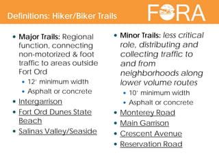
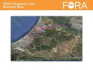
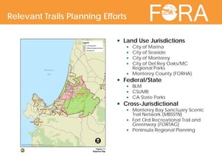
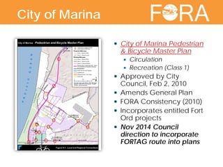
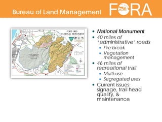
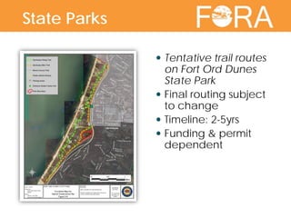
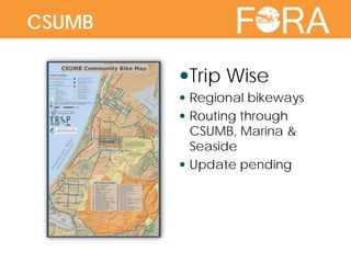
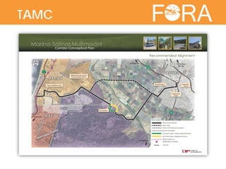
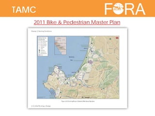
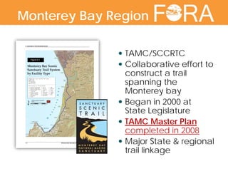
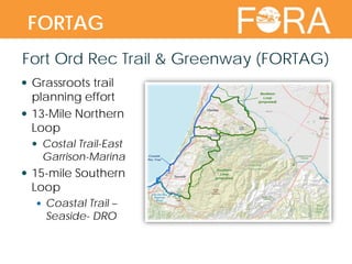
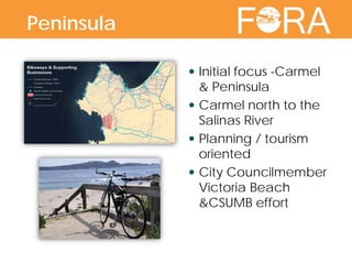
Josh Metz
Senior Planner
Fort Ord Trails: Reuse Plan &
Regional Context
 Definitions
 Economics
 Reuse Plan Context
 FORA Jurisdictions
 Regional Entities
 Opportunity
Overview
 “Trails” –variety of
meanings
 For this effort: A trail is a
passage way or
designated route for
pedestrian, bicycle,
equestrian, and/or
other non-vehicular
use. Includes paved,
unpaved, urban, &
rural routes. Requires
entity maintenance &
liability coverage.
Definitions
 Economic recovery
integral FORA mission
 Trail/active transit
infrastructure
opportunity
 Health & Wellness
 Tourism
 Civic Amenity
 New Business
Economics
 Provide connections to non-motorized transportation
alternatives to all neighborhoods
 Use recreation and open space assets to make the
former Fort Ord attractive to potential users by
interconnecting and increasing access
 Adequate ROW should be reserved along
planned transportation corridors
 The Fort Ord trails system shall be considered as an
integral part of a larger regional trails network and
shall be linked to regional bike/pedestrian trails
wherever possible
*Reuse Plan V1 Context & Framework: Section 3.6 Conservation, Open Space, and Recreation Concept
Reuse Plan Trail Principles*
BRP Open Space &
Recreation Framework
 Major Trails: Regional
function, connecting
non-motorized & foot
traffic to areas outside
Fort Ord
 12’ minimum width
 Asphalt or concrete
 Intergarrison
 Fort Ord Dunes State
Beach
 Salinas Valley/Seaside
 Minor Trails: less critical
role, distributing and
collecting traffic to
and from
neighborhoods along
lower volume routes
 10’ minimum width
 Asphalt or concrete
 Monterey Road
 Main Garrison
 Crescent Avenue
 Reservation Road
Definitions: Hiker/Biker Trails
DRAFT Regional Trail
Network Map
 Land Use Jurisdictions
 City of Marina
 City of Seaside
 City of Monterey
 City of Del Rey Oaks/MC
Regional Parks
 Monterey County (FORHA)
 Federal/State
 BLM
 CSUMB
 CA State Parks
 Cross-Jurisdictional
 Monterey Bay Sanctuary Scenic
Trail Network (MBSSTN)
 Fort Ord Recreational Trail and
Greenway (FORTAG)
 Peninsula Regional Planning
Relevant Trails Planning Efforts
 City of Marina Pedestrian
& Bicycle Master Plan
 Circulation
 Recreation (Class 1)
 Approved by City
Council, Feb 2, 2010
 Amends General Plan
 FORA Consistency (2010)
 Incorporates entitled Fort
Ord projects
 Nov 2014 Council
direction to incorporate
FORTAG route into plans
City of Marina
City of Seaside  Existing bikeways map
in Seaside General Plan
 General Plan Update
underway
 Circulation
 Recreation
 FORA Consistency
(2004)
 Identifies bike routes
throughout city
 Links to CSUMB and
Coastal Trail
City of Seaside
Monterey on the
Move
 Multi-modal
Transportation Plan
 Circulation
 Recreation
 Adopted by City
Council 3/19/13
 Bike / Pedestrian
focus
City of Monterey
 Preliminary Frog
Pond concept work
in Del Rey Oaks
 Future collaboration
between City,
developers & trail
advocates
City of Del Rey Oaks
Monterey CountyFort Ord Recreational Habitat Area Master Plan
Monterey County
 National Monument
 40 miles of
“administrative” roads
 Fire break
 Vegetation
management
 46 miles of
recreational trail
 Multi-use
 Segregated uses
 Current issues:
signage, trail head
quality, &
maintenance
Bureau of Land Management
 Tentative trail routes
on Fort Ord Dunes
State Park
 Final routing subject
to change
 Timeline: 2-5yrs
 Funding & permit
dependent
State Parks
 CSUMB Master Plan
 Pedestrian / bicycle
focus
 Preliminary trail
concept under
development
 Connecting students
to:
 Fort Ord Dunes State Park
 East Campus Housing
 National Monument
CSUMB
Trip Wise
 Regional bikeways
 Routing through
CSUMB, Marina &
Seaside
 Update pending
CSUMB
TAMC
TAMC
2011 Bike & Pedestrian Master Plan
 TAMC/SCCRTC
 Collaborative effort to
construct a trail
spanning the
Monterey bay
 Began in 2000 at
State Legislature
 TAMC Master Plan
completed in 2008
 Major State & regional
trail linkage
Monterey Bay Region
Fort Ord Rec Trail & Greenway (FORTAG)
 Grassroots trail
planning effort
 13-Mile Northern
Loop
 Costal Trail-East
Garrison-Marina
 15-mile Southern
Loop
 Coastal Trail –
Seaside- DRO
FORTAG
Peninsula Regional trail connections Initial focus -Carmel
& Peninsula
 Carmel north to the
Salinas River
 Planning / tourism
oriented
 City Councilmember
Victoria Beach
&CSUMB effort
Peninsula
Peninsula Regional trail connections Understand value of
connected active
transit system
 Global best
practices
 Coordination
between agencies,
users & advocates
 Bring enthusiasm to
Design Charrette
Opportunity

FortOrdTrailsSymposium_Background-RegionalContext_021915

  • 1.
    Josh Metz Senior Planner FortOrd Trails: Reuse Plan & Regional Context
  • 2.
     Definitions  Economics Reuse Plan Context  FORA Jurisdictions  Regional Entities  Opportunity Overview
  • 3.
     “Trails” –varietyof meanings  For this effort: A trail is a passage way or designated route for pedestrian, bicycle, equestrian, and/or other non-vehicular use. Includes paved, unpaved, urban, & rural routes. Requires entity maintenance & liability coverage. Definitions
  • 4.
     Economic recovery integralFORA mission  Trail/active transit infrastructure opportunity  Health & Wellness  Tourism  Civic Amenity  New Business Economics
  • 5.
     Provide connectionsto non-motorized transportation alternatives to all neighborhoods  Use recreation and open space assets to make the former Fort Ord attractive to potential users by interconnecting and increasing access  Adequate ROW should be reserved along planned transportation corridors  The Fort Ord trails system shall be considered as an integral part of a larger regional trails network and shall be linked to regional bike/pedestrian trails wherever possible *Reuse Plan V1 Context & Framework: Section 3.6 Conservation, Open Space, and Recreation Concept Reuse Plan Trail Principles*
  • 6.
    BRP Open Space& Recreation Framework
  • 7.
     Major Trails:Regional function, connecting non-motorized & foot traffic to areas outside Fort Ord  12’ minimum width  Asphalt or concrete  Intergarrison  Fort Ord Dunes State Beach  Salinas Valley/Seaside  Minor Trails: less critical role, distributing and collecting traffic to and from neighborhoods along lower volume routes  10’ minimum width  Asphalt or concrete  Monterey Road  Main Garrison  Crescent Avenue  Reservation Road Definitions: Hiker/Biker Trails
  • 8.
  • 9.
     Land UseJurisdictions  City of Marina  City of Seaside  City of Monterey  City of Del Rey Oaks/MC Regional Parks  Monterey County (FORHA)  Federal/State  BLM  CSUMB  CA State Parks  Cross-Jurisdictional  Monterey Bay Sanctuary Scenic Trail Network (MBSSTN)  Fort Ord Recreational Trail and Greenway (FORTAG)  Peninsula Regional Planning Relevant Trails Planning Efforts
  • 10.
     City ofMarina Pedestrian & Bicycle Master Plan  Circulation  Recreation (Class 1)  Approved by City Council, Feb 2, 2010  Amends General Plan  FORA Consistency (2010)  Incorporates entitled Fort Ord projects  Nov 2014 Council direction to incorporate FORTAG route into plans City of Marina
  • 11.
    City of Seaside Existing bikeways map in Seaside General Plan  General Plan Update underway  Circulation  Recreation  FORA Consistency (2004)  Identifies bike routes throughout city  Links to CSUMB and Coastal Trail City of Seaside
  • 12.
    Monterey on the Move Multi-modal Transportation Plan  Circulation  Recreation  Adopted by City Council 3/19/13  Bike / Pedestrian focus City of Monterey
  • 13.
     Preliminary Frog Pondconcept work in Del Rey Oaks  Future collaboration between City, developers & trail advocates City of Del Rey Oaks
  • 14.
    Monterey CountyFort OrdRecreational Habitat Area Master Plan Monterey County
  • 15.
     National Monument 40 miles of “administrative” roads  Fire break  Vegetation management  46 miles of recreational trail  Multi-use  Segregated uses  Current issues: signage, trail head quality, & maintenance Bureau of Land Management
  • 16.
     Tentative trailroutes on Fort Ord Dunes State Park  Final routing subject to change  Timeline: 2-5yrs  Funding & permit dependent State Parks
  • 17.
     CSUMB MasterPlan  Pedestrian / bicycle focus  Preliminary trail concept under development  Connecting students to:  Fort Ord Dunes State Park  East Campus Housing  National Monument CSUMB
  • 18.
    Trip Wise  Regionalbikeways  Routing through CSUMB, Marina & Seaside  Update pending CSUMB
  • 19.
  • 20.
    TAMC 2011 Bike &Pedestrian Master Plan
  • 21.
     TAMC/SCCRTC  Collaborativeeffort to construct a trail spanning the Monterey bay  Began in 2000 at State Legislature  TAMC Master Plan completed in 2008  Major State & regional trail linkage Monterey Bay Region
  • 22.
    Fort Ord RecTrail & Greenway (FORTAG)  Grassroots trail planning effort  13-Mile Northern Loop  Costal Trail-East Garrison-Marina  15-mile Southern Loop  Coastal Trail – Seaside- DRO FORTAG
  • 23.
    Peninsula Regional trailconnections Initial focus -Carmel & Peninsula  Carmel north to the Salinas River  Planning / tourism oriented  City Councilmember Victoria Beach &CSUMB effort Peninsula
  • 24.
    Peninsula Regional trailconnections Understand value of connected active transit system  Global best practices  Coordination between agencies, users & advocates  Bring enthusiasm to Design Charrette Opportunity