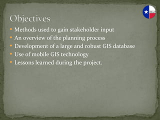
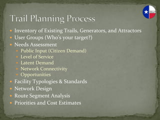
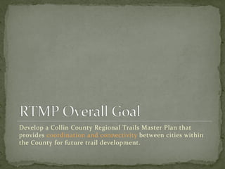
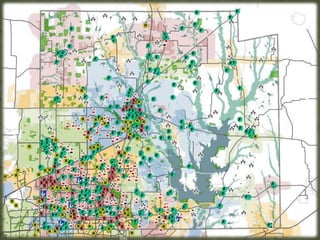
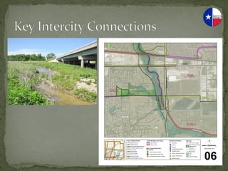
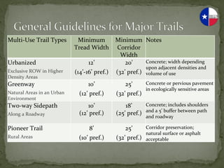
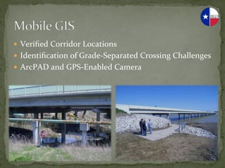
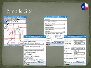
This document summarizes a collaborative multi-jurisdictional planning effort to develop a regional trails master plan for Collin County, Texas. It describes the planning process, which included gathering stakeholder input, developing a GIS database, and identifying existing trails, generators, and attractors. The plan aims to provide trail connectivity between cities in Collin County and recommend priorities and cost estimates to guide future trail development.
The Major and Collector Street Plan (MCSP) is a comprehensive plan and implementation tool for guiding public and private investment in the major streets (Arterial-Boulevards, Arterial- Parkways and Collector-Avenues) that make up the backbone of the city’s transportation system.
Tysons Status Report: Board of Supervisors Community Revitalization and Reinv...Fairfax County
On April 12, 2011, Fairfax County staff presented a Tysons Status Report (PDF) to the Board. The presentation includes an overview of the rezoning applications that have been submitted to date within Tysons and the status of the 20 Follow-on Motions that the Board made when it adopted the Tysons Plan on June 22, 2010.
The Long-Range Transit Plan (LRTP) is a comprehensive strategy for enhancing significantly the public transit system for the central Ohio region over the next 23 years. Utilizing a variety of methods to ensure public participation, the LRTP has been developed to respond to the growing transportation needs of the central Ohio region by providing an expanded, reliable, and safe transit system. In every major metropolitan area, investments in the transportation infrastructure, including public transit, is vital for ensuring economic vitality and improved quality of life.
2013 GISCO Track, Regional Centerline Integration on the Colorado Front Range...GIS in the Rockies
For the past four years, initially under the auspices of the DRCOG Regional Datasharing Consortium and, more recently, the Colorado Homeland Security North Central Region, progress has been made at edge matching street centerlines throughout the North Front Range area. Thirteen Counties and fifteen Cities – basically all jurisdictions that have digital centerline layers – have worked on this project. The product is a set of agreement points covering every location where a public road crosses a jurisdictional boundary.
The first phase, recently completed, focused on County boundaries. The second phase, still in progress, focused on City-City and City-Unincorporated boundaries away from the county borders. When complete, 6,000 agreement points will have been be created. Once all the participating jurisdictions snap their centerlines to these points, we will have a seamless, topologically structured street centerline layer for the Front Rage North of El Paso County to the Wyoming State Line.
Sharing the Vision for North Dakota's Transportation SystemUGPTI
The presentation was held on July 21, 2020 during a statewide virtual meeting entitled: Sharing the Vision for North Dakota's Transportation System. The presentation gives an overview of the methodology and results of the study of the 20-year investment needs to maintain the unpaved and paved roads and bridges of the North Dakota county, township and tribal road network. The presentation also presented the method for submitting questions and comments on the draft report and findings.
A returning favorite! Most organizations start into GIS as a tool for maintaining land records information, but not everyone leverages that investment for the greatest return to their community. Join us to see how organizations are taking full advantage of their system and using it for planning and problem solving. The session will focus on innovation in problem solving but will also showcase some favorite examples from past years.
Join The Sarasota Chamber, in partnership with Gulf Coast Community Foundation and SRQ Media, as we explore the facts, plans, and future of mobility and transportation in the Sarasota region. This six-week series will cover everything from traffic basics and land use impacts, to traffic studies and roadway improvement plans, and will wrap-up with a look at creative solutions.
What We Will Cover:
Healing The Grid
Multi-Modal Connectivity
New Bridges
Complete Streets
Featured Speaker:
Andrew Georgiadis
President, Georgiadis Urban Design
See Herald-Tribune's Article: http://sarasotaheraldtribune.fl.app.newsmemory.com/publink.php?shareid=0a1ec5b3f
Happy Trails to You: Developing the Dallas Trail Safety and Awareness CampaignBikeTexas
Happy Trails to You: Developing the Dallas Trail Safety and Awareness Campaign, presented by Jared White and Michael Hellmann at the 2012 Texas Trails and Active Transportation Conference in San Antonio, Texas, February 1-3.
Accelerate your Kubernetes clusters with Varnish CachingThijs Feryn
A presentation about the usage and availability of Varnish on Kubernetes. This talk explores the capabilities of Varnish caching and shows how to use the Varnish Helm chart to deploy it to Kubernetes.
This presentation was delivered at K8SUG Singapore. See https://feryn.eu/presentations/accelerate-your-kubernetes-clusters-with-varnish-caching-k8sug-singapore-28-2024 for more details.
State of ICS and IoT Cyber Threat Landscape Report 2024 previewPrayukth K V
The IoT and OT threat landscape report has been prepared by the Threat Research Team at Sectrio using data from Sectrio, cyber threat intelligence farming facilities spread across over 85 cities around the world. In addition, Sectrio also runs AI-based advanced threat and payload engagement facilities that serve as sinks to attract and engage sophisticated threat actors, and newer malware including new variants and latent threats that are at an earlier stage of development.
The latest edition of the OT/ICS and IoT security Threat Landscape Report 2024 also covers:
State of global ICS asset and network exposure
Sectoral targets and attacks as well as the cost of ransom
Global APT activity, AI usage, actor and tactic profiles, and implications
Rise in volumes of AI-powered cyberattacks
Major cyber events in 2024
Malware and malicious payload trends
Cyberattack types and targets
Vulnerability exploit attempts on CVEs
Attacks on counties – USA
Expansion of bot farms – how, where, and why
In-depth analysis of the cyber threat landscape across North America, South America, Europe, APAC, and the Middle East
Why are attacks on smart factories rising?
Cyber risk predictions
Axis of attacks – Europe
Systemic attacks in the Middle East
Download the full report from here:
https://sectrio.com/resources/ot-threat-landscape-reports/sectrio-releases-ot-ics-and-iot-security-threat-landscape-report-2024/
Smart TV Buyer Insights Survey 2024 by 91mobiles.pdf91mobiles
91mobiles recently conducted a Smart TV Buyer Insights Survey in which we asked over 3,000 respondents about the TV they own, aspects they look at on a new TV, and their TV buying preferences.
Epistemic Interaction - tuning interfaces to provide information for AI supportAlan Dix
Paper presented at SYNERGY workshop at AVI 2024, Genoa, Italy. 3rd June 2024
https://alandix.com/academic/papers/synergy2024-epistemic/
As machine learning integrates deeper into human-computer interactions, the concept of epistemic interaction emerges, aiming to refine these interactions to enhance system adaptability. This approach encourages minor, intentional adjustments in user behaviour to enrich the data available for system learning. This paper introduces epistemic interaction within the context of human-system communication, illustrating how deliberate interaction design can improve system understanding and adaptation. Through concrete examples, we demonstrate the potential of epistemic interaction to significantly advance human-computer interaction by leveraging intuitive human communication strategies to inform system design and functionality, offering a novel pathway for enriching user-system engagements.
Builder.ai Founder Sachin Dev Duggal's Strategic Approach to Create an Innova...Ramesh Iyer
In today's fast-changing business world, Companies that adapt and embrace new ideas often need help to keep up with the competition. However, fostering a culture of innovation takes much work. It takes vision, leadership and willingness to take risks in the right proportion. Sachin Dev Duggal, co-founder of Builder.ai, has perfected the art of this balance, creating a company culture where creativity and growth are nurtured at each stage.
Le nuove frontiere dell'AI nell'RPA con UiPath Autopilot™UiPathCommunity
In questo evento online gratuito, organizzato dalla Community Italiana di UiPath, potrai esplorare le nuove funzionalità di Autopilot, il tool che integra l'Intelligenza Artificiale nei processi di sviluppo e utilizzo delle Automazioni.
📕 Vedremo insieme alcuni esempi dell'utilizzo di Autopilot in diversi tool della Suite UiPath:
Autopilot per Studio Web
Autopilot per Studio
Autopilot per Apps
Clipboard AI
GenAI applicata alla Document Understanding
👨🏫👨💻 Speakers:
Stefano Negro, UiPath MVPx3, RPA Tech Lead @ BSP Consultant
Flavio Martinelli, UiPath MVP 2023, Technical Account Manager @UiPath
Andrei Tasca, RPA Solutions Team Lead @NTT Data
GraphRAG is All You need? LLM & Knowledge GraphGuy Korland
Guy Korland, CEO and Co-founder of FalkorDB, will review two articles on the integration of language models with knowledge graphs.
1. Unifying Large Language Models and Knowledge Graphs: A Roadmap.
https://arxiv.org/abs/2306.08302
2. Microsoft Research's GraphRAG paper and a review paper on various uses of knowledge graphs:
https://www.microsoft.com/en-us/research/blog/graphrag-unlocking-llm-discovery-on-narrative-private-data/
The Art of the Pitch: WordPress Relationships and SalesLaura Byrne
Clients don’t know what they don’t know. What web solutions are right for them? How does WordPress come into the picture? How do you make sure you understand scope and timeline? What do you do if sometime changes?
All these questions and more will be explored as we talk about matching clients’ needs with what your agency offers without pulling teeth or pulling your hair out. Practical tips, and strategies for successful relationship building that leads to closing the deal.
A tale of scale & speed: How the US Navy is enabling software delivery from l...sonjaschweigert1
Rapid and secure feature delivery is a goal across every application team and every branch of the DoD. The Navy’s DevSecOps platform, Party Barge, has achieved:
- Reduction in onboarding time from 5 weeks to 1 day
- Improved developer experience and productivity through actionable findings and reduction of false positives
- Maintenance of superior security standards and inherent policy enforcement with Authorization to Operate (ATO)
Development teams can ship efficiently and ensure applications are cyber ready for Navy Authorizing Officials (AOs). In this webinar, Sigma Defense and Anchore will give attendees a look behind the scenes and demo secure pipeline automation and security artifacts that speed up application ATO and time to production.
We will cover:
- How to remove silos in DevSecOps
- How to build efficient development pipeline roles and component templates
- How to deliver security artifacts that matter for ATO’s (SBOMs, vulnerability reports, and policy evidence)
- How to streamline operations with automated policy checks on container images
Encryption in Microsoft 365 - ExpertsLive Netherlands 2024Albert Hoitingh
In this session I delve into the encryption technology used in Microsoft 365 and Microsoft Purview. Including the concepts of Customer Key and Double Key Encryption.
2. — Methods
used
to
gain
stakeholder
input
— An
overview
of
the
planning
process
— Development
of
a
large
and
robust
GIS
database
— Use
of
mobile
GIS
technology
— Lessons
learned
during
the
project.
3. — Inventory
of
Existing
Trails,
Generators,
and
Attractors
— User
Groups
(Who’s
your
target?)
— Needs
Assessment
— Public
Input
(Citizen
Demand)
— Level
of
Service
— Latent
Demand
— Network
Connectivity
— Opportunities
— Facility
Typologies
&
Standards
— Network
Design
— Route
Segment
Analysis
— Priorities
and
Cost
Estimates
4. Develop
a
Collin
County
Regional
Trails
Master
Plan
that
provides
coordination
and
connectivity
between
cities
within
the
County
for
future
trail
development.
5. — Objectives
— Build
upon
the
planning
efforts
of
member
cities
and
other
regional
studies.
— Define
high-‐priority
corridors
that
connect
two
or
more
cities
within
or
adjacent
to
Collin
County
to
encourage
corridor
preservation
and
multi-‐jurisdictional
implementation.
— Identify
and
address
gaps
and
primary
potential
trail
connections
between
cities
in
order
to
provide
intercity
linkages.
6. — Objectives
(continued)
— Ensure
that
every
city
and
town
in
the
County
is
connected
to
the
Collin
County
Regional
Trail
System.
— Recommend
design
guidelines
and
facility
hierarchy
for
the
Regional
Trail
System.
— Provide
a
tool
that
gives
guidance
to
Collin
County
for
evaluating
funding
requests
and
coordinating
trail
projects
with
other
capital
projects.
7. — Allen
— Lavon
— Princeton
— Anna
— Lowry
Crossing
— Prosper
— Blue
Ridge
— Lucas
— Richardson
— Carrollton
— McKinney
— Royse
City
— Celina
— Melissa
— Sachse
— Dallas
— Murphy
— Saint
Paul
— Fairview
— Nevada
— The
Colony
— Farmersville
— Frisco
— New
Hope
— Van
Alstyne
— Garland
— Parker
— Weston
— Josephine
— Plano
— Wylie
8. — Transportation
Agencies
— TxDOT
— DART
— NTTA
— Utility
Owners
— Oncor
— NTMWUD
— Other
Regional
Agencies
— US
Army
Corps
of
Engineers
(water
bodies)
— NCTCOG
(coordination
with
adjacent
areas)
9. — Municipal
Agencies
— Worksessions
(day-‐long
summits)
— Presentation
— Location-‐based
breakout
groups
— Hands-‐on
map
review
— Off-‐line
(on-‐line)
coordination
— Rounds
of
map
distribution
and
review
— Tap
into
local
knowledge
— Maintain
accuracy
as
time
progresses
— Non-‐Municipal
Agencies
— Coordination
worksession
with
all
10.
11. — Demographic
and
Growth
Forecast
Analysis
— Inventory
of
Key
Destinations
— Review
of
Existing
&
Planned
Trails
— Opportunities
and
Constraints
Analysis
13. — Regional
and
Local
Parks,
Open
Spaces,
and
Lakes
— Schools
(K–8
/
9–12)
— Public
and
Civic
Facilities
— Recreation
Centers
and
Facilities
— Major
Employers
(250+
employees)
15. — City
Trail
Systems,
Trail
Plans,
and
Published
Trail
Standards
— Existing
Conditions
— 269
Miles
of
Existing/Programmed
Trails
in
the
County
— 727
Miles
of
Planned/Proposed
Trails
in
the
County
16.
17.
18. — Identify
Major
Trail
Corridors
— Analyze
Intercity
Connection
Points
— Guidelines
for
Regional
Trails
— Governmental
Agency
Input
and
Review
— Recommendations
&
Final
Report
— Public
and
Elected
Official
Review
— Distribution
of
Plan
and
Data
to
Cities
19.
20. Existing/Programmed
Planned/Proposed
Total
Hard
Surface
228.4
656
884.4
Soft
Surface
22.1
48.7
70.8
Equestrian
16.9
15.5
32.4
Mixed
Surface
1.3
6.8
8.1
Collin
County
Proposed*
n/a
163
163
Total
268.7
890
1,158.7
Existing/Programmed
Planned/Proposed
Total
Major
Trail
Corridors**
76.7
431
507.7
*Major
Trail
Corridors
that
do
not
overlap
any
other
existing
or
planned
facility
**For
Major
Trail
Corridors,
include
the
portion
that
follows
the
railroad
west
of
the
County
Line
through
Frisco,
The
Colony,
and
Carrollton
21. 2010*
2040
(782,341)
(1,526,634)
Hard
Surface
3,425
1,726
Soft
Surface
35,400
21,563
Equestrian
46,292
47,118
Mixed
Surface
601,801
188,473
Total
2,912
1,318
*2010
United
States
Census
Redistricting
Data
**NCTCOG
2040
Population
Estimate
22.
23.
24. — Number
of
points
analyzed:
32
— Mostly
in
southwest
quadrant
due
to
more
challenging
physical
constraints
25.
26. Multi-‐Use
Trail
Types
Minimum
Minimum
Notes
Tread
Width
Corridor
Width
Urbanized
12’
20’
Concrete;
width
depending
upon
adjacent
densities
and
Exclusive
ROW
in
Higher
(14’-‐16’
pref.)
(32’
pref.)
volume
of
use
Density
Areas
Greenway
10’
25’
Concrete
or
pervious
pavement
in
ecologically
sensitive
areas
Natural
Areas
in
an
Urban
(12’
pref.)
(32’
pref.)
Environment
Two-‐way
Sidepath
10’
18’
Concrete;
includes
shoulders
and
a
5’
buffer
between
path
Along
a
Roadway
(12’
pref.)
(25’
pref.)
and
roadway
Pioneer
Trail
8’
25’
Corridor
preservation;
natural
surface
or
asphalt
Rural
Areas
(10’
pref.)
(32’
pref.)
acceptable
27. — Verified
Corridor
Locations
— Identification
of
Grade-‐Separated
Crossing
Challenges
— ArcPAD
and
GPS-‐Enabled
Camera
28.
29. — A
project
of
this
type
is
more
about
facilitation
than
planning.
— The
accuracy
of
GIS
is
dependant
on
the
accuracy
of
your
data.
— Data
created
for
different
reasons
by
different
organizations
have
differing
levels
of
accuracy.
— Larger
municipalities
with
greater
resources
are
often
very
willing
to
help
smaller
towns.
— A
few
hours
spent
with
your
neighbors
can
help
you
for
years
to
come.