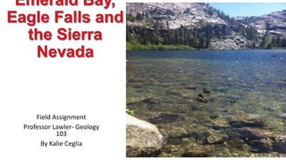
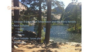
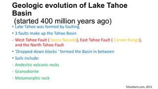
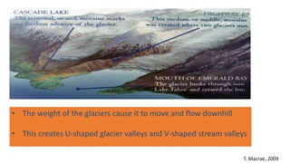
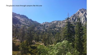
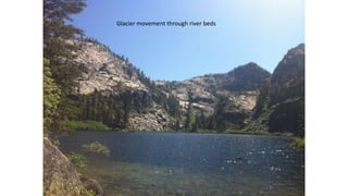
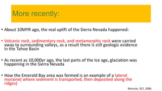
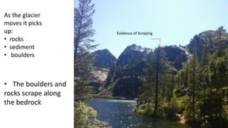
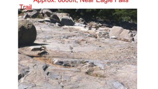
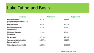
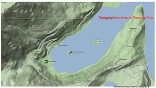
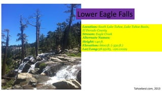
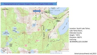
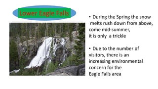
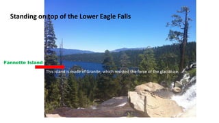
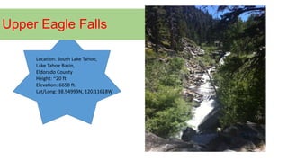
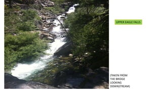
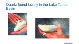
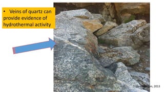
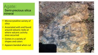
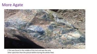
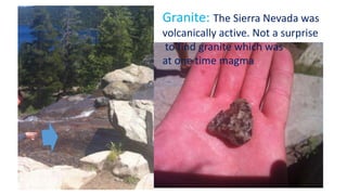
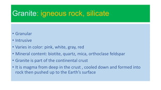
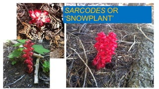
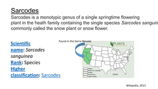
Field Assignment
Professor Lawler- Geology
103
By Kalie Ceglia
• Geologic Evolution of Tahoe Basin and the Sierra Nevada
• Rock Samples
• Quartz
• Agate
• Granite
• Plant Sample- ‘snow plant’
• References
Geologic evolution of Lake Tahoe
Basin
(started 400 million years ago)
• Lake Tahoe was formed by faulting
• 3 faults make up the Tahoe Basin
- West Tahoe Fault ( Sierra Nevada), East Tahoe Fault ( Carson Range),
and the North Tahoe Fault
• ‘Dropped down blocks ‘ formed the Basin in between
• Soils include:
- Andesitic volcanic rocks
- Granodiorite
- Metamorphic rock
Tahoefacts.com, 2013
T. Macrae, 2009
• The weight of the glaciers cause it to move and flow downhill
• This creates U-shaped glacier valleys and V-shaped stream valleys
The glaciers move through canyons like this one
Glacier movement through river beds
More recently:
• About 10MYR ago, the real uplift of the Sierra Nevada happened:
• Volcanic rock, sedimentary rock, and metamorphic rock were carried
away to surrounding valleys, as a result there is still geologic evidence
in the Tahoe Basin
• As recent as 10,000yr ago, the last parts of the Ice age, glaciation was
happening in the Sierra Nevada
• How the Emerald Bay area was formed is an example of a lateral
moraine( where sediment is transported, then deposited along the
ridges)
Monroe, 357, 2006
Evidence of Scraping
As the glacier
moves it picks
up:
• rocks
• sediment
• boulders
• The boulders and
rocks scrape along
the bedrock
Approx. 6800ft, Near Eagle Falls
Trail
Lake Tahoe and Basin
Features Metric unit English unit
Maximum depth
(second deepest in the U.S.)
501 m 1,645 ft
Average depth 305 m 1,000 ft
Maximum diameter
(north-south)
35 km 22 mi
Minimum diameter
(east-west)
19 km 12 mi
Surface area 495 km2 191 mi2
Average surface elevation
(above sea level)
1,897 m 6,225 ft
Highest peak (Freel Peak) 3,320 m 10,891 ft
Tahoe.usgs.gov,2013
Topographical map of Emerald Bay
Americansouthwest.net,2013
The Glaciers Taking Shape
Glaciers:
• Glaciers are very large bodies of snow and ice combined
• When more snow accumulates than can melt, glaciers are formed
• The snow begins to melt in the day but refreezes at night , this forms
the singular sheet of ice
Resendes, 2011
Tahoebest.com, 2013
Lower Eagle Falls
Location: South Lake Tahoe, Lake Tahoe Basin,
El Dorado County
Stream: Eagle Creek
Alternate Names:
Height: 140 ft.
Elevation: 6600 ft. (-350 ft.)
Lat/Long:38.95185, -120.11029
Americansouthwest.net,2013
Topographical of Upper Eagle Falls and Eagle Falls Lake
Location: South Lake Tahoe,
Lake Tahoe Basin,
Eldorado County
Height: ~20 ft.
Elevation: 660 ft.
Lat/Long:
38.94999N,120.11618W
Lower Eagle Falls • During the Spring the snow
melts rush down from above,
come mid-summer,
it is only a trickle
• Due to the number of
visitors, there is an
increasing environmental
concern for the
Eagle Falls area
Standing on top of the Lower Eagle Falls
Fannette Island:
This island is made of Granite, which resisted the force of the glacial ice.
Upper Eagle Falls
Location: South Lake Tahoe,
Lake Tahoe Basin,
Eldorado County
Height: ~20 ft.
Elevation: 6650 ft.
Lat/Long: 38.94999N, 120.11618W
UPPER EAGLE FALLS
(TAKEN FROM
THE BRIDGE
LOOKING
DOWNSTREAM)
Quartz found locally in the Lake Tahoe
Basin
Rockshop,2013
Quartz: mineral
•Form the continental crust
•Most commonly clear, white (milky), or rose in
color
•It is considered a hard and stable mineral
•In metamorphic rock, it can become veineous
and banded in appearance
www.backyardnature.net, 2013
• Veins of quartz can
provide evidence of
hydrothermal activity
Geology.com, 2013
Agate:
Semi-precious silica
mineral
• Microcrystalline variety of
silica
• Associated with and found
around volcanic rocks or
where volcanic activity
once occurred
• Comes in a variety of
shapes and colors
• Appears banded when cut
More Agate
( This was found in the middle of the trail and was the only
other specimen than the picture before during the whole hike)
Granite
Granite: The Sierra Nevada was
volcanically active. Not a surprise
to find granite which was
at one time magma
Granite: igneous rock, silicate
• Granular
• Intrusive
• Varies in color: pink, white, gray, red
• Mineral content: biotite, quartz, mica, orthoclase feldspar
• Granite is part of the continental crust
• It is magma from deep in the crust , cooled down and formed into
rock then pushed up to the Earth’s surface
SARCODES OR
‘SNOWPLANT’
Scientific
name: Sarcodes
sanguinea
Rank: Species
Higher
classification: Sarcodes
Sarcodes
Sarcodes is a monotypic genus of a single springtime flowering
plant in the heath family containing the single species Sarcodes sanguin
commonly called the snow plant or snow flower.
Wikipedia, 2013
Found in the Sierra Nevada
References
Backyard Nature with Jim Conrad. (n.d.). Retrieved from
http://www.backyardnature.net
Eagle Falls Trail Lake Tahoe. (n.d.). Retrieved April 3, 2013, from
http://www.tahoesbest.com/eagle-falls-trail-lake-tahoe
Emerald Bay SP. (n.d.). Retrieved 2013, from
http://www.parks.ca.gov/?page_id=506
Facts about Lake Tahoe. (n.d.). Retrieved from
http://tahoe.usgs.gov/facts.html
Google Image Result for http://www.aboutlaketahoe.com/hiking/topo-
maps/emerald-bay-topo.jpg. (n.d.). Retrieved June 16, 2013, from
http://www.google.com/imgres?imgurl=http://www.aboutlaketahoe.com/
hiking/topo-maps/emerald-bay-
topo.jpg&imgrefurl=http://www.aboutlaketahoe.com/hiking/emerald_bay
Granite: Igneous Rock - Pictures, Definition & More. (n.d.).
Retrieved from http://geology.com/rocks/granite.shtml
Guyton, B. (1998). Glaciers of California: Modern glaciers, ice age
glaciers, origin of Yosemite Valley, and a glacier tour in the Sierra
Nevada. Berkeley: University of California Press.
Hill, M. (1975). Geology of the Sierra Nevada. Berkeley: University
of California Press.
Lake Tahoe Facts, Natural History, & Human Histroy. (n.d.).
Retrieved June from
http://www.tahoeadventuresports.com/misc/tahoefacts.htm
Macrae, T. (n.d.). Born of glaciers | Beetles In The Bush.
Retrieved April 5, 2013, from
http://beetlesinthebush.wordpress.com/2009/03/17/born-of-glaciers/
Monroe, J. S., & Wicander, R. (2006). The changing Earth:
Exploring geology and evolution. Belmont, CA: Thomson
Brooks/Cole.
Resendes (2011). Plate tectonics: Continental drift and mountain
building. Berlin: Springer-Verlag.
Sarcodes - Wikipedia, the free encyclopedia. (n.d.).
Retrieved May 15, 2013, from http://en.wikipedia.org/wiki/Sarcodes
Topographic Map of the Eagle Falls Trail, Lake Tahoe, California.
(n.d.). Retrieved from
http://www.americansouthwest.net/california/lake_tahoe/eagle-falls-
trail-map.html
Wikipedia, the free encyclopedia. (n.d.). Retrieved June 18, 2013,
from http://en.wikipedia.org/

Field assgt.

  • 1.
    Field Assignment Professor Lawler-Geology 103 By Kalie Ceglia
  • 2.
    • Geologic Evolutionof Tahoe Basin and the Sierra Nevada • Rock Samples • Quartz • Agate • Granite • Plant Sample- ‘snow plant’ • References
  • 3.
    Geologic evolution ofLake Tahoe Basin (started 400 million years ago) • Lake Tahoe was formed by faulting • 3 faults make up the Tahoe Basin - West Tahoe Fault ( Sierra Nevada), East Tahoe Fault ( Carson Range), and the North Tahoe Fault • ‘Dropped down blocks ‘ formed the Basin in between • Soils include: - Andesitic volcanic rocks - Granodiorite - Metamorphic rock Tahoefacts.com, 2013
  • 4.
    T. Macrae, 2009 •The weight of the glaciers cause it to move and flow downhill • This creates U-shaped glacier valleys and V-shaped stream valleys
  • 5.
    The glaciers movethrough canyons like this one
  • 6.
  • 7.
    More recently: • About10MYR ago, the real uplift of the Sierra Nevada happened: • Volcanic rock, sedimentary rock, and metamorphic rock were carried away to surrounding valleys, as a result there is still geologic evidence in the Tahoe Basin • As recent as 10,000yr ago, the last parts of the Ice age, glaciation was happening in the Sierra Nevada • How the Emerald Bay area was formed is an example of a lateral moraine( where sediment is transported, then deposited along the ridges) Monroe, 357, 2006
  • 8.
    Evidence of Scraping Asthe glacier moves it picks up: • rocks • sediment • boulders • The boulders and rocks scrape along the bedrock
  • 9.
    Approx. 6800ft, NearEagle Falls Trail
  • 10.
    Lake Tahoe andBasin Features Metric unit English unit Maximum depth (second deepest in the U.S.) 501 m 1,645 ft Average depth 305 m 1,000 ft Maximum diameter (north-south) 35 km 22 mi Minimum diameter (east-west) 19 km 12 mi Surface area 495 km2 191 mi2 Average surface elevation (above sea level) 1,897 m 6,225 ft Highest peak (Freel Peak) 3,320 m 10,891 ft Tahoe.usgs.gov,2013
  • 11.
    Topographical map ofEmerald Bay Americansouthwest.net,2013
  • 12.
    The Glaciers TakingShape Glaciers: • Glaciers are very large bodies of snow and ice combined • When more snow accumulates than can melt, glaciers are formed • The snow begins to melt in the day but refreezes at night , this forms the singular sheet of ice Resendes, 2011
  • 13.
    Tahoebest.com, 2013 Lower EagleFalls Location: South Lake Tahoe, Lake Tahoe Basin, El Dorado County Stream: Eagle Creek Alternate Names: Height: 140 ft. Elevation: 6600 ft. (-350 ft.) Lat/Long:38.95185, -120.11029
  • 14.
    Americansouthwest.net,2013 Topographical of UpperEagle Falls and Eagle Falls Lake Location: South Lake Tahoe, Lake Tahoe Basin, Eldorado County Height: ~20 ft. Elevation: 660 ft. Lat/Long: 38.94999N,120.11618W
  • 15.
    Lower Eagle Falls• During the Spring the snow melts rush down from above, come mid-summer, it is only a trickle • Due to the number of visitors, there is an increasing environmental concern for the Eagle Falls area
  • 16.
    Standing on topof the Lower Eagle Falls Fannette Island: This island is made of Granite, which resisted the force of the glacial ice.
  • 17.
    Upper Eagle Falls Location:South Lake Tahoe, Lake Tahoe Basin, Eldorado County Height: ~20 ft. Elevation: 6650 ft. Lat/Long: 38.94999N, 120.11618W
  • 18.
    UPPER EAGLE FALLS (TAKENFROM THE BRIDGE LOOKING DOWNSTREAM)
  • 19.
    Quartz found locallyin the Lake Tahoe Basin Rockshop,2013
  • 20.
    Quartz: mineral •Form thecontinental crust •Most commonly clear, white (milky), or rose in color •It is considered a hard and stable mineral •In metamorphic rock, it can become veineous and banded in appearance www.backyardnature.net, 2013
  • 21.
    • Veins ofquartz can provide evidence of hydrothermal activity Geology.com, 2013
  • 22.
    Agate: Semi-precious silica mineral • Microcrystallinevariety of silica • Associated with and found around volcanic rocks or where volcanic activity once occurred • Comes in a variety of shapes and colors • Appears banded when cut
  • 23.
    More Agate ( Thiswas found in the middle of the trail and was the only other specimen than the picture before during the whole hike)
  • 24.
    Granite Granite: The SierraNevada was volcanically active. Not a surprise to find granite which was at one time magma
  • 25.
    Granite: igneous rock,silicate • Granular • Intrusive • Varies in color: pink, white, gray, red • Mineral content: biotite, quartz, mica, orthoclase feldspar • Granite is part of the continental crust • It is magma from deep in the crust , cooled down and formed into rock then pushed up to the Earth’s surface
  • 26.
  • 27.
    Scientific name: Sarcodes sanguinea Rank: Species Higher classification:Sarcodes Sarcodes Sarcodes is a monotypic genus of a single springtime flowering plant in the heath family containing the single species Sarcodes sanguin commonly called the snow plant or snow flower. Wikipedia, 2013 Found in the Sierra Nevada
  • 28.
    References Backyard Nature withJim Conrad. (n.d.). Retrieved from http://www.backyardnature.net Eagle Falls Trail Lake Tahoe. (n.d.). Retrieved April 3, 2013, from http://www.tahoesbest.com/eagle-falls-trail-lake-tahoe Emerald Bay SP. (n.d.). Retrieved 2013, from http://www.parks.ca.gov/?page_id=506 Facts about Lake Tahoe. (n.d.). Retrieved from http://tahoe.usgs.gov/facts.html Google Image Result for http://www.aboutlaketahoe.com/hiking/topo- maps/emerald-bay-topo.jpg. (n.d.). Retrieved June 16, 2013, from http://www.google.com/imgres?imgurl=http://www.aboutlaketahoe.com/ hiking/topo-maps/emerald-bay- topo.jpg&imgrefurl=http://www.aboutlaketahoe.com/hiking/emerald_bay
  • 29.
    Granite: Igneous Rock- Pictures, Definition & More. (n.d.). Retrieved from http://geology.com/rocks/granite.shtml Guyton, B. (1998). Glaciers of California: Modern glaciers, ice age glaciers, origin of Yosemite Valley, and a glacier tour in the Sierra Nevada. Berkeley: University of California Press. Hill, M. (1975). Geology of the Sierra Nevada. Berkeley: University of California Press. Lake Tahoe Facts, Natural History, & Human Histroy. (n.d.). Retrieved June from http://www.tahoeadventuresports.com/misc/tahoefacts.htm Macrae, T. (n.d.). Born of glaciers | Beetles In The Bush. Retrieved April 5, 2013, from http://beetlesinthebush.wordpress.com/2009/03/17/born-of-glaciers/
  • 30.
    Monroe, J. S.,& Wicander, R. (2006). The changing Earth: Exploring geology and evolution. Belmont, CA: Thomson Brooks/Cole. Resendes (2011). Plate tectonics: Continental drift and mountain building. Berlin: Springer-Verlag. Sarcodes - Wikipedia, the free encyclopedia. (n.d.). Retrieved May 15, 2013, from http://en.wikipedia.org/wiki/Sarcodes Topographic Map of the Eagle Falls Trail, Lake Tahoe, California. (n.d.). Retrieved from http://www.americansouthwest.net/california/lake_tahoe/eagle-falls- trail-map.html Wikipedia, the free encyclopedia. (n.d.). Retrieved June 18, 2013, from http://en.wikipedia.org/