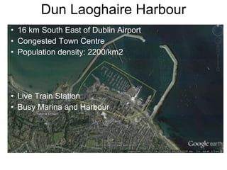
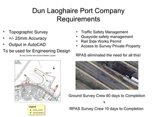
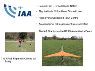
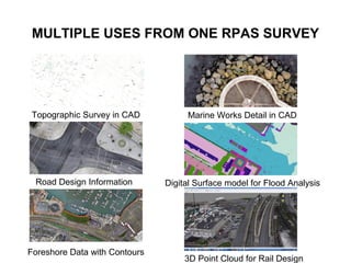
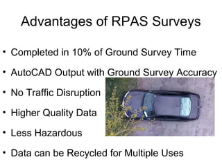
This document summarizes scanning, mobile mapping, and aerial imaging solutions from Gulf Positioning Systems for monitoring and managing quarry and mining operations. It describes static laser scanning using a Trimble TX8 scanner, mobile spatial mapping with a Trimble MX2 system, and aerial imaging with a Trimble UX5 HP drone. Gulf Positioning provides end-to-end solutions including data collection, processing, analytics and management services to increase efficiency and profitability.
This document discusses using big telematics data from vehicle tracking to assess vehicular emissions. It provides details on:
- Sources of telematics data like fleet surveillance and insurance data.
- Benefits like accounting for local driving conditions like traffic flow and weather in emission assessments.
- Methodology used to clean the data, model instantaneous emissions, and scale emission factors based on fleet mix and traffic flows.
- Case studies conducted in Sheffield and Leeds examining variability in driver behavior and emissions by time of day, weather, and other factors.
- Ongoing work to refine estimates and model scenarios like potential clean air zones.
This document discusses the process of creating a tax parcel split in Preston County using GIS software. It involves identifying the parent parcel to be split, verifying surrounding parcel information, using an AutoCAD dataset from previous tax maps, and making adjustments to align the data between different coordinate systems. Challenges include roads with varying widths and parcels surveyed to different scales. The final tax map provides key parcel identification and ownership information.
Emma Gibbons - Model uncertainty in the assessment of major infrastructure pr...IES / IAQM
DMUG remains the key annual event for experts in this field. Unmissable speakers will be examining topical issues in emissions, exposure and dispersion modelling.
Greater Manchester's CAZ - Hazel Peace from JACOBSIES / IAQM
Hear from those who are working directly with the latest policy and get an insight into the likely implications from Defra’s upcoming Air Quality Plan.
Draft National Air Quality Plan - Claire HolmanIES / IAQM
Hear from those who are working directly with the latest policy and get an insight into the likely implications from Defra’s upcoming Air Quality Plan.
A presentation by SMART Infrastructure Facility Research Director Dr Pascal Perez to the International Symposium For Next Generation Infrastructure, Vienna, 30 September - 1 October 2014.
This document outlines the current and proposed logistics models for exporting lumber from British Columbia. Currently, empty containers are delivered by rail and lumber is transported 350km by truck to Vancouver for transloading before shipping. The proposed model would transport lumber 90km by truck to Cache Creek for transloading and rail transport to dock, reducing road congestion and costs while lowering emissions. A cost-benefit analysis over 5 years estimates a 12.7-12.9% reduction in overall costs and 27.2% savings for containers processed at Cache Creek under the new model. The key benefits are more efficient supply chain operations, reduced transportation costs and environmental impact.
Forum presentation #4 innovative signal control at mlk cve5022 c-5110c_finNathan Baker
The document summarizes a presentation on innovative signal control for an intersection in Uptown Cincinnati. It analyzed the existing traffic conditions and performance of the pre-timed signal control, which was found to have long delays. An alternative with actuated signal control and geometric changes was modeled and found to improve traffic flow. An adaptive traffic signal control system was also proposed, which uses algorithms to adjust signal timing in response to real-time traffic conditions. Modeling showed this approach could reduce delays and increase speeds compared to the existing control system. The presentation concluded with recommendations to further optimize the adaptive system and evaluate impacts and costs of implementation.
The document analyzes two proposals to improve transportation in Ghana: a bus rapid transit system in Accra and upgrading ferry service on the Volta River. It finds that a bus rapid transit system could save over 2 million hours of travel time per year, worth over $3 million in economic benefits. For the ferry service, the analysis estimates benefits from reduced transportation costs, emissions, and road maintenance, finding a benefit-cost ratio above 1 for both proposals, indicating both interventions could improve mobility and reduce congestion in Ghana.
The economic growth literature suggests that the volume of infrastructure stock as well as its quality positively and impacts economic growth by, among others, decreasing the cost of production and transportation of goods and services, improving the productivity of input factors, and creating indirect positive externalities.
The document discusses using the International Vehicle Emission (IVE) model to estimate emissions from mobile sources in Delhi. IVE allows estimating emissions of criteria pollutants, toxics, and greenhouse gases from on-road vehicles by accounting for vehicle technology, driving patterns, and local conditions. It requires data on vehicle emissions rates, activity, and fleet distribution collected through field studies. IVE has been successful in developing initial emissions inventories for cities and educating local groups on estimating mobile source emissions. Additional field studies are continuing to refine the model in other locations.
The document provides an update on the status of Galileo in May 2018. It discusses Galileo deployment progress including satellites launched and planned launches. It summarizes the Galileo downstream value chain and efforts to stimulate user adoption. Open service performance is outlined achievement of targets for ranging accuracy, availability, timing and synchronization. Dual frequency capability is highlighted as important for applications requiring higher precision. The document outlines services including navigation message authentication, high accuracy, and search and rescue. It discusses the evolution of Galileo including enhanced message design and new potential services.
This document discusses new features that will enhance the Galileo satellite navigation system, including navigation message authentication (OS-NMA) and a free high accuracy service. OS-NMA will help authenticate navigation data and protect against spoofing attacks. The high accuracy service will provide decimeter-level positioning accuracy without additional ground communications. The document also outlines upcoming tests of these features and an initiative to fund development of user terminals that can take advantage of them.
This document analyzes traffic data collected from two locations: Rassel Square to Panthopath and Panthopath to Rassel Square. The analysis includes:
1. Vehicle composition - Light vehicles make up 49% of traffic, while motorcycles and auto rickshaws each make up 10%.
2. Directional distribution - Traffic flows vary by time of day and direction. More vehicles travel from Panthopath to Rassel Square compared to the opposite direction.
3. Average daily traffic (ADT) and annual average daily traffic (AADT) - ADT and AADT are calculated for each location to understand typical and annual traffic volumes.
The document provides an overview of the Greater Brisbane Transport Demand Model (BNE Model). It summarizes the model's key components, including demand segments, demography, networks, volume delay functions, parking and toll models, and public transport modeling. It also describes the model's calibration process and convergence criteria. The model uses a discrete choice approach and is the first of its kind for an Australian transport demand model.
The Joint Research Centre (JRC) is the European Commission's in-house science service providing scientific and technical support for EU policies. It has 7 institutes across 5 EU member states with around 2800 staff. The JRC operates a state-of-the-art GNSS laboratory capable of generating complex interference scenarios to test GNSS receivers. It currently supports several EU projects related to Galileo and looks forward to supporting upcoming calls under the European GNSS programmes.
Automatic vehicle location (AVL) systems use GPS and other technologies to track vehicles in real-time. AVL determines a vehicle's exact position and relays it to a control center along with other data like status, heading and speed. There are two main types of AVL systems - passive tracking which stores location data for later use, and real-time tracking which combines GPS and cellular networks to transmit position continuously. AVL has many applications including fleet management, emergency services, and cargo/asset tracking.
GSA - Aviation Market Development Officer, Carmen Aguilera presents "GSA EGNOS and Galileo for Aviation" during the Eurocontrol briefing session, @ World ATM Congress, Madrid, 09/03/2016
"A big data approach for investigating the performance of road infrastructure...TRUSS ITN
“Using truck sensors for road pavement performance investigation” is a research project within TRUSS, an innovative training network funded from the EU under the Horizon 2020 programme. The project aims at assessing the impact of the condition of the road pavement unevenness and macrotexture, on the fuel consumption of trucks to reduce uncertainty in the framework of life-cycle assessment of road pavements. In the past, several studies claimed that a road pavement in poor condition can affect the fuel consumption of road vehicles. However, these conclusions are based just on tests performed on a selection of road segments using a few vehicles and this may not be representative of real conditions. That leaves uncertainty in the topic and it does not allow road mangers to review the current road maintenance strategies that could otherwise help in reducing costs and greenhouse gas emissions from the road transport industry. The project investigated an alternative approach that considers large quantities of data from standard sensors installed on trucks combined with information in the database of road agencies that includes measurements of the conditions of the road network. In particular, using advanced regression techniques, a fuel consumption model that can take into consideration these effects has been developed. The paper presents a summary of the findings of the project, it highlights implications for road asset management and the road maintenance strategies and discusses advantages and limitations of the approach used, pointing out possible improvements and future work.
Abstract: Considering data from 260 articulated trucks, with ∼12900 cc Euro 6 engines driving along a motorway in England (M18), the study first shows how different approaches lead to the conclusion that road pavement surface conditions influence fuel consumption of the considered truck fleet. Then, a multiple linear regression for the prediction of fuel consumption was generated. The model shows that evenness and macrotexture can impact the truck fuel consumption by up to 3% and 5%, respectively. It is a significant impact which confirms that, although the available funding for pavement maintenance is limited, the importance of limiting GHG emissions, together with the economic benefits of reducing fuel consumption are reasons to improve road condition.
TGS GPS- Eastern Canada Interpretation- Newfoundland and Flemish PassTGS
TGS has generated a sequence stratigraphic interpretation and play fairway analysis of the Northeast Newfoundland Shelf utilizing new seismic survey data and well data. The analysis provides a geological model of basin development over time, identifies reservoir and seal distributions, and assesses hydrocarbon prospects. Key deliverables include mapped sequences, depositional environments, seismic facies, structures, and a summary of plays and fairways to help reduce exploration risk. Final products are scheduled for delivery in early 2015.
This document provides an overview and summary of updates to Highways England guidance on air quality assessments, best practices for DMRB air quality assessments, and a new DMRB air quality model tool. Key points include: Highways England guidance has been updated to be more risk-based and emphasize early collaboration, monitoring, and mitigation; best practices for assessments include ensuring appropriate traffic and monitoring data and temporal emissions profiles in modeling; and the new DMRB tool allows for more detailed traffic and meteorological inputs and a GIS interface for roads and receptors.
Remote Tower Press Briefing Farnborough 2014Saab AB
Presentation from Per Ahl, Vice President, Head of Commercial, Civil Security and Traffic Management, Market Area Europe & Greater Middle East at Farnborough 2014.
Read more about Saab's Remote Tower solutions here: http://www.saabgroup.com/Civil-security/Air-Transportation-and-Airport-Security/Air-Traffic-Management-Solutions/Remote-Tower-Pre/
Austria's traffic model is used by national and state authorities to plan infrastructure projects. It forecasts road and rail traffic volumes based on demographic and economic data. The iMOVE project aims to improve the model by combining different cargo movement surveys, incorporating toll data, and calibrating origin-destination flows using traffic counts. This will produce a more accurate and repeatable process for compiling cargo movement data on Austria's road network.
We compared the accuracy of geospatial data derived from a RPAS and an RTK GPS
Aim: To understand the mapping applications RPAS can deployed for
Objective: By the end of this presentation the audience will be able to list the horizontal and vertical accuracies achieved by a RPAS
Check http://www.rpas.ie
At Esri UK Annual Conference 2014
In the UK there are hundreds of wind farm applications made every year. This data is recorded and provided free of charge by Renewables UK and DECC. There are thousands of applications listed in these databases. Some of the proposed turbines in these applications will interfere with radar due to their height and location, many will not. In order to assess where to focus our efforts we need to identify where these are, on what scale the developments, which radars they are likely to interfere with and at what stage of planning they are at.
When these developments have been identified, we need to establish the best location to position our 3D radar so we can successfully mitigate the effects of wind turbines on surrounding radars.
Esri ArcGIS assists all departments from Sales through to Engineering and really enables us to manage our data in a way that everyone understands.
At the 2014 annual Dispersion Modellers user group meeting guest speaker Scott Hamilton spoke on the topic: Modelling the impact of road traffic emissions in Riyadh using open source models and rapid geoprocessing
Transnet who we are- by Transnet Port Terminals Chief Executive, Karl SocikwaTransnet Port Terminals
Transnet is a South African state-owned company that operates ports, rail, pipelines, and other infrastructure. It has over 50,000 employees. Transnet plans to invest R300 billion over 7 years to expand rail, port, and pipeline capacity to meet growing demand. This includes R77 billion for ports. The Port of Durban is undergoing projects to increase container capacity from 700,000 TEUs to 1.3 million TEUs by 2016 and expand other terminals. A new port is also planned to be dug out of the old Durban International Airport site.
NDGeospatialSummit2019 - Drone Based Lidar and the Future of Survey/GISNorth Dakota GIS Hub
This document discusses drone-based LiDAR technology and its benefits over traditional survey methods. HEI has 12 certified drone pilots and uses drones equipped with high-quality sensors to capture LiDAR point clouds for transportation, environmental, and land surveying projects. Drone-based LiDAR allows large areas to be surveyed quickly, safely, and accurately, with point densities over 30 points per square foot. HEI and its partner SkySkopes process the raw LiDAR data to create deliverables like topographic maps, digital terrain models, and 3D models for engineering design in a fraction of the time of traditional ground-based surveying.
Sub-Surface Detection Ltd's newsletter summarizes their projects and activities in 2016. It discusses completing utility markouts for CPB on the State Highway 16 upgrade, conducting a GPR and GPS survey to map utilities for Bartley Consultants on East Coast Road, using UAV technology to survey utilities at Sylvia Park shopping centre for Dominion Contractors, providing training and qualifications for technicians, and expanding their team by adding new staff members Vish, Damon, and Matt.
Development and validation of a rapid urban scale dispersion modelling platform Scott Hamilton
Here we describe the development and of a new dispersion model (RapidAir®, Ricardo-AEA Ltd) designed as a decision support platform, and describe a recent validation exercise
in London, UK which was carried out by Strathclyde University, UK. Ricardo’s RapidAir model comprises several libraries written in the python programming language with functionality
specific to air quality analysis (e.g. handling time series observation data, array based processing of road emissions).
Development and validation of a rapid urban scale dispersion modelling platformScott Hamilton
Presented at the 16th Annual CMAS Conference, Chapel Hill, NC, October 23-25, 2017.
Authors:
Scott L. Hamilton*. Ricardo Energy and Environment, UK
Nicola Masey, Iain Beverland. University of Strathclyde, UK
The document provides an overview of a company called e-Marine Co. Ltd. that develops e-navigation and smart ship solutions. It summarizes the company's history and growth from 2001 founding as DIMARS Co. to developing innovative solutions like ISIG and optimal navigation systems. The current focus is on smart ship technology including maritime IoT, big data, and preparing for autonomous ships. Key customers and partnerships are also mentioned like Hyundai Heavy Industries.
The company presentation summarizes e-Marine's history and focus on smart ship and maritime IoT solutions. It provides an overview of key partnerships and certifications since 2001, current solutions including ISIG and remote monitoring systems, and future goals around autonomous ships leveraging IoT, big data, and artificial intelligence. The presentation also highlights projections for growing domestic and international markets in smart ships and autonomous vessels starting in 2020.
Dear Sir ,,,Greetings!
Please find enclosed my resume for '' Sr .Surveyor ". I've more than 15 years experience an exposure in Water Reservoirs Roads Bridge,Towers, Building Groups, Crude Oil Pipeline projects, Infrastructure Civil Oil and Gas Industries.
I've made numerous contribution to my previous and present employer that have gained me professional experience at different Projects i.e. high rise Towers Crude Oil Pipeline Projects, G L Noble Denton(Third Party Inspection) and presently working with Dubai Engineering Consulting Company Jeddah Saudi Arabia.
These accomplishments are derived from my exceptional communication and interpersonal skills, unparalleled work ethic and strong attention to details. I am enthusiastic about exploring opportunities with your organization and looking forward to hear from your side.
Best Regards ,
Muhammad Amjad
Sr.Survey Inspector / Civil Engineer
Dubai Engineering Consultants Jeddah Saudi Arabia
Briman Strategic Water Reservoir Project
World’s Largest Drinking Water Storage Facility.
Contact NO = KSA ,00966580667473 // PAK , 00923007565840
The document discusses potential uses of unmanned aerial systems (UAS) for remote sensing and mapping applications. It provides an overview of The Sanborn Map Company, which specializes in aerial data collection and processing. The company sees opportunities to integrate UAS technology into its existing service offerings to expand into new markets and services. Example applications discussed include agriculture, ranching, emergency response, and infrastructure inspection. Regulatory issues and business models for UAS services are also covered.
THE THAR DRY PORT IS GROUP COMPANY OF HPCSL SINCE LAST ONE DECADE IN
A) PRIVATE ICD OPERATION AT JODHPUR (RAJASTHAN) AND SANAND (GUJARAT)
B) PRIVATE RAIL OPERATION FROM GATEWAY PORT TO BOTH ICDS
C) IN HOUSE FLEET OF MORE THAN 200 TRAILORS FOR FIRST AND LAST MILE.
D) WARE HOUSING SPACE FOR MORE THAN 4 LAC SQ FT - BONDED AND NON BONDED
C) PROJECT CARGO IMPORT FROM PORT TO SITE IN RAJASTHAN IN SOLAR WITH 3PL LOGISTICS
D) DOMESTIC CARGO MOVEMENT FROM ICD TO PORT.
eMarine Global Inc. is a Korean company that provides e-navigation and smart ship solutions. It has experienced double-digit revenue growth for the past two years and has secured large contracts in 2020 that are expected to more than double its revenue to $14 million. The company has technology ready for autonomous ships and seeks to penetrate the vessel traffic system market. It has strong relationships with Korean governments and large shipbuilding companies.
• Diploma Architectural Assistantship with 10+ years of professional experience and good academic records.
• Presently working as a Sr. Survey Engineer for CGC Converse Technologies.
• Having 9+ years of surveying experience in Gulf.
• Working as Draftsman for nearly 1 year.
• Proactive and hardworking person handled tight deadlines and heavy pressure
UK Content – Opportunities in Offshore O&M, Alun Roberts, BVG Associates Invest Northern Ireland
Presentation from the Supply Chain Opportunities in the Onshore and Offshore Wind Operation and Maintenance Sectors held at Down Royal Racecourse, Lisburn 27th November 2013
This document discusses the laser scanning and mobile mapping services provided by Severn Partnership. It outlines the various laser scanning and mobile mapping equipment used including terrestrial laser scanners, trolley systems, and mobile mapping vehicles. It also provides examples of rail, subsurface utility, and highway projects where these techniques have been applied and discusses the deliverables including point clouds, 3D models, and detailed analyses and reports.
UAS Applications for Civil EngineeringUAS Colorado
Presentation provided by Mary Wohnrade, Brendan Thompson and Don Schoen of Wohnrade Civil Engineers at the October 26, 2016 Rocky Mountain UAS Professionals Meetup group.
As the aviation community continues to implement Next Generation Air Transportation System (NextGen) initiatives, operators want to know what the initiatives are and how they affect individual operators. The question always comes down to value: If I upgrade my aircraft, what will I get for the often substantial investment?
Datalink services are available in most of the world’s oceanic routes and in some domestic airspace, as well. The services provide invaluable support at transfer points where aircraft enter or exit domestic airspace and enter oceanic. The enhanced communication abilities aid the ATC on both sides of tracks and particularly when a controller at one center hands off an aircraft to another ATC center because with a FANS-equipped aircraft, the handoff occurs seamlessly behind the scenes.
Along the routes that have not yet been mandated for FANS, the flight crew has to call an ATC and give verbal updates as to their whereabouts with no support from ground surveillance. This lack of accurate position data is a problem because if an ATC doesn’t know exactly where an aircraft is, the ATC has to maintain greater distance between aircraft. With FANS, an ATC can track aircraft along the entire route and safely and efficiently track and accommodate more aircraft in the airspace. The majority of these enhanced services are available to FANS 1/A-equipped aircraft. Ground facilities around the world are upgrading to FANS work stations.
Which datalink service a particular operator selects depends entirely on what equipment is available for the type of aircraft.
FLY SAFE!!!!
Clean Air Zones- big models for big questionsScott Hamilton
Presented at the Scottish Government Air Quality Conference, January 2018.
The presentation shows the results of applying our RapidAir air quality model to calculating high resolution concentrations of NO2 and PM10 for an area containing all of Scotland's cities and most of its major towns.
Similar to RPAS Topographic Survey at Dun Laoghaire Town Centre and Harbour - European commission (20)
Industrial Tech SW: Category Renewal and CreationChristian Dahlen
Every industrial revolution has created a new set of categories and a new set of players.
Multiple new technologies have emerged, but Samsara and C3.ai are only two companies which have gone public so far.
Manufacturing startups constitute the largest pipeline share of unicorns and IPO candidates in the SF Bay Area, and software startups dominate in Germany.
SATTA MATKA SATTA FAST RESULT KALYAN TOP MATKA RESULT KALYAN SATTA MATKA FAST RESULT MILAN RATAN RAJDHANI MAIN BAZAR MATKA FAST TIPS RESULT MATKA CHART JODI CHART PANEL CHART FREE FIX GAME SATTAMATKA ! MATKA MOBI SATTA 143 spboss.in TOP NO1 RESULT FULL RATE MATKA ONLINE GAME PLAY BY APP SPBOSS
Building Your Employer Brand with Social MediaLuanWise
Presented at The Global HR Summit, 6th June 2024
In this keynote, Luan Wise will provide invaluable insights to elevate your employer brand on social media platforms including LinkedIn, Facebook, Instagram, X (formerly Twitter) and TikTok. You'll learn how compelling content can authentically showcase your company culture, values, and employee experiences to support your talent acquisition and retention objectives. Additionally, you'll understand the power of employee advocacy to amplify reach and engagement – helping to position your organization as an employer of choice in today's competitive talent landscape.
Part 2 Deep Dive: Navigating the 2024 Slowdownjeffkluth1
Introduction
The global retail industry has weathered numerous storms, with the financial crisis of 2008 serving as a poignant reminder of the sector's resilience and adaptability. However, as we navigate the complex landscape of 2024, retailers face a unique set of challenges that demand innovative strategies and a fundamental shift in mindset. This white paper contrasts the impact of the 2008 recession on the retail sector with the current headwinds retailers are grappling with, while offering a comprehensive roadmap for success in this new paradigm.
The 10 Most Influential Leaders Guiding Corporate Evolution, 2024.pdfthesiliconleaders
In the recent edition, The 10 Most Influential Leaders Guiding Corporate Evolution, 2024, The Silicon Leaders magazine gladly features Dejan Štancer, President of the Global Chamber of Business Leaders (GCBL), along with other leaders.
3 Simple Steps To Buy Verified Payoneer Account In 2024SEOSMMEARTH
Buy Verified Payoneer Account: Quick and Secure Way to Receive Payments
Buy Verified Payoneer Account With 100% secure documents, [ USA, UK, CA ]. Are you looking for a reliable and safe way to receive payments online? Then you need buy verified Payoneer account ! Payoneer is a global payment platform that allows businesses and individuals to send and receive money in over 200 countries.
If You Want To More Information just Contact Now:
Skype: SEOSMMEARTH
Telegram: @seosmmearth
Gmail: seosmmearth@gmail.com
Best Competitive Marble Pricing in Dubai - ☎ 9928909666Stone Art Hub
Stone Art Hub offers the best competitive Marble Pricing in Dubai, ensuring affordability without compromising quality. With a wide range of exquisite marble options to choose from, you can enhance your spaces with elegance and sophistication. For inquiries or orders, contact us at ☎ 9928909666. Experience luxury at unbeatable prices.
Unveiling the Dynamic Personalities, Key Dates, and Horoscope Insights: Gemin...my Pandit
Explore the fascinating world of the Gemini Zodiac Sign. Discover the unique personality traits, key dates, and horoscope insights of Gemini individuals. Learn how their sociable, communicative nature and boundless curiosity make them the dynamic explorers of the zodiac. Dive into the duality of the Gemini sign and understand their intellectual and adventurous spirit.
Understanding User Needs and Satisfying ThemAggregage
https://www.productmanagementtoday.com/frs/26903918/understanding-user-needs-and-satisfying-them
We know we want to create products which our customers find to be valuable. Whether we label it as customer-centric or product-led depends on how long we've been doing product management. There are three challenges we face when doing this. The obvious challenge is figuring out what our users need; the non-obvious challenges are in creating a shared understanding of those needs and in sensing if what we're doing is meeting those needs.
In this webinar, we won't focus on the research methods for discovering user-needs. We will focus on synthesis of the needs we discover, communication and alignment tools, and how we operationalize addressing those needs.
Industry expert Scott Sehlhorst will:
• Introduce a taxonomy for user goals with real world examples
• Present the Onion Diagram, a tool for contextualizing task-level goals
• Illustrate how customer journey maps capture activity-level and task-level goals
• Demonstrate the best approach to selection and prioritization of user-goals to address
• Highlight the crucial benchmarks, observable changes, in ensuring fulfillment of customer needs
IMPACT Silver is a pure silver zinc producer with over $260 million in revenue since 2008 and a large 100% owned 210km Mexico land package - 2024 catalysts includes new 14% grade zinc Plomosas mine and 20,000m of fully funded exploration drilling.
Digital Marketing with a Focus on Sustainabilitysssourabhsharma
Digital Marketing best practices including influencer marketing, content creators, and omnichannel marketing for Sustainable Brands at the Sustainable Cosmetics Summit 2024 in New York
How MJ Global Leads the Packaging Industry.pdfMJ Global
MJ Global's success in staying ahead of the curve in the packaging industry is a testament to its dedication to innovation, sustainability, and customer-centricity. By embracing technological advancements, leading in eco-friendly solutions, collaborating with industry leaders, and adapting to evolving consumer preferences, MJ Global continues to set new standards in the packaging sector.
Navigating the world of forex trading can be challenging, especially for beginners. To help you make an informed decision, we have comprehensively compared the best forex brokers in India for 2024. This article, reviewed by Top Forex Brokers Review, will cover featured award winners, the best forex brokers, featured offers, the best copy trading platforms, the best forex brokers for beginners, the best MetaTrader brokers, and recently updated reviews. We will focus on FP Markets, Black Bull, EightCap, IC Markets, and Octa.
[To download this presentation, visit:
https://www.oeconsulting.com.sg/training-presentations]
This presentation is a curated compilation of PowerPoint diagrams and templates designed to illustrate 20 different digital transformation frameworks and models. These frameworks are based on recent industry trends and best practices, ensuring that the content remains relevant and up-to-date.
Key highlights include Microsoft's Digital Transformation Framework, which focuses on driving innovation and efficiency, and McKinsey's Ten Guiding Principles, which provide strategic insights for successful digital transformation. Additionally, Forrester's framework emphasizes enhancing customer experiences and modernizing IT infrastructure, while IDC's MaturityScape helps assess and develop organizational digital maturity. MIT's framework explores cutting-edge strategies for achieving digital success.
These materials are perfect for enhancing your business or classroom presentations, offering visual aids to supplement your insights. Please note that while comprehensive, these slides are intended as supplementary resources and may not be complete for standalone instructional purposes.
Frameworks/Models included:
Microsoft’s Digital Transformation Framework
McKinsey’s Ten Guiding Principles of Digital Transformation
Forrester’s Digital Transformation Framework
IDC’s Digital Transformation MaturityScape
MIT’s Digital Transformation Framework
Gartner’s Digital Transformation Framework
Accenture’s Digital Strategy & Enterprise Frameworks
Deloitte’s Digital Industrial Transformation Framework
Capgemini’s Digital Transformation Framework
PwC’s Digital Transformation Framework
Cisco’s Digital Transformation Framework
Cognizant’s Digital Transformation Framework
DXC Technology’s Digital Transformation Framework
The BCG Strategy Palette
McKinsey’s Digital Transformation Framework
Digital Transformation Compass
Four Levels of Digital Maturity
Design Thinking Framework
Business Model Canvas
Customer Journey Map
The APCO Geopolitical Radar - Q3 2024 The Global Operating Environment for Bu...APCO
The Radar reflects input from APCO’s teams located around the world. It distils a host of interconnected events and trends into insights to inform operational and strategic decisions. Issues covered in this edition include:
The APCO Geopolitical Radar - Q3 2024 The Global Operating Environment for Bu...
RPAS Topographic Survey at Dun Laoghaire Town Centre and Harbour - European commission
1. RPAS Topographic Survey at Dun
Laoghaire Town Centre and Harbour
- A Case study
P. Barry, R. Coakley of Baseline Surveys Ltd
2. Dun Laoghaire Harbour
• 16 km South East of Dublin Airport
• Congested Town Centre
• Population density: 2200/km2
• Live Train Station
• Busy Marina and Harbour
3. Dun Laoghaire Port Company
Requirements
• Topographic Survey
• +/- 25mm Accuracy
• Output in AutoCAD
To be used for Engineering Design
RPAS eliminated the need for all this!
• Traffic Safety Management
• Quayside safety management
• Rail Side Works Permit
• Access to Survey Private Property
Ground Survey Crew 80 days to Completion
RPAS Survey Crew 10 days to Completion
v
4. Baseline History
• Engineering
Surveyor on tunnels,
roads and bridges.
• 2,500 Topographic
Surveys.
• Over 20 years of
experience.
• Legal Mapping Export.
The RPAS Flight was Carried out
Safely
• adapter of Survey
• Remote Pilot – RPA distance 1200m
• Flight over a Congested Town Centre
• An operational risk assessment was submitted
• The IAA Granted us the RPAS Aerial Works Permit
• Flight Altitude 120m Above Ground Level
5. MULTIPLE USES FROM ONE RPAS SURVEY
Digital Surface model for Flood Analysis
3D Point Cloud for Rail Design
Marine Works Detail in CAD
Road Design Information
Topographic Survey in CAD
Foreshore Data with Contours
6. Advantages of RPAS Surveys
• Completed in 10% of Ground Survey Time
• AutoCAD Output with Ground Survey Accuracy
• No Traffic Disruption
• Higher Quality Data
• Less Hazardous
• Data can be Recycled for Multiple Uses
7. 3rd
Party INSURANCE is Mandatory
In 2013 Baseline Surveys (20 flights) paid
€5,500 in premiums for 2 RPAS (4kg Fixed Wing + 2.8kg VTOL).
This is for a Single RPAS Operating Crew. (Ireland only)
In 2014 Baseline Surveys Paid €3,250 for 30 flights.
8. Conclusion
• European Government Agencies can now look forward to spending less
money on better Geographic Information, so they in turn can make better
informed decisions with less risk to life and less disruption to traffic by
using RPAS to carry out Topographic Surveys. This geographic data can
be recycled for multiple geographical analysis and design uses across a
range of government departments
• On behalf of Baseline Surveys Ltd I would like to thank the staff at the
Irish Aviation Authority for their very helpful and progressive attitude
9. Baseline Surveys Ltd
Mount Desert Lodge,
Lee Road,
Cork, Ireland.
Tel: +353862535285
paudie@baselinesurveys.ie
10. Baseline Surveys Ltd
Mount Desert Lodge,
Lee Road,
Cork, Ireland.
Tel: +353862535285
paudie@baselinesurveys.ie