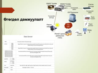
Өгөгдөл дамжуулалт
Ши
лэн
каб
ел
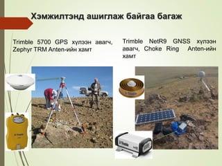
GNSS Trimble
NETR9 хүлээн
авагч Сүлжээний
кабел
Сэлгэх
залгуур
Radio
modem
Reley
II
Релей I дахин
дамжуулах
станц
ООГХүрээлэн
Нарны
хавтан
Тэжээлийн
залгуур
GNSS Trimble
Choke Ring
антен
Сүлжээний
кабел
Радио
долгион
Радио
долгион
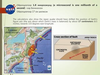
Ойролцоогоор 1.8микросөкунд (a microsecond is one millionth of a
second) –ээр богиноссон
Ойролцоогоор 17 см шилжсэн
The calculations also show the Japan quake should have shifted the position of Earth's
figure axis (the axis about which Earth's mass is balanced) by about 17 centimeters (6.5
inches), towards 133 degrees east longitude.
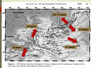
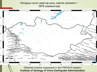
Хятадын нутаг дэвсгэрдэхь хэвтээ шилжилт –
GPS хэмжилтээр
Obtained solution expressed in the ITRF2014 system-
Institute of Geology of China Earthquake Administration
21.
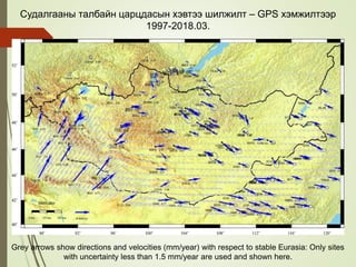
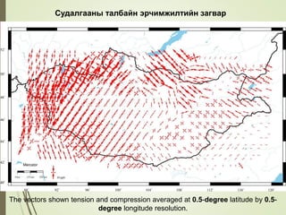
Судалгааны талбайн царцдасынхэвтээ шилжилт – GPS хэмжилтээр
1997-2018.03.
Grey arrows show directions and velocities (mm/year) with respect to stable Eurasia: Only sites
with uncertainty less than 1.5 mm/year are used and shown here.
22.
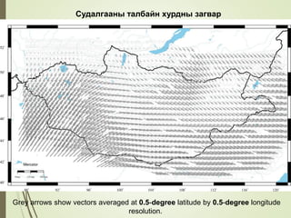
Grey arrows showvectors averaged at 0.5-degree latitude by 0.5-degree longitude
resolution.
Судалгааны талбайн хурдны загвар
23.
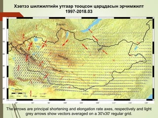
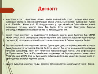
Хэвтээ шилжилтийн утгаартооцсон царцдасын эрчимжилт
1997-2018.03
The arrows are principal shortening and elongation rate axes, respectively and light
grey arrows show vectors averaged on a 30'x30' regular grid.
24.
Судалгааны талбайн эрчимжилтийнзагвар
The vectors shown tension and compression averaged at 0.5-degree latitude by 0.5-
degree longitude resolution.
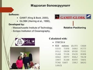
#14 We analyzed all the available GPS datasets in the time span of 1994 to 2018 by using the Gamit/Globk software and constructed time series of GNSS stations referenced to a reference frame ITRF2014 that can give fundamental information for both regional and local geodynamic studies and finally produced the tectonic velocity field providing an updated detailed map of the kinematics of study area.
In my case, the preliminary analysis of gps data carried out at ENS in Paris under the training of Eric Calais who is the Head of Geoscience department of ENS.
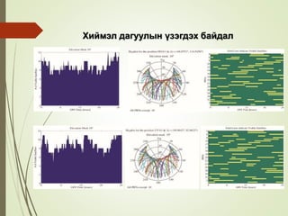
#17 I chose stations from places that are in most eastern and western part of Mongolia in order to achieve better satellite visibility. It is clear on this figure that more satellites visible on western part.
Solid lines indicate the visible satellites by their Pseudo random noise (PRN) codes.