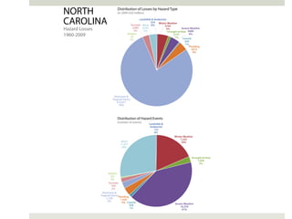
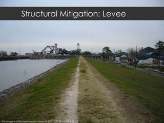
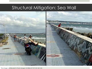
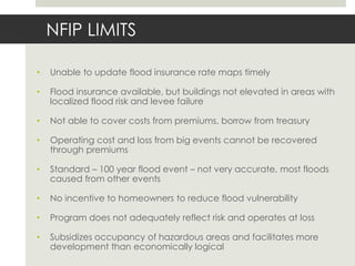
This document discusses hazard mitigation planning challenges in coastal North Carolina. It notes that while the 20 coastal counties have certified hazard mitigation plans, implementing the policy recommendations in the plans remains uneven. Structural mitigation like levees can encourage development in risky areas and have limits. The National Flood Insurance Program also has limitations, as it does not adequately reflect risk and operates at a loss. In conclusion, simply having a hazard mitigation plan does not ensure implementation. Efforts are needed to help counties balance safety and costs, address fragmented implementation among agencies, and provide targeted assistance to rural counties.
NJ Future Sandy One Year Later Planning Sturm Oct 29 2013New Jersey Future
Important post-Sandy planning initiatives, including the state and county hazard mitigation plans and New Jersey Future's local recovery network. Part of the Sandy One Year Later conference Oct. 29, 2013, at Monmouth University, co-presented by the Union of Concerned Scientists and the Recovery Fund as well as New Jersey Future and Monmouth University.
ADB’s Adaptation Program: Poverty Implications and Emerging ResponsesPoverty Environment Net
This document summarizes ADB's efforts to address the poverty implications of climate change through adaptation programs. It finds that vulnerable groups like the poor, women, children and ethnic minorities will be most severely impacted. Case studies from Vietnam show climate change could increase poverty levels significantly in the Mekong Delta. ADB is working to incorporate vulnerability assessments and adaptation options into projects and strategies to make them more climate-resilient and reduce poverty impacts over the long run. Priority areas of focus include climate-proofing infrastructure, analyzing vulnerable sectors and locations, and building staff and local capacity on adaptation and financing approaches.
Here I've shown statistics of some major disasters in Bangladesh. Also discussed how those disasters were managed. And last show some possible steps which can reduce the impact of the disaster.
Boston Harbor, Julie Wormser, Executive Director, The Boston Harbor Association, Co-Author, Preparing for the Rising Tide; National Institute for Coastal & Harbor Infrastructure, John F. Kennedy Center, Boston, Nov. 12, 2013: "The Triple Threat of Rising Sea Levels, Extreme Storms and Aging Infrastructure: Coastal Community Responses and The Federal Role"
The document discusses three main challenges facing Tampa Bay municipalities in increasing their resiliency to sea level rise: educational challenges, definition challenges, and infrastructure challenges. It provides examples of each challenge and recommends actions that can be taken locally to address the challenges, such as preventing new construction in coastal areas, increasing building code standards, and developing long-term plans for protection measures. The document also discusses the Coastal Zoning Management Program and the National Flood Insurance Program as potential tools to help address the challenges.
This document summarizes a regional flagship report on climate change in Arab countries. It notes that climate change is a major development challenge that threatens poverty reduction and economic growth in the region. The report aims to provide information on climate impacts and practical guidance for policymakers on adaptation. It addresses the Arab region as a whole and seeks input from regional researchers and governments. Key findings include increasing temperatures and droughts, threats to water resources, food security and vulnerable populations like rural farmers and coastal communities. The report calls for diversified economic activities, integrated adaptation, and inclusive decision-making to build climate resilience.
Natural Hazard is a common phenomena of Bangladesh which makes visit here every year. It contains a detail study about the natural hazards of Bangladesh with its seasonal distribution, causes, effects and necessary maps. An extended Hazard Calendar has been added here.
Major natural disasters that have affected Bangladesh between 1974 and 2009 include floods, cyclones, tornadoes, droughts, and earthquakes. The most devastating floods occurred in 1988, 1998, and 2004, killing over 3,000 people and causing billions of dollars in economic losses. Cyclones in 1991 and 2007 also killed over 150,000 people and caused billions in damages. Tornadoes have locally destroyed homes and infrastructure. Famine in 1974 resulted in 1.5 million deaths. These frequent natural disasters have significantly impacted lives, the economy, and environment in Bangladesh.
A magnitude 7.6 earthquake struck Kashmir region shared by India and Pakistan on October 8, 2005, causing widespread damage and death. [1] The local, national, and international responses were overwhelmed by the scale of the disaster, as most buildings in the affected areas were not engineered to withstand seismic activity. [2] Over a decade later, many remain displaced and reconstruction efforts have been hampered by the difficult terrain. [3] Underdeveloped areas are more vulnerable to natural disasters due to lack of disaster preparedness and building standards.
North Kingstown, Rhode Island—Municipal Assessment and Adaptation Strategies. Showcase a model for Rhode Island municipalities for assessing climate change and strategies for long-term planning presented by Teresa Crean, URI Coastal Resources Center/Rhode Island Sea Grant
COP21 Event: Adaptation in national development and climate change planningNAP Global Network
This document discusses OECD's work on mainstreaming climate change adaptation into development planning. It finds that while climate change and adaptation are usually mentioned in national development plans, the degree of integration across non-environment sectors varies. Adaptation is most commonly linked to agriculture, forests, and watershed management. Climate plans also frequently connect adaptation to livelihoods like farming, fishing, and forestry. Urban adaptation focuses on building codes and design. The document provides data on international adaptation financing from 2010-2014 and its distribution by country and region.
Presentation delivered by Professor David Hulme at IUB University and ICCCAD in Dhaka, Bangladesh.
Bangladesh Confronts Climate Change is avaiable here: www.anthempress.com/bangladesh-confronts-climate-change-pb
Dr. R. Christopher Goodwin heads a heritage and historical resources preservation firm and has been involved in resiliency planning for Connecticut after Hurricane Sandy. His firm is leading planning efforts in all 29 of Connecticut's coastal communities following the hurricane. When Hurricane Sandy hit New England in 2012, it caused widespread damage and highlighted problems with disaster preparedness along Connecticut's coast. In response, the federal government provided funding through the Sandy Recovery Improvement Act of 2013, while local resiliency planning initiatives began with surveys to inventory historic properties endangered by flooding and sea level rise along the coastline.
This document discusses infrastructure development relating to disaster management in Asia and the Pacific region. It finds that the region experiences some of the worst natural disasters in the world, accounting for 91% of deaths and 49% of economic damage over the past century. While annual deaths from disasters have decreased to 41,000 in recent decades, annual economic damage has nearly tripled to $29 billion. The document analyzes trends in several countries and finds that damage costs have generally increased over time. Regional cooperation is needed to help mitigate disaster impacts and ensure continued economic growth.
'Disaster contingent financing and policy-based lending: Cook Islands'UNDP Climate
This document summarizes a presentation about disaster risk financing and policy-based lending in the Cook Islands. The Cook Islands faces high risks from natural disasters like cyclones due to its geography across multiple small islands. It has taken out an ADB loan to improve disaster resilience through policy reforms. The $13.95 million loan over 3 years supports strengthening disaster management institutions and plans, increasing the resilience of infrastructure, and expanding disaster risk financing instruments. It will be implemented through agreed policy actions and reforms focused on improving preparedness, response, and recovery capabilities in the Cook Islands.
The document analyzes the economies of European islands and their divergence from EU averages. It finds that islands generally have lower GDP, employment, education and innovation levels due to factors of insularity like small size, remoteness, and higher costs. Insularity negatively impacts attractiveness for businesses and population. While some islands have competitive tourism or agriculture, long-term development prospects seem fragile with overreliance on low-value activities. The document recommends EU policies to boost islands' attractiveness, compensate for insularity costs, and promote sustainable development through specialized island strategies and sectoral policy adaptations.
Shannon Van Zandt, Texas A & M University – “Poor and Minority Impacts from H...EERI
This document summarizes research on the disproportionate impacts of Hurricane Ike on poor and minority populations in Galveston, Texas. The research found that:
1) Socially vulnerable groups like transportation-dependent populations evacuated later and experienced higher levels of damage.
2) Minority neighborhoods and lower-value homes received greater damage and recovered more slowly from the hurricane.
3) There was long-term displacement of African Americans from Galveston as a result of the storm impacts.
The research highlights the need to consider social vulnerability in disaster planning and recovery to promote more equitable outcomes.
Dr. Kwame Emmanuel Build Better Jamaica Presentation at Caribbean School of A...BuildBetterJamaica
Build Better Jamaica spokesperson Dr. Kwame Emmanuel presents an overview of Build Better Jamaica project, "Developing Design Concepts for Climate Change Resilient Buildings" at the Caribbean School of Architecture, University of Technology, Kingston, Jamaica.
This document summarizes a research paper that examines issues related to waterfront redevelopment in Port Harcourt, Nigeria. Specifically, it looks at the demolition of waterfront slums, concerns of affected residents, and challenges of implementing demolition policies. It discusses the pros and cons of considering these areas as dysfunctional versus recognizing their social and economic functions. While complete sudden clearance may worsen problems, rehabilitation may not always be feasible. The document recommends a gradual phased redevelopment process to minimize negative impacts. It provides background on Port Harcourt's population growth and past government efforts to address slums. The research involved interviews and surveys of waterfront residents to understand perspectives on living conditions and awareness of redevelopment policies.
This 45-minute presentation focuses on two natural disaster events that occurred in the 1960s that changed how we approach responding to disastrous incidents in the United States: The Great Alaska Earthquake of 1964 & Hurricane Betsy in 1965.
The document discusses the shale gas boom in Ohio and the need to educate landowners, communities, and public officials. Ohio State University Extension developed an educational program that has reached thousands of individuals owning hundreds of thousands of acres. Participants reported getting better lease agreements and increasing their knowledge from the workshops. Moving forward, Ohio State University Extension will continue developing specific programs and research to address issues identified by communities, such as water protection, financial planning, and environmental implications.
4. ADB's support for adaptation in VietnamLittle Daisy
This document discusses ADB's support for climate change adaptation in Vietnam. It outlines that ADB and Vietnam share priorities around climate resilience. ADB analyzed the climate vulnerability of its infrastructure portfolio in Vietnam and found many projects at high risk. In response, ADB is working to build climate resilience in Vietnam through knowledge sharing, pilot projects, and investments in infrastructure like roads, energy and cities that integrate adaptation measures. The goal is to promote prevention over response to climate impacts.
This document discusses the challenges of rising sea levels, extreme storms, and aging infrastructure threatening US national security, homeland security, and economic security. It proposes 3 goals: 1) changing the national policy from respond and repair to plan and invest, 2) establishing single agency federal leadership, and 3) creating new dedicated federal funding. The current policy of responding after disasters is wasteful and unsustainable. Investing in resilient infrastructure upfront, as the Dutch have done, can protect coastal communities and economies. Achieving these goals requires building political will among coastal communities, businesses, policymakers, and the general public.
The document discusses hazard mitigation planning challenges in coastal North Carolina. It notes that while the 20 coastal counties all have certified hazard mitigation plans, implementing the policy recommendations remains uneven. There are difficulties balancing safety with development pressures, as structural mitigation like levees can encourage risky development. The National Flood Insurance Program also has limitations, as it does not adequately reflect flood risks and subsidizes hazardous areas. Key issues impacting hazard mitigation in the counties include population pressures, vulnerability to hazards, public support, and limited funding and staff to support mitigation efforts. The document concludes that building resilience will require helping counties balance safety and costs, and improving coordination of mitigation activities across different agencies.
Managed Retreat for Climate Change Adaptation and Disaster Risk Reduction A C...Global Risk Forum GRFDavos
6th International Disaster and Risk Conference IDRC 2016 Integrative Risk Management - Towards Resilient Cities. 28 August - 01 September 2016 in Davos, Switzerland
A new initiative is developing a strategy to better protect communities in the Lower Mainland region of British Columbia from floods. The strategy will identify opportunities to strengthen flood management policies, practices, and flood protection infrastructure across the region. An integrated, collaborative approach is needed given the significant flood risks and economic consequences the region faces. The strategy will be developed in two phases, with the first building understanding of flood risks and vulnerabilities and assessing current approaches, and the second developing and implementing the strategy.
This document summarizes a presentation given to the Delray Beach City Commission about creating a resilient community in response to sea level rise and storm surge. The presentation discusses defining resilience as the ability to bounce back and improve after stresses. It provides data on historic and projected sea level rise for the area. Potential impacts of sea level rise are outlined, including coastal flooding, erosion, saltwater intrusion, and effects on infrastructure and the economy. Partners for creating resilience are identified at the regional, state, and federal levels. The presentation recommends starting a conversation in the community about resilience and forming a coastal hazards adaptation committee to gather information and evaluate policies. It suggests using scenario planning and public engagement to develop a long-term adaptation plan.
Build Better Jamaica Presentation to the Jamaica Institution of Engineers, by...BuildBetterJamaica
This document summarizes a project funded by the Inter-American Development Bank to develop climate change resilient building design concepts in Jamaica. It finds that Jamaica is highly vulnerable to climate change impacts like sea level rise and stronger hurricanes due to its geography. The project aims to assess climate risks, develop new resilient design and construction concepts, and increase awareness. Key recommendations include updating building codes to the 2012 version with new provisions for flood and storm risks, adopting the International Green Construction Code, and supporting local green building rating systems.
This document provides an overview of coastal urban flood risk management. It discusses the increased occurrences of floods and their threat to coastal areas. The need to integrate risk management and development approaches is highlighted. Asia has seen a rising trend in flood disasters compared to other disasters in the last 28 years. Coastal cities like Kolkata and Mumbai have high percentages of their areas at risk of flooding. The aim of the study is to plan for resilient urban developments through a flood risk management approach. Objectives include understanding causes and impacts of floods, studying regulations and plans, and applying a Coastal Disaster Risk Index to propose an adaptive strategy for Kochi, India. The scope is a city-level analysis and limitations include data accuracy and quality
Climate change preparedness and engagement in southwest florida 10 21-19David Silverberg
This document summarizes a presentation on climate change preparedness and community engagement given to the Collier County Democratic Club. It discusses concerns about sea level rise, increased storminess, and heavy precipitation in coastal Southwest Florida. Projections show rising sea levels could lead to inundation, coastal erosion, and more frequent nuisance flooding. Warmer ocean temperatures are also leading to more intense hurricanes that are larger and move more slowly. The presentation outlines efforts in Collier County to understand vulnerability and plan for adaptation through projects with NOAA and the Florida Department of Environmental Protection. Regional collaboration between counties is also discussed as important for climate resilience planning.
The document provides an overview of the National Flood Insurance Program (NFIP) in Rhode Island. It discusses how the NFIP was established, how it works, and key facts about flood insurance participation and policies in the state. It also outlines various types of flooding, defines flood zones, and describes ongoing efforts to update flood maps, especially in coastal and riverine areas. The document emphasizes the importance of purchasing flood insurance and explains how policy rates and subsidies are changing under new federal laws and regulations. It promotes mitigation strategies to reduce flood risk and lower insurance costs over the long run.
The Silicon Valley 2.0 Climate Adaptation Guidebook is a resource created by Santa Clara County to help the region prepare for climate change impacts. It summarizes the key findings and recommendations of the Silicon Valley 2.0 Project, which engaged stakeholders to assess vulnerabilities across infrastructure, ecosystems and public health. The Guidebook identifies rising sea levels, flooding, extreme heat and wildfires as major climate risks. It describes tools created to help users evaluate asset exposure and vulnerability over time. The project brought together experts to develop adaptation strategies for coastal protection and other sectors to minimize climate impacts on the region.
The Silicon Valley 2.0 Climate Adaptation Guidebook is a resource created by Santa Clara County to help the region prepare for climate change impacts. It summarizes the key findings and recommendations of the Silicon Valley 2.0 Project, which engaged stakeholders to assess vulnerabilities across infrastructure, ecosystems and public health. The Guidebook identifies rising sea levels, flooding, extreme heat and wildfires as major climate risks. It describes tools created to help users evaluate asset exposure and vulnerability over time. The project brought together experts to develop adaptation strategies that cities and agencies can implement individually or through regional collaboration.
Louisiana In-Lieu-Fee Wetland Mitigation Program Proposal George Howard
The document evaluates Louisiana's mitigation program and recommends improvements to better align it with the state's coastal master plan. It finds the current program over-relies on individual mitigation projects that are not sustainable and do not support integrated coastal protection. It recommends giving higher priority to mitigation banks and in-lieu fee programs if located strategically, and creating a state-operated in-lieu fee program to increase flexibility and support critical projects. Federal rules need adjusting to address Louisiana's unique coastal challenges.
New Orleans , Garret Graves, Chairman, Louisiana Coastal Protection and Restoration Authority; National Institute for Coastal & Harbor Infrastructure, John F. Kennedy Center, Boston, Nov. 12, 2013: "The Triple Threat of Rising Sea Levels, Extreme Storms and Aging Infrastructure: Coastal Community Responses and The Federal Role" See http://www.nichiusa.org or http://www.nichi.us
This document summarizes the key issues and actions regarding flood insurance policy changes and coastal restoration projects in Plaquemines Parish. It discusses how new FEMA flood maps will significantly increase insurance rates for over 10,000 residents living outside the flood protection system. It outlines steps the parish is taking to appeal the maps and minimize rate increases. It also provides updates on coastal restoration construction projects and efforts to advocate for solutions to the increased insurance costs faced by coastal communities.
Community engagement on adaptation to sea level changeNeil Dufty
A change in mean sea levels will require new ways to estimate flood risk, and ways
to mitigate this risk. This paper looks at the process of developing Adaptation Plans,
which are suburb specific studies on the risks and options for potential sea level rise,
and the key component of successful adaptation planning, community engagement.
Many coastal decision makers are actively assessing options to manage coastal
flood risk that incorporates rising sea levels. These adaptation options are broadly
grouped into three categories - protect, accommodate or retreat and each option has
its costs and benefits. The mix of options chosen largely depends on the attitudes
and perspectives of the community at risk - without their support, decisions within a
democratic political system are unlikely to be successful.
This paper reports the findings of a large survey and series of workshops of ‘at risk’
residents within Lake Macquarie Local Government Area. The survey helped gauge
their preferences for management options and decision-making considerations.
Following on from this survey is the current work on community engagement as part
of developing Adaptation Plans. This engagement is using an innovative
collaborative approach to engaging the community on sea level rise and adaptation
that focuses on building the capacity of Council and the community to work together
to find a solution that sticks.
The usefulness of this research is to increase understanding on the key concerns of
community to coastal adaptation, and more effective collaborative engagement on a
topic that is often controversial. As a result, this work aims to develop management
strategies that are more appealing to those at risk and the wider community.
Caribbean Center for Rising Seas 5 Minute Presentation for WH.pptxGilbertoGuevara12
The summary is:
Sea level rise has passed a tipping point and coastal communities are in jeopardy; the document outlines 4 innovative programs to promote resiliency and adaptation. Puerto Rico is presented as an ideal location to pioneer solutions, led by a visionary team. Urgent action is needed to protect Puerto Rico's economy, infrastructure, and over 250,000 buildings currently in flood zones.
CCRUM surge barrier working group presentationNICHI Editor
This document discusses plans to increase coastal resiliency in New York City and the New York/New Jersey metropolitan area in the wake of Hurricane Sandy. It notes that NYC has over 500 million square feet of structures in the 100-year flood plain and outlines Mayor Bloomberg's post-Sandy resiliency plan, including 250 recommendations. It also describes the federal Rebuild by Design competition that awarded over $1 billion for resiliency projects. Looking ahead, it warns that by 2050, sea level rise and more frequent extreme storms could cause $90 billion in damages from a Sandy-level event. It argues governance structures like the Massachusetts Water Resources Authority are key to implementing major infrastructure solutions.
Similar to Emergency Management Planning: Hazard Mitigation (20)
The document provides an update on flooding from Hurricane Florence in eastern North Carolina. It states that widespread major and historic river flooding will continue through midweek. While the heavy rain threat has moved out, additional showers could bring up to half an inch of rain. Notable points include record flooding on the NE Cape Fear, New, and Trent Rivers expected to slowly recede through next weekend. Major flooding is also expected on the Neuse River and its tributaries through next week. Coastal flooding will continue today into Tuesday before slowly receding. Widespread road closures will impact travel through next weekend.
The document discusses concepts of urban sustainability and resilience. It defines sustainability as meeting present needs without compromising future generations, and resilience as a system's ability to absorb changes and persist. The document outlines strategies for building sustainable cities based on European models, including compact urban form, low-carbon transport, urban greening, and local renewable energy. It also discusses critiques of sustainability and differences between European and US approaches.
The document discusses elements of urban design related to streets. It summarizes the views of several experts, including Allan Jacobs who argued that street design can build community by bringing people together, and David Sucher who advocated for "traffic calming" strategies like narrower streets, curb extensions, and trees to slow traffic and make streets more pedestrian-friendly. The document also presents examples of complete streets, transit-oriented development, and well-designed streets in cities like Vaxjo, Gdansk, and Lugano.
The document discusses sustainable urban transportation strategies including compact, mixed-use development; multimodal transportation networks focusing on public transit, walking and biking; and pedestrian-friendly street design. It provides examples from cities like Sendai, Japan that implement these strategies through land use planning, high-quality public transit systems, transit-oriented development, and reducing auto dependence. The goal is to provide sustainable transportation choices rather than requiring driving.
1. The document discusses land use and urban design policies following World War 2 that contributed to suburban sprawl in the US, including new highway construction, zoning of single-family homes, and government-backed mortgages.
2. It also describes the planned communities of Levittown built in the 1940s-50s as an example of mass-produced suburban tract housing.
3. Alternatives to sprawl discussed include mixed-use, transit-oriented development, and the sustainable practices of Curitiba, Brazil and Freiburg, Germany in transportation, zoning, parks, and social services.
History & Theory of Planning: Neoliberalism and Growth MachineAnuradha Mukherji
The document discusses the shift from conventional planning to encourage growth and development. It led cities to partner with private developers to redevelop areas like Faneuil Hall Marketplace in Boston into festival marketplaces catering to tourists and suburbanites. Over time, these areas shifted from local shops to national chains and lost their local identity. While initially successful in revitalizing cities, every city tried to copy this model, making such areas no longer unique. The redevelopment of Faneuil Hall is now facing pushback for focusing more on aesthetics than local businesses and diversity.
History & Theory of Planning: Postmodern Critiques of ModernismAnuradha Mukherji
Urban renewal and freeway construction in the mid-20th century displaced many inner-city communities and concentrated poverty. Federal programs subsidized suburban development at the expense of cities. Pruitt-Igoe, a St. Louis public housing project, exemplified the failures of top-down modernist planning and strict cost-cutting that ignored community needs. Jane Jacobs criticized such programs' negative impacts and lack of understanding of urban economies and lived experiences. Later reforms decentralized control and funding to local governments.
History & Theory of Planning: Fordism, Suburbanization, and Urban RenewalAnuradha Mukherji
1. After WWII, there was a major expansion of suburban development driven by federal, state and local planning initiatives. This included new highways, zoning laws, government-backed mortgages, and large-scale planned communities like Levittown.
2. The GI Bill provided benefits to WWII veterans including low-cost mortgages, contributing to the housing shortage and demand for new suburban homes.
3. Developers like Levitt & Sons capitalized on this demand through mass-produced planned communities with standardized homes and community amenities. However, these suburbs were often rigidly segregated.
History & Theory of Planning: The Rise of State PowerAnuradha Mukherji
The document discusses Le Corbusier's vision of the ideal city, known as the Radiant City. It included high-rise towers separated by open green space and connected by highways. People would live and work in separate zones. However, the design was criticized for being too abstract and top-down, not considering how people actually live and interact. It also gave no role to individual freedom and local context. Examples given of attempts to realize this vision include public housing projects in St. Louis that failed and the new capital city of Brasilia in Brazil.
The Regional Planning Association of America (RPAA) was formed in 1923 as a loose network of New York intellectuals concerned with urban issues like housing reform. Key members included Clarence Stein, Lewis Mumford, and Benton MacKaye, who were influenced by Patrick Geddes and sought to replace mono-nucleated cities with poly-nucleated regional cities. The RPAA is known for early regional planning projects like Sunnyside and Radburn. The Tennessee Valley Authority (TVA) was created in 1933 to develop the Tennessee Valley region through flood control, agriculture, education, and most notably power production using dams. While it brought industry and improved living standards, the TVA fell short of the RPAA's
The document discusses the emergence of planning as a professional field through the ideas of early 20th century idealists like Ebenezer Howard, Frank Lloyd Wright, and Le Corbusier. It focuses on Howard's concept of the Garden City - self-sufficient satellite towns that combined the benefits of urban and rural life. The first attempts to realize Garden Cities were Letchworth Garden City in England and Radburn, New Jersey, which incorporated elements like zoning, greenbelts, and separating vehicles from pedestrians. However, full implementation of the plans was limited. The document examines the vision and legacy of the Garden City movement.
The document discusses the City Beautiful movement which emerged in the late 19th century. It aimed to beautify American cities through neoclassical civic design including grand boulevards, public buildings, and parks. Key examples discussed are the 1893 World's Columbian Exposition in Chicago which popularized the City Beautiful ideal, and Kansas City's implementation of this approach through a comprehensive park and boulevard system designed by George Kessler. The 1909 Plan of Chicago by Daniel Burnham and Edward Bennett also sought to beautify the city through similar civic improvements and create a more functional transportation network. However, critics argued that City Beautiful planning focused too much on aesthetics and wealthy areas, neglecting social and housing issues.
History & Theory of Planning: Origins of Modern City PlanningAnuradha Mukherji
This document discusses the origins of modern city planning and 19th century reform movements. It describes the overcrowded and unsanitary conditions in cities due to industrialization and mass immigration. Housing, such as tenements in New York City, were extremely overcrowded and unsanitary. This led to public health crises and reform movements focused on sanitation, parks, and municipal governance. Figures like Frederick Law Olmsted designed new types of urban planning focused on parks and green spaces to address these issues.
History & Theory of Planning: Introduction to PlanningAnuradha Mukherji
Planning involves shaping the future through processes like determining future actions, improving settlements, promoting equity and citizen participation. Planners come from various backgrounds and work in government, non-profits and private sectors. They represent the public, assist decision-makers and deal with complex problems. However, planners accomplish little alone and must work with various stakeholders. Planning is inherently political due to its impact and need for support. Key debates in planning theory include defining planning's history and roles, justifying intervention, determining appropriate approaches, and balancing expertise with public values.
1. Urban areas experience higher temperatures than surrounding rural areas, forming an "urban heat island" effect. This is caused by urban land use and surfaces like concrete and asphalt that absorb and retain heat.
2. The urban heat island effect can increase city temperatures by up to 10 degrees Fahrenheit and poses negative impacts like increased energy consumption and air pollution emissions. It also exacerbates heat-related health issues.
3. Mitigation strategies include increasing urban green spaces through parks, trees, and green roofs, which disrupt high temperatures. Reflective and cool roof surfaces also help reduce temperatures. However, financial costs and legal restrictions can pose challenges to widespread mitigation efforts.
This document discusses urban ecology and the importance of integrating ecology into cities for sustainability. It describes how urbanization fragments and degrades natural habitats, disrupting ecological functions. Green networks of interconnected natural areas at multiple scales can help mitigate these impacts by enhancing ecosystem services, protecting biodiversity, and maintaining planet health. Examples of green network components discussed include river restoration, urban nature preserves, wildlife crossings over infrastructure, and converting vacant/brownfield lands into green spaces.
Sustainable Cities: Urban Impacts of Climate ChangeAnuradha Mukherji
The document discusses the causes and impacts of climate change, as well as strategies for adaptation and mitigation. It notes that increased greenhouse gas emissions since the industrial revolution are changing the composition of the atmosphere and global climate. The impacts of climate change include threats to water resources, energy, infrastructure, food supply, public health, and coastal areas from issues like rising seas and increased extreme weather events. Cities contribute significantly to greenhouse gas emissions but can also play a key role in addressing climate change through resilient planning approaches that incorporate both mitigation and adaptation measures.
This document discusses sustainable urban transportation systems. It notes that urban transportation is a major source of emissions, congestion, and health issues. Currently, most urban travel in the US is by private automobile. The document advocates for more compact, multi-modal transportation systems that emphasize public transit, walking, and biking. This includes pedestrian-friendly street designs, transit-oriented development, and integrating different transportation modes. The goal is to create more sustainable, low-carbon and socially equitable mobility.
This document discusses air pollution, its sources, and strategies for regulation. It notes that the main sources of air pollution are the burning of fossil fuels, which produces criteria pollutants like particulate matter and gases. While regulation has reduced pollution from stationary sources, increased vehicle use and fossil fuel consumption have offset these gains. The challenges of regulating mobile and non-point sources of pollution are also discussed.
This document summarizes key points about managing urban water resources. It discusses that water is essential for life and critical for social, economic, and environmental sustainability. Three emerging global water crises are identified as lack of sanitary water/wastewater in the global south, degradation of freshwater supplies by pollution, and looming shortfalls between supply and demand. It also outlines challenges like water shortages, conflict over limited resources, and the need for sustainable planning to balance supply and demand under population and economic growth.
Chapter wise All Notes of First year Basic Civil Engineering.pptxDenish Jangid
Chapter wise All Notes of First year Basic Civil Engineering
Syllabus
Chapter-1
Introduction to objective, scope and outcome the subject
Chapter 2
Introduction: Scope and Specialization of Civil Engineering, Role of civil Engineer in Society, Impact of infrastructural development on economy of country.
Chapter 3
Surveying: Object Principles & Types of Surveying; Site Plans, Plans & Maps; Scales & Unit of different Measurements.
Linear Measurements: Instruments used. Linear Measurement by Tape, Ranging out Survey Lines and overcoming Obstructions; Measurements on sloping ground; Tape corrections, conventional symbols. Angular Measurements: Instruments used; Introduction to Compass Surveying, Bearings and Longitude & Latitude of a Line, Introduction to total station.
Levelling: Instrument used Object of levelling, Methods of levelling in brief, and Contour maps.
Chapter 4
Buildings: Selection of site for Buildings, Layout of Building Plan, Types of buildings, Plinth area, carpet area, floor space index, Introduction to building byelaws, concept of sun light & ventilation. Components of Buildings & their functions, Basic concept of R.C.C., Introduction to types of foundation
Chapter 5
Transportation: Introduction to Transportation Engineering; Traffic and Road Safety: Types and Characteristics of Various Modes of Transportation; Various Road Traffic Signs, Causes of Accidents and Road Safety Measures.
Chapter 6
Environmental Engineering: Environmental Pollution, Environmental Acts and Regulations, Functional Concepts of Ecology, Basics of Species, Biodiversity, Ecosystem, Hydrological Cycle; Chemical Cycles: Carbon, Nitrogen & Phosphorus; Energy Flow in Ecosystems.
Water Pollution: Water Quality standards, Introduction to Treatment & Disposal of Waste Water. Reuse and Saving of Water, Rain Water Harvesting. Solid Waste Management: Classification of Solid Waste, Collection, Transportation and Disposal of Solid. Recycling of Solid Waste: Energy Recovery, Sanitary Landfill, On-Site Sanitation. Air & Noise Pollution: Primary and Secondary air pollutants, Harmful effects of Air Pollution, Control of Air Pollution. . Noise Pollution Harmful Effects of noise pollution, control of noise pollution, Global warming & Climate Change, Ozone depletion, Greenhouse effect
Text Books:
1. Palancharmy, Basic Civil Engineering, McGraw Hill publishers.
2. Satheesh Gopi, Basic Civil Engineering, Pearson Publishers.
3. Ketki Rangwala Dalal, Essentials of Civil Engineering, Charotar Publishing House.
4. BCP, Surveying volume 1
How to Setup Warehouse & Location in Odoo 17 InventoryCeline George
In this slide, we'll explore how to set up warehouses and locations in Odoo 17 Inventory. This will help us manage our stock effectively, track inventory levels, and streamline warehouse operations.
Beyond Degrees - Empowering the Workforce in the Context of Skills-First.pptxEduSkills OECD
Iván Bornacelly, Policy Analyst at the OECD Centre for Skills, OECD, presents at the webinar 'Tackling job market gaps with a skills-first approach' on 12 June 2024
it describes the bony anatomy including the femoral head , acetabulum, labrum . also discusses the capsule , ligaments . muscle that act on the hip joint and the range of motion are outlined. factors affecting hip joint stability and weight transmission through the joint are summarized.
Main Java[All of the Base Concepts}.docxadhitya5119
This is part 1 of my Java Learning Journey. This Contains Custom methods, classes, constructors, packages, multithreading , try- catch block, finally block and more.
This slide is special for master students (MIBS & MIFB) in UUM. Also useful for readers who are interested in the topic of contemporary Islamic banking.
Chapter 4 - Islamic Financial Institutions in Malaysia.pptx
Emergency Management Planning: Hazard Mitigation
1. Hazard Mitigation Planning
Anuradha Mukherji, PhD.
Assistant Professor of Urban and Regional Planning
Department of Geography, Planning, and Environment
Corolla, Currituck County, 2012 (Source: Image by author)
2.
3.
4.
5.
6. HAZARDS & URBAN GROWTH IN US
• In 2003 more that 159 million Americans (53 percent of US
population) lived in a coastal county, up from 28 percent in 1980
• Growth is most visible along nation’s hurricane coasts – Cape Cod to
Miami & Texas to Florida Keys
• Not just seasonal population but year round residents – elderly
retirees or service industry workers in tourism
• Coastal residents are more racially & ethnically diverse than in past
decades – low wage jobs have fuelled the diversity
• Rich live right along the shoreline and income gradient decreases
with distance away from the water’s edge
• American dream of single detached house is beyond reach of half
of nation’s households, so households living in manufactured housing
or mobile homes (highly vulnerable to high winds and storms)
8. HAZARD MITIGATION
• Hazard mitigation plan implementation challenges
in coastal North Carolina
• Looks at the 20 coastal counties under CAMA
• All 20 CAMA counties have certified hazard
mitigation plans but implementation of policy
recommendations or action remains uneven s
• Hazard mitigation broadly grouped into: Structural
Mitigation & Non-Structural Mitigation
• Structural Mitigation: Flood control works (i.e., levees, sea
walls), engineered defense systems that seek hazard
resistance
• Non-Structural Mitigation: Seek resilience to hazards
Land-use planning and management
Development regulations
Enforcement of building codes and standards
Land and property acquisition
Capital improvements for critical public infrastructure
Taxation and fiscal policies
Information dissemination
9. This image is attributed to Aaron Forrest @ 2007 (CC BY-NC-SA 2.0)
Structural Mitigation: Levee
10. This image is attributed to Travis Morgan @ 2006 (CC BY-NC-ND 2.0)
Structural Mitigation: Sea Wall
11. This image is attributed to Financial Times Limited @ 2013
Kirikiri, Otsuuchi Municipality, Iwate Prefecture, Japan
Structural Mitigation Limits
12. This image is attributed to Jay Wilson, EERI @ 2011
Taro, Iwate Prefecture, Japan (Great Wall, Massive 10 meters high sea wall after 1933 tsunami, 1 mile long)
Structural Mitigation Limits
13. Miyako, Iwate Prefecture, Japan
This image is attributed to Reuters @ 2012
Structural Mitigation Limits
15. • Hazard mitigation plan implementation challenges
in coastal North Carolina
• Looks at the 20 coastal counties under CAMA
• All 20 CAMA counties have certified hazard
mitigation plans but implementation of policy
recommendations or action remains uneven s
• Promoting safe but
actually making unsafe
• Structural mitigation
encourages
development in risky
areas
• For example: Levee
expansion and
development in New
Orleans
SAFE DEVELOPMENT PARADOX
Swan Quarter, Hyde County, 2012 (Source: Image by author)
16. EASTERN NORTH CAROLINA (ENC)
The 20 North Carolina CAMA (under Coastal Area Management Act) counties with a
certified multi-jurisdictional county level hazard mitigation plan.
(Source: Base maps from the United States Census Bureau
(http://quickfacts.census.gov/qfd/maps/north_carolina_map.html) and from the North Carolina Department of
Environment and Natural Resources (http://portal.ncdenr.org/web/cm/103).
19. ENC: Hazard Mitigation Measures
FUNDING
STAFF
OTHER
COPINGSTRATEGIES/ADAPTAION
HOW: Resources for implementing hazard mitigation
20. NFIP LIMITS
• Hazard mitigation plan implementation challenges
in coastal North Carolina
• Looks at the 20 coastal counties under CAMA
• All 20 CAMA counties have certified hazard
mitigation plans but implementation of policy
recommendations or action remains uneven s
• Unable to update flood insurance rate maps timely
• Flood insurance available, but buildings not elevated in areas with
localized flood risk and levee failure
• Not able to cover costs from premiums, borrow from treasury
• Operating cost and loss from big events cannot be recovered
through premiums
• Standard – 100 year flood event – not very accurate, most floods
caused from other events
• No incentive to homeowners to reduce flood vulnerability
• Program does not adequately reflect risk and operates at loss
• Subsidizes occupancy of hazardous areas and facilitates more
development than economically logical
21. CONCLUDING POINTS
1. Cannot assume implementation just because there is
a hazard mitigation plan in place
2. Building Resilience: Help counties balance conflict
between safety and expense
3. Address the fragmented nature of mitigation
implementation (i.e., everyone has a piece – planning,
building inspections, public works, utilities) – who is the
lead
4. Targeted assistance for technical expertise and grant
applications – particularly in rural counties with limited
staff – creating a tiered system of grants based on
population, a pool of funds to assist with match money
Hazard mitigation implementation measures are broadly categorized into two groups in the literature. One, structural mitigation (e.g. flood control works, engineered defense systems) that seek hazard resistance, and second, non-structural mitigation (e.g. land-use planning and management, development regulations, enforcement of building codes and standards, land and property acquisition, capital improvements for critical public infrastructure, taxation and fiscal policies, and information dissemination) that seek local resilience to hazards (e.g. Berke 1998; Birkland et al. 2003; Cheong 2011; Mileti 1999; Godschalk et al. 2000, 1999; Godschalk & Norton 1998; Thampapillai & Musgrave 1985).
Despite an extensive and growing scholarship on hazard mitigation as a critical component of disaster resilience, our understanding of hazard mitigation plan implementation at the local level (e.g. county, municipality) remains limited. Indeed, research on the implementation of hazard mitigation plans at the local level is largely absent from the hazard mitigation and planning literatures. Current literature focuses mainly on mitigation policies (e.g. Birkland et al. 2003; Brody et al. 2009; Burby 2006, 1999; Deyle, Chapin & Baker 2008; Godschalk et al. 1999), the mitigation planning process (e.g. Brody et al. 2007; Kartez & Lindell 2011), and evaluation of mitigation plan quality (e.g. Berke, Smith & Lyles 2010, 2009; Lyles, Berke & Smith 2014). There is little research that focuses solely on the implementation of mitigation plans subsequent to plan adoption (Brody & Highfield 2005, 159).
While local governments are increasingly bearing the responsibility of hazard mitigation implementation in their jurisdictions (Brody, Kang & Bernhardt 2010; Faber 1996; Godschalk et al. 1999, Godschalk 2003), it is uncertain whether local governments have the commitment and capacity to prepare mitigation plans and carry out mitigations projects and actions aimed at building resilient communities (Clary 1985; Godschalk et al. 1999; Petak 1984). While implementation happens mostly at the local level (e.g. county, municipality), studies that examine hazard mitigation plan implementation at the local levels are scant (e.g. Brody, Kang & Bernhardt 2010; Godschalk et al. 1999).
Additionally, policy implementation scholarship shows that implementation is rarely considered in the design of policy, as the general assumption is that implementation naturally follows policy adoption (O’Toole 2000; Myrtle 1983), which in turn leads to implementation gaps (Schofield 2004). Few studies consider whether the policies and plans are actually implemented subsequent to its adoption (Brody, Kang & Bernhardt 2010; Talen 1996a, 1996b) creating a critical gap in the literature on this vital sub-topic in the field of hazard mitigation.
Scholars have identified a number of variables that can influence hazard mitigation plan implementation, which include political commitment (e.g. Burby & May 1998; Webler et al 2003), inter-governmental co-ordination (e.g. Burby & May 1998), public stakeholder participation (e.g. Stevens, Berke & Song 2010; Godschalk, Brody & Burby 2003; Godschalk et al 1999), commitment to evaluation (e.g. Brody and Highfield 2005), organizational capacity (e.g. Brody, Kang & Bernhardt 2010; Godschalk et al 1999), and the role of planners (e.g. Stevens 2010). While these studies are significant, they remain discrete. Comprehensive approaches that model how the aforementioned aspects conceptually and collectively influence hazard mitigation plan implementation are absent in the current literature.
The implementation of local mitigation plans can be best understood through place-based studies as it can “offer an in-depth knowledge of local conditions specifically regarding the level of implementation of hazard mitigation…and shed light on important trade-offs and synergies”. Yet, place-based studies (e.g. Godschalk et al.1999) remain largely absent among current approaches that examine hazard mitigation plan implementation.
This research focuses on issues faced by coastal counties in North Carolina to implement multi-jurisdictional county level hazard mitigation plans.
In North Carolina, all 20 coastal counties under the Coastal Area Management Act (CAMA) presently have certified hazard mitigation plans.
Yet, the implementation of policy recommendations listed in the plans has been highly uneven within and across the counties.
This study examines the challenges of hazard mitigation plan implementation in coastal North Carolina counties and the mechanisms, if any, employed by the counties to cope with the challenges.
Hazard mitigation implementation measures are broadly categorized into two groups in the literature. One, structural mitigation (e.g. flood control works, engineered defense systems) that seek hazard resistance, and second, non-structural mitigation (e.g. land-use planning and management, development regulations, enforcement of building codes and standards, land and property acquisition, capital improvements for critical public infrastructure, taxation and fiscal policies, and information dissemination) that seek local resilience to hazards (e.g. Berke 1998; Birkland et al. 2003; Cheong 2011; Mileti 1999; Godschalk et al. 2000, 1999; Godschalk & Norton 1998; Thampapillai & Musgrave 1985).
Despite an extensive and growing scholarship on hazard mitigation as a critical component of disaster resilience, our understanding of hazard mitigation plan implementation at the local level (e.g. county, municipality) remains limited. Indeed, research on the implementation of hazard mitigation plans at the local level is largely absent from the hazard mitigation and planning literatures. Current literature focuses mainly on mitigation policies (e.g. Birkland et al. 2003; Brody et al. 2009; Burby 2006, 1999; Deyle, Chapin & Baker 2008; Godschalk et al. 1999), the mitigation planning process (e.g. Brody et al. 2007; Kartez & Lindell 2011), and evaluation of mitigation plan quality (e.g. Berke, Smith & Lyles 2010, 2009; Lyles, Berke & Smith 2014). There is little research that focuses solely on the implementation of mitigation plans subsequent to plan adoption (Brody & Highfield 2005, 159).
While local governments are increasingly bearing the responsibility of hazard mitigation implementation in their jurisdictions (Brody, Kang & Bernhardt 2010; Faber 1996; Godschalk et al. 1999, Godschalk 2003), it is uncertain whether local governments have the commitment and capacity to prepare mitigation plans and carry out mitigations projects and actions aimed at building resilient communities (Clary 1985; Godschalk et al. 1999; Petak 1984). While implementation happens mostly at the local level (e.g. county, municipality), studies that examine hazard mitigation plan implementation at the local levels are scant (e.g. Brody, Kang & Bernhardt 2010; Godschalk et al. 1999).
Additionally, policy implementation scholarship shows that implementation is rarely considered in the design of policy, as the general assumption is that implementation naturally follows policy adoption (O’Toole 2000; Myrtle 1983), which in turn leads to implementation gaps (Schofield 2004). Few studies consider whether the policies and plans are actually implemented subsequent to its adoption (Brody, Kang & Bernhardt 2010; Talen 1996a, 1996b) creating a critical gap in the literature on this vital sub-topic in the field of hazard mitigation.
Scholars have identified a number of variables that can influence hazard mitigation plan implementation, which include political commitment (e.g. Burby & May 1998; Webler et al 2003), inter-governmental co-ordination (e.g. Burby & May 1998), public stakeholder participation (e.g. Stevens, Berke & Song 2010; Godschalk, Brody & Burby 2003; Godschalk et al 1999), commitment to evaluation (e.g. Brody and Highfield 2005), organizational capacity (e.g. Brody, Kang & Bernhardt 2010; Godschalk et al 1999), and the role of planners (e.g. Stevens 2010). While these studies are significant, they remain discrete. Comprehensive approaches that model how the aforementioned aspects conceptually and collectively influence hazard mitigation plan implementation are absent in the current literature.
The implementation of local mitigation plans can be best understood through place-based studies as it can “offer an in-depth knowledge of local conditions specifically regarding the level of implementation of hazard mitigation…and shed light on important trade-offs and synergies”. Yet, place-based studies (e.g. Godschalk et al.1999) remain largely absent among current approaches that examine hazard mitigation plan implementation.
This research focuses on issues faced by coastal counties in North Carolina to implement multi-jurisdictional county level hazard mitigation plans.
In North Carolina, all 20 coastal counties under the Coastal Area Management Act (CAMA) presently have certified hazard mitigation plans.
Yet, the implementation of policy recommendations listed in the plans has been highly uneven within and across the counties.
This study examines the challenges of hazard mitigation plan implementation in coastal North Carolina counties and the mechanisms, if any, employed by the counties to cope with the challenges.
Hazard mitigation implementation measures are broadly categorized into two groups in the literature. One, structural mitigation (e.g. flood control works, engineered defense systems) that seek hazard resistance, and second, non-structural mitigation (e.g. land-use planning and management, development regulations, enforcement of building codes and standards, land and property acquisition, capital improvements for critical public infrastructure, taxation and fiscal policies, and information dissemination) that seek local resilience to hazards (e.g. Berke 1998; Birkland et al. 2003; Cheong 2011; Mileti 1999; Godschalk et al. 2000, 1999; Godschalk & Norton 1998; Thampapillai & Musgrave 1985).
Despite an extensive and growing scholarship on hazard mitigation as a critical component of disaster resilience, our understanding of hazard mitigation plan implementation at the local level (e.g. county, municipality) remains limited. Indeed, research on the implementation of hazard mitigation plans at the local level is largely absent from the hazard mitigation and planning literatures. Current literature focuses mainly on mitigation policies (e.g. Birkland et al. 2003; Brody et al. 2009; Burby 2006, 1999; Deyle, Chapin & Baker 2008; Godschalk et al. 1999), the mitigation planning process (e.g. Brody et al. 2007; Kartez & Lindell 2011), and evaluation of mitigation plan quality (e.g. Berke, Smith & Lyles 2010, 2009; Lyles, Berke & Smith 2014). There is little research that focuses solely on the implementation of mitigation plans subsequent to plan adoption (Brody & Highfield 2005, 159).
While local governments are increasingly bearing the responsibility of hazard mitigation implementation in their jurisdictions (Brody, Kang & Bernhardt 2010; Faber 1996; Godschalk et al. 1999, Godschalk 2003), it is uncertain whether local governments have the commitment and capacity to prepare mitigation plans and carry out mitigations projects and actions aimed at building resilient communities (Clary 1985; Godschalk et al. 1999; Petak 1984). While implementation happens mostly at the local level (e.g. county, municipality), studies that examine hazard mitigation plan implementation at the local levels are scant (e.g. Brody, Kang & Bernhardt 2010; Godschalk et al. 1999).
Additionally, policy implementation scholarship shows that implementation is rarely considered in the design of policy, as the general assumption is that implementation naturally follows policy adoption (O’Toole 2000; Myrtle 1983), which in turn leads to implementation gaps (Schofield 2004). Few studies consider whether the policies and plans are actually implemented subsequent to its adoption (Brody, Kang & Bernhardt 2010; Talen 1996a, 1996b) creating a critical gap in the literature on this vital sub-topic in the field of hazard mitigation.
Scholars have identified a number of variables that can influence hazard mitigation plan implementation, which include political commitment (e.g. Burby & May 1998; Webler et al 2003), inter-governmental co-ordination (e.g. Burby & May 1998), public stakeholder participation (e.g. Stevens, Berke & Song 2010; Godschalk, Brody & Burby 2003; Godschalk et al 1999), commitment to evaluation (e.g. Brody and Highfield 2005), organizational capacity (e.g. Brody, Kang & Bernhardt 2010; Godschalk et al 1999), and the role of planners (e.g. Stevens 2010). While these studies are significant, they remain discrete. Comprehensive approaches that model how the aforementioned aspects conceptually and collectively influence hazard mitigation plan implementation are absent in the current literature.
The implementation of local mitigation plans can be best understood through place-based studies as it can “offer an in-depth knowledge of local conditions specifically regarding the level of implementation of hazard mitigation…and shed light on important trade-offs and synergies”. Yet, place-based studies (e.g. Godschalk et al.1999) remain largely absent among current approaches that examine hazard mitigation plan implementation.
Resource Crunch – Lack of technical staff, funding, too many duties
Fragmented Response to Mitigation Implementation
Under EM or Planning – Leading to further fragmentation as not clear who is lead
Mitigation implementation confused with EM preparedness and response – lack of understanding of mitigation
Less focus on land use planning and more on equipment and other issues
Conflicts of interest in some cases, where coordination is undermined
Money to do regional planning but not for implementation
Looking for grants as a way to implement parts of the plan – but need a tiered system
Mandates without resources – there is no implementation that just because there is a plan there is implementation as well – fragmentation of or no implementation – county are saying they need money for implementation
Overall – underlying issues of lack of priorities and coordination or even politics – but also structural issues.
EM are being asked to do Hazard Mitigation and they do not consider this as part of their expertise and don’t particularly appreciate being asked to do something that is outside their realm of expertise.
Current system set up for EM not for Mitigation Planning