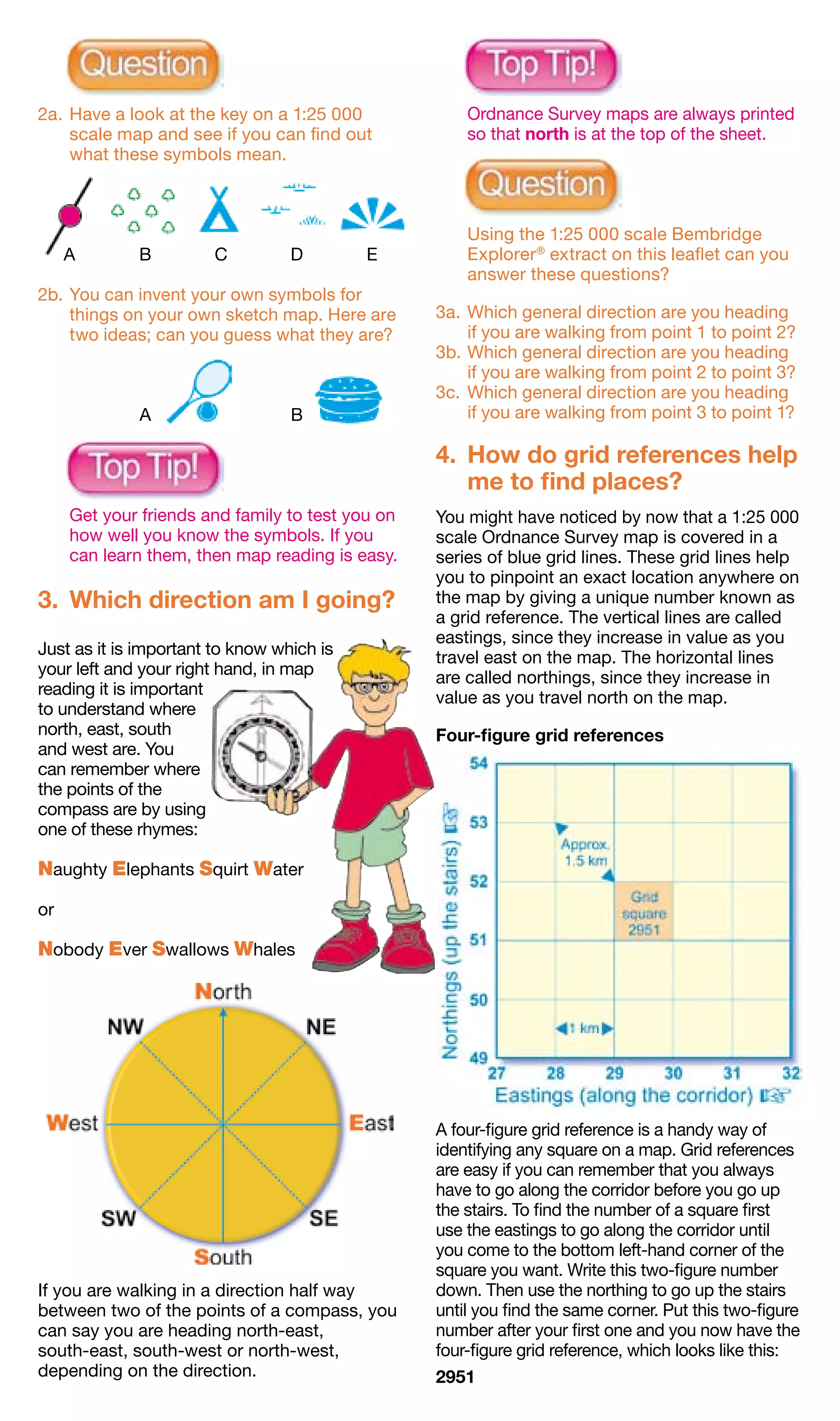
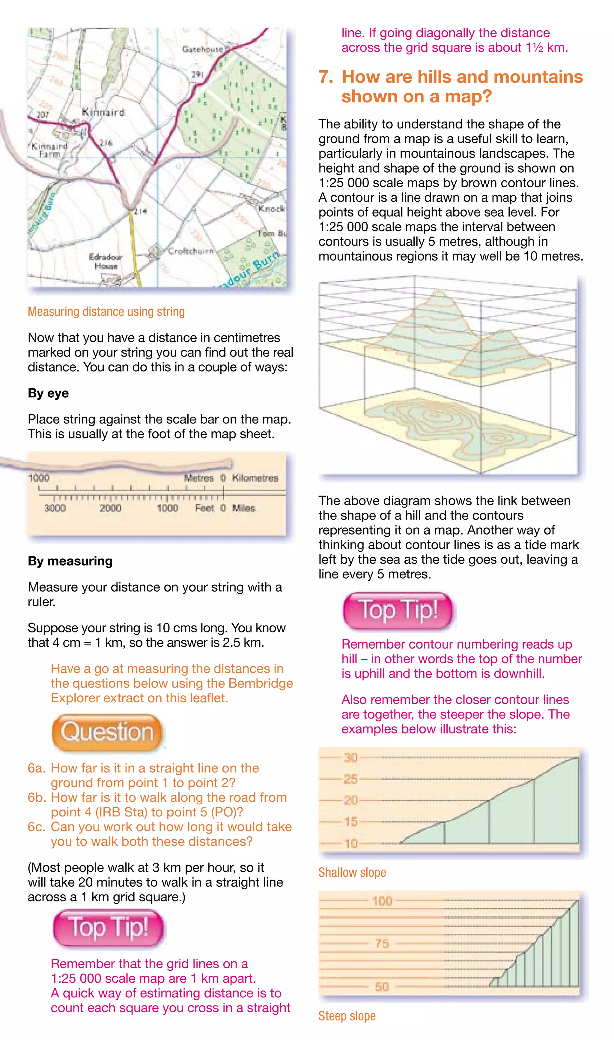
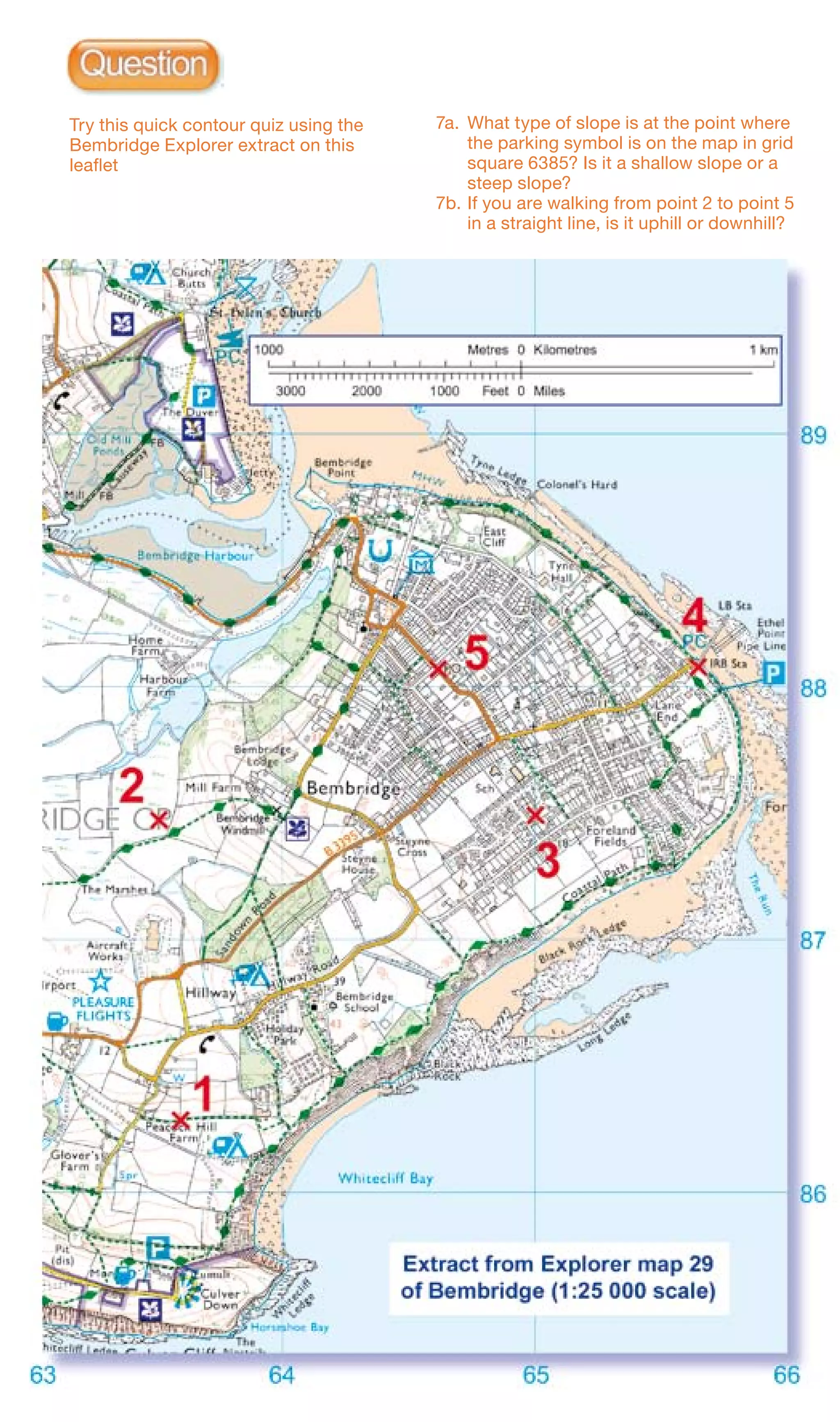
SlideShare a Scribd company logo
1 of 12
Download to read offline
Map reading
made easy
1.	 What is a map?
A map is simply a drawing or picture (in 2-D)
of a landscape or area of a country (in 3-D).
It could be anything from a sketch map for a
visitor to find your school to
a detailed map of a town
centre or mountain
range.


Using a map you can
visualise in your mind
what the place looks like
that you are going to,
and you can see what
landmarks and features
you will pass on the way
to your destination. Maps                        1:25 000 scale extract showing Snowdon, the highest
mean you know what to                            mountain in Wales
expect, and they help
you to know you are
going in the right direction to arrive at your
destination safely and quickly.
                                                 	   Why not try drawing your own map
                                                     to show a friend the route from your
                                                     house to school, showing buildings and
                                                     landmarks you pass on the way?


                                                 	   Have a look at a 1:25 000 scale map to
                                                     give you some ideas of what you could
                                                     draw if you are slightly unsure.

                                                 2.	 What are all the different
                                                     symbols?
                                                                           When drawing a map,
                                                                            you will find that you
                                                                             have to label lots of
                                                                            things you draw, such
                                                                                 as a shop or a
                                                                                       church, so
Sketch map of a school                                                                      other
                                                                                             people
                                                                                             can tell
                                                                                    what they are.
                                                                              If Ordnance Survey
                                                                               had to do this on all
                                                                               maps there would
                                                                               be too much
                                                                               writing and it would
                                                                                be very confusing.
                                                                                  The way we get
                                                                                   around this
                                                 problem is by using different shapes, colours
                                                 and symbols to show all the roads, buildings
                                                 and rivers and other interesting things in our
                                                 landscape. Maps may even show you things
                                                 you never even knew were there!

                                                 Maps usually have a key that explains the
                                                 symbols and their meanings. If you find a
                                                 symbol on the map that you don’t know,
1:25 000 scale extract showing part of London    simply look it up in the key.
2a.	Have a look at the key on a 1:25 000          	   Ordnance Survey maps are always printed
    scale map and see if you can find out             so that north is at the top of the sheet.
    what these symbols mean.


                                                  	   Using the 1:25 000 scale Bembridge
	    A	      B	        C	         D	       E          Explorer ® extract on this leaflet can you
                                                      answer these questions?
2b.	You can invent your own symbols for
    things on your own sketch map. Here are       3a.	 Which general direction are you heading
    two ideas; can you guess what they are?            if you are walking from point 1 to point 2?
                                                  3b.	Which general direction are you heading
                                                       if you are walking from point 2 to point 3?
                                                  3c.	 Which general direction are you heading
		           A		                  B                    if you are walking from point 3 to point 1?

                                                  4.	 How do grid references help
                                                      me to find places?
	    Get your friends and family to test you on   You might have noticed by now that a 1:25 000
     how well you know the symbols. If you        scale Ordnance Survey map is covered in a
     can learn them, then map reading is easy.    series of blue grid lines. These grid lines help
                                                  you to pinpoint an exact location anywhere on
3.	 Which direction am I going?                   the map by giving a unique number known as
                                                  a grid reference. The vertical lines are called
                                                  eastings, since they increase in value as you
Just as it is important to know which is          travel east on the map. The horizontal lines
your left and your right hand, in map             are called northings, since they increase in
reading it is important                           value as you travel north on the map.
to understand where
north, east, south                                Four-figure grid references
and west are. You
can remember where
the points of the
compass are by using
one of these rhymes:

Naughty Elephants Squirt Water

or

Nobody Ever Swallows Whales


                                                  A four-figure grid reference is a handy way of
                                                  identifying any square on a map. Grid references
                                                  are easy if you can remember that you always
                                                  have to go along the corridor before you go up
                                                  the stairs. To find the number of a square first
                                                  use the eastings to go along the corridor until
                                                  you come to the bottom left-hand corner of the
                                                  square you want. Write this two-figure number
If you are walking in a direction half way        down. Then use the northing to go up the stairs
between two of the points of a compass, you       until you find the same corner. Put this two-figure
can say you are heading north-east,               number after your first one and you now have the
south-east, south-west or north-west,             four-figure grid reference, which looks like this:
depending on the direction.                       2951
Now imagine this square is divided up into
                                                                     100 tiny squares with 10 squares along
                                                                     each side. Still remembering to go along the
                                                                     corridor and up the stairs, work out the extra
	    Always remember: Along the corridor and
                                                                     numbers you need and put them into your
     then up the stairs.
                                                                     four-figure grid reference like this:

                                                                     625 333

4a.	Can you work out the four-figure grid
    references for the following examples?
                                                                     4e.	Can you work out the six-figure grid
	 A	..................	 B	..................	 C	..................       references for the following examples?

                                                                     	 A	..................	 B	..................	 C	..................


	    Using the Bembridge Explorer extract on
     this leaflet, can you answer these questions?

4b.	What is the name of the school in grid
     square 6486?                                                    	    Using the Bembridge Explorer extract
4c.	 What is the name of the named building in                            on this leaflet can you answer these
     grid square 6488?                                                    questions?
4d.	What grid square is Black Rock found in?
                                                                     4f.	 What is at grid reference 648876?
Six-figure grid references                                           4g.	What would you be doing at grid
                                                                          reference 644885?
If you want to pinpoint an exact place on a                          4h.	What building is to be found at grid
map, such as your own house, you will need                                reference 643882?
to use a six-figure grid reference. First find the
four-figure grid reference for the square and
write it down with a space after each set of
numbers, like this:
62_ 33_                                                              	    When giving directions you can
                                                                          provide even more accuracy
                                                                          to your grid reference
                                                                          by stating a
                                                                          nearby
                                                                          landmark
                                                                          or feature.
                                                                          For example,
                                                                          on the Bembridge
                                                                          Explorer extract I
                                                                          am at grid reference
                                                                          644874, at the
                                                                          crossroads.
5.	 What is
	 scale?
The scale of a map
shows how much you
would have to enlarge
your map to get the
actual size of the piece
of land you are looking
at. For example, your
map has a scale of
1:25 000, which means
that every 1 cm on the                               1: 250 000 scale OS Travel Map – Road extract
map represents
25 000 of those same units of measurement
on the ground (for example, 25 000 cm = 250
metres).

That might sound a bit complicated, but              5.	 Is a 1:250 000 scale map useful for
Ordnance Survey maps have been designed                  walking or driving?
to make understanding scale easy. Look at
the front of a 1:25 000 scale map and you will
see that the scale has been written out for you
like this:

4 cm to 1 km

This means that every 4 cm on a map = 1 km
in real life. To make it even easier, the grid
lines are exactly 4 cm apart, so every square
is 1 km by 1 km.

Maps are made at different scales for
different purposes. The 1:25 000 scale map
is very useful for walking, but if you use it in a
car you will quickly drive off the edge! On the
other hand, maps at 1:250 000 scale (note
the extra zero) show lots more land but in far
less detail.
                                                     6.	 How do we measure
                                                         distance?
                                                     It is always important to know how far you
                                                     have to travel and how long it is going
                                                     to take you. By measuring a distance on
                                                     your map, you can work out how far that
                                                     is in reality. You can measure this distance
                                                     either in a straight line (as the crow flies) or
                                                     following a winding route such as a country
                                                     lane. To get this information from a map is
                                                     very easy.

                                                     Here is a way of doing it:

                                                     You can measure between two points by using
                                                     a piece of thin string. If you are measuring the
                                                     distance in a straight line, then simply stretch
                                                     the string between the two points. If you are
                                                     following a road or track that is not straight,
                                                     bend the string to follow the exact shape until
1:25 000 scale Explorer extract                      you reach the second point.
line. If going diagonally the distance
                                                      across the grid square is about 1½ km.

                                                  7.	 How are hills and mountains
                                                      shown on a map?
                                                  The ability to understand the shape of the
                                                  ground from a map is a useful skill to learn,
                                                  particularly in mountainous landscapes. The
                                                  height and shape of the ground is shown on
                                                  1:25 000 scale maps by brown contour lines.
                                                  A contour is a line drawn on a map that joins
                                                  points of equal height above sea level. For
                                                  1:25 000 scale maps the interval between
                                                  contours is usually 5 metres, although in
                                                  mountainous regions it may well be 10 metres.


Measuring distance using string

Now that you have a distance in centimetres
marked on your string you can find out the real
distance. You can do this in a couple of ways:

By eye

Place string against the scale bar on the map.
This is usually at the foot of the map sheet.


                                                  The above diagram shows the link between
                                                  the shape of a hill and the contours
                                                  representing it on a map. Another way of
                                                  thinking about contour lines is as a tide mark
By measuring                                      left by the sea as the tide goes out, leaving a
                                                  line every 5 metres.
Measure your distance on your string with a
ruler.

Suppose your string is 10 cms long. You know
that 4 cm = 1 km, so the answer is 2.5 km.        	   Remember contour numbering reads up
                                                      hill – in other words the top of the number
	   Have a go at measuring the distances in           is uphill and the bottom is downhill.
    the questions below using the Bembridge
    Explorer extract on this leaflet.             	   Also remember the closer contour lines
                                                      are together, the steeper the slope. The
                                                      examples below illustrate this:


6a.	How far is it in a straight line on the
    ground from point 1 to point 2?
6b.	How far is it to walk along the road from
    point 4 (IRB Sta) to point 5 (PO)?
6c.	Can you work out how long it would take
    you to walk both these distances?

(Most people walk at 3 km per hour, so it         Shallow slope
will take 20 minutes to walk in a straight line
across a 1 km grid square.)


	   Remember that the grid lines on a
    1:25 000 scale map are 1 km apart.
    A quick way of estimating distance is to
    count each square you cross in a straight
                                                  Steep slope
Try this quick contour quiz using the   7a.	 What type of slope is at the point where
    Bembridge Explorer extract on this           the parking symbol is on the map in grid
    leaflet                                      square 6385? Is it a shallow slope or a
                                                 steep slope?
                                            7b.	If you are walking from point 2 to point 5
                                                 in a straight line, is it uphill or downhill?
It’s free, it’s fun, it’s


www.ordnancesurvey.co.uk/mapzone

Unravel the mystery of maps with a
visit to the virtual world of MapZone®.
It’s free, fun and packed with facts
to help you learn all about maps and
map reading.
www.ordnancesurvey.co.uk/mapzone
Take aim with our games
Check out our brilliant selection of free and fun games. We regularly
add new puzzles, so don’t forget to call back again soon.
Hands up for Homework Help
Banish homework hassles and snap up some map skills with our
interactive guide. Whether you’re testing your MapAbility in the
MapTivity quiz or taking a seat in our MapSchool, Homework Help
takes the mystery out of mapping.


The future is GIS Zone
Heard about geographical information systems (GIS)? Possibly not, but
they affect your life every day. Get ahead of the game and learn about
them in a fun way.
Mission control
Want to have fun and also prove that you can make the decisions that
matter? Use GIS to sift the evidence in our six exciting missions that
we have specially created for you.


GIS is coming to a screen near you
The future of GIS may be on your mobile phone screen. Find out about
this and other developments that are changing the way we see things.
Maps can be great fun – and they can lead you to all sorts of discoveries. They can help
you get to know an area really well, because they pinpoint interesting places that are
often hidden away, which you might otherwise never find. They can also help you find
different routes to places you already know.

To be sure you are not missing anything important you need to know about map symbols,
scale, direction and distance. Knowing about these will help you unlock the secrets of
maps. This leaflet explains the main things you need to understand, especially when
using Ordnance Survey Explorer maps at 1:25 000 scale.

Maps can also help you in your geography, history, environmental science or citizenship
classes – but they can provide entertainment, too. Find out how by discovering the games,
quizzes and competitions featured on the web at www.ordnancesurvey.co.uk/mapzone.

Happy exploring!


Vanessa Lawrence
Director General and Chief Executive
Ordnance Survey


Contact details
Ordnance Survey Customer HelpLine
Phone: 08456 05 05 05
Fax: 023 8079 2615
Welsh Language HelpLine: 08456 05 05 04
Website: www.ordnancesurvey.co.uk
Email: customerservices@ordnancesurvey.co.uk


This leaflet was produced in association with The Expedition Company Ltd.

D02518 0505 (MR1E)


 approximately; points 4 to 5 = 25 minutes approximately. 7a. It is a steep slope. 7b. Uphill.
 or dome. 5. Driving. 6a. 1 180 metres or 1.18 km. 6b. 1 250 metres or 1.25 km. 6c. Points 1 to 2 = 24 minutes
 6486. 4e. A. 615335. B. 635324. C. 632341. 4f. School. 4g. Horse riding. 4h. Place of worship – with spire, minaret
 bar. 3a. North. 3b. East. 3c. South-west. 4a. A. 8326. B. 8424. C. 8523. 4b. Bembridge School. 4c. East Cliff. 4d.
 2a. A. Railway station. B. Orchard. C. Camp site. D. Marsh, reeds or saltings. E. Viewpoint. 2b. A. Sport. B. Burger

                                                                                             Answers to questions

More Related Content

Similar to Easypeasy

map-reading-made-easy (1).pdf
map-reading-made-easy (1).pdfmap-reading-made-easy (1).pdf
map-reading-made-easy (1).pdfQanitaTariq
 
Geography - Maps - Class 6
Geography - Maps - Class 6Geography - Maps - Class 6
Geography - Maps - Class 6Ankita Nandi
 
Directions and Maps EVS Worksheets CBSE Class 2 - EVS Worksheet for class 2.pdf
Directions and Maps EVS Worksheets CBSE Class 2 - EVS Worksheet for class 2.pdfDirections and Maps EVS Worksheets CBSE Class 2 - EVS Worksheet for class 2.pdf
Directions and Maps EVS Worksheets CBSE Class 2 - EVS Worksheet for class 2.pdfTakshila Learning
 
Geography map skill (all you need to know)
Geography map skill (all you need to know)Geography map skill (all you need to know)
Geography map skill (all you need to know)jamesadam2001
 
map-reading (1).pdf
map-reading (1).pdfmap-reading (1).pdf
map-reading (1).pdfQanitaTariq
 
1017 notes on maps and mapping
1017 notes on maps and mapping1017 notes on maps and mapping
1017 notes on maps and mappingJulian Swindell
 
Mapskillsrevision 090409091745-phpapp01 2
Mapskillsrevision 090409091745-phpapp01 2Mapskillsrevision 090409091745-phpapp01 2
Mapskillsrevision 090409091745-phpapp01 2MOSIMANE MOTSAPI
 
Mapskills Revision
Mapskills RevisionMapskills Revision
Mapskills RevisionEcumene
 
Elements of a map for 5th_djdhir
Elements of a map for 5th_djdhirElements of a map for 5th_djdhir
Elements of a map for 5th_djdhirdjdhir
 
Geo skills 2 -Parts of a Map
Geo skills 2 -Parts of a MapGeo skills 2 -Parts of a Map
Geo skills 2 -Parts of a Maprenaoregan
 

Similar to Easypeasy (20)

Maps
MapsMaps
Maps
 
map-reading-made-easy (1).pdf
map-reading-made-easy (1).pdfmap-reading-made-easy (1).pdf
map-reading-made-easy (1).pdf
 
Geography - Maps - Class 6
Geography - Maps - Class 6Geography - Maps - Class 6
Geography - Maps - Class 6
 
Mapping
MappingMapping
Mapping
 
Maps and globes
Maps and globesMaps and globes
Maps and globes
 
Mapping space around us
Mapping space around usMapping space around us
Mapping space around us
 
Chapter 4 maps ppt
Chapter 4 maps pptChapter 4 maps ppt
Chapter 4 maps ppt
 
Maps and location
Maps and locationMaps and location
Maps and location
 
Scale for web
Scale for webScale for web
Scale for web
 
Directions and Maps EVS Worksheets CBSE Class 2 - EVS Worksheet for class 2.pdf
Directions and Maps EVS Worksheets CBSE Class 2 - EVS Worksheet for class 2.pdfDirections and Maps EVS Worksheets CBSE Class 2 - EVS Worksheet for class 2.pdf
Directions and Maps EVS Worksheets CBSE Class 2 - EVS Worksheet for class 2.pdf
 
Geography map skill (all you need to know)
Geography map skill (all you need to know)Geography map skill (all you need to know)
Geography map skill (all you need to know)
 
Map symbols l1a
Map symbols   l1aMap symbols   l1a
Map symbols l1a
 
map-reading (1).pdf
map-reading (1).pdfmap-reading (1).pdf
map-reading (1).pdf
 
Workshop one
Workshop oneWorkshop one
Workshop one
 
1017 notes on maps and mapping
1017 notes on maps and mapping1017 notes on maps and mapping
1017 notes on maps and mapping
 
Mapskillsrevision 090409091745-phpapp01 2
Mapskillsrevision 090409091745-phpapp01 2Mapskillsrevision 090409091745-phpapp01 2
Mapskillsrevision 090409091745-phpapp01 2
 
Mapskills Revision
Mapskills RevisionMapskills Revision
Mapskills Revision
 
Map reading
Map readingMap reading
Map reading
 
Elements of a map for 5th_djdhir
Elements of a map for 5th_djdhirElements of a map for 5th_djdhir
Elements of a map for 5th_djdhir
 
Geo skills 2 -Parts of a Map
Geo skills 2 -Parts of a MapGeo skills 2 -Parts of a Map
Geo skills 2 -Parts of a Map
 

More from cooperativerosa

Expressions to introduce points
Expressions to introduce pointsExpressions to introduce points
Expressions to introduce pointscooperativerosa
 
Compare and contrast essay guidelines
Compare and contrast essay guidelinesCompare and contrast essay guidelines
Compare and contrast essay guidelinescooperativerosa
 
Model thesis statements for problem
Model thesis statements for problemModel thesis statements for problem
Model thesis statements for problemcooperativerosa
 
Model thesis statements for compare and contrast essays
Model thesis statements for compare and contrast essaysModel thesis statements for compare and contrast essays
Model thesis statements for compare and contrast essayscooperativerosa
 
Buying a book chain dialogue
Buying a book chain dialogueBuying a book chain dialogue
Buying a book chain dialoguecooperativerosa
 
Orientación académica y profesional ii
Orientación académica y profesional iiOrientación académica y profesional ii
Orientación académica y profesional iicooperativerosa
 
Orientación académica y profesional i
Orientación académica y profesional iOrientación académica y profesional i
Orientación académica y profesional icooperativerosa
 
(Explicación entrada blog)
(Explicación entrada blog)(Explicación entrada blog)
(Explicación entrada blog)cooperativerosa
 
What would you say in these circumstances
What would you say in these circumstancesWhat would you say in these circumstances
What would you say in these circumstancescooperativerosa
 
Can you survive in the mountain
Can you survive in the mountainCan you survive in the mountain
Can you survive in the mountaincooperativerosa
 
Can you survive in the mountain
Can you survive in the mountainCan you survive in the mountain
Can you survive in the mountaincooperativerosa
 
Things to do in a national park
Things to do in a national parkThings to do in a national park
Things to do in a national parkcooperativerosa
 

More from cooperativerosa (19)

Expressions to introduce points
Expressions to introduce pointsExpressions to introduce points
Expressions to introduce points
 
Compare and contrast essay guidelines
Compare and contrast essay guidelinesCompare and contrast essay guidelines
Compare and contrast essay guidelines
 
Model thesis statements for problem
Model thesis statements for problemModel thesis statements for problem
Model thesis statements for problem
 
Model thesis statements for compare and contrast essays
Model thesis statements for compare and contrast essaysModel thesis statements for compare and contrast essays
Model thesis statements for compare and contrast essays
 
Buying a book chain dialogue
Buying a book chain dialogueBuying a book chain dialogue
Buying a book chain dialogue
 
Presentations 1.2
Presentations 1.2Presentations 1.2
Presentations 1.2
 
Presentations 1
Presentations 1Presentations 1
Presentations 1
 
Orientación académica y profesional ii
Orientación académica y profesional iiOrientación académica y profesional ii
Orientación académica y profesional ii
 
Orientación académica y profesional i
Orientación académica y profesional iOrientación académica y profesional i
Orientación académica y profesional i
 
Presentación1
Presentación1Presentación1
Presentación1
 
Institute
InstituteInstitute
Institute
 
Supers
SupersSupers
Supers
 
(Explicación entrada blog)
(Explicación entrada blog)(Explicación entrada blog)
(Explicación entrada blog)
 
Topomapsymbols
TopomapsymbolsTopomapsymbols
Topomapsymbols
 
25kenglishlegend08
25kenglishlegend0825kenglishlegend08
25kenglishlegend08
 
What would you say in these circumstances
What would you say in these circumstancesWhat would you say in these circumstances
What would you say in these circumstances
 
Can you survive in the mountain
Can you survive in the mountainCan you survive in the mountain
Can you survive in the mountain
 
Can you survive in the mountain
Can you survive in the mountainCan you survive in the mountain
Can you survive in the mountain
 
Things to do in a national park
Things to do in a national parkThings to do in a national park
Things to do in a national park
 

Recently uploaded

Artificial intelligence in the post-deep learning era
Artificial intelligence in the post-deep learning eraArtificial intelligence in the post-deep learning era
Artificial intelligence in the post-deep learning eraDeakin University
 
Kotlin Multiplatform & Compose Multiplatform - Starter kit for pragmatics
Kotlin Multiplatform & Compose Multiplatform - Starter kit for pragmaticsKotlin Multiplatform & Compose Multiplatform - Starter kit for pragmatics
Kotlin Multiplatform & Compose Multiplatform - Starter kit for pragmaticscarlostorres15106
 
Swan(sea) Song – personal research during my six years at Swansea ... and bey...
Swan(sea) Song – personal research during my six years at Swansea ... and bey...Swan(sea) Song – personal research during my six years at Swansea ... and bey...
Swan(sea) Song – personal research during my six years at Swansea ... and bey...Alan Dix
 
Pigging Solutions Piggable Sweeping Elbows
Pigging Solutions Piggable Sweeping ElbowsPigging Solutions Piggable Sweeping Elbows
Pigging Solutions Piggable Sweeping ElbowsPigging Solutions
 
08448380779 Call Girls In Civil Lines Women Seeking Men
08448380779 Call Girls In Civil Lines Women Seeking Men08448380779 Call Girls In Civil Lines Women Seeking Men
08448380779 Call Girls In Civil Lines Women Seeking MenDelhi Call girls
 
Benefits Of Flutter Compared To Other Frameworks
Benefits Of Flutter Compared To Other FrameworksBenefits Of Flutter Compared To Other Frameworks
Benefits Of Flutter Compared To Other FrameworksSoftradix Technologies
 
#StandardsGoals for 2024: What’s new for BISAC - Tech Forum 2024
#StandardsGoals for 2024: What’s new for BISAC - Tech Forum 2024#StandardsGoals for 2024: What’s new for BISAC - Tech Forum 2024
#StandardsGoals for 2024: What’s new for BISAC - Tech Forum 2024BookNet Canada
 
Key Features Of Token Development (1).pptx
Key  Features Of Token  Development (1).pptxKey  Features Of Token  Development (1).pptx
Key Features Of Token Development (1).pptxLBM Solutions
 
SQL Database Design For Developers at php[tek] 2024
SQL Database Design For Developers at php[tek] 2024SQL Database Design For Developers at php[tek] 2024
SQL Database Design For Developers at php[tek] 2024Scott Keck-Warren
 
Pigging Solutions in Pet Food Manufacturing
Pigging Solutions in Pet Food ManufacturingPigging Solutions in Pet Food Manufacturing
Pigging Solutions in Pet Food ManufacturingPigging Solutions
 
GenCyber Cyber Security Day Presentation
GenCyber Cyber Security Day PresentationGenCyber Cyber Security Day Presentation
GenCyber Cyber Security Day PresentationMichael W. Hawkins
 
Automating Business Process via MuleSoft Composer | Bangalore MuleSoft Meetup...
Automating Business Process via MuleSoft Composer | Bangalore MuleSoft Meetup...Automating Business Process via MuleSoft Composer | Bangalore MuleSoft Meetup...
Automating Business Process via MuleSoft Composer | Bangalore MuleSoft Meetup...shyamraj55
 
WhatsApp 9892124323 ✓Call Girls In Kalyan ( Mumbai ) secure service
WhatsApp 9892124323 ✓Call Girls In Kalyan ( Mumbai ) secure serviceWhatsApp 9892124323 ✓Call Girls In Kalyan ( Mumbai ) secure service
WhatsApp 9892124323 ✓Call Girls In Kalyan ( Mumbai ) secure servicePooja Nehwal
 
Hyderabad Call Girls Khairatabad ✨ 7001305949 ✨ Cheap Price Your Budget
Hyderabad Call Girls Khairatabad ✨ 7001305949 ✨ Cheap Price Your BudgetHyderabad Call Girls Khairatabad ✨ 7001305949 ✨ Cheap Price Your Budget
Hyderabad Call Girls Khairatabad ✨ 7001305949 ✨ Cheap Price Your BudgetEnjoy Anytime
 
Install Stable Diffusion in windows machine
Install Stable Diffusion in windows machineInstall Stable Diffusion in windows machine
Install Stable Diffusion in windows machinePadma Pradeep
 
08448380779 Call Girls In Diplomatic Enclave Women Seeking Men
08448380779 Call Girls In Diplomatic Enclave Women Seeking Men08448380779 Call Girls In Diplomatic Enclave Women Seeking Men
08448380779 Call Girls In Diplomatic Enclave Women Seeking MenDelhi Call girls
 
Transcript: #StandardsGoals for 2024: What’s new for BISAC - Tech Forum 2024
Transcript: #StandardsGoals for 2024: What’s new for BISAC - Tech Forum 2024Transcript: #StandardsGoals for 2024: What’s new for BISAC - Tech Forum 2024
Transcript: #StandardsGoals for 2024: What’s new for BISAC - Tech Forum 2024BookNet Canada
 
Breaking the Kubernetes Kill Chain: Host Path Mount
Breaking the Kubernetes Kill Chain: Host Path MountBreaking the Kubernetes Kill Chain: Host Path Mount
Breaking the Kubernetes Kill Chain: Host Path MountPuma Security, LLC
 

Recently uploaded (20)

Artificial intelligence in the post-deep learning era
Artificial intelligence in the post-deep learning eraArtificial intelligence in the post-deep learning era
Artificial intelligence in the post-deep learning era
 
Kotlin Multiplatform & Compose Multiplatform - Starter kit for pragmatics
Kotlin Multiplatform & Compose Multiplatform - Starter kit for pragmaticsKotlin Multiplatform & Compose Multiplatform - Starter kit for pragmatics
Kotlin Multiplatform & Compose Multiplatform - Starter kit for pragmatics
 
E-Vehicle_Hacking_by_Parul Sharma_null_owasp.pptx
E-Vehicle_Hacking_by_Parul Sharma_null_owasp.pptxE-Vehicle_Hacking_by_Parul Sharma_null_owasp.pptx
E-Vehicle_Hacking_by_Parul Sharma_null_owasp.pptx
 
Swan(sea) Song – personal research during my six years at Swansea ... and bey...
Swan(sea) Song – personal research during my six years at Swansea ... and bey...Swan(sea) Song – personal research during my six years at Swansea ... and bey...
Swan(sea) Song – personal research during my six years at Swansea ... and bey...
 
Pigging Solutions Piggable Sweeping Elbows
Pigging Solutions Piggable Sweeping ElbowsPigging Solutions Piggable Sweeping Elbows
Pigging Solutions Piggable Sweeping Elbows
 
08448380779 Call Girls In Civil Lines Women Seeking Men
08448380779 Call Girls In Civil Lines Women Seeking Men08448380779 Call Girls In Civil Lines Women Seeking Men
08448380779 Call Girls In Civil Lines Women Seeking Men
 
Benefits Of Flutter Compared To Other Frameworks
Benefits Of Flutter Compared To Other FrameworksBenefits Of Flutter Compared To Other Frameworks
Benefits Of Flutter Compared To Other Frameworks
 
#StandardsGoals for 2024: What’s new for BISAC - Tech Forum 2024
#StandardsGoals for 2024: What’s new for BISAC - Tech Forum 2024#StandardsGoals for 2024: What’s new for BISAC - Tech Forum 2024
#StandardsGoals for 2024: What’s new for BISAC - Tech Forum 2024
 
Key Features Of Token Development (1).pptx
Key  Features Of Token  Development (1).pptxKey  Features Of Token  Development (1).pptx
Key Features Of Token Development (1).pptx
 
SQL Database Design For Developers at php[tek] 2024
SQL Database Design For Developers at php[tek] 2024SQL Database Design For Developers at php[tek] 2024
SQL Database Design For Developers at php[tek] 2024
 
Pigging Solutions in Pet Food Manufacturing
Pigging Solutions in Pet Food ManufacturingPigging Solutions in Pet Food Manufacturing
Pigging Solutions in Pet Food Manufacturing
 
GenCyber Cyber Security Day Presentation
GenCyber Cyber Security Day PresentationGenCyber Cyber Security Day Presentation
GenCyber Cyber Security Day Presentation
 
Automating Business Process via MuleSoft Composer | Bangalore MuleSoft Meetup...
Automating Business Process via MuleSoft Composer | Bangalore MuleSoft Meetup...Automating Business Process via MuleSoft Composer | Bangalore MuleSoft Meetup...
Automating Business Process via MuleSoft Composer | Bangalore MuleSoft Meetup...
 
WhatsApp 9892124323 ✓Call Girls In Kalyan ( Mumbai ) secure service
WhatsApp 9892124323 ✓Call Girls In Kalyan ( Mumbai ) secure serviceWhatsApp 9892124323 ✓Call Girls In Kalyan ( Mumbai ) secure service
WhatsApp 9892124323 ✓Call Girls In Kalyan ( Mumbai ) secure service
 
Hyderabad Call Girls Khairatabad ✨ 7001305949 ✨ Cheap Price Your Budget
Hyderabad Call Girls Khairatabad ✨ 7001305949 ✨ Cheap Price Your BudgetHyderabad Call Girls Khairatabad ✨ 7001305949 ✨ Cheap Price Your Budget
Hyderabad Call Girls Khairatabad ✨ 7001305949 ✨ Cheap Price Your Budget
 
Install Stable Diffusion in windows machine
Install Stable Diffusion in windows machineInstall Stable Diffusion in windows machine
Install Stable Diffusion in windows machine
 
08448380779 Call Girls In Diplomatic Enclave Women Seeking Men
08448380779 Call Girls In Diplomatic Enclave Women Seeking Men08448380779 Call Girls In Diplomatic Enclave Women Seeking Men
08448380779 Call Girls In Diplomatic Enclave Women Seeking Men
 
Transcript: #StandardsGoals for 2024: What’s new for BISAC - Tech Forum 2024
Transcript: #StandardsGoals for 2024: What’s new for BISAC - Tech Forum 2024Transcript: #StandardsGoals for 2024: What’s new for BISAC - Tech Forum 2024
Transcript: #StandardsGoals for 2024: What’s new for BISAC - Tech Forum 2024
 
The transition to renewables in India.pdf
The transition to renewables in India.pdfThe transition to renewables in India.pdf
The transition to renewables in India.pdf
 
Breaking the Kubernetes Kill Chain: Host Path Mount
Breaking the Kubernetes Kill Chain: Host Path MountBreaking the Kubernetes Kill Chain: Host Path Mount
Breaking the Kubernetes Kill Chain: Host Path Mount
 

Easypeasy

  • 2. 1. What is a map? A map is simply a drawing or picture (in 2-D) of a landscape or area of a country (in 3-D). It could be anything from a sketch map for a visitor to find your school to a detailed map of a town centre or mountain range. Using a map you can visualise in your mind what the place looks like that you are going to, and you can see what landmarks and features you will pass on the way to your destination. Maps 1:25 000 scale extract showing Snowdon, the highest mean you know what to mountain in Wales expect, and they help you to know you are going in the right direction to arrive at your destination safely and quickly. Why not try drawing your own map to show a friend the route from your house to school, showing buildings and landmarks you pass on the way? Have a look at a 1:25 000 scale map to give you some ideas of what you could draw if you are slightly unsure. 2. What are all the different symbols? When drawing a map, you will find that you have to label lots of things you draw, such as a shop or a church, so Sketch map of a school other people can tell what they are. If Ordnance Survey had to do this on all maps there would be too much writing and it would be very confusing. The way we get around this problem is by using different shapes, colours and symbols to show all the roads, buildings and rivers and other interesting things in our landscape. Maps may even show you things you never even knew were there! Maps usually have a key that explains the symbols and their meanings. If you find a symbol on the map that you don’t know, 1:25 000 scale extract showing part of London simply look it up in the key.
  • 3. 2a. Have a look at the key on a 1:25 000 Ordnance Survey maps are always printed scale map and see if you can find out so that north is at the top of the sheet. what these symbols mean. Using the 1:25 000 scale Bembridge A B C D E Explorer ® extract on this leaflet can you answer these questions? 2b. You can invent your own symbols for things on your own sketch map. Here are 3a. Which general direction are you heading two ideas; can you guess what they are? if you are walking from point 1 to point 2? 3b. Which general direction are you heading if you are walking from point 2 to point 3? 3c. Which general direction are you heading A B if you are walking from point 3 to point 1? 4. How do grid references help me to find places? Get your friends and family to test you on You might have noticed by now that a 1:25 000 how well you know the symbols. If you scale Ordnance Survey map is covered in a can learn them, then map reading is easy. series of blue grid lines. These grid lines help you to pinpoint an exact location anywhere on 3. Which direction am I going? the map by giving a unique number known as a grid reference. The vertical lines are called eastings, since they increase in value as you Just as it is important to know which is travel east on the map. The horizontal lines your left and your right hand, in map are called northings, since they increase in reading it is important value as you travel north on the map. to understand where north, east, south Four-figure grid references and west are. You can remember where the points of the compass are by using one of these rhymes: Naughty Elephants Squirt Water or Nobody Ever Swallows Whales A four-figure grid reference is a handy way of identifying any square on a map. Grid references are easy if you can remember that you always have to go along the corridor before you go up the stairs. To find the number of a square first use the eastings to go along the corridor until you come to the bottom left-hand corner of the square you want. Write this two-figure number If you are walking in a direction half way down. Then use the northing to go up the stairs between two of the points of a compass, you until you find the same corner. Put this two-figure can say you are heading north-east, number after your first one and you now have the south-east, south-west or north-west, four-figure grid reference, which looks like this: depending on the direction. 2951
  • 4. Now imagine this square is divided up into 100 tiny squares with 10 squares along each side. Still remembering to go along the corridor and up the stairs, work out the extra Always remember: Along the corridor and numbers you need and put them into your then up the stairs. four-figure grid reference like this: 625 333 4a. Can you work out the four-figure grid references for the following examples? 4e. Can you work out the six-figure grid A .................. B .................. C .................. references for the following examples? A .................. B .................. C .................. Using the Bembridge Explorer extract on this leaflet, can you answer these questions? 4b. What is the name of the school in grid square 6486? Using the Bembridge Explorer extract 4c. What is the name of the named building in on this leaflet can you answer these grid square 6488? questions? 4d. What grid square is Black Rock found in? 4f. What is at grid reference 648876? Six-figure grid references 4g. What would you be doing at grid reference 644885? If you want to pinpoint an exact place on a 4h. What building is to be found at grid map, such as your own house, you will need reference 643882? to use a six-figure grid reference. First find the four-figure grid reference for the square and write it down with a space after each set of numbers, like this: 62_ 33_ When giving directions you can provide even more accuracy to your grid reference by stating a nearby landmark or feature. For example, on the Bembridge Explorer extract I am at grid reference 644874, at the crossroads.
  • 5. 5. What is scale? The scale of a map shows how much you would have to enlarge your map to get the actual size of the piece of land you are looking at. For example, your map has a scale of 1:25 000, which means that every 1 cm on the 1: 250 000 scale OS Travel Map – Road extract map represents 25 000 of those same units of measurement on the ground (for example, 25 000 cm = 250 metres). That might sound a bit complicated, but 5. Is a 1:250 000 scale map useful for Ordnance Survey maps have been designed walking or driving? to make understanding scale easy. Look at the front of a 1:25 000 scale map and you will see that the scale has been written out for you like this: 4 cm to 1 km This means that every 4 cm on a map = 1 km in real life. To make it even easier, the grid lines are exactly 4 cm apart, so every square is 1 km by 1 km. Maps are made at different scales for different purposes. The 1:25 000 scale map is very useful for walking, but if you use it in a car you will quickly drive off the edge! On the other hand, maps at 1:250 000 scale (note the extra zero) show lots more land but in far less detail. 6. How do we measure distance? It is always important to know how far you have to travel and how long it is going to take you. By measuring a distance on your map, you can work out how far that is in reality. You can measure this distance either in a straight line (as the crow flies) or following a winding route such as a country lane. To get this information from a map is very easy. Here is a way of doing it: You can measure between two points by using a piece of thin string. If you are measuring the distance in a straight line, then simply stretch the string between the two points. If you are following a road or track that is not straight, bend the string to follow the exact shape until 1:25 000 scale Explorer extract you reach the second point.
  • 6. line. If going diagonally the distance across the grid square is about 1½ km. 7. How are hills and mountains shown on a map? The ability to understand the shape of the ground from a map is a useful skill to learn, particularly in mountainous landscapes. The height and shape of the ground is shown on 1:25 000 scale maps by brown contour lines. A contour is a line drawn on a map that joins points of equal height above sea level. For 1:25 000 scale maps the interval between contours is usually 5 metres, although in mountainous regions it may well be 10 metres. Measuring distance using string Now that you have a distance in centimetres marked on your string you can find out the real distance. You can do this in a couple of ways: By eye Place string against the scale bar on the map. This is usually at the foot of the map sheet. The above diagram shows the link between the shape of a hill and the contours representing it on a map. Another way of thinking about contour lines is as a tide mark By measuring left by the sea as the tide goes out, leaving a line every 5 metres. Measure your distance on your string with a ruler. Suppose your string is 10 cms long. You know that 4 cm = 1 km, so the answer is 2.5 km. Remember contour numbering reads up hill – in other words the top of the number Have a go at measuring the distances in is uphill and the bottom is downhill. the questions below using the Bembridge Explorer extract on this leaflet. Also remember the closer contour lines are together, the steeper the slope. The examples below illustrate this: 6a. How far is it in a straight line on the ground from point 1 to point 2? 6b. How far is it to walk along the road from point 4 (IRB Sta) to point 5 (PO)? 6c. Can you work out how long it would take you to walk both these distances? (Most people walk at 3 km per hour, so it Shallow slope will take 20 minutes to walk in a straight line across a 1 km grid square.) Remember that the grid lines on a 1:25 000 scale map are 1 km apart. A quick way of estimating distance is to count each square you cross in a straight Steep slope
  • 7. Try this quick contour quiz using the 7a. What type of slope is at the point where Bembridge Explorer extract on this the parking symbol is on the map in grid leaflet square 6385? Is it a shallow slope or a steep slope? 7b. If you are walking from point 2 to point 5 in a straight line, is it uphill or downhill?
  • 8. It’s free, it’s fun, it’s www.ordnancesurvey.co.uk/mapzone Unravel the mystery of maps with a visit to the virtual world of MapZone®. It’s free, fun and packed with facts to help you learn all about maps and map reading. www.ordnancesurvey.co.uk/mapzone
  • 9. Take aim with our games Check out our brilliant selection of free and fun games. We regularly add new puzzles, so don’t forget to call back again soon.
  • 10. Hands up for Homework Help Banish homework hassles and snap up some map skills with our interactive guide. Whether you’re testing your MapAbility in the MapTivity quiz or taking a seat in our MapSchool, Homework Help takes the mystery out of mapping. The future is GIS Zone Heard about geographical information systems (GIS)? Possibly not, but they affect your life every day. Get ahead of the game and learn about them in a fun way.
  • 11. Mission control Want to have fun and also prove that you can make the decisions that matter? Use GIS to sift the evidence in our six exciting missions that we have specially created for you. GIS is coming to a screen near you The future of GIS may be on your mobile phone screen. Find out about this and other developments that are changing the way we see things.
  • 12. Maps can be great fun – and they can lead you to all sorts of discoveries. They can help you get to know an area really well, because they pinpoint interesting places that are often hidden away, which you might otherwise never find. They can also help you find different routes to places you already know. To be sure you are not missing anything important you need to know about map symbols, scale, direction and distance. Knowing about these will help you unlock the secrets of maps. This leaflet explains the main things you need to understand, especially when using Ordnance Survey Explorer maps at 1:25 000 scale. Maps can also help you in your geography, history, environmental science or citizenship classes – but they can provide entertainment, too. Find out how by discovering the games, quizzes and competitions featured on the web at www.ordnancesurvey.co.uk/mapzone. Happy exploring! Vanessa Lawrence Director General and Chief Executive Ordnance Survey Contact details Ordnance Survey Customer HelpLine Phone: 08456 05 05 05 Fax: 023 8079 2615 Welsh Language HelpLine: 08456 05 05 04 Website: www.ordnancesurvey.co.uk Email: customerservices@ordnancesurvey.co.uk This leaflet was produced in association with The Expedition Company Ltd. D02518 0505 (MR1E) approximately; points 4 to 5 = 25 minutes approximately. 7a. It is a steep slope. 7b. Uphill. or dome. 5. Driving. 6a. 1 180 metres or 1.18 km. 6b. 1 250 metres or 1.25 km. 6c. Points 1 to 2 = 24 minutes 6486. 4e. A. 615335. B. 635324. C. 632341. 4f. School. 4g. Horse riding. 4h. Place of worship – with spire, minaret bar. 3a. North. 3b. East. 3c. South-west. 4a. A. 8326. B. 8424. C. 8523. 4b. Bembridge School. 4c. East Cliff. 4d. 2a. A. Railway station. B. Orchard. C. Camp site. D. Marsh, reeds or saltings. E. Viewpoint. 2b. A. Sport. B. Burger Answers to questions