The document provides information about tsunamis, including what causes them, Hawaii's history with tsunamis, and tips for preparing for a tsunami, such as knowing evacuation zones, creating an emergency kit, and being aware of warning systems. It also explains the concept attainment strategy, which will be used in the interview to identify the specific earthquake types that cause tsunami evacuations based on key concepts around location, magnitude, depth, and inundation zones.
Running head PBAD201-1303B-03 P4IPP4IP .docxjoellemurphey
Running head: PBAD201-1303B-03 P4IP
P4IP 2
PBAD201-1303B-03 P4IP
Colorado Technical University
Instructor: Professor Knetzger
Connie Hutson
15 September 2013
PBAD201-1303B-03 P43IP
Colorado Technical University
Instructor: Professor Knetzger
Connie Hutson
15 September 2013
Earthquake Preparedness
Every disaster has different effects. It can cause permanent damage or temporary inconvenience. This research paper seeks to illustrate how to avoid terrible outcomes of unexpected earthquakes. Every disaster, if prepared for can cause less damage. An earthquake is one natural disaster that has a high rate of damage in its after effects. It is known as the abrupt and fast shaking of the ground caused as rock breaks and shifts due to the strain that has accumulated over a long period (Walker 2008). Earthquakes are one of the major disasters not anticipated, and they end up causing irreparable damage. This paper will use a sample of the San Francisco Bay area. It has a population size of 7,150,739 people as at the census taken in 2010. The Bay Area sits at border where a couple of the earth’s biggest tectonic plates intersect and pass each other. Sometimes, the boundary faults may break. Then the North American plate hurls at the Pacific Plates. This is when an earthquake occurs.
The area has had a number of earthquakes, a trend that scientists cannot take to be random. Some of the earthquakes have a magnitude of 6 and even higher. There is a high frequency of earthquakes. It is estimated that there is a 50% probability that in the next thirty years there will be more occurrences of the same magnitude. Ranging from 1836 to 1911, there was an alarming 18 earthquakes. The Earthquake that occurred in 1906 caused a great strain. This is believed to be the reason for the reduction in earthquakes since only one followed that. The Loma Prieta earthquake had a magnitude of 7.1. It occurred after 1979 (Walker 2008).
Factors that make this area suitable for my proposal are the population of bay area is considerably high, and a great number of people will be affected by an earthquake should it occur. The reason for this is that the area is strategically located between two tectonic plates, making it prone to earthquake occurrence. In addition to this, the continual damage proves that the area needs to take up measures to keep it free from more damage. It could gain from learning about disaster preparedness. These strategies would eliminate the greater risks by foreseeing them and training the residents. From studies carried out bay area is prone to the occurrence of earthquake especially in the future due to the factors mentioned above. Furthermore, only a few individual poses the disaster management skills, which increases fears and further affect the area economic ...
Speakers: Cynthia Gardner, Research Geologist, U.S. Geological Survey
Carolyn Dreidger, Hydrologist/Outreach Coordinator ; The 18 May 1980 eruption of Mount St. Helens awoke the Pacific Northwest to the reality that
Cascade volcanoes erupt with significant consequences to communities downstream and
downwind. What will you need to know when your community‟s backyard volcano showed
signs of unrest? Do you know how you will be alerted? What kind of information you will
receive? What hazards may confront you and for how long? At what point will you be required
to make decisions? What are the sources of uncertainty during volcanic unrest and eruption?
This session is intended as a dialogue between volcano scientists and emergency managers,
infrastructure managers, and the business community. Scientists will present basic information
about Cascade volcanoes, the hazards they pose, timescales of eruptive unrest and activity, the
USGS alert-level system, and uncertainties in forecasting eruptive events.
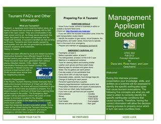
1. Tsunami FAQ’s and Other
Information
Preparing For A Tsunami Management
Applicant
EVERYONE SHOULD
What are Tsunamis? � Know if your house, school or business is within or
Tsunami, a Japanese word meaning harbor wave, is a outside a tsunami flood zone.
series of waves that can travel at speeds 400 to 500 Check out: http://tsunami.csc.noaa.gov
mph in the open ocean. They are unnoticeable in the
open ocean and by air. As these waves approach the
coast, the speed of the wave will decrease and the
� If you are within the tsunami evacuation zone, know the
safe transportation routes inland.
� Identify the location of gas valves, circuit breakers, fire
Brochure
height will increase. A tsunami’s landfall can last as long
extinguishers, and water valves. Know how to operate
as 8 hours. Tsunamis are most usually caused by
them in the event of an emergency.
earthquakes, but can also be generated by landslides,
� Prepare and maintain an emergency survival kit.
volcanic eruptions and meteorites.
History in Hawaii.
EMERGENCY SURVIVAL KIT
Hawaii has been affected by local and distant tsunamis. � Flashlights, at least 2 OTEC 602
Destructive tsunamis have affected Hawaii 8 times in � Battery-operated radios, at least 2 Fall 2012
the last century and resulted in 222 deaths statewide. � Fire extinguishers, at least 2 of the A-B-C type Concept Attainment
These tsunamis have been generated from various � Matches in a waterproof container by
places (Aleutian Islands, Chile, Japan, Russian � Tools for clearing debris and building shelter
� Leather work gloves and thick-soled shoes
Dana Ishii, Rose Hatori, and Leon
Kamchatka Peninsula and Hawaii County). The
volcanoes in Hawaii County can � Masking tape for windows and glass doors Geschwind
produce a local tsunami with a � Water, five (5) gallons per each person
20-60 minute wave arrival time � Five-day supply of non-perishable food Welcome!
for neighboring islands. � Camp stove with a 5-day fuel supply
� Disposable plates, utensils, food storage bags etc.
Hawaii’s Preparedness � Change of clothing for each person
During this interview process
If the Pacific Tsunami Warning Center forecasts that a � Personal hygiene/sanitary supplies presentation your knowledge, skills, and
destructive tsunami (minimum of 3 feet) will affect the � Sleeping bags/blankets/air mattresses and/or tent abilities as a scientist will be assessed to
Hawaiian Islands, the sirens will sound statewide to give � Prescription medications and copies of prescriptions identify the specific earthquake types
the public as much time as possible to prepare. For a � If you have an infant: baby food/supplies that cause tsunami evacuations. The
distant tsunami, a minimum of three hours warning time � If you have a pet, pet food and pet supplies
will be issued to the public. The Emergency Alert
following five concepts are what you will
� Extra batteries � Candles
System will be activated to inform the public of what � Money � First Aid Kit
need to attain to correctly identify the
danger is imminent. Located in the disaster � Ice chest � Insect spray specific earthquake conditions that
preparedness pages in the beginning of each county � Dust masks � Dust goggles cause tsunamis. Therefore, having the
phone book (online: http://tsunami.csc.noaa.gov) are � Shovel and other useful tools � Rain gear correct information will allow the decision
maps that designate tsunami evacuation areas. Some
roads will be closed during the Tsunami Warning time
making process to properly occur which
period to eliminate traffic congestion and insure in turn can save countless lives.
emergency vehicles have access to all areas.
KNOW YOUR FACTS BE PREPARED GOOD LUCK
2. References
- Peer Journal 1
Boulware, B. J., & Crow, M. (2008). Using the
Tsunami Evacuations
Concept Attainment Strategy to Enhance
Reading Comprehension. Reading Teacher,
61(6), 491-495.
Exemplar Non Exemplar
Retrieved from EBSCOhost.
Please add the keyword(s) that will help you distinguish between exemplars and non-exemplars
-Peer Journal 2
Nath, J. & Farran, H. (2001). Adapting Critical
Thinking Models to a Technological Approach. Location Location
In J. Price et al. (Eds.), Proceedings of Society
for Information Technology & Teacher
Education International Conference 2001 (pp.
1155-1158). Chesapeake, VA: AACE.
Retrieved from
http://www.editlib.org.eres.library.manoa.hawaii.
edu/p/16890.
Brochure Template: Plate Boundaries Plate Boundaries
Tyrrell, D. (2012). Lyme disease brochure
template. Retrieved from
https://docs.google.com/document/d/1lQfZiSQv
WkS60hIs0QDg0rnfCOC-
gPz8uhcx6sKVsSE/edit
Photos:
Magnitude Magnitude
National Oceanic Atmospheric Administration
Pacific Services Center. (2010).Tsunami map
viewer. Retrieved from
http://tsunami.csc.noaa.gov/
Google. (2012). Google Earth. Retrieved from
www.earth.google.com Depth Depth
General Tsunami Information and
Preparedness:
Red Cross. (2008). Tsunami. Retrieved from
http://www.hawaiiredcross.org/getprepared/tsun
ami.pdf
Inundated Zone Inundated Zone
Videos:
Discovery Education. (2012). Tsunami video.
Retrieved from www.discoveryeducation.com
Other:
Poll Everywhere. (2012). Poll everywhere.
Retrieved from www.polleverywhere.com