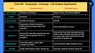
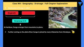
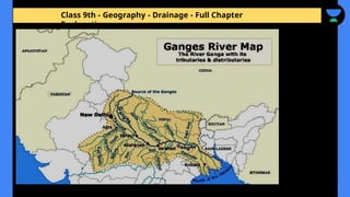
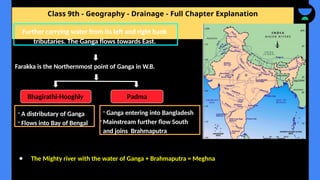
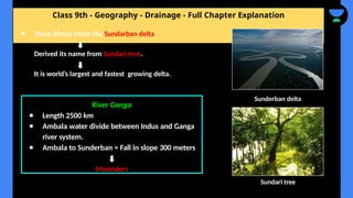
The document provides a comprehensive overview of drainage systems, focusing on the river systems of India, including Himalayan and peninsular rivers. It covers various drainage patterns, the importance of rivers and lakes, and issues related to river pollution. Key rivers discussed include the Indus, Ganga, Brahmaputra, and several peninsular rivers, detailing their characteristics, tributaries, and economic significance.
![Class 9th - Geography - Drainage - Full Chapter Explanation
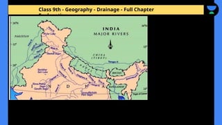
What we are going to study in this chapter?
❖ Drainage patterns
❖ Drainage systems in India
➢ The Himalayan Rivers
➢ The Peninsular Rivers
❖ The Himalayas Rivers: [The Indus, the Ganga, and the Brahmaputra]
❖ The Peninsular Rivers: [The Narmada, the Tapi, the Godavari, the Mahanadi, the Krishna
and the Kaveri]
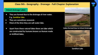
❖ Lakes
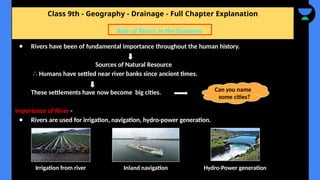
❖ Role of Rivers in the Economy
❖ River Pollution](https://image.slidesharecdn.com/drainagefullchapterexplanation-241216012041-848d7251/85/Drainage-full-chapter-explanation-pptx-4-320.jpg)

![Class 9th - Geography - Drainage - Full Chapter Explanation
● Rises in Tibet. Near lake Mansarovar.
Enters India from Ladakh
It is joined by the tributaries such as the Zaskar,
the Nurba, the Shyok and the Hunza.
Further flowing from the Baltistan and Gilgit,
Indus is joined by other tributaries such as the
Satluj, the Ravi, the Chenab and the Jhelum at
Mithankot in Pakistan.
Flowing Southwards Indus finally drains into
Arabian Sea.
River Indus
● Total length of 2900 km.
● Title over a third of Indus basin is
located in India.
Major part flows from Pakistan
Do you know? = Indus water treaty [1960]](https://image.slidesharecdn.com/drainagefullchapterexplanation-241216012041-848d7251/85/Drainage-full-chapter-explanation-pptx-11-320.jpg)
![Class 9th - Geography - Drainage - Full Chapter Explanation
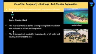
● These Rivers floods parts of the
Northern plains every year.
Causing damage to life and property
but at same time they enrich the soil
for agricultural use.
Do you know
Left Bank tributaries of Ganga Right bank tributaries of Ganga
● The Yamuna
● The Ghaghara
● The Gandak
● Kosi
[Rises from the glaciers in Himalayas]
● The Chambal
● The Betwa
● The Son
[Rises from Semi-arid part of Peninsular]
● They have a shorter courses and do not
carry much water.
The Namami Gange Programme](https://image.slidesharecdn.com/drainagefullchapterexplanation-241216012041-848d7251/85/Drainage-full-chapter-explanation-pptx-14-320.jpg)
![Class 9th - Geography - Drainage - Full Chapter Explanation
Rises in Tibet; East of Mansarovar lake
[Mansarovar lake = Water divide]
Slightly longer than the Indus and most of its course lies
outside India.
From Namcha Barwa, it takes ‘U’ turn and enters into
India in Arunachal Pradesh.
Here, it is known as Dihang, joined by other tributaries
such as Dibang, the Lohit etc.
Volume of water in river varies in Tibet and India.
Why?](https://image.slidesharecdn.com/drainagefullchapterexplanation-241216012041-848d7251/85/Drainage-full-chapter-explanation-pptx-20-320.jpg)
![Class 9th - Geography - Drainage - Full Chapter Explanation
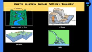
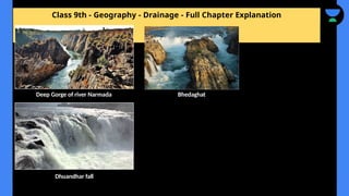
The Narmada Basin
Rises in the Amarkantak hills
● Flows west in Rift valley due to faulting
● River Narmada flows through deep gorge, forming
picturesque location. [The ‘Marble rocks’, near
Jabalpur, where the Narmada flows through a deep
gorge, and the ‘Dhuandhar falls]
● Most of the tributaries of Narmada are short and
joins at right angle. [Rectangular pattern]
● River flows in the parts of M.P and Gujarat.
Amarkantak point](https://image.slidesharecdn.com/drainagefullchapterexplanation-241216012041-848d7251/85/Drainage-full-chapter-explanation-pptx-25-320.jpg)
![Class 9th - Geography - Drainage - Full Chapter Explanation
● Rises in Satpura range in Betul district of
Madhya Pradesh.
● It also flows in Rift valley parallel to Narmada
but shorter in length.
● Flows through three states [M.P, Gujarat and
Maharashtra]
● Drains in Arabian sea.
Tapi Basin
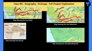
Are there only two west flowing rivers?
No, there are west flowing coastal rivers but
their length is short.
E.g. The Sabarmati, the Mahi, the
Bharathapuzha and the Periyar](https://image.slidesharecdn.com/drainagefullchapterexplanation-241216012041-848d7251/85/Drainage-full-chapter-explanation-pptx-27-320.jpg)
![Class 9th - Geography - Drainage - Full Chapter Explanation
❖ Rises in the Brahmagiri range of Western Ghats
[Karnataka]
Flows West and drains in Bay of Bengal in South
of Cuddalore in Tamil Nadu
● The total length of river is about 760 km.
● Its main tributaries are Amravati, Bhavani,
Hemavati and Kabini covering the parts of
Karnataka, Kerala and Tamil Nadu.
The Kaveri Basin](https://image.slidesharecdn.com/drainagefullchapterexplanation-241216012041-848d7251/85/Drainage-full-chapter-explanation-pptx-33-320.jpg)
![Class 9th - Geography - Drainage - Full Chapter Explanation
Lagoons
● Another important type of lakes.
● Mostly lagoons are salt water lakes [connected with sea]
● Lagoons are a shallow body of water separated from a larger
Body of water by barrier islands or reefs.
● Example of lagoon lakes are Chilika lake, the Pulicat lake and
Kolleru lake.
Chilika Lake Kolleru Lake](https://image.slidesharecdn.com/drainagefullchapterexplanation-241216012041-848d7251/85/Drainage-full-chapter-explanation-pptx-40-320.jpg)