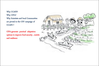
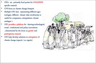
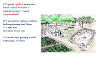
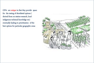
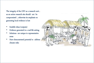
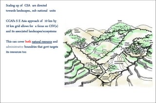
CSVs (Climate Smart Villages) are focal points for location-specific research on climate change adaptation options to improve food security, nutrition, and resilience. CSVs represent different agro-ecologies and climate risks, providing a platform to develop technological, social, institutional, and policy innovations through participatory research. CSVs help test and develop solutions to anticipate climate change impacts at a scale relevant to communities. They promote local adaptation and capacity building by engaging researchers, farmers, and stakeholders in a defined geographic area. The integrity of the CSV as a research unit should not be compromised, otherwise its emphasis on generating local evidence is lost.
How water storage for energy and food production affects the Zambezi River’s ...DAFNE project
Presentation held at the General Assembly 2019 of the European Geosciences Union (EGU) is held at the Austria Center Vienna (ACV) in Vienna, Austria, from 7–12 April 2019
Presentation by Julian Ramirez-Villegas.
CCAFS workshop titled "Using Climate Scenarios and Analogues for Designing Adaptation Strategies in Agriculture," 19-23 September in Kathmandu, Nepal.
Presented by Kindie at the International Forum on Water and Food (IFWF), South Africa, 14-17 November 2011.
The International Forum on Water and Food (IFWF) is the premier gathering of water and food scientists working on improving water management for agricultural production in developing countries.
Key territories of the Mesoamerican Agroenvironmental Program (MAP): concepts...CIFOR-ICRAF
The Mesoamerican Agroenvironmental Program (MAP) is a regional development programme that incorporates a lot of applied research. In this presentation, experiences with MAP that are relevant to planning for CRP6 Sentinel Landscapes are outlined.
This presentation formed part of the CRP6 Sentinel Landscape planning workshop held on 30 September – 1 October 2011 at CIFOR’s headquarters in Bogor, Indonesia. Further information on CRP6 and Sentinel Landscapes can be accessed from http://www.cifor.org/crp6/ and http://www.cifor.org/fileadmin/subsites/crp/CRP6-Sentinel-Landscape-workplan_2011-2014.pdf respectively.
Tools for spatial conservation prioritizationjlehtoma
Spatial conservation prioritization is about identifying priority areas for biodiversity, as well as the allocation and scheduling of alternative conservation actions to inform decision-making. In other words, spatial conservation prioritization tries to answer the question of where, when, and how we act to efficiently meet conservation goals. Efficiency is an important concept, as possible conservation actions are always limited by available resources. Spatial conservation prioritization can be informative for many different types of conservation action, such as selecting locations most suitable for extending protected area network, targeting restoration and management, or designing broad scale green infrastructure.
The term “quantitative” refers to prioritization based on quantitative and spatially explicit data that describes the extent and occurrence of biodiversity features (e.g. species and habitats) and other relevant information (e.g. costs and threats). A prioritization algorithm then does the actual prioritization by ordering the planning units used according to some explicit formulation and the results are usually presented in the form of maps that describe the spatial distribution of priorities over the area of interest. Tools aimed at quantitative spatial conservation prioritization have multiple distinct advantages over non-quantitative approaches. They are able to account for the occurrence of biodiversity over potentially very broad geographical areas. For example, when working with species on local level, it is important to account for the occurrence of that species elsewhere. When designing new protected areas, it is similarly important to know what is already protected. Ecological connectivity is yet another factor that is not easy to account for in conventional planning. Expert-based and quantitative approaches are not, however, mutually exclusive. Expert input is always needed to make use of quantitative spatial conservation planning tools.
In this short seminar, we will cover the basics and some available tools for spatial conservation prioritization. We will also go through the most typical stages of a spatial conservation prioritization project using a specific tool, Zonation, as an example. Zonation is a tool for balancing the requirements of many features, such as biodiversity or ecosystem services features, simultaneously in ecologically informed land use planning. In addition to conservation prioritization, Zonation is suited also for general land use planning and resource allocation. We will go through multiple real-life example projects in which Zonation has been used as a decision-support tool. We will also discuss different sources of data needed, as well as typical resources needed to run a prioritization project using Zonation. This seminar should give the attendees a basic understanding what spatial conservation prioritization is useful for.
Talk on sustainable consumption and production in the context of the climate crisis . Part of the lecture on Global climate change given at Webster University , Vienna.
What makes impact research challenging? What have been done so far? Results from CGIAR research - Natalia Estrada Carmona. Measuring the Impact of Integrated Systems Research (September 27, 2021 – September 30, 2021). Three-day virtual workshop co hosted by the CGIAR Research Programs on Water Land and Ecosystems (WLE); Forests, Trees and Agroforestry (FTA); Policies, Institutions, and Markets (PIM); and SPIA, the Standing Panel on Impact Assessment of the CGIAR. The workshop took stock of existing and new methodological developments of monitoring, evaluation and impact assessment work, and discussed which are suitable to evaluate and assess complex, integrated systems research.
A presentation given at the WLE Ganges Focal Region writeshop in 2014 on the Ecosystem Services and Resilience Framework (ESR). Put together and presented by Sarah Jones of Bioversity International.
Urbinsight is a next-generation data analysis platform designed for participatory mapping and planning processes. Its goal is to provide engaged cities and citizens with the necessary tools and technology to affect the resiliency and sustainability of their cities and settlements in a positive way. Evolved from earlier mapping methods that we pioneered in the San Francisco Bay Area in the 2000s, the project was first launched as the Ecocitizen World Map in 2014 and has since morphed into the much larger Urbinsight platform.
The Accelerating Impact of CGIAR Climate Research for Africa (AICCRA) project works to deliver a climate-smart African future driven by science and innovation in agriculture.
AICCRA does this by enhancing access to climate information services and climate-smart agricultural technology to millions of smallholder farmers in Africa.
With better access to climate technology and advisory services—linked to information about effective response measures—farmers can better anticipate climate-related events and take preventative action that help communities better safeguard their livelihoods and the environment.
AICCRA is supported by a grant from the International Development Association (IDA) of the World Bank, which is used to enhance research and capacity-building activities by the CGIAR centers and initiatives as well as their partners in Africa.
About IDA: IDA helps the world’s poorest countries by providing grants and low to zero-interest loans for projects and programmes that boost economic growth, reduce poverty, and improve poor people’s lives.
IDA is one of the largest sources of assistance for the world’s 76 poorest countries, 39 of which are in Africa.
Annual IDA commitments have averaged about $21 billion over circa 2017-2020, with approximately 61 percent going to Africa.
This presentation was given on 27 October 2021 by Mengpin Ge, Global Climate Program Associate at WRI, during the webinar "Achieving NDC Ambition in Agriculture" organized by CCAFS, FAO and WRI.
Find the recording and more information here: https://bit.ly/AchievingNDCs
More Related Content
Similar to CSVs: Purpose, focus, scale and more...
Presented by Kindie at the International Forum on Water and Food (IFWF), South Africa, 14-17 November 2011.
The International Forum on Water and Food (IFWF) is the premier gathering of water and food scientists working on improving water management for agricultural production in developing countries.
Key territories of the Mesoamerican Agroenvironmental Program (MAP): concepts...CIFOR-ICRAF
The Mesoamerican Agroenvironmental Program (MAP) is a regional development programme that incorporates a lot of applied research. In this presentation, experiences with MAP that are relevant to planning for CRP6 Sentinel Landscapes are outlined.
This presentation formed part of the CRP6 Sentinel Landscape planning workshop held on 30 September – 1 October 2011 at CIFOR’s headquarters in Bogor, Indonesia. Further information on CRP6 and Sentinel Landscapes can be accessed from http://www.cifor.org/crp6/ and http://www.cifor.org/fileadmin/subsites/crp/CRP6-Sentinel-Landscape-workplan_2011-2014.pdf respectively.
Tools for spatial conservation prioritizationjlehtoma
Spatial conservation prioritization is about identifying priority areas for biodiversity, as well as the allocation and scheduling of alternative conservation actions to inform decision-making. In other words, spatial conservation prioritization tries to answer the question of where, when, and how we act to efficiently meet conservation goals. Efficiency is an important concept, as possible conservation actions are always limited by available resources. Spatial conservation prioritization can be informative for many different types of conservation action, such as selecting locations most suitable for extending protected area network, targeting restoration and management, or designing broad scale green infrastructure.
The term “quantitative” refers to prioritization based on quantitative and spatially explicit data that describes the extent and occurrence of biodiversity features (e.g. species and habitats) and other relevant information (e.g. costs and threats). A prioritization algorithm then does the actual prioritization by ordering the planning units used according to some explicit formulation and the results are usually presented in the form of maps that describe the spatial distribution of priorities over the area of interest. Tools aimed at quantitative spatial conservation prioritization have multiple distinct advantages over non-quantitative approaches. They are able to account for the occurrence of biodiversity over potentially very broad geographical areas. For example, when working with species on local level, it is important to account for the occurrence of that species elsewhere. When designing new protected areas, it is similarly important to know what is already protected. Ecological connectivity is yet another factor that is not easy to account for in conventional planning. Expert-based and quantitative approaches are not, however, mutually exclusive. Expert input is always needed to make use of quantitative spatial conservation planning tools.
In this short seminar, we will cover the basics and some available tools for spatial conservation prioritization. We will also go through the most typical stages of a spatial conservation prioritization project using a specific tool, Zonation, as an example. Zonation is a tool for balancing the requirements of many features, such as biodiversity or ecosystem services features, simultaneously in ecologically informed land use planning. In addition to conservation prioritization, Zonation is suited also for general land use planning and resource allocation. We will go through multiple real-life example projects in which Zonation has been used as a decision-support tool. We will also discuss different sources of data needed, as well as typical resources needed to run a prioritization project using Zonation. This seminar should give the attendees a basic understanding what spatial conservation prioritization is useful for.
Talk on sustainable consumption and production in the context of the climate crisis . Part of the lecture on Global climate change given at Webster University , Vienna.
What makes impact research challenging? What have been done so far? Results from CGIAR research - Natalia Estrada Carmona. Measuring the Impact of Integrated Systems Research (September 27, 2021 – September 30, 2021). Three-day virtual workshop co hosted by the CGIAR Research Programs on Water Land and Ecosystems (WLE); Forests, Trees and Agroforestry (FTA); Policies, Institutions, and Markets (PIM); and SPIA, the Standing Panel on Impact Assessment of the CGIAR. The workshop took stock of existing and new methodological developments of monitoring, evaluation and impact assessment work, and discussed which are suitable to evaluate and assess complex, integrated systems research.
A presentation given at the WLE Ganges Focal Region writeshop in 2014 on the Ecosystem Services and Resilience Framework (ESR). Put together and presented by Sarah Jones of Bioversity International.
Urbinsight is a next-generation data analysis platform designed for participatory mapping and planning processes. Its goal is to provide engaged cities and citizens with the necessary tools and technology to affect the resiliency and sustainability of their cities and settlements in a positive way. Evolved from earlier mapping methods that we pioneered in the San Francisco Bay Area in the 2000s, the project was first launched as the Ecocitizen World Map in 2014 and has since morphed into the much larger Urbinsight platform.
The Accelerating Impact of CGIAR Climate Research for Africa (AICCRA) project works to deliver a climate-smart African future driven by science and innovation in agriculture.
AICCRA does this by enhancing access to climate information services and climate-smart agricultural technology to millions of smallholder farmers in Africa.
With better access to climate technology and advisory services—linked to information about effective response measures—farmers can better anticipate climate-related events and take preventative action that help communities better safeguard their livelihoods and the environment.
AICCRA is supported by a grant from the International Development Association (IDA) of the World Bank, which is used to enhance research and capacity-building activities by the CGIAR centers and initiatives as well as their partners in Africa.
About IDA: IDA helps the world’s poorest countries by providing grants and low to zero-interest loans for projects and programmes that boost economic growth, reduce poverty, and improve poor people’s lives.
IDA is one of the largest sources of assistance for the world’s 76 poorest countries, 39 of which are in Africa.
Annual IDA commitments have averaged about $21 billion over circa 2017-2020, with approximately 61 percent going to Africa.
This presentation was given on 27 October 2021 by Mengpin Ge, Global Climate Program Associate at WRI, during the webinar "Achieving NDC Ambition in Agriculture" organized by CCAFS, FAO and WRI.
Find the recording and more information here: https://bit.ly/AchievingNDCs
This presentation was given on 27 October 2021 by Sabrina Rose, Policy Consultant at CCAFS, during the webinar "Achieving NDC Ambition in Agriculture" organized by CCAFS, FAO and WRI.
Find the recording and more information here: https://bit.ly/AchievingNDCs
This presentation was given on 27 October 2021 by Krystal Crumpler, Climate Change and Agricultural Specialist at FAO, during the webinar "Achieving NDC Ambition in Agriculture" organized by CCAFS, FAO and WRI.
Find the recording and more information here: https://bit.ly/AchievingNDCs
This presentation was meant to be included in the 2021 CLIFF-GRADS Welcome Webinar and presented by Ciniro Costa Jr. (CCAFS).
The webinar recording can be found here: https://youtu.be/UoX6aoC4fhQ
The multilevel CSA monitoring set of standard core uptake and outcome indicators + expanded indicators linked to a rapid and reliable ICT based data collection instrument to systematically
assess and monitor:
- CSA Adoption/ Access to CIS
- CSA effects on food security and livelihoods household level)
- CSA effects on farm performance
Presented by Harsh Rajpal, Code Partners Pte. Ltd., on 30 June 2021 at the Asian Development Bank (ADB) Webinar on Sustainable Protein Case Study: Outputs and Synthesis of Results.
Presented by Ciniro Costa Jr., CCAFS, on 28 June 2021 at the Asian Development Bank (ADB) Webinar on Sustainable Protein Case Study: Outputs and Synthesis of Results.
Presented by Marion de Vries, Wageningen Livestock Research at Wageningen University, on 28 June 2021 at the Asian Development Bank (ADB) Webinar on Sustainable Protein Case Study: Outputs and Synthesis of Results.
Presented by Issac Emery, Informed Sustainability Consulting, on 29 June 2021 at the second day of the Asian Development Bank (ADB) Webinar on Sustainable Protein Case Study: Outputs and Synthesis of Results.
Presented by Hongmin Dong and Sha Wei, Chinese Academy of Agricultural Sciences (CAAS), on 28 June 2021 at the Asian Development Bank (ADB) Webinar on Sustainable Protein Case Study: Outputs and Synthesis of Results.
Presented by Lini Wollenberg, CCAFS, on 28 June 2021 at the Asian Development Bank (ADB) Webinar on Sustainable Protein Case Study: Outputs and Synthesis of Results.
Presentation by Han Soethoudt, Jan Broeze, and Heike Axmann of Wageningen University & Resaearch (WUR).
WUR and Olam Rice Nigeria conducted a controlled experiment in Nigeria in which mechanized rice harvesting and threshing were introduced on smallholder farms. The result of the study shows that mechanization considerably reduces losses, has a positive impact on farmers’ income, and the climate.
Learn more: https://www.wur.nl/en/news-wur/show-day/Mechanization-helps-Nigerian-farms-reduce-food-loss-and-increase-income.htm
Presentation on the rapid evidence review findings and key take away messages.
Current evidence for biodiversity and agriculture to achieve and bridging gaps in research and investment to reach multiple global goals.
This presentation was given at an internal workshop in April 2020 and was presented by Le Hoang Anh, Hoang Thi Thien Huong, Le Thi Thanh Huyen, and Nguyen Thi Lien Huong.
Model Attribute Check Company Auto PropertyCeline George
In Odoo, the multi-company feature allows you to manage multiple companies within a single Odoo database instance. Each company can have its own configurations while still sharing common resources such as products, customers, and suppliers.
Unit 8 - Information and Communication Technology (Paper I).pdfThiyagu K
This slides describes the basic concepts of ICT, basics of Email, Emerging Technology and Digital Initiatives in Education. This presentations aligns with the UGC Paper I syllabus.
Welcome to TechSoup New Member Orientation and Q&A (May 2024).pdfTechSoup
In this webinar you will learn how your organization can access TechSoup's wide variety of product discount and donation programs. From hardware to software, we'll give you a tour of the tools available to help your nonprofit with productivity, collaboration, financial management, donor tracking, security, and more.
Students, digital devices and success - Andreas Schleicher - 27 May 2024..pptxEduSkills OECD
Andreas Schleicher presents at the OECD webinar ‘Digital devices in schools: detrimental distraction or secret to success?’ on 27 May 2024. The presentation was based on findings from PISA 2022 results and the webinar helped launch the PISA in Focus ‘Managing screen time: How to protect and equip students against distraction’ https://www.oecd-ilibrary.org/education/managing-screen-time_7c225af4-en and the OECD Education Policy Perspective ‘Students, digital devices and success’ can be found here - https://oe.cd/il/5yV
Synthetic Fiber Construction in lab .pptxPavel ( NSTU)
Synthetic fiber production is a fascinating and complex field that blends chemistry, engineering, and environmental science. By understanding these aspects, students can gain a comprehensive view of synthetic fiber production, its impact on society and the environment, and the potential for future innovations. Synthetic fibers play a crucial role in modern society, impacting various aspects of daily life, industry, and the environment. ynthetic fibers are integral to modern life, offering a range of benefits from cost-effectiveness and versatility to innovative applications and performance characteristics. While they pose environmental challenges, ongoing research and development aim to create more sustainable and eco-friendly alternatives. Understanding the importance of synthetic fibers helps in appreciating their role in the economy, industry, and daily life, while also emphasizing the need for sustainable practices and innovation.
The Art Pastor's Guide to Sabbath | Steve ThomasonSteve Thomason
What is the purpose of the Sabbath Law in the Torah. It is interesting to compare how the context of the law shifts from Exodus to Deuteronomy. Who gets to rest, and why?
This is a presentation by Dada Robert in a Your Skill Boost masterclass organised by the Excellence Foundation for South Sudan (EFSS) on Saturday, the 25th and Sunday, the 26th of May 2024.
He discussed the concept of quality improvement, emphasizing its applicability to various aspects of life, including personal, project, and program improvements. He defined quality as doing the right thing at the right time in the right way to achieve the best possible results and discussed the concept of the "gap" between what we know and what we do, and how this gap represents the areas we need to improve. He explained the scientific approach to quality improvement, which involves systematic performance analysis, testing and learning, and implementing change ideas. He also highlighted the importance of client focus and a team approach to quality improvement.
The Roman Empire A Historical Colossus.pdfkaushalkr1407
The Roman Empire, a vast and enduring power, stands as one of history's most remarkable civilizations, leaving an indelible imprint on the world. It emerged from the Roman Republic, transitioning into an imperial powerhouse under the leadership of Augustus Caesar in 27 BCE. This transformation marked the beginning of an era defined by unprecedented territorial expansion, architectural marvels, and profound cultural influence.
The empire's roots lie in the city of Rome, founded, according to legend, by Romulus in 753 BCE. Over centuries, Rome evolved from a small settlement to a formidable republic, characterized by a complex political system with elected officials and checks on power. However, internal strife, class conflicts, and military ambitions paved the way for the end of the Republic. Julius Caesar’s dictatorship and subsequent assassination in 44 BCE created a power vacuum, leading to a civil war. Octavian, later Augustus, emerged victorious, heralding the Roman Empire’s birth.
Under Augustus, the empire experienced the Pax Romana, a 200-year period of relative peace and stability. Augustus reformed the military, established efficient administrative systems, and initiated grand construction projects. The empire's borders expanded, encompassing territories from Britain to Egypt and from Spain to the Euphrates. Roman legions, renowned for their discipline and engineering prowess, secured and maintained these vast territories, building roads, fortifications, and cities that facilitated control and integration.
The Roman Empire’s society was hierarchical, with a rigid class system. At the top were the patricians, wealthy elites who held significant political power. Below them were the plebeians, free citizens with limited political influence, and the vast numbers of slaves who formed the backbone of the economy. The family unit was central, governed by the paterfamilias, the male head who held absolute authority.
Culturally, the Romans were eclectic, absorbing and adapting elements from the civilizations they encountered, particularly the Greeks. Roman art, literature, and philosophy reflected this synthesis, creating a rich cultural tapestry. Latin, the Roman language, became the lingua franca of the Western world, influencing numerous modern languages.
Roman architecture and engineering achievements were monumental. They perfected the arch, vault, and dome, constructing enduring structures like the Colosseum, Pantheon, and aqueducts. These engineering marvels not only showcased Roman ingenuity but also served practical purposes, from public entertainment to water supply.
How to Split Bills in the Odoo 17 POS ModuleCeline George
Bills have a main role in point of sale procedure. It will help to track sales, handling payments and giving receipts to customers. Bill splitting also has an important role in POS. For example, If some friends come together for dinner and if they want to divide the bill then it is possible by POS bill splitting. This slide will show how to split bills in odoo 17 POS.
2. Why CCAFS?
Why CSVs?
Why Scientists and local Communities
are pivotal in the CSV campaign of
CCAFS ?
CSVs generate practical adaptation
options to improve food security , nutrition
and resilience
3. • CSVs are primarily focal points for LOCATION
specific research
• CVS focus on climate change hotspots
• Multiple CSV sites representing different agro
ecologies, different climate risks etc(diversity is
useful for comparison, extrapolation, climate
analogue )
• CSV provides a platform for deriving technological,
social , institutional and policy innovations
..characterized by the focus on gender and
participatory research
• CSV help develop solutions in anticipation of
climate change impacts ( no regrets)
4. CSVs within small landscapes ? ?
Climate ,Environment , Ecosytem
elements interact with farms and local
communities ( a small landscape or
micro water shed orientation)
Natural resource boundries are
important due to ecosystem influences
on climate, adaptation ,resilience building objectives
Sometimes collective action on wider
scale is implied in
successful adaptation( eg no burning of
rice straw)
5. CSVs are “lighthouses” to show where
communities test and develop and adopt on
a scale that matters
( otherwise we are back to doing on-farm
research)
CSV provide platforms for multi stakeholder
participation-integrating mechanisms,
collaborative work in targeted , delineated
geographic –agro ecological areas-(
“territories ” or “small landscapes”
6. CSVs provide a platform for researchers,
farmers and local stakeholders to
engage in participatory research
(community based)
CSVs promote local adaptation and builds
local adaptation capacities ( this sets
CSVs apart from
conventional on farm trials
CSVs are also about generating R and D
methodological innovations
7. CSVs are unique in that they provide space
for the testing of shortlisted options (
derived from on station-research, local
indigenous technical knowledge etc)
eventually leading to prioritization of the
best options for particular geographic areas
8. The integrity of the CSV as a research unit ,
as an action research site should not be
compromised …otherwise its emphasis on
generating local evidence is lost
• Scalable ideas (outputs)
• Evidence generated in a real-life setting
• Solutions are unique to representative
areas
• Have demonstrated potential to address
climate risks
9. The reality : CSVs are also being used as
conduits for scaling out CSA (even without a
research agenda)
Expansion is inevitable
(Haryana govt from 28 to 500 CSV
scenario) ..So view CSVs )
as scaling out modalities as well…
Delivering outcomes on scale
BUT Important that CSV proponent
clarify the role and purpose of
doing CSVs and their scope
10. Scaling up of CSA are directed
towards landscapes., sub national units
CCAFs S E Asia approach of 10 km by
10 km grid allows for a focus on CSV(s)
and its associated landscapes/ecosystems
This can cover both natural resource and
administrative boundries that govt targets
its resources too
11. The question of scale must be understood in
the context of what is driving the need for
CSV
12. REMINDER 1
Adaptation research characterized by CSVs
helps build and nuture local capacities at
different levels, to continue to innovate,
experiment, and adapt…often incremental
adaptation is implied
Communities which have had successful
community level adaptation management
experience are likely to adapt better to
future change
13. REMINDER 2
In a CSV, ultimately we need to ask
ourselves whose needs are being
addressed?
Reduced poverty, improved
livelihoods, better nutrition (and
more research papers as side benefit)