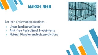
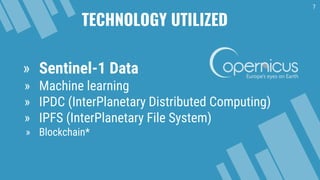
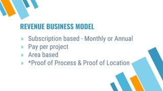
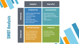
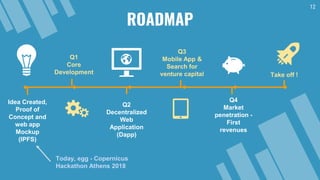
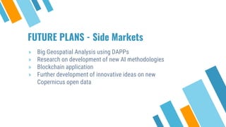
COPERNIONS
Copernicus Innovative Solutions
1
2
The Team
Vatousios
Antonis
Financials,
Product
manager
(R)
Kalaitzakis
Nektarios
Environmental,
GIS and
Statistics
Expert
(R)
Fratti
Panagiota
Alexandra
Business
Development,
Strategic
Market
Analysis
Karles
Panagiotis
Software (Dapp)
Developer,
Technology
Management
(R, Python)
Anastasakis
Konstantinos
Geomatics
Engineer
Innovation
Management
(C++, Python)
The Team
THE CHALLENGE
For land deformation solutions
» Urban land surveillance
» Risk-free Agricultural Investments
» Natural Disaster analysis/predictions
MARKET NEED
MARKET ANALYSIS
» A growing market due to climate change and
human economic activity
» In global scale displacements are causing
devastating economical damage
» Strong interest by venture capital in the area of
water investment
THE SOLUTION
6
Automated land deformation innovative
solutions through Copernicus data
TECHNOLOGY UTILIZED
7
» Sentinel-1 Data
» Machine learning
» IPDC (InterPlanetary Distributed Computing)
» IPFS (InterPlanetary File System)
» Blockchain*
THE PRODUCT
Simple and easy to use Mobile
and Web App.
8
MARKET ENTRY - DISTRIBUTION
CHANNELS & KEY PARTNERS
» Insurance companies
» Farmers
» Landowners
» Cooperatives
» Government/Local authority
» Organisations
» Universities
» Science institutions
» Construction companies
REVENUE BUSINESS MODEL
» Subscription based - Monthly or Annual
» Pay per project
» Area based
» *Proof of Process & Proof of Location
SWOTAnalysis STRENGTHS
-Cutting edge technology
-Free access to
Copernicus data
-Scientific
interdisciplinarity
-Automated solutions
-Near real time*
WEAKNESSES
-Restricted market
-Slow natural process
-Dependence on external
data
-Stochasticity
OPPORTUNITIES
-E.C. prioritization for
space research and
disaster mediation
-Accelerating water
resources demand
-Climate change
THREATS
-Limited funding
-Development time
-Limited technology
penetration
12
ROADMAP
Idea Created,
Proof of
Concept and
web app
Mockup
(IPFS)
Today, egg - Copernicus
Hackathon Athens 2018
Q1
Core
Development
Q2
Decentralized
Web
Application
(Dapp)
Q3
Mobile App &
Search for
venture capital
Q4
Market
penetration -
First
revenues
Take off !
FUTURE PLANS - Side Markets
» Big Geospatial Analysis using DAPPs
» Research on development of new AI methodologies
» Blockchain application
» Further development of innovative ideas on new
Copernicus open data
Indicative bibliography
14
» Chaussard, E., Amelung, F., Abidin, H., & Hong, S. H. (2013). Sinking cities in Indonesia: ALOS PALSAR
detects rapid subsidence due to groundwater and gas extraction. Remote Sensing of Environment, 128,
150-161.
» Galloway, D. L., Hudnut, K. W., Ingebritsen, S. E., Phillips, S. P., Peltzer, G., Rogez, F., & Rosen, P. A.
(1998). Detection of aquifer system compaction and land subsidence using interferometric synthetic
aperture radar, Antelope Valley, Mojave Desert, California. Water Resources Research, 34(10), 2573-
2585.
» Land Subsidence mapping with Sentinel-1 - HAZA03
» Geometric Accuracy of Sentinel-1A and 1B Derived from SAR Raw Data with GPS Surveyed Corner
Reflector Positions
Contacts
You can find as at
our Official Website
(http://copernions.hashbase.io)
15

Copernicus hackathon

  • 1.
  • 2.
  • 3.
  • 4.
    For land deformationsolutions » Urban land surveillance » Risk-free Agricultural Investments » Natural Disaster analysis/predictions MARKET NEED
  • 5.
    MARKET ANALYSIS » Agrowing market due to climate change and human economic activity » In global scale displacements are causing devastating economical damage » Strong interest by venture capital in the area of water investment
  • 6.
    THE SOLUTION 6 Automated landdeformation innovative solutions through Copernicus data
  • 7.
    TECHNOLOGY UTILIZED 7 » Sentinel-1Data » Machine learning » IPDC (InterPlanetary Distributed Computing) » IPFS (InterPlanetary File System) » Blockchain*
  • 8.
    THE PRODUCT Simple andeasy to use Mobile and Web App. 8
  • 9.
    MARKET ENTRY -DISTRIBUTION CHANNELS & KEY PARTNERS » Insurance companies » Farmers » Landowners » Cooperatives » Government/Local authority » Organisations » Universities » Science institutions » Construction companies
  • 10.
    REVENUE BUSINESS MODEL »Subscription based - Monthly or Annual » Pay per project » Area based » *Proof of Process & Proof of Location
  • 11.
    SWOTAnalysis STRENGTHS -Cutting edgetechnology -Free access to Copernicus data -Scientific interdisciplinarity -Automated solutions -Near real time* WEAKNESSES -Restricted market -Slow natural process -Dependence on external data -Stochasticity OPPORTUNITIES -E.C. prioritization for space research and disaster mediation -Accelerating water resources demand -Climate change THREATS -Limited funding -Development time -Limited technology penetration
  • 12.
    12 ROADMAP Idea Created, Proof of Conceptand web app Mockup (IPFS) Today, egg - Copernicus Hackathon Athens 2018 Q1 Core Development Q2 Decentralized Web Application (Dapp) Q3 Mobile App & Search for venture capital Q4 Market penetration - First revenues Take off !
  • 13.
    FUTURE PLANS -Side Markets » Big Geospatial Analysis using DAPPs » Research on development of new AI methodologies » Blockchain application » Further development of innovative ideas on new Copernicus open data
  • 14.
    Indicative bibliography 14 » Chaussard,E., Amelung, F., Abidin, H., & Hong, S. H. (2013). Sinking cities in Indonesia: ALOS PALSAR detects rapid subsidence due to groundwater and gas extraction. Remote Sensing of Environment, 128, 150-161. » Galloway, D. L., Hudnut, K. W., Ingebritsen, S. E., Phillips, S. P., Peltzer, G., Rogez, F., & Rosen, P. A. (1998). Detection of aquifer system compaction and land subsidence using interferometric synthetic aperture radar, Antelope Valley, Mojave Desert, California. Water Resources Research, 34(10), 2573- 2585. » Land Subsidence mapping with Sentinel-1 - HAZA03 » Geometric Accuracy of Sentinel-1A and 1B Derived from SAR Raw Data with GPS Surveyed Corner Reflector Positions
  • 15.
    Contacts You can findas at our Official Website (http://copernions.hashbase.io) 15

Editor's Notes

  • #4 Urban land surveillance = disasters by flud in an urban area and by paving streams
  • #5 Urban land surveillance = disasters by flud in an urban area and by paving streams