COBWEB: helping to map vegetation - work with Aberystwyth University - Crona ...COBWEB Project
Hodges, C. 2014. COBWEB: helping to map vegetation - work with Aberystwyth University. Presentation as part of the COBWEB Workshop, 22nd May 2014, y Plas, Dyfi, UK.
COBWEB: helping to map vegetation - work with Aberystwyth University - Crona ...COBWEB Project
Hodges, C. 2014. COBWEB: helping to map vegetation - work with Aberystwyth University. Presentation as part of the COBWEB Workshop, 22nd May 2014, y Plas, Dyfi, UK.
Stephan Krabsen of European Green Cities introduces the work towards zero energy communities being promoted by the RINNO project, a Horizon 2020 funded programme, at the SDG4B virtual event hosted by DCU Business School and the Irish Institute of Digital Business.
Stephan Krabsen of European Green Cities introduces the work towards zero energy communities being promoted by the RINNO project, a Horizon 2020 funded programme, at the SDG4B virtual event hosted by DCU Business School and the Irish Institute of Digital Business.
UNESCO and GIAHS Beyond designation schemes, working together for a sustainab...ExternalEvents
http://www.fao.org/giahs/en/
This presentation was presented during the Joint Meeting of Steering and Scientific Commitee that took place at FAO headquarters 28-29 April 2015. The presentation was made by Mr. Philippe Pypaert, UNESCO
The GEOLAND Project was presented at the United Nations as part of the twelfth session of the United Nations Committee of Experts on Global Geospatial Information Management (UN-GGIM). The meeting was held from 3 – 5 August 2022.
GEOLAND deals with the concepts, data, tools and technologies concerning the monitoring of landscapes based on the rules of the European Landscape Convention (ELC). As a result the project aims to inform and advise students and their professors concerning the policy implications of undertaking landscape monitoring and assessment. GEOLAND will help students and professors to comprehend the problems that arise from heterogeneous applications of ELC and suggest possible solutions to these issues.
The GEOLAND project also seeks to reinforce European Policy in landscape conservation as well as national and local actions regarding the implementation of the European Landscape Convention.
It will seek to provide essential recommendations for policy makers and maintain a dialogue with relevant stakeholders, open for future development. The methodology employed is eventually expected to constitute a road map for relevant studies not only in Europe but also worldwide.
UN-GGIM is the relevant inter-governmental body on geospatial information in the United Nations, UN-GGIM reports on all matters relating to geography, geospatial information and related topics to the United Nations Economic and Social Council (ECOSOC).
Outcome of the Consultation on establishing an European Ocean Observing Syste...EMODnet
Glenn Nolan, EuroGOOS, presents the outcomes of the consultation on establishing a European Ocean Observing System at the EMODnet stakeholder conference, 14-15 February 2017, Brussels.
Similar to Cn tu12 00_alt_desire_project_summary_verzandvoort (11)
Macroeconomics- Movie Location
This will be used as part of your Personal Professional Portfolio once graded.
Objective:
Prepare a presentation or a paper using research, basic comparative analysis, data organization and application of economic information. You will make an informed assessment of an economic climate outside of the United States to accomplish an entertainment industry objective.
2024.06.01 Introducing a competency framework for languag learning materials ...Sandy Millin
http://sandymillin.wordpress.com/iateflwebinar2024
Published classroom materials form the basis of syllabuses, drive teacher professional development, and have a potentially huge influence on learners, teachers and education systems. All teachers also create their own materials, whether a few sentences on a blackboard, a highly-structured fully-realised online course, or anything in between. Despite this, the knowledge and skills needed to create effective language learning materials are rarely part of teacher training, and are mostly learnt by trial and error.
Knowledge and skills frameworks, generally called competency frameworks, for ELT teachers, trainers and managers have existed for a few years now. However, until I created one for my MA dissertation, there wasn’t one drawing together what we need to know and do to be able to effectively produce language learning materials.
This webinar will introduce you to my framework, highlighting the key competencies I identified from my research. It will also show how anybody involved in language teaching (any language, not just English!), teacher training, managing schools or developing language learning materials can benefit from using the framework.
How to Make a Field invisible in Odoo 17Celine George
It is possible to hide or invisible some fields in odoo. Commonly using “invisible” attribute in the field definition to invisible the fields. This slide will show how to make a field invisible in odoo 17.
Synthetic Fiber Construction in lab .pptxPavel ( NSTU)
Synthetic fiber production is a fascinating and complex field that blends chemistry, engineering, and environmental science. By understanding these aspects, students can gain a comprehensive view of synthetic fiber production, its impact on society and the environment, and the potential for future innovations. Synthetic fibers play a crucial role in modern society, impacting various aspects of daily life, industry, and the environment. ynthetic fibers are integral to modern life, offering a range of benefits from cost-effectiveness and versatility to innovative applications and performance characteristics. While they pose environmental challenges, ongoing research and development aim to create more sustainable and eco-friendly alternatives. Understanding the importance of synthetic fibers helps in appreciating their role in the economy, industry, and daily life, while also emphasizing the need for sustainable practices and innovation.
The French Revolution, which began in 1789, was a period of radical social and political upheaval in France. It marked the decline of absolute monarchies, the rise of secular and democratic republics, and the eventual rise of Napoleon Bonaparte. This revolutionary period is crucial in understanding the transition from feudalism to modernity in Europe.
For more information, visit-www.vavaclasses.com
Instructions for Submissions thorugh G- Classroom.pptxJheel Barad
This presentation provides a briefing on how to upload submissions and documents in Google Classroom. It was prepared as part of an orientation for new Sainik School in-service teacher trainees. As a training officer, my goal is to ensure that you are comfortable and proficient with this essential tool for managing assignments and fostering student engagement.
Welcome to TechSoup New Member Orientation and Q&A (May 2024).pdfTechSoup
In this webinar you will learn how your organization can access TechSoup's wide variety of product discount and donation programs. From hardware to software, we'll give you a tour of the tools available to help your nonprofit with productivity, collaboration, financial management, donor tracking, security, and more.
The Roman Empire A Historical Colossus.pdfkaushalkr1407
The Roman Empire, a vast and enduring power, stands as one of history's most remarkable civilizations, leaving an indelible imprint on the world. It emerged from the Roman Republic, transitioning into an imperial powerhouse under the leadership of Augustus Caesar in 27 BCE. This transformation marked the beginning of an era defined by unprecedented territorial expansion, architectural marvels, and profound cultural influence.
The empire's roots lie in the city of Rome, founded, according to legend, by Romulus in 753 BCE. Over centuries, Rome evolved from a small settlement to a formidable republic, characterized by a complex political system with elected officials and checks on power. However, internal strife, class conflicts, and military ambitions paved the way for the end of the Republic. Julius Caesar’s dictatorship and subsequent assassination in 44 BCE created a power vacuum, leading to a civil war. Octavian, later Augustus, emerged victorious, heralding the Roman Empire’s birth.
Under Augustus, the empire experienced the Pax Romana, a 200-year period of relative peace and stability. Augustus reformed the military, established efficient administrative systems, and initiated grand construction projects. The empire's borders expanded, encompassing territories from Britain to Egypt and from Spain to the Euphrates. Roman legions, renowned for their discipline and engineering prowess, secured and maintained these vast territories, building roads, fortifications, and cities that facilitated control and integration.
The Roman Empire’s society was hierarchical, with a rigid class system. At the top were the patricians, wealthy elites who held significant political power. Below them were the plebeians, free citizens with limited political influence, and the vast numbers of slaves who formed the backbone of the economy. The family unit was central, governed by the paterfamilias, the male head who held absolute authority.
Culturally, the Romans were eclectic, absorbing and adapting elements from the civilizations they encountered, particularly the Greeks. Roman art, literature, and philosophy reflected this synthesis, creating a rich cultural tapestry. Latin, the Roman language, became the lingua franca of the Western world, influencing numerous modern languages.
Roman architecture and engineering achievements were monumental. They perfected the arch, vault, and dome, constructing enduring structures like the Colosseum, Pantheon, and aqueducts. These engineering marvels not only showcased Roman ingenuity but also served practical purposes, from public entertainment to water supply.
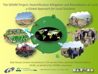
1. Rudi Hessel, Simone Verzandvoort, Erik van den Elsen, and Coen Ritsema (Alterra-
WUR), on behalf of the DESIRE consortium
The DESIRE Project: Desertification Mitigation and Remediation of Land
a Global Approach for Local Solutions
LANDCON1010, October 11-15, Xián, China
2. DESIRE Integrated Project
• Co-funded by the
European Commission (9
M€) in FP6
• 26 partners
• Run-time 2007-2012
• Aim is to define strategies
to combat desertification
in collaboration with
stakeholders
LANDCON1010, October 11-15, Xián, China
www.desire-project.eu
3. LANDCON1010, October 11-15, Xián, China
16 sites with different biophysical manifestations of desertification
5. Thank you for your attention!
For more information, visit:
www.desire-his.eu
www.desire-project.eu
Thanks to all colleagues having
provided photos for this
presentation
Editor's Notes
The methodological framework of DESIRE consists of 4 parts.
Part 1 is about the socio-economic, political and environmental context of the study sites. In this part of the work flow stakeholders are identified and their goals of sustainability, and drivers of desertificiation. Status and risk of land degradation and conservation are assessed using the WOCAT-LADA expert mapping method and an independent indicator assessment (base map of land use systems and mapping questionnaire).
Red box: stakeholder analysis is used.
Brown and orange box: land degradation and conservation mapping using the LADA-WOCAT-DESIRE methodology is used
Orange box: statistical relationships between indicators of deseryification were used, to assess desertification risk and to analyse the effectiveness of SLM practices, to a total of 1641 observations
Part 2 is about the identification of strategies to remedy desertification, to document these, and to prioritize strategies, in all steps in collaboration with stakeholders (internal and external). The L4S and WOCAT QT/QA are used here. In the prioritization phase, a multi-criteria decision support system is used.
Yellow boxes: 3-part participatory framework using WOCAT, LfS , and multicriteria evaluation.
In part 3 selected strategies are trialed and monitored in the field during a period 0f 2-3 years. Stakeholders are involved in the monitoring. Strategies are assessed at site level on criteria partly corresponding to those in the WOCAT QT questionnaire, using various methods (e.g. CBA).
Blue box: field-based methods including scientific and stakeholder monitoring
Dark blue box: PESERA and economic models (e.g. agent-based modelling, input-output modelling)
Results of the local scale assessment are used as input to a coupled model framework consisting of the biophysical PESERA model and economic models (input-output, cost effectiveness, agent-based modelling). These models provide outputs at regional scales, and can be used to identify areas where different remediation strategies are most likely to be adopted by farmers and their likely biophysical impacts.
The proposed grid cell size of 1 ha for the modeling work in WB5 corresponds to the field size and captures an individual farmer’s decision-making. Thus, the model essentially aggregates multiple local (adoption and biophysical) processes. Its added value consists of: i) evaluating the impacts of remediation strategies at the regional scale; and ii) evaluating the effects of policies.
In part 4 of the work entails essentially the spin off of the first three parts, in that dissemination should help to get remediation strategies adopted and implemented. Dissemination will focus on target groups of land managers, national and international policy, and scientists (DESIRE being financed by DG Research). This part of part 4 is covered in DESIRE.
Subsequent activities should include the monitoring of progress to goals. Based on the results of this work, remediation strategies are adjusted, or new remediation strategies may be identified and prioritised in response to changing contexts or because existing strategies are no longer needed or working. These activities should occur in follow up to the DESIRE project.