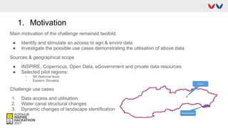
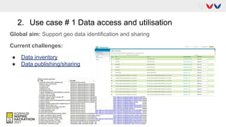
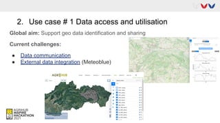
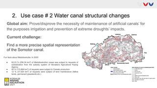
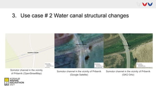
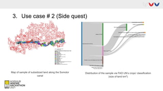
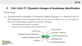
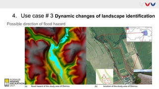
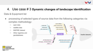
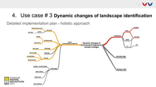
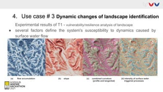
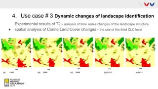
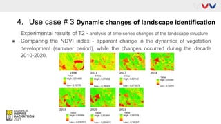
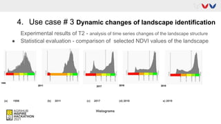
#3 Agro Environmental Services
Martin Tuchyňa
Csaba Sidor
Marcela Bindzárová Gergeľová
Overview 1. Motivation
2. Use case 1
3. Use case 2
4. Use case 3
5. Take away
6. Team behind
1. Motivation
Main motivation of the challenge remained twofold:
● Identify and stimulate an access to agri & enviro data
● Investigate the possible use cases demonstrating the utilisation of above data
Sources & geographical scope
● INSPIRE, Copernicus, Open Data, eGovernment and private data resources
● Selected pilot regions:
○ SK National level
○ Eastern Slovakia
Challenge use cases
1. Data access and utilisation
2. Water canal structural changes
3. Dynamic changes of landscape identification
2. Use case # 1 Data access and utilisation
Global aim: Support geo data identification and sharing
Current challenges:
● Data inventory
● Data publishing/sharing
2. Use case # 1 Data access and utilisation
Global aim: Support geo data identification and sharing
Current challenges:
● Data communication
● External data integration (Meteoblue)
2. Use case # 2 Water canal structural changes
Global aim: Prove/disprove the necessity of maintenance of artificial canals’ for
the purposes irrigation and prevention of extreme droughts’ impacts.
Current challenge:
Find a more precise spatial representation
of the Somotor canal.
Fun facts about Medzibodrožie; In 2020:
● 62.23 % (256.34 km2
) of Medzibodrožie’s areas was subject to requests of
subsidization from the subsidy system of Slovakia’s Agricultural Paying
Agency
● 45 % (115.864 km2
) of requests were subject to Cereals production
● 12 % (31.525 km2
) of requests were subject of land maintenance (fallow
lands, permanent grasslands etc.)
3. Use case # 2 Water canal structural changes
Somotor channel in the vicinity
of Pribeník (OpenStreetMap)
Somotor channel in the vicinity of Pribeník
(Google Satelite)
Somotor channel in the vicinity of Pribeník
(GKÚ Orto)
3. Use case # 2 Water canal structural changes
Sample clip of Tile Cejkov_0-8 segmntation via
Felzenszwalb method
Sample clip of Tile Kralovsky_Chlmec_3-9
segmntation via Felzenszwalb method
3. Use case # 2 (Side quest)
Map of sample of subsidized land along the Somotor
canal
Distribution of the sample via FAO UN’s crops’ classification
(size of land km2
)
4. Use case # 3 Dynamic changes of landscape identification
Current goal
● comprehensive evaluation of temporal spatial changes in a selected part of
the landscape (small fragmented fields with bounds, the influence of an anthropogenic
element (small hydropower plant) and post-flood changes)
○ vulnerability/resilience analysis of landscape
○ analysis of time series changes of the landscape structure
4. Use case # 3 Dynamic changes of landscape identification
Possible direction of flood hazard
(a) flood hazard of the study area of Žehrica (b) location of the study area of Žehrica
4. Use case # 3 Dynamic changes of landscape identification
Data & Equipment list
● processing of selected types of source data from the following categories via
complex methodology:
○ open data
○ satellite data
○ INSPIRE dataset
○ Other registries and
geodatabases
4. Use case # 3 Dynamic changes of landscape identification
Detailed implementation plan - holistic approach
4. Use case # 3 Dynamic changes of landscape identification
Experimental results of T1 - vulnerability/resilience analysis of landscape
● several factors define the system's susceptibility to dynamics caused by
surface water flow
(a) flow accumulation (b) slope (c) combined curvature (d) intenzity of surface water
(profile and tangential) triggered processes
4. Use case # 3 Dynamic changes of landscape identification
Experimental results of T2 - analysis of time series changes of the landscape structure
● spatial analysis of Corine Land Cover changes - the use of the third CLC level
(a) 1990 (b) 2000 (c) 2006 (d) 2012 e) 2012
4. Use case # 3 Dynamic changes of landscape identification
Experimental results of T2 - analysis of time series changes of the landscape structure
● Comparing the NDVI index - apparent change in the dynamics of vegetation
development (summer period), while the changes occurred during the decade
2010-2020.
4. Use case # 3 Dynamic changes of landscape identification
Experimental results of T2 - analysis of time series changes of the landscape structure
● Statistical evaluation - comparison of selected NDVI values of the landscape
(a) 1998 (b) 2011 (c) 2017 (d) 2018 e) 2019
Histograms
5. Take away
● Extension of the availability, usability and communication of spatial data
● Identify tangible motivations, end-users and benefits
● Synergies and unification of the use-cases
● Focus on overall data lifecycle (from collection to use)
6. Team behind
● Marcela Bindzárová Gergeľová (TUKE)
● Radoslav Delina (TUKE)
● Csaba Sidor (TUKE)
● Martin Tuchyňa (ME SR)
● Peter Pastorek (ME SR)
● Monika Supeková (SVP)
● Radovan Hilbert (YMS)
● František Zadražil (Lesprojekt)
● Dmitrii Kozhukh (Plan4All)
● Pavel Hájek (UWB)
● Kinga Dombiová (GCCA SR)
● Christoph Ramshorn (Meteoblue)
Web: Challenge 3
Challenge report
Contacts:
● martin.tuchyna@enviro.gov.sk
● marcela.bindzarova.gergelova
@tuke.sk

Challenge #3 agro environmental services final presentation

  • 1.
    #3 Agro EnvironmentalServices Martin Tuchyňa Csaba Sidor Marcela Bindzárová Gergeľová
  • 2.
    Overview 1. Motivation 2.Use case 1 3. Use case 2 4. Use case 3 5. Take away 6. Team behind
  • 3.
    1. Motivation Main motivationof the challenge remained twofold: ● Identify and stimulate an access to agri & enviro data ● Investigate the possible use cases demonstrating the utilisation of above data Sources & geographical scope ● INSPIRE, Copernicus, Open Data, eGovernment and private data resources ● Selected pilot regions: ○ SK National level ○ Eastern Slovakia Challenge use cases 1. Data access and utilisation 2. Water canal structural changes 3. Dynamic changes of landscape identification
  • 4.
    2. Use case# 1 Data access and utilisation Global aim: Support geo data identification and sharing Current challenges: ● Data inventory ● Data publishing/sharing
  • 5.
    2. Use case# 1 Data access and utilisation Global aim: Support geo data identification and sharing Current challenges: ● Data communication ● External data integration (Meteoblue)
  • 6.
    2. Use case# 2 Water canal structural changes Global aim: Prove/disprove the necessity of maintenance of artificial canals’ for the purposes irrigation and prevention of extreme droughts’ impacts. Current challenge: Find a more precise spatial representation of the Somotor canal. Fun facts about Medzibodrožie; In 2020: ● 62.23 % (256.34 km2 ) of Medzibodrožie’s areas was subject to requests of subsidization from the subsidy system of Slovakia’s Agricultural Paying Agency ● 45 % (115.864 km2 ) of requests were subject to Cereals production ● 12 % (31.525 km2 ) of requests were subject of land maintenance (fallow lands, permanent grasslands etc.)
  • 7.
    3. Use case# 2 Water canal structural changes Somotor channel in the vicinity of Pribeník (OpenStreetMap) Somotor channel in the vicinity of Pribeník (Google Satelite) Somotor channel in the vicinity of Pribeník (GKÚ Orto)
  • 8.
    3. Use case# 2 Water canal structural changes Sample clip of Tile Cejkov_0-8 segmntation via Felzenszwalb method Sample clip of Tile Kralovsky_Chlmec_3-9 segmntation via Felzenszwalb method
  • 9.
    3. Use case# 2 (Side quest) Map of sample of subsidized land along the Somotor canal Distribution of the sample via FAO UN’s crops’ classification (size of land km2 )
  • 10.
    4. Use case# 3 Dynamic changes of landscape identification Current goal ● comprehensive evaluation of temporal spatial changes in a selected part of the landscape (small fragmented fields with bounds, the influence of an anthropogenic element (small hydropower plant) and post-flood changes) ○ vulnerability/resilience analysis of landscape ○ analysis of time series changes of the landscape structure
  • 11.
    4. Use case# 3 Dynamic changes of landscape identification Possible direction of flood hazard (a) flood hazard of the study area of Žehrica (b) location of the study area of Žehrica
  • 12.
    4. Use case# 3 Dynamic changes of landscape identification Data & Equipment list ● processing of selected types of source data from the following categories via complex methodology: ○ open data ○ satellite data ○ INSPIRE dataset ○ Other registries and geodatabases
  • 13.
    4. Use case# 3 Dynamic changes of landscape identification Detailed implementation plan - holistic approach
  • 14.
    4. Use case# 3 Dynamic changes of landscape identification Experimental results of T1 - vulnerability/resilience analysis of landscape ● several factors define the system's susceptibility to dynamics caused by surface water flow (a) flow accumulation (b) slope (c) combined curvature (d) intenzity of surface water (profile and tangential) triggered processes
  • 15.
    4. Use case# 3 Dynamic changes of landscape identification Experimental results of T2 - analysis of time series changes of the landscape structure ● spatial analysis of Corine Land Cover changes - the use of the third CLC level (a) 1990 (b) 2000 (c) 2006 (d) 2012 e) 2012
  • 16.
    4. Use case# 3 Dynamic changes of landscape identification Experimental results of T2 - analysis of time series changes of the landscape structure ● Comparing the NDVI index - apparent change in the dynamics of vegetation development (summer period), while the changes occurred during the decade 2010-2020.
  • 17.
    4. Use case# 3 Dynamic changes of landscape identification Experimental results of T2 - analysis of time series changes of the landscape structure ● Statistical evaluation - comparison of selected NDVI values of the landscape (a) 1998 (b) 2011 (c) 2017 (d) 2018 e) 2019 Histograms
  • 18.
    5. Take away ●Extension of the availability, usability and communication of spatial data ● Identify tangible motivations, end-users and benefits ● Synergies and unification of the use-cases ● Focus on overall data lifecycle (from collection to use)
  • 19.
    6. Team behind ●Marcela Bindzárová Gergeľová (TUKE) ● Radoslav Delina (TUKE) ● Csaba Sidor (TUKE) ● Martin Tuchyňa (ME SR) ● Peter Pastorek (ME SR) ● Monika Supeková (SVP) ● Radovan Hilbert (YMS) ● František Zadražil (Lesprojekt) ● Dmitrii Kozhukh (Plan4All) ● Pavel Hájek (UWB) ● Kinga Dombiová (GCCA SR) ● Christoph Ramshorn (Meteoblue)
  • 20.
    Web: Challenge 3 Challengereport Contacts: ● martin.tuchyna@enviro.gov.sk ● marcela.bindzarova.gergelova @tuke.sk