Burkina Faso Flying Labs Newsletters 2019
•
0 likes•41 views
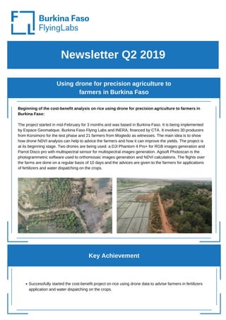
The project started in mid-February in Burkina Faso to analyze the benefits of using drones to provide precision agriculture advice to rice farmers. The project involves 30 farmers testing the drone analysis and 21 additional farmers observing. Drones capture RGB and multispectral images every 10 days to calculate NDVI maps and advise farmers on fertilizer and water applications. The goal is to demonstrate how drone data can improve rice yields. So far, the project has successfully started providing drone-based advice to farmers.
Report
Share
Report
Share
Download to read offline

Recommended
Nrcri ext presentation
This document summarizes the dissemination of improved weed management practices to cassava farmers in Benue State, Nigeria. Community leaders were engaged to gain their support. On-farm demonstrations of techniques were established and farmers' field days hosted hundreds of participants. Modular trainings on best practices and safe herbicide use reached over 4,000 farmers. Agrodealers and other partners were also trained to aid dissemination. Farmers reported improved yields and reduced weed problems with the new methods. The project was implemented by IITA and several state programs, with funding support from the Nigerian government.
Uganda Flying Labs Newsletters 2019
The document summarizes several activities by Uganda Flying Labs:
1. Uganda Flying Labs conducted a workshop to help professionals in insurance, medical diagnostics, and drug delivery fields learn how drone technology could improve their services. They also worked with the Ministry of Security to regulate drone use in Uganda.
2. To celebrate Flying Labs Day, Uganda Flying Labs hosted an open house where they showcased drones and their applications to university students, GIS experts, medical professionals, and journalists.
3. Uganda Flying Labs provided intermediate drone training over two days where participants learned field missions, image processing, and analysis to create maps. They captured good imagery that produced clear orthomosaics and digital surface models.
West Africa - Summary of development and delivery activities for out-scaling...
West Africa - Summary of development and delivery activities for out-scaling...International Institute of Tropical Agriculture
The document summarizes development and delivery activities in 2016 for out-scaling agricultural research technologies in West Africa, and plans for 2017. In 2016, technologies for crops like maize, cassava, and yam were delivered to farmers through 35 projects totaling $266 million. Specifically, the Yam Improvement for Incomes and Food Security in West Africa project introduced virus-free propagation methods, aeroponics systems, and quality management to over 120,000 farmers. Plans for 2017 include further disseminating seed yam production using aeroponics and one-node vine cuttings to additional farmers and seed companies across Nigeria and Ghana.AARINENA Activity Report, Dr. I. Hamdan
This document provides an activity report for AARINENA (The Arab Network for Agriculture Research and Development) for 2007-2008. It summarizes AARINENA's mission, work plan, progress on key initiatives like the Regional Agricultural Information System and technical networks, and planned future activities. Key accomplishments include strengthening the AARINENA website and networks in areas like date palm, cotton, and biotechnology. Inter-regional collaboration with organizations like FARA, APAARI, and ERA-ARD was also discussed.
Report on the Third Industrial Development Decade for Africa (IDDA III).
This document provides a report on progress made in implementing the Third Industrial Development Decade for Africa (IDDA III). It summarizes UNIDO's technical assistance activities in Africa in 2022, including projects in agribusiness, entrepreneurship, energy/environment, and trade capacity building. It also describes collaboration with other organizations to support initiatives like Common African Agro-Parks. Upcoming activities are outlined, such as developing an Africa Strategy, implementing the AU Action Plan, and convening the 2023 Africa Industrialization Week. The Committee is invited to take note of the information in the report.
PNG Flying Labs Newsletters 2019
PNG Flying Labs partnered with IBSUniversity to host a free drone safety workshop in Port Moresby, where they shared local and global perspectives on drone safety and regulations and provided certificates to participants who completed an evaluation; the workshop was part of PNG Flying Labs' ongoing drone education efforts at universities in PNG. Key speakers at the workshop included the Deputy Prime Minister of PNG and the Chief Operating Officer of the Civil Aviation Safety Authority.
Kenya Flying Labs Newsletters 2019
The document summarizes activities from Kenya Flying Labs in Q2 2019, including visiting a proposed drone corridor site in Machakos County, partnering with Jomo Kenyatta University of Agriculture and Technology (JKUAT) on drone research and training, and attending a public forum on Kenya's draft drone regulations. It also mentions projects using drones to map tourist sites in Machakos County and monitor forest health in collaboration with FAO, KFS and KWS.
Cote d'Ivoire Flying Labs Newsletter 2019
Côte d'Ivoire Flying Labs celebrated Flying Labs Day on September 25th in Abidjan to promote the sustainable use of drones. There are now over 22 Flying Labs worldwide established since 2015 when drones were first used effectively in Nepal after an earthquake. Côte d'Ivoire Flying Labs was created in 2018 through a partnership between WeRobotics and Investiv to implement drone projects. Their recent activities included a successful Fly Girl Program training high school girls, and participating in flood assessment in Grand Bassam with the World Bank. Upcoming projects involve using drones for cocoa certification and spraying in agriculture.
6 Casimiraitchedji Pics
The document discusses the Purdue Improved Cowpea Storage (PICS) project, which aims to promote the use of hermetic storage bags (PICS bags) for storing cowpeas in West and Central Africa. The project plans to reach 50% of cowpea storage in the region using non-chemical hermetic methods by 2012. It outlines the project's approach of training farmers, demonstrating the technology, and ensuring bag availability. It also provides examples of project activities in Nigeria, including demonstrations held in villages, and research to evaluate the technology's effectiveness under farmers' conditions.
Defining An Intellectual Property Policy For INERA Burkina Faso
Defining An Intellectual Property Policy For INERA Burkina FasoCGIAR Central Advisory Service on Intellectual Property
In this case study, the author describes her methodology for creating awareness in IP management and implementing the IP policy for INERA, a national research institute in Burkina Faso. As a public entity, INERA has the mandate to ensure the formulation, implementation and coordination of environmental and agricultural research in Burkina Faso. INERA has produced many scientific results and innovations that are placed in the public domain which are promoted essentially through direct exploitation by producers and scientists, and the publication of scientific papers. The present paper emphasizes the need to sensitise and increase the awareness of scientists in IP issues to encourage their participation in IP policy implementation and assets evaluation. Difficulties encountered during the study include lack of awareness of IP issues and low understanding of IP-related legislations. The paper further recommends an implementation of a general IP policy in research at national and regional level in the framework of CORAF/WECARD. Sensitisation through workshops and meetings is essential to increase awareness of scientists and the various actors involved in the promotion of research results.Registering a GI in coffee from Mont Ziama, Guinée
Presentation hold by Marie Antoinette Haba, Head of cooperation and development, Ministry of Agriculture and focal point on GIs of OAPI, at the Brussels Briefing ‘Geography of food: reconnecting with origin in the food system’, organized by CTA on 15th May 2013.
More on: http://brusselsbriefings.net/
Morocco Flying Labs Newsletters 2019
1. The Morocco Flying Labs newsletter provides updates on their projects, events, and achievements over the past quarter. They participated in an AI day event in November 2018 and organized deep learning training in March 2019.
2. Key projects discussed include the Skynet drone surveillance system, FishGuard illegal fishing monitoring in Seychelles, and a drone flight simulator. They are also proposing new projects on search and rescue and refugee operations.
3. Upcoming events include an international workshop on robotics and AI in September 2019 and continued work on various ongoing projects and proposals.
CONTROL OF ANGULAR LEAF SPOT OF CITRUS IN GHANA
- The document summarizes the activities of citrus innovation platforms (CIPs) established in Ghana to address angular leaf spot disease affecting the citrus industry.
- With funding from FARA and the EC, three CIPs were launched in 2014 in Mankranso, Assin Foso, and Kade to bring together stakeholders to jointly address priority constraints.
- The CIPs have trained farmers in good agricultural practices, conducted research on the disease and fruit flies, and established a WhatsApp group to improve communication. Over 3,000 farmers have adopted the technologies developed, improving fruit quality, quantity and incomes.
IFPRI RISE 2019
The document summarizes several current projects being undertaken by IFPRI's Africa Region division.
It first discusses predictive modeling plans for Agriculture Watch to forecast crop status, climate, land use and cover changes, and yields using remote sensing data and machine learning. Initial results show good prediction of vegetation indices in Senegal.
It then summarizes support provided to five countries to improve data quality for the CAADP biennial review process. Pilot activities were found to increase reporting rates and reduce data issues compared to non-pilot countries.
Finally, it presents on work by the Malabo Montpellier Panel to facilitate African policy choices through country case studies and reports on issues like water management and digital agriculture.
Agro IR 4.0-smart and next generation agro-farming-Fab labs to make anything
Agriculture 4.0 is a term for the next big trends facing the industry, including a greater focus on precision agriculture, the internet of things (IoT) and the use of big data to drive greater business efficiencies in the face of rising populations and climate change. Makerspaces or Fab labs around the world can contribute in big margin to make prototypes reducing cost and makerspaces will be actions towards IR 4.0 in Bangladesh
Artificial Intelligence in Agriculture
AI bots in the agriculture field can harvest crops at a higher volume and faster pace than human laborers. By leveraging computer vision helps to monitor the weed and spray them. Thus, Artificial Intelligence is helping farmers find more efficient ways to protect their crops from weeds.
Benin Flying Labs Newsletters 2019
Global Partners
Objective: Train participants in basic drone piloting skills.
Participants: Students, professionals, development actors, etc.
Number of participants: 10
Outcome:
- Participants acquired basic knowledge of drones and piloting.
- Participants know how to manually pilot DJI Phantom 4 drones.
- Participants received piloting certificates.
Workshop on the use of drones in local development:
Date and place: 24 January, Dassa-Zoumè
Partners: WeRobotics, GIC, Dassa-Zoumè City Hall
Objective: Present the results of the Dassa-Zoumè drone mapping project and discuss
Virtual training in the use of remote sensing for the agriculture sector in P...
A virtual hands-on training program on developing geospatial maps for supporting insurance products using Google Earth Engine and semi-automatic techniques was conducted for participants in Pakistan as part of the project “Strengthening Post-COVID-19 Food Security and Locust Attacks”. The nine participants were from the PARC Agrotech company (PATCO) technical team and crop reporting service teams from Punjab and Sindh in Pakistan. They were introduced to remote sensing and its applications in agriculture. Hands-on training using Google Earth Engine (GEE), Image Processing Software – ERDAS 2015 and various automatic classification techniques was provided along with several applications for using these modern tools.
Management of Drought and Desertification for Sustainable Agricultural Develo...
It is no gain saying today that uncontrolled and uncoordinated roles of man are responsible for geo-environmental degradation in Nigeria, be it intentional or inadvertent. Take for instance, Nigeria which will be the focus of this paper has some conservation legislations currently in force and yet the state has not and may never recover from devastating drought years. Many failed measures have been advanced as efforts to improving the productivity of the needed potential of large expanse of land put under cultivation proved unsuccessful. That is, all the measures ever launched to improve agricultural output are not yielding much needed positive results. This is partly due to poor management during persistent drought spells. However, this paper sets to unravel the drought management skills that could be employed to actualise agricultural sustainability. Basically, literature search of information from articles from Google scholar, libraries, etc. as well as personal survey to federal and state ministry of agriculture were exploited. It may be safe to state, therefore, that designing strategies to control or curb drought should take advantage of archived data for present and future research studies that may help arrest the seemingly physical march of the Sahara Desert into West Africa.
Farmers’ Hubs for quality seed and input supply and market linkage launched i...
The Syngenta Foundation for Sustainable Agriculture (SFSA) launched 13 Farmers’ Hubs to service 13,000 sorghum and cowpea farmers in Kano and Jigawa States. The initiative was in response to survey findings on low farm yields attributed to difficult access to quality seeds, inputs and adulterated agro-chemicals (including adulterated fertilizers) in Northern Nigeria.
National rice development strategy of Nigeria
The National Rice Development Strategy (NRDS) document outlines Nigeria's plan to increase rice production over the next 10 years. It identifies the following key priorities:
1) Processing and marketing of rice to improve quality and competitiveness. This will include establishing new processing mills, developing quality standards, and conducting surveys.
2) Land and irrigation development by rehabilitating existing irrigation schemes, clearing new land, and increasing farm mechanization.
3) Rice production inputs by subsidizing seeds, fertilizers, and improving availability. The strategy aims to double rice production in Nigeria to over 12 million tons by 2018 through focus on these priority areas of processing, land development, and inputs supply.
IBP/IFAD Project - Enhancing institutional breeding capacity in Ghana, Senega...
IBP/IFAD Project - Enhancing institutional breeding capacity in Ghana, Senega...Africa Rice Center (AfricaRice)
IBP/IFAD Project - Enhancing institutional breeding capacity in Ghana, Senegal and Uganda to develop climate resilient crops for African smallholder farmers
Gorgui Alioune Mbow
Regional Deployment Manager – West & Central Africa
IBP/IFAD Project Coordinator Cassava Weed Management Project June Newsletter 004
This document discusses preliminary results from a study on improved weed management practices for cassava farmers in Nigeria. The key points are:
1) Experimental plots showed that adopting improved weed control practices could double cassava yields for Nigerian farmers, increasing average yields from 12-13 tons per hectare to 20-39 tons per hectare.
2) In controlled experimental plots with improved weed management, a single cassava plant produced 34 kilograms of roots, compared to the average national yield of 1.2-1.3 kg per plant.
3) Weeds typically reduce cassava yields by 80% in uncontrolled fields. The study demonstrates that ensuring fields remain weed-free can significantly increase production.
Banana Micropropagation_DA-RFO 7 .INCEPTION MEETING [Autosaved] - Copy.pptx
This document provides details of a proposed project to increase banana production through micropropagation techniques in Central Visayas, Philippines. The project aims to (1) efficiently produce quality banana planting materials using micropropagation, (2) accelerate plantlet production and adoption, (3) enhance farmer capacities, and (4) develop strategies to sustain supply. It will produce 15,000 plantlets annually at three stations for distribution to farmers. Activities include training farmers, establishing demonstrations, and developing a scheme for farmers to repay materials with their harvest and supply other farmers. The project requests PHP 2,822,893.30 over two years to achieve these goals.
Cosp presentation at the project end of year 1 meeting
Cosp presentation at the project end of year 1 meetingInternational Institute of Tropical Agriculture
This document summarizes the status of activities for a USAID cowpea project in West Africa in its first year. It outlines seed distribution efforts, training of community seed producers, establishment of demonstrations of best practices, and efforts to promote improved storage, home consumption, and market linkages. It notes progress establishing innovation platforms in target districts and initializing baseline surveys. Challenges and plans for collaboration with other projects are also mentioned. The project aims to scale improved cowpea varieties and technologies across three regions in its first year.Farmer-oriented innovation: outcomes from a first bootcamp
An interdisciplinary team held a bootcamp to develop farmer-oriented innovation projects using open-source technologies like Arduino and Raspberry Pi. Four projects were developed by farmers and students to monitor various agricultural data through IoT sensors and provide alerts or analyses to farmers. The bootcamp achieved its goals of enabling participants to innovate using affordable open-source tools and providing a model for future collaboration between farmers, students, and experts to develop precision agriculture solutions.
An overview of weeding by robots – focus on European solutions
This presentation addressed an overview of the European context, mowing towards data-intensive farming, driven by the agfood sector. It is an invited presentation in the framework of a meeting coordinated by Matthew Cutulle (Clemson University) for a Specialty Crop Research Initiative (SCRI) planning grant about Robotic Weed Control in Specialty Crops. The meeting was organized as a side event during the Southeast Regional Fruit and Vegetable Conference. The presentation provides an overview of European trends on the topic, with a focus on the French institutional perspective aiming at the support and development of agricultural robotics to face the lack of labour and the willingness to phase out glyphosate. In this context, the RobAgri association was presented. The last part lists some sources of information about agricultural robotics, with a list of European sources of information on agricultural robotics and automation. The presentation ends with a list of robot examples that were compared from the agronomic point of view.
Profitability of Actors in the Value Chain of Commercial Rice
This qualitative study explored the value chain of commercial rice in Nueva Vizcaya, Philippines. It presented the value chain map of commercial rice highlighting the profitability of each actor involved in the value chain, namely paddy rice farmers, primary traders, millers, retailers, and final traders (wholesalers and retailers). The findings revealed that the miller contributes the highest value-added cost to commercial rice production, accounting for approximately 40.39% of the total, followed closely by the farmers at 39.22%. The primary trader represented 10.93%, while the wholesaler and retailer contributed 6.72% and 2.07% respectively. Analysis of the percentage of profit to cost showed that farmers earned the highest percentage at 32.36%, followed by the retailer at 8.48%, the primary trader at 5.11%, the miller at 2.32%, and the wholesaler at 1.68%. However, when considering the operating cycle of each actor, it became apparent that the primary trader emerged as the highest-earning actor due to their shorter operating cycle compared to other actors in the value chain. Hence, venturing into paddy rice production, trading, milling, and wholesaling of commercial rice in Nueva Vizcaya is profitable, given the wide market demand for rice as a staple food. There is a viable opportunity to enhance profitability among the various actors in the value chain, particularly for farmers, by leveraging appropriate government support programs, specifically by maximizing the utilization of initiatives provided under the Rice Tariffication Law.
South Pacific Flying Labs Newsletters 2019
A landslide in February destroyed homes in the remote Fijian village of Draubuta. In July, teams from the National Disaster Management Office and South Pacific Flying Labs used drones equipped with survey equipment to map the landslide damage and plan for village relocation. Digital maps and models were created to identify at-risk areas and plan future development. The drone mapping aided relocation efforts after the devastating landslide.
Zambia Flying Labs Newsletters 2019
Zambia Flying Labs celebrated Annual Flying Labs Day under the theme "Drones for STEM Education for the Hearing-Impaired". The event included career talks on science, technology, engineering and math careers as well as interactive drone demonstrations. 114 pupils participated in the event and received certificates. The school raised concerns about the lack of support for STEM programs for hearing-impaired and physically challenged youth in higher education.
More Related Content
Similar to Burkina Faso Flying Labs Newsletters 2019
6 Casimiraitchedji Pics
The document discusses the Purdue Improved Cowpea Storage (PICS) project, which aims to promote the use of hermetic storage bags (PICS bags) for storing cowpeas in West and Central Africa. The project plans to reach 50% of cowpea storage in the region using non-chemical hermetic methods by 2012. It outlines the project's approach of training farmers, demonstrating the technology, and ensuring bag availability. It also provides examples of project activities in Nigeria, including demonstrations held in villages, and research to evaluate the technology's effectiveness under farmers' conditions.
Defining An Intellectual Property Policy For INERA Burkina Faso
Defining An Intellectual Property Policy For INERA Burkina FasoCGIAR Central Advisory Service on Intellectual Property
In this case study, the author describes her methodology for creating awareness in IP management and implementing the IP policy for INERA, a national research institute in Burkina Faso. As a public entity, INERA has the mandate to ensure the formulation, implementation and coordination of environmental and agricultural research in Burkina Faso. INERA has produced many scientific results and innovations that are placed in the public domain which are promoted essentially through direct exploitation by producers and scientists, and the publication of scientific papers. The present paper emphasizes the need to sensitise and increase the awareness of scientists in IP issues to encourage their participation in IP policy implementation and assets evaluation. Difficulties encountered during the study include lack of awareness of IP issues and low understanding of IP-related legislations. The paper further recommends an implementation of a general IP policy in research at national and regional level in the framework of CORAF/WECARD. Sensitisation through workshops and meetings is essential to increase awareness of scientists and the various actors involved in the promotion of research results.Registering a GI in coffee from Mont Ziama, Guinée
Presentation hold by Marie Antoinette Haba, Head of cooperation and development, Ministry of Agriculture and focal point on GIs of OAPI, at the Brussels Briefing ‘Geography of food: reconnecting with origin in the food system’, organized by CTA on 15th May 2013.
More on: http://brusselsbriefings.net/
Morocco Flying Labs Newsletters 2019
1. The Morocco Flying Labs newsletter provides updates on their projects, events, and achievements over the past quarter. They participated in an AI day event in November 2018 and organized deep learning training in March 2019.
2. Key projects discussed include the Skynet drone surveillance system, FishGuard illegal fishing monitoring in Seychelles, and a drone flight simulator. They are also proposing new projects on search and rescue and refugee operations.
3. Upcoming events include an international workshop on robotics and AI in September 2019 and continued work on various ongoing projects and proposals.
CONTROL OF ANGULAR LEAF SPOT OF CITRUS IN GHANA
- The document summarizes the activities of citrus innovation platforms (CIPs) established in Ghana to address angular leaf spot disease affecting the citrus industry.
- With funding from FARA and the EC, three CIPs were launched in 2014 in Mankranso, Assin Foso, and Kade to bring together stakeholders to jointly address priority constraints.
- The CIPs have trained farmers in good agricultural practices, conducted research on the disease and fruit flies, and established a WhatsApp group to improve communication. Over 3,000 farmers have adopted the technologies developed, improving fruit quality, quantity and incomes.
IFPRI RISE 2019
The document summarizes several current projects being undertaken by IFPRI's Africa Region division.
It first discusses predictive modeling plans for Agriculture Watch to forecast crop status, climate, land use and cover changes, and yields using remote sensing data and machine learning. Initial results show good prediction of vegetation indices in Senegal.
It then summarizes support provided to five countries to improve data quality for the CAADP biennial review process. Pilot activities were found to increase reporting rates and reduce data issues compared to non-pilot countries.
Finally, it presents on work by the Malabo Montpellier Panel to facilitate African policy choices through country case studies and reports on issues like water management and digital agriculture.
Agro IR 4.0-smart and next generation agro-farming-Fab labs to make anything
Agriculture 4.0 is a term for the next big trends facing the industry, including a greater focus on precision agriculture, the internet of things (IoT) and the use of big data to drive greater business efficiencies in the face of rising populations and climate change. Makerspaces or Fab labs around the world can contribute in big margin to make prototypes reducing cost and makerspaces will be actions towards IR 4.0 in Bangladesh
Artificial Intelligence in Agriculture
AI bots in the agriculture field can harvest crops at a higher volume and faster pace than human laborers. By leveraging computer vision helps to monitor the weed and spray them. Thus, Artificial Intelligence is helping farmers find more efficient ways to protect their crops from weeds.
Benin Flying Labs Newsletters 2019
Global Partners
Objective: Train participants in basic drone piloting skills.
Participants: Students, professionals, development actors, etc.
Number of participants: 10
Outcome:
- Participants acquired basic knowledge of drones and piloting.
- Participants know how to manually pilot DJI Phantom 4 drones.
- Participants received piloting certificates.
Workshop on the use of drones in local development:
Date and place: 24 January, Dassa-Zoumè
Partners: WeRobotics, GIC, Dassa-Zoumè City Hall
Objective: Present the results of the Dassa-Zoumè drone mapping project and discuss
Virtual training in the use of remote sensing for the agriculture sector in P...
A virtual hands-on training program on developing geospatial maps for supporting insurance products using Google Earth Engine and semi-automatic techniques was conducted for participants in Pakistan as part of the project “Strengthening Post-COVID-19 Food Security and Locust Attacks”. The nine participants were from the PARC Agrotech company (PATCO) technical team and crop reporting service teams from Punjab and Sindh in Pakistan. They were introduced to remote sensing and its applications in agriculture. Hands-on training using Google Earth Engine (GEE), Image Processing Software – ERDAS 2015 and various automatic classification techniques was provided along with several applications for using these modern tools.
Management of Drought and Desertification for Sustainable Agricultural Develo...
It is no gain saying today that uncontrolled and uncoordinated roles of man are responsible for geo-environmental degradation in Nigeria, be it intentional or inadvertent. Take for instance, Nigeria which will be the focus of this paper has some conservation legislations currently in force and yet the state has not and may never recover from devastating drought years. Many failed measures have been advanced as efforts to improving the productivity of the needed potential of large expanse of land put under cultivation proved unsuccessful. That is, all the measures ever launched to improve agricultural output are not yielding much needed positive results. This is partly due to poor management during persistent drought spells. However, this paper sets to unravel the drought management skills that could be employed to actualise agricultural sustainability. Basically, literature search of information from articles from Google scholar, libraries, etc. as well as personal survey to federal and state ministry of agriculture were exploited. It may be safe to state, therefore, that designing strategies to control or curb drought should take advantage of archived data for present and future research studies that may help arrest the seemingly physical march of the Sahara Desert into West Africa.
Farmers’ Hubs for quality seed and input supply and market linkage launched i...
The Syngenta Foundation for Sustainable Agriculture (SFSA) launched 13 Farmers’ Hubs to service 13,000 sorghum and cowpea farmers in Kano and Jigawa States. The initiative was in response to survey findings on low farm yields attributed to difficult access to quality seeds, inputs and adulterated agro-chemicals (including adulterated fertilizers) in Northern Nigeria.
National rice development strategy of Nigeria
The National Rice Development Strategy (NRDS) document outlines Nigeria's plan to increase rice production over the next 10 years. It identifies the following key priorities:
1) Processing and marketing of rice to improve quality and competitiveness. This will include establishing new processing mills, developing quality standards, and conducting surveys.
2) Land and irrigation development by rehabilitating existing irrigation schemes, clearing new land, and increasing farm mechanization.
3) Rice production inputs by subsidizing seeds, fertilizers, and improving availability. The strategy aims to double rice production in Nigeria to over 12 million tons by 2018 through focus on these priority areas of processing, land development, and inputs supply.
IBP/IFAD Project - Enhancing institutional breeding capacity in Ghana, Senega...
IBP/IFAD Project - Enhancing institutional breeding capacity in Ghana, Senega...Africa Rice Center (AfricaRice)
IBP/IFAD Project - Enhancing institutional breeding capacity in Ghana, Senegal and Uganda to develop climate resilient crops for African smallholder farmers
Gorgui Alioune Mbow
Regional Deployment Manager – West & Central Africa
IBP/IFAD Project Coordinator Cassava Weed Management Project June Newsletter 004
This document discusses preliminary results from a study on improved weed management practices for cassava farmers in Nigeria. The key points are:
1) Experimental plots showed that adopting improved weed control practices could double cassava yields for Nigerian farmers, increasing average yields from 12-13 tons per hectare to 20-39 tons per hectare.
2) In controlled experimental plots with improved weed management, a single cassava plant produced 34 kilograms of roots, compared to the average national yield of 1.2-1.3 kg per plant.
3) Weeds typically reduce cassava yields by 80% in uncontrolled fields. The study demonstrates that ensuring fields remain weed-free can significantly increase production.
Banana Micropropagation_DA-RFO 7 .INCEPTION MEETING [Autosaved] - Copy.pptx
This document provides details of a proposed project to increase banana production through micropropagation techniques in Central Visayas, Philippines. The project aims to (1) efficiently produce quality banana planting materials using micropropagation, (2) accelerate plantlet production and adoption, (3) enhance farmer capacities, and (4) develop strategies to sustain supply. It will produce 15,000 plantlets annually at three stations for distribution to farmers. Activities include training farmers, establishing demonstrations, and developing a scheme for farmers to repay materials with their harvest and supply other farmers. The project requests PHP 2,822,893.30 over two years to achieve these goals.
Cosp presentation at the project end of year 1 meeting
Cosp presentation at the project end of year 1 meetingInternational Institute of Tropical Agriculture
This document summarizes the status of activities for a USAID cowpea project in West Africa in its first year. It outlines seed distribution efforts, training of community seed producers, establishment of demonstrations of best practices, and efforts to promote improved storage, home consumption, and market linkages. It notes progress establishing innovation platforms in target districts and initializing baseline surveys. Challenges and plans for collaboration with other projects are also mentioned. The project aims to scale improved cowpea varieties and technologies across three regions in its first year.Farmer-oriented innovation: outcomes from a first bootcamp
An interdisciplinary team held a bootcamp to develop farmer-oriented innovation projects using open-source technologies like Arduino and Raspberry Pi. Four projects were developed by farmers and students to monitor various agricultural data through IoT sensors and provide alerts or analyses to farmers. The bootcamp achieved its goals of enabling participants to innovate using affordable open-source tools and providing a model for future collaboration between farmers, students, and experts to develop precision agriculture solutions.
An overview of weeding by robots – focus on European solutions
This presentation addressed an overview of the European context, mowing towards data-intensive farming, driven by the agfood sector. It is an invited presentation in the framework of a meeting coordinated by Matthew Cutulle (Clemson University) for a Specialty Crop Research Initiative (SCRI) planning grant about Robotic Weed Control in Specialty Crops. The meeting was organized as a side event during the Southeast Regional Fruit and Vegetable Conference. The presentation provides an overview of European trends on the topic, with a focus on the French institutional perspective aiming at the support and development of agricultural robotics to face the lack of labour and the willingness to phase out glyphosate. In this context, the RobAgri association was presented. The last part lists some sources of information about agricultural robotics, with a list of European sources of information on agricultural robotics and automation. The presentation ends with a list of robot examples that were compared from the agronomic point of view.
Profitability of Actors in the Value Chain of Commercial Rice
This qualitative study explored the value chain of commercial rice in Nueva Vizcaya, Philippines. It presented the value chain map of commercial rice highlighting the profitability of each actor involved in the value chain, namely paddy rice farmers, primary traders, millers, retailers, and final traders (wholesalers and retailers). The findings revealed that the miller contributes the highest value-added cost to commercial rice production, accounting for approximately 40.39% of the total, followed closely by the farmers at 39.22%. The primary trader represented 10.93%, while the wholesaler and retailer contributed 6.72% and 2.07% respectively. Analysis of the percentage of profit to cost showed that farmers earned the highest percentage at 32.36%, followed by the retailer at 8.48%, the primary trader at 5.11%, the miller at 2.32%, and the wholesaler at 1.68%. However, when considering the operating cycle of each actor, it became apparent that the primary trader emerged as the highest-earning actor due to their shorter operating cycle compared to other actors in the value chain. Hence, venturing into paddy rice production, trading, milling, and wholesaling of commercial rice in Nueva Vizcaya is profitable, given the wide market demand for rice as a staple food. There is a viable opportunity to enhance profitability among the various actors in the value chain, particularly for farmers, by leveraging appropriate government support programs, specifically by maximizing the utilization of initiatives provided under the Rice Tariffication Law.
Similar to Burkina Faso Flying Labs Newsletters 2019 (20)
Defining An Intellectual Property Policy For INERA Burkina Faso
Defining An Intellectual Property Policy For INERA Burkina Faso
Registering a GI in coffee from Mont Ziama, Guinée
Registering a GI in coffee from Mont Ziama, Guinée
Agro IR 4.0-smart and next generation agro-farming-Fab labs to make anything
Agro IR 4.0-smart and next generation agro-farming-Fab labs to make anything
Virtual training in the use of remote sensing for the agriculture sector in P...
Virtual training in the use of remote sensing for the agriculture sector in P...
Management of Drought and Desertification for Sustainable Agricultural Develo...
Management of Drought and Desertification for Sustainable Agricultural Develo...
Farmers’ Hubs for quality seed and input supply and market linkage launched i...
Farmers’ Hubs for quality seed and input supply and market linkage launched i...
IBP/IFAD Project - Enhancing institutional breeding capacity in Ghana, Senega...
IBP/IFAD Project - Enhancing institutional breeding capacity in Ghana, Senega...
Cassava Weed Management Project June Newsletter 004
Cassava Weed Management Project June Newsletter 004
Banana Micropropagation_DA-RFO 7 .INCEPTION MEETING [Autosaved] - Copy.pptx
Banana Micropropagation_DA-RFO 7 .INCEPTION MEETING [Autosaved] - Copy.pptx
Cosp presentation at the project end of year 1 meeting
Cosp presentation at the project end of year 1 meeting
Farmer-oriented innovation: outcomes from a first bootcamp
Farmer-oriented innovation: outcomes from a first bootcamp
An overview of weeding by robots – focus on European solutions
An overview of weeding by robots – focus on European solutions
Profitability of Actors in the Value Chain of Commercial Rice
Profitability of Actors in the Value Chain of Commercial Rice
More from Uyangaa Munkhbat
South Pacific Flying Labs Newsletters 2019
A landslide in February destroyed homes in the remote Fijian village of Draubuta. In July, teams from the National Disaster Management Office and South Pacific Flying Labs used drones equipped with survey equipment to map the landslide damage and plan for village relocation. Digital maps and models were created to identify at-risk areas and plan future development. The drone mapping aided relocation efforts after the devastating landslide.
Zambia Flying Labs Newsletters 2019
Zambia Flying Labs celebrated Annual Flying Labs Day under the theme "Drones for STEM Education for the Hearing-Impaired". The event included career talks on science, technology, engineering and math careers as well as interactive drone demonstrations. 114 pupils participated in the event and received certificates. The school raised concerns about the lack of support for STEM programs for hearing-impaired and physically challenged youth in higher education.
Tanzania Flying Labs Newsletter 2019
The document provides summaries of several projects and trainings conducted by Tanzania Flying Labs:
1) A new STEAM program called STEAMB TS was introduced, focusing on girls and students from various backgrounds. Students learned about drone piloting and data analysis.
2) Drone data analysis courses were facilitated in Dar es Salaam and Arusha to teach skills important for the fourth industrial revolution.
3) A drone mapping training was held in Mtwara to teach participants skills like flight planning, data collection and analysis, and mapping mangroves.
4) Upcoming projects include using drones to map land for a solar power plant and participatory mapping in Meatu District to improve land rights
Sierra Leone Flying Labs Newsletters 2019
On August 22nd, Sierra Leone Flying Labs held an open house event with the goal of understanding the drone and robotics sector in Sierra Leone. Seven of twelve invited institutions attended, with thirteen participants total. Key topics discussed included drone regulations, challenges faced in communities, and difficulties accessing drone hardware and software. The main outcome was a better understanding of how drones and robotics have impacted Sierra Leone and the challenges faced by users. There is still much work to be done, as a lack of regulations makes certain projects difficult to undertake.
Philippines Flying Labs Newsletters 2019
The Philippines Flying Labs conducted a drone education program called "Fly a Drone" for 20 high school students from rural Malapascua Island. The program consisted of a 30-minute lecture on drone components, mechanics, and safety, followed by a hands-on flying course in the school courtyard. Due to the students' enthusiasm, PFL plans to continue and expand the program to more rural communities in hopes the students will pursue STEM careers.
Panama Flying Labs Newsletters 2019
The newsletter provides updates on activities from Panama Flying Labs in July-September 2019, including:
1) A conversation event on July 25th at UTP to celebrate Panama Flying Labs' first anniversary, discussing advances in drone and robot technology.
2) Workshops in September to train groups in drone piloting skills, including Azuero Ecological Project, Water and Land Foundation, and school children.
3) A demonstration of the WingtraOne drone and meetings with government agencies about conservation projects using drone thermal cameras to monitor turtle nesting beaches.
4) Upcoming activities in October including dimensioning a resettlement project and using drones to monitor reforestation with Azuero Ecological
Nepal Flying Labs Newsletters 2019
The document summarizes the accomplishments of a project using drones to deliver tuberculosis samples in remote areas of Nepal. It states that over 150 flights have been carried out, delivering over 1,000 patient samples between 8 health posts and 2 central health facilities. Local community health workers have said the drones have reduced sample delivery times from 2-3 days to 25 minutes. The Nepali government aims to replicate the program for TB control in other remote areas if successful.
La Reunion Flying Labs Newsletters 2019
The newsletter summarizes partnerships and upcoming events of La Reunion Flying Labs. It discusses partnerships formed with RunFabLab, which provides discounted membership, and The Nest for Entrepreneurs, which promotes entrepreneurship. A potential partnership with La Halle des Manifestations could provide space for drone training. Upcoming events include video conferences at the end of June and B2B meetings in October/November on agriculture and environment topics. Long term plans include creating a drone operator task force to assist authorities in disasters.
Japan Flying Labs Newsletters 2019
Japan Flying Labs participates in annual disaster prevention drills organized by local governments. At the drills, Japan Flying Labs demonstrates drone operation and how they can provide aerial photos and maps in emergencies. They have agreements with 27 cities to provide these services during disasters. In recent emergencies, including Typhoon Fah-Sai and flooding in Saga Prefecture, Japan Flying Labs used drones to collect photos and map the affected areas to assist local authorities. They also participate in an annual disaster preparedness event hosted by a TV network to educate the public on drone uses.
India Flying Labs Newsletters 2019
The document summarizes recent activities of India Flying Labs related to using drones and data in disaster response and other applications. It discusses a workshop held in August on using drones and data in disasters that was facilitated by Dr. Ruchi Saxena and Rakesh Ranjan. It also mentions drone demonstrations and assistance provided by India Flying Labs teams during floods in various parts of India in 2019, including in Maharashtra, Jalandhar, and Odisha after Cyclone Fani in May. The newsletter highlights upcoming events and workshops planned on topics like agricultural drones, healthcare drones, and building sustainable futures with drones and AI.
Chile Flying Labs Newsletters 2019
The document summarizes Chile Flying Labs activities in Q3 2019, including:
1) Chile Flying Labs was invited as a special guest to the U.S. Embassy's celebration of Independence Day in Chile, where they demonstrated their work to Chilean government authorities.
2) Chile Flying Labs successfully organized internal training for their volunteer team.
3) Upcoming projects include biological cycle monitoring in rural Paine using AI and a risk study for a tourism project in Cartagena.
Cameroon Flying Labs Newsletters 2019
Cameroon Flying Labs organized a one-week workshop in July that taught 15 youth participants how to use Arduino microcontrollers for drone and robotic applications. They also participated in a conference on robotics and AI with over 150 engineers. Plans are underway to launch a drone racing competition in Cameroon to promote drone piloting skills for humanitarian uses. The Gates Foundation is partnering with WeRobotics on a project using drones to transport patient samples in Cameroon, and Cameroon Flying Labs will lead the operations.
Jamaica Flying Labs Newsletters 2019
The Jamaica Flying Labs held a Fly Like A Girl Summer Camp from August 12th to 16th 2019 that engaged 5 girls aged 12-16 in learning about drones. The camp taught the girls about different drone types, GIS, and how drones can solve problems. While there were some issues, the students learned basic drone flying skills like safety checks and manual flight. Upcoming events include possible drone training at the University of the West Indies in Mona and a Flying Labs Day on September 25th. Jamaica Flying Labs also conducted an aerial survey of St. Maarten island from May 15th to June 15th for a World Bank project.
Dominican Republic Flying Labs Newsletters 2019
1. WeRobotics and DR Flying Labs conducted field tests of cargo drones for medicine deliveries in remote areas of the Dominican Republic from November 2018 to July 2019.
2. Over the 6-week period, 101 autonomous flights were made carrying medicines between one hospital and two health facilities totaling 994 kilometers. Of the 51 outbound flights, 40 carried cargo totaling 21.25 kilos of medicines.
3. In May, WeRobotics provided a three-week training to 10 local drone pilots from key organizations to operate cargo drones for reliable autonomous medicine deliveries.
More from Uyangaa Munkhbat (15)
Recently uploaded
Main news related to the CCS TSI 2023 (2023/1695)
An English 🇬🇧 translation of a presentation to the speech I gave about the main changes brought by CCS TSI 2023 at the biggest Czech conference on Communications and signalling systems on Railways, which was held in Clarion Hotel Olomouc from 7th to 9th November 2023 (konferenceszt.cz). Attended by around 500 participants and 200 on-line followers.
The original Czech 🇨🇿 version of the presentation can be found here: https://www.slideshare.net/slideshow/hlavni-novinky-souvisejici-s-ccs-tsi-2023-2023-1695/269688092 .
The videorecording (in Czech) from the presentation is available here: https://youtu.be/WzjJWm4IyPk?si=SImb06tuXGb30BEH .
Let's Integrate MuleSoft RPA, COMPOSER, APM with AWS IDP along with Slack
Discover the seamless integration of RPA (Robotic Process Automation), COMPOSER, and APM with AWS IDP enhanced with Slack notifications. Explore how these technologies converge to streamline workflows, optimize performance, and ensure secure access, all while leveraging the power of AWS IDP and real-time communication via Slack notifications.
Monitoring and Managing Anomaly Detection on OpenShift.pdf
Monitoring and Managing Anomaly Detection on OpenShift
Overview
Dive into the world of anomaly detection on edge devices with our comprehensive hands-on tutorial. This SlideShare presentation will guide you through the entire process, from data collection and model training to edge deployment and real-time monitoring. Perfect for those looking to implement robust anomaly detection systems on resource-constrained IoT/edge devices.
Key Topics Covered
1. Introduction to Anomaly Detection
- Understand the fundamentals of anomaly detection and its importance in identifying unusual behavior or failures in systems.
2. Understanding Edge (IoT)
- Learn about edge computing and IoT, and how they enable real-time data processing and decision-making at the source.
3. What is ArgoCD?
- Discover ArgoCD, a declarative, GitOps continuous delivery tool for Kubernetes, and its role in deploying applications on edge devices.
4. Deployment Using ArgoCD for Edge Devices
- Step-by-step guide on deploying anomaly detection models on edge devices using ArgoCD.
5. Introduction to Apache Kafka and S3
- Explore Apache Kafka for real-time data streaming and Amazon S3 for scalable storage solutions.
6. Viewing Kafka Messages in the Data Lake
- Learn how to view and analyze Kafka messages stored in a data lake for better insights.
7. What is Prometheus?
- Get to know Prometheus, an open-source monitoring and alerting toolkit, and its application in monitoring edge devices.
8. Monitoring Application Metrics with Prometheus
- Detailed instructions on setting up Prometheus to monitor the performance and health of your anomaly detection system.
9. What is Camel K?
- Introduction to Camel K, a lightweight integration framework built on Apache Camel, designed for Kubernetes.
10. Configuring Camel K Integrations for Data Pipelines
- Learn how to configure Camel K for seamless data pipeline integrations in your anomaly detection workflow.
11. What is a Jupyter Notebook?
- Overview of Jupyter Notebooks, an open-source web application for creating and sharing documents with live code, equations, visualizations, and narrative text.
12. Jupyter Notebooks with Code Examples
- Hands-on examples and code snippets in Jupyter Notebooks to help you implement and test anomaly detection models.
Unlock the Future of Search with MongoDB Atlas_ Vector Search Unleashed.pdf
Discover how MongoDB Atlas and vector search technology can revolutionize your application's search capabilities. This comprehensive presentation covers:
* What is Vector Search?
* Importance and benefits of vector search
* Practical use cases across various industries
* Step-by-step implementation guide
* Live demos with code snippets
* Enhancing LLM capabilities with vector search
* Best practices and optimization strategies
Perfect for developers, AI enthusiasts, and tech leaders. Learn how to leverage MongoDB Atlas to deliver highly relevant, context-aware search results, transforming your data retrieval process. Stay ahead in tech innovation and maximize the potential of your applications.
#MongoDB #VectorSearch #AI #SemanticSearch #TechInnovation #DataScience #LLM #MachineLearning #SearchTechnology
HCL Notes and Domino License Cost Reduction in the World of DLAU
Webinar Recording: https://www.panagenda.com/webinars/hcl-notes-and-domino-license-cost-reduction-in-the-world-of-dlau/
The introduction of DLAU and the CCB & CCX licensing model caused quite a stir in the HCL community. As a Notes and Domino customer, you may have faced challenges with unexpected user counts and license costs. You probably have questions on how this new licensing approach works and how to benefit from it. Most importantly, you likely have budget constraints and want to save money where possible. Don’t worry, we can help with all of this!
We’ll show you how to fix common misconfigurations that cause higher-than-expected user counts, and how to identify accounts which you can deactivate to save money. There are also frequent patterns that can cause unnecessary cost, like using a person document instead of a mail-in for shared mailboxes. We’ll provide examples and solutions for those as well. And naturally we’ll explain the new licensing model.
Join HCL Ambassador Marc Thomas in this webinar with a special guest appearance from Franz Walder. It will give you the tools and know-how to stay on top of what is going on with Domino licensing. You will be able lower your cost through an optimized configuration and keep it low going forward.
These topics will be covered
- Reducing license cost by finding and fixing misconfigurations and superfluous accounts
- How do CCB and CCX licenses really work?
- Understanding the DLAU tool and how to best utilize it
- Tips for common problem areas, like team mailboxes, functional/test users, etc
- Practical examples and best practices to implement right away
Driving Business Innovation: Latest Generative AI Advancements & Success Story
Are you ready to revolutionize how you handle data? Join us for a webinar where we’ll bring you up to speed with the latest advancements in Generative AI technology and discover how leveraging FME with tools from giants like Google Gemini, Amazon, and Microsoft OpenAI can supercharge your workflow efficiency.
During the hour, we’ll take you through:
Guest Speaker Segment with Hannah Barrington: Dive into the world of dynamic real estate marketing with Hannah, the Marketing Manager at Workspace Group. Hear firsthand how their team generates engaging descriptions for thousands of office units by integrating diverse data sources—from PDF floorplans to web pages—using FME transformers, like OpenAIVisionConnector and AnthropicVisionConnector. This use case will show you how GenAI can streamline content creation for marketing across the board.
Ollama Use Case: Learn how Scenario Specialist Dmitri Bagh has utilized Ollama within FME to input data, create custom models, and enhance security protocols. This segment will include demos to illustrate the full capabilities of FME in AI-driven processes.
Custom AI Models: Discover how to leverage FME to build personalized AI models using your data. Whether it’s populating a model with local data for added security or integrating public AI tools, find out how FME facilitates a versatile and secure approach to AI.
We’ll wrap up with a live Q&A session where you can engage with our experts on your specific use cases, and learn more about optimizing your data workflows with AI.
This webinar is ideal for professionals seeking to harness the power of AI within their data management systems while ensuring high levels of customization and security. Whether you're a novice or an expert, gain actionable insights and strategies to elevate your data processes. Join us to see how FME and AI can revolutionize how you work with data!
Digital Marketing Trends in 2024 | Guide for Staying Ahead
https://www.wask.co/ebooks/digital-marketing-trends-in-2024
Feeling lost in the digital marketing whirlwind of 2024? Technology is changing, consumer habits are evolving, and staying ahead of the curve feels like a never-ending pursuit. This e-book is your compass. Dive into actionable insights to handle the complexities of modern marketing. From hyper-personalization to the power of user-generated content, learn how to build long-term relationships with your audience and unlock the secrets to success in the ever-shifting digital landscape.
AI 101: An Introduction to the Basics and Impact of Artificial Intelligence
Imagine a world where machines not only perform tasks but also learn, adapt, and make decisions. This is the promise of Artificial Intelligence (AI), a technology that's not just enhancing our lives but revolutionizing entire industries.
HCL Notes und Domino Lizenzkostenreduzierung in der Welt von DLAU
Webinar Recording: https://www.panagenda.com/webinars/hcl-notes-und-domino-lizenzkostenreduzierung-in-der-welt-von-dlau/
DLAU und die Lizenzen nach dem CCB- und CCX-Modell sind für viele in der HCL-Community seit letztem Jahr ein heißes Thema. Als Notes- oder Domino-Kunde haben Sie vielleicht mit unerwartet hohen Benutzerzahlen und Lizenzgebühren zu kämpfen. Sie fragen sich vielleicht, wie diese neue Art der Lizenzierung funktioniert und welchen Nutzen sie Ihnen bringt. Vor allem wollen Sie sicherlich Ihr Budget einhalten und Kosten sparen, wo immer möglich. Das verstehen wir und wir möchten Ihnen dabei helfen!
Wir erklären Ihnen, wie Sie häufige Konfigurationsprobleme lösen können, die dazu führen können, dass mehr Benutzer gezählt werden als nötig, und wie Sie überflüssige oder ungenutzte Konten identifizieren und entfernen können, um Geld zu sparen. Es gibt auch einige Ansätze, die zu unnötigen Ausgaben führen können, z. B. wenn ein Personendokument anstelle eines Mail-Ins für geteilte Mailboxen verwendet wird. Wir zeigen Ihnen solche Fälle und deren Lösungen. Und natürlich erklären wir Ihnen das neue Lizenzmodell.
Nehmen Sie an diesem Webinar teil, bei dem HCL-Ambassador Marc Thomas und Gastredner Franz Walder Ihnen diese neue Welt näherbringen. Es vermittelt Ihnen die Tools und das Know-how, um den Überblick zu bewahren. Sie werden in der Lage sein, Ihre Kosten durch eine optimierte Domino-Konfiguration zu reduzieren und auch in Zukunft gering zu halten.
Diese Themen werden behandelt
- Reduzierung der Lizenzkosten durch Auffinden und Beheben von Fehlkonfigurationen und überflüssigen Konten
- Wie funktionieren CCB- und CCX-Lizenzen wirklich?
- Verstehen des DLAU-Tools und wie man es am besten nutzt
- Tipps für häufige Problembereiche, wie z. B. Team-Postfächer, Funktions-/Testbenutzer usw.
- Praxisbeispiele und Best Practices zum sofortigen Umsetzen
20240609 QFM020 Irresponsible AI Reading List May 2024
Everything I found interesting about the irresponsible use of machine intelligence in May 2024
Cosa hanno in comune un mattoncino Lego e la backdoor XZ?
ABSTRACT: A prima vista, un mattoncino Lego e la backdoor XZ potrebbero avere in comune il fatto di essere entrambi blocchi di costruzione, o dipendenze di progetti creativi e software. La realtà è che un mattoncino Lego e il caso della backdoor XZ hanno molto di più di tutto ciò in comune.
Partecipate alla presentazione per immergervi in una storia di interoperabilità, standard e formati aperti, per poi discutere del ruolo importante che i contributori hanno in una comunità open source sostenibile.
BIO: Sostenitrice del software libero e dei formati standard e aperti. È stata un membro attivo dei progetti Fedora e openSUSE e ha co-fondato l'Associazione LibreItalia dove è stata coinvolta in diversi eventi, migrazioni e formazione relativi a LibreOffice. In precedenza ha lavorato a migrazioni e corsi di formazione su LibreOffice per diverse amministrazioni pubbliche e privati. Da gennaio 2020 lavora in SUSE come Software Release Engineer per Uyuni e SUSE Manager e quando non segue la sua passione per i computer e per Geeko coltiva la sua curiosità per l'astronomia (da cui deriva il suo nickname deneb_alpha).
Webinar: Designing a schema for a Data Warehouse
Are you new to data warehouses (DWH)? Do you need to check whether your data warehouse follows the best practices for a good design? In both cases, this webinar is for you.
A data warehouse is a central relational database that contains all measurements about a business or an organisation. This data comes from a variety of heterogeneous data sources, which includes databases of any type that back the applications used by the company, data files exported by some applications, or APIs provided by internal or external services.
But designing a data warehouse correctly is a hard task, which requires gathering information about the business processes that need to be analysed in the first place. These processes must be translated into so-called star schemas, which means, denormalised databases where each table represents a dimension or facts.
We will discuss these topics:
- How to gather information about a business;
- Understanding dictionaries and how to identify business entities;
- Dimensions and facts;
- Setting a table granularity;
- Types of facts;
- Types of dimensions;
- Snowflakes and how to avoid them;
- Expanding existing dimensions and facts.
Columbus Data & Analytics Wednesdays - June 2024
Columbus Data & Analytics Wednesdays, June 2024 with Maria Copot 20
Taking AI to the Next Level in Manufacturing.pdf
Read Taking AI to the Next Level in Manufacturing to gain insights on AI adoption in the manufacturing industry, such as:
1. How quickly AI is being implemented in manufacturing.
2. Which barriers stand in the way of AI adoption.
3. How data quality and governance form the backbone of AI.
4. Organizational processes and structures that may inhibit effective AI adoption.
6. Ideas and approaches to help build your organization's AI strategy.
Artificial Intelligence for XMLDevelopment
In the rapidly evolving landscape of technologies, XML continues to play a vital role in structuring, storing, and transporting data across diverse systems. The recent advancements in artificial intelligence (AI) present new methodologies for enhancing XML development workflows, introducing efficiency, automation, and intelligent capabilities. This presentation will outline the scope and perspective of utilizing AI in XML development. The potential benefits and the possible pitfalls will be highlighted, providing a balanced view of the subject.
We will explore the capabilities of AI in understanding XML markup languages and autonomously creating structured XML content. Additionally, we will examine the capacity of AI to enrich plain text with appropriate XML markup. Practical examples and methodological guidelines will be provided to elucidate how AI can be effectively prompted to interpret and generate accurate XML markup.
Further emphasis will be placed on the role of AI in developing XSLT, or schemas such as XSD and Schematron. We will address the techniques and strategies adopted to create prompts for generating code, explaining code, or refactoring the code, and the results achieved.
The discussion will extend to how AI can be used to transform XML content. In particular, the focus will be on the use of AI XPath extension functions in XSLT, Schematron, Schematron Quick Fixes, or for XML content refactoring.
The presentation aims to deliver a comprehensive overview of AI usage in XML development, providing attendees with the necessary knowledge to make informed decisions. Whether you’re at the early stages of adopting AI or considering integrating it in advanced XML development, this presentation will cover all levels of expertise.
By highlighting the potential advantages and challenges of integrating AI with XML development tools and languages, the presentation seeks to inspire thoughtful conversation around the future of XML development. We’ll not only delve into the technical aspects of AI-powered XML development but also discuss practical implications and possible future directions.
OpenID AuthZEN Interop Read Out - Authorization
During Identiverse 2024 and EIC 2024, members of the OpenID AuthZEN WG got together and demoed their authorization endpoints conforming to the AuthZEN API
Choosing The Best AWS Service For Your Website + API.pptx
Have you ever been confused by the myriad of choices offered by AWS for hosting a website or an API?
Lambda, Elastic Beanstalk, Lightsail, Amplify, S3 (and more!) can each host websites + APIs. But which one should we choose?
Which one is cheapest? Which one is fastest? Which one will scale to meet our needs?
Join me in this session as we dive into each AWS hosting service to determine which one is best for your scenario and explain why!
Fueling AI with Great Data with Airbyte Webinar
This talk will focus on how to collect data from a variety of sources, leveraging this data for RAG and other GenAI use cases, and finally charting your course to productionalization.
Recently uploaded (20)
Let's Integrate MuleSoft RPA, COMPOSER, APM with AWS IDP along with Slack
Let's Integrate MuleSoft RPA, COMPOSER, APM with AWS IDP along with Slack
Monitoring and Managing Anomaly Detection on OpenShift.pdf
Monitoring and Managing Anomaly Detection on OpenShift.pdf
Unlock the Future of Search with MongoDB Atlas_ Vector Search Unleashed.pdf
Unlock the Future of Search with MongoDB Atlas_ Vector Search Unleashed.pdf
HCL Notes and Domino License Cost Reduction in the World of DLAU
HCL Notes and Domino License Cost Reduction in the World of DLAU
Driving Business Innovation: Latest Generative AI Advancements & Success Story
Driving Business Innovation: Latest Generative AI Advancements & Success Story
Digital Marketing Trends in 2024 | Guide for Staying Ahead
Digital Marketing Trends in 2024 | Guide for Staying Ahead
AI 101: An Introduction to the Basics and Impact of Artificial Intelligence
AI 101: An Introduction to the Basics and Impact of Artificial Intelligence
HCL Notes und Domino Lizenzkostenreduzierung in der Welt von DLAU
HCL Notes und Domino Lizenzkostenreduzierung in der Welt von DLAU
20240609 QFM020 Irresponsible AI Reading List May 2024
20240609 QFM020 Irresponsible AI Reading List May 2024
Cosa hanno in comune un mattoncino Lego e la backdoor XZ?
Cosa hanno in comune un mattoncino Lego e la backdoor XZ?
Choosing The Best AWS Service For Your Website + API.pptx
Choosing The Best AWS Service For Your Website + API.pptx
Burkina Faso Flying Labs Newsletters 2019
- 1. Newsletter Q2 2019 Using drone for precision agriculture to farmers in Burkina Faso Beginning of the cost-benefit analysis on rice using drone for precision agriculture to farmers in Burkina Faso: The project started in mid-February for 3 months and was based in Burkina Faso. It is being implemented by Espace Geomatique, Burkina Faso Flying Labs and INERA, financed by CTA. It involves 30 producers from Korsimoro for the test phase and 21 farmers from Mogtedo as witnesses. The main idea is to show how drone NDVI analysis can help to advice the farmers and how it can improve the yields. The project is at its beginning stage. Two drones are being used: a DJI Phantom 4 Pro+ for RGB images generation and Parrot Disco pro with multispectral sensor for multispectral images generation. Agisoft Photoscan is the photogrammetric software used to orthomosaic images generation and NDVI calculations. The flights over the farms are done on a regular basis of 10 days and the advices are given to the farmers for applications of fertilizers and water dispatching on the crops. Key Achievement Successfully started the cost-benefit project on rice using drone data to advise farmers in fertilizers application and water dispatching on the crops.
- 2. Newsletter April, 2019 Upcoming projects Photo Gallery Follow us and Contact us Burkina Faso Flying Labs 1606, Avenue du Musée National Ouagadougou, Burkina Faso burkinafaso@flyinglabs.org https://flyinglabs.org/burkinafaso/ https://blog.werobotics.org/tag/burkina-faso/ Training of forestry agents on VTOL surveillance drone for wildlife protection, in June for 10 days, in Ouagadougou. Training of Université de Ouaga I Pr Joseph Ki-Zerbo on multirotor and fixed-wings drones piloting, in June for 5 days. Upcoming trainings Participation in the Geodata conference on digital agriculture in ECOWAS (Economic Community of West African States) country, organized by CILSS (The Permanent Interstate Committee for Drought Control in the Sahel), in Ouagadougou, on 17th and 18th April 2019. Participation in AgriNumA'19 conference in Dakar, Senegal from 28th to 30th April 2019, for digital agriculture in West Africa. The event was organized by CIRAD (The French Agricultural Research Centre for International Development). Other activities Francis Kabore, one of Burkina Faso FL team members, at AgrinumA19 at Dakar with fellow participants looking through CTA papers The conference organizers of AgrinumA19, ie from CIRAD Montpelier - France