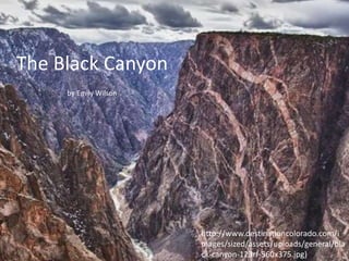
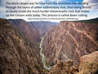
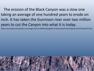
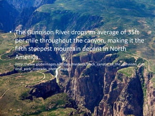
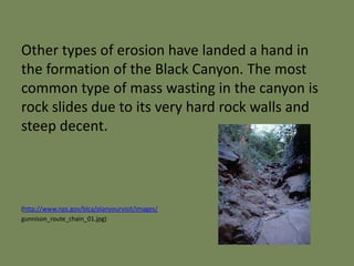
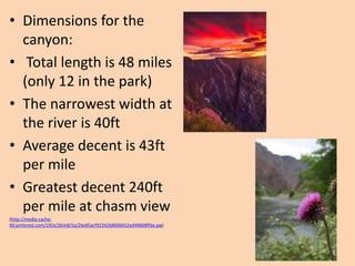
The Black Canyon
by Emily Wilson
http://www.destinationcolorado.com/i
mages/sized/assets/uploads/general/bla
ck-canyon-123rf-560x375.jpg)
• The processes that ended up forming the
Black Canyon started way back in the
Precambrian period when the metamorphic
rocks that the canyon mainly consist of were
formed. Then during the Tertiary period a
large uplift occurred redirecting the course of
the Gunnison river onto its current track.
(http://2.bp.blogspot.com/-go29qCBpBaI/T-eCwOE1ZdI/AAAAAAAAB_c/DKu8-R_kUQg/s1600/DSC00394.jpg)
The black canyon was formed from the Gunnison river eroding
through the layers of softer sedimentary rock, then being forced
to slowly erode the much harder metamorphic rock that makes
up the canyon walls today. This process is called down cutting.
(http://farm8.staticflickr.com/7026/6624818183_5ff0f43869.jpg)
The erosion of the Black Canyon was a slow one
taking an average of one hundred years to erode on
inch. It has taken the Gunnison river over two million
years to cut the Canyon into what it is today.
(https://encrypted-tbn3.gstatic.com/images?q=tbn:ANd9GcQptagWeK-b-QuhwavqutPY3qr1DPg5Ub-da1VR7tKzyQUT57oy)
• The Gunnison River drops an average of 35ft
per mile throughout the canyon, making it the
fifth steepest mountain decent in North
America.
• (http://www.globeimages.net/data/media/5/black_canyon_of_the_gunnison_nati
onal_park_colorado_photo_us.jpg)
Other types of erosion have landed a hand in
the formation of the Black Canyon. The most
common type of mass wasting in the canyon is
rock slides due to its very hard rock walls and
steep decent.
(http://www.nps.gov/blca/planyourvisit/images/
gunnison_route_chain_01.jpg)
The Painted Wall is the highest cliff in Colorado.
From river to rim it stands 2250 feet and is 1000
feet taller than the Empire State Building.
(http://www.nps.gov/blca/naturescience/images/pwall_comparison_2.jpg)
• Dimensions for the
canyon:
• Total length is 48 miles
(only 12 in the park)
• The narrowest width at
the river is 40ft
• Average decent is 43ft
per mile
• Greatest decent 240ft
per mile at chasm view
(http://media-cache-
lt0.pinterest.com/192x/26/e8/5a/26e85acf9234268006652ad488d8ffda.jpg)
Black canyon geo project

Black canyon geo project

  • 1.
    The Black Canyon byEmily Wilson http://www.destinationcolorado.com/i mages/sized/assets/uploads/general/bla ck-canyon-123rf-560x375.jpg)
  • 2.
    • The processesthat ended up forming the Black Canyon started way back in the Precambrian period when the metamorphic rocks that the canyon mainly consist of were formed. Then during the Tertiary period a large uplift occurred redirecting the course of the Gunnison river onto its current track. (http://2.bp.blogspot.com/-go29qCBpBaI/T-eCwOE1ZdI/AAAAAAAAB_c/DKu8-R_kUQg/s1600/DSC00394.jpg)
  • 3.
    The black canyonwas formed from the Gunnison river eroding through the layers of softer sedimentary rock, then being forced to slowly erode the much harder metamorphic rock that makes up the canyon walls today. This process is called down cutting. (http://farm8.staticflickr.com/7026/6624818183_5ff0f43869.jpg)
  • 4.
    The erosion ofthe Black Canyon was a slow one taking an average of one hundred years to erode on inch. It has taken the Gunnison river over two million years to cut the Canyon into what it is today. (https://encrypted-tbn3.gstatic.com/images?q=tbn:ANd9GcQptagWeK-b-QuhwavqutPY3qr1DPg5Ub-da1VR7tKzyQUT57oy)
  • 5.
    • The GunnisonRiver drops an average of 35ft per mile throughout the canyon, making it the fifth steepest mountain decent in North America. • (http://www.globeimages.net/data/media/5/black_canyon_of_the_gunnison_nati onal_park_colorado_photo_us.jpg)
  • 6.
    Other types oferosion have landed a hand in the formation of the Black Canyon. The most common type of mass wasting in the canyon is rock slides due to its very hard rock walls and steep decent. (http://www.nps.gov/blca/planyourvisit/images/ gunnison_route_chain_01.jpg)
  • 7.
    The Painted Wallis the highest cliff in Colorado. From river to rim it stands 2250 feet and is 1000 feet taller than the Empire State Building. (http://www.nps.gov/blca/naturescience/images/pwall_comparison_2.jpg)
  • 8.
    • Dimensions forthe canyon: • Total length is 48 miles (only 12 in the park) • The narrowest width at the river is 40ft • Average decent is 43ft per mile • Greatest decent 240ft per mile at chasm view (http://media-cache- lt0.pinterest.com/192x/26/e8/5a/26e85acf9234268006652ad488d8ffda.jpg)