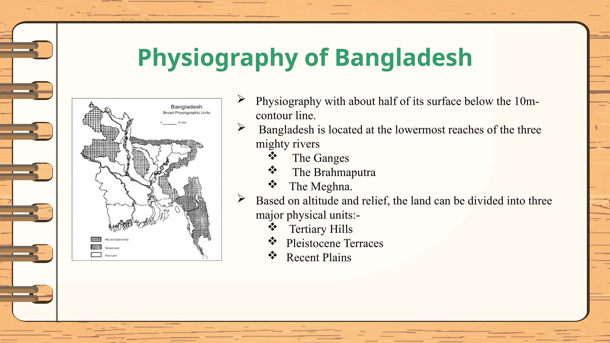
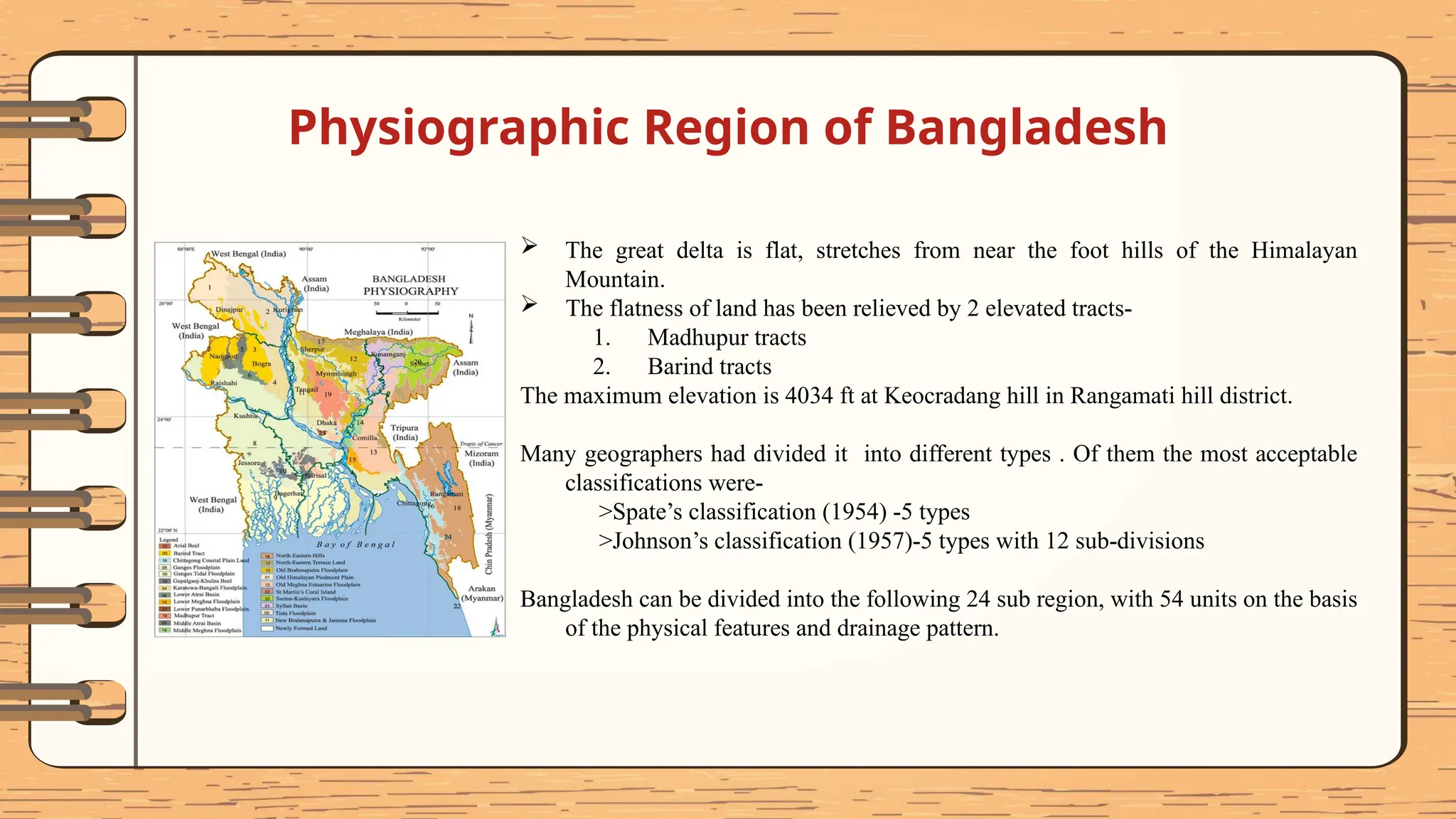
Physiography of
Bangladesh
Presented by
Tanjia Jahan Moni 2019135155
Name Registration No.
Md. Mominul Islam 2019135158
Tasnia Anjum Tajin 2019135159
Tanha Tabassum Hridi 2019135160
Samia Ahmed 2019135166
Nur E Sarah Khandaker 2019135171
Bangladesh is located at the lowermost reaches of the three mighty
rivers, the Ganges, the Brahmaputra and the Meghna. Bangladesh's
alluvial soil is highly fertile, but vulnerable to flood and drought.
Absolute Location: Bangladesh is extends from 20'34N to 26'38N
latitude and from 88'01E to 92'41E longitude.
Relative Location: The Indian States of West Bengal, Assam,
Meghalaya and Tripura border Bangladesh in the west, north and east
respectively. Myanmar forms the southern part of the eastern frontier.
South of the Bay of Bengal.
Size: 147,610 km2(56,990 sq. mi).
Introduction
What is Physiography?
Huxley first used the term "physiography" in the field of geography in 1869 to refer to the study or description of
"natural phenomena in general." However, over time, it came to mean "a description of the surface features of the
earth, as bodies of air, water, and land," with an emphasis on mode of origin. As a result, it came to be used to refer to
Geology, Pedology, Meteorology, and Oceanography.
Physiography is basically the study of the physical characteristics of the earth's surface.
“Physiography is the science which treats of the earth’s exterior physical features, climate, life etc. and of the physical
movements or changes on the earth’s surface, as the current of the atmosphere and ocean the secular variations in
heat, moisture, magnetism etc.”
--Century Dictionary & Cyclopedia
Physiography of Bangladesh
 Physiography with about half of its surface below the 10m-
contour line.
 Bangladesh is located at the lowermost reaches of the three
mighty rivers
 The Ganges
 The Brahmaputra
 The Meghna.
 Based on altitude and relief, the land can be divided into three
major physical units:-
 Tertiary Hills
 Pleistocene Terraces
 Recent Plains
Physiographic Region of Bangladesh
 The great delta is flat, stretches from near the foot hills of the Himalayan
Mountain.
 The flatness of land has been relieved by 2 elevated tracts-
1. Madhupur tracts
2. Barind tracts
The maximum elevation is 4034 ft at Keocradang hill in Rangamati hill district.
Many geographers had divided it into different types . Of them the most acceptable
classifications were-
>Spate’s classification (1954) -5 types
>Johnson’s classification (1957)-5 types with 12 sub-divisions
Bangladesh can be divided into the following 24 sub region, with 54 units on the basis
of the physical features and drainage pattern.
1. Himalayan Piedmont Plains
Himalayan Piedmont plains
Location: Panchagarh and Thakurgaon district and North Eastern
part of Dinajpur district .
Characteristics:
 Old Himalayan piedmont plain the gently sloping land at the
foot of hills.
 Formed with colluvial and alluvial sediments deposited by
RIVERS or STREAMS.
 This region is covered by Piedmont sands and gravels .
 The predominant soil texture is sandy loam and sandy silt.
 The soils are in general fertile and are rich in potassium and
phosphorus.
 The rivers are slightly dome shaped
2. Tista Floodplain
Location: Nilphamari, Rangpur, Lalmonirhat, Kurigram and
Gaibandha districts
Characteristics:
 Soil texture is sandy loam.
 The soils are in general fertile and are rich in potassium and
phosphorus.
 Most of the land is shallowly flooded during monsoons.
 Non-calcareous brown floodplain and grey floodplain soil.
 Fertility level is low to medium.
 Soils, in general, have good moisture holding capacity.
 Organic matter content is medium.
3. Barind Tract
The Barind Tract covers most parts of the greater Dinajpur, Rangpur,
Pabna, Rajshahi, Bogra, Joypurhat and naogaon districts of Rajshahi
division.
Characteristics:
 Covered mostly by Tertiary and Quaternary sediments and Recent
Alluvium.
 As this region is generally free from floodwater, rainwater is the
only major source of groundwater recharge.
 Grey terrace soil.
 Lime nodules and pisolitic ferruginous concretions occur throughout
the soil.
 Soil pH varies between 6.0 and 7.5.
4. Little Jamuna Floodplain
Location: Dinajpur, Naogaon, Phulbari, Joypurhat, Panchbibi,
Mahadebpur, Adamdighi, Patnitola, Badalgachhi.
Characteristics:
 Its valley is very narrow.
 Soil color is greyish sandy-silt and the reddish clays appear.
 The valley is terminates in the bills.
5. Middle Atrai Basin
Location: Chirribandar to Mahadevpur
Characteristics:
 The relief is that of low ridges and shallow basins.
 Soil texture is sandy soil.
 The ridges usually remain above flood level,
but the lower areas are flash flood.
 The river is entrenched.
6. Lower Purnabhaba Floodplain
Location: Weastern part of Neogan and Northern part of
Nowabganj District.
Size: 129 squre km area
Rivers: Mahananda, Purnabhaba.
Characteristics:
 Basins and Bils separated by low floodplain ridges occupy the
whole area.
 Land type: Medium low land Low land
 Dark grey, mottled red, very strongly acidic soil.
 Soil color: Soils are dark grey, mottled red.
 Very strongly acidic (pH. <5.0), heavy clay.
 Organic matter content is about 2-5% the cultivated
layer and 1-2% in the subsoil.
7. Lower Atrai Basin
Location: Most of the region lies in Naogaon and Natore Districts
and some of the area of Rajshahi, Bogra and Sirajgonj District.
Size: The region covers about 851 km2 area.
Rivers: Hurasagar.
Charecteristics
 The western part of the basins flood deeply and often quickly.
 The eastern part of the basin hasmore ridges
 Smooth, low-lying , basin land occupies most of the region
 Relief is locally irregular near river channels
 Dark grey, heavy, acidic clays are predominate in this smooth
low-lying basin land
 Soil are predominating by dark grey
 The landscape north of the Atrai river is mainly smooth
Location: Dinajpur district, Bholahat Upazila, Gomastapur
Upazila, Chapai-Nawabganj district.
Characteristics:
 Floodplain lies between the Barind and the Ganges floodplain.
 The river is slightly entrenched.
 This floodplain varies in breadth.
8. Lower Mahananda Floodplain
9. Ganges Floodplain
 Active Ganges Floodplain (3,334 sq km) this region occupies
unstable alluvial land within and adjoining ganges river.
 It has irregular relief of broad and narrow ridges and depressions
interrupted by cut-off channels and active channels.
 The area has complex mixtures of calcareous sandy, silty and clayey
alluvium.
 The general soil types, predominantly include, calcareous, alluvium
and calcareous brown floodplain soils.
 The region includes areas of “Diaras and Chars” and “North Ganges
old floodplain”
10. Brahmaputra & Jamuna Floodplain
 Their main tributary TISTA.
 The Brahmaputra-Jamuna drains the northern and eastern slopes of
the HIMALAYAS, and has a catchment area of 5,83,000 sq km.
 The right-bank tributaries are the Tista and Atrai-Gur rivers and the
two left-bank distributaries are the abandoned course of the
Brahmaputra now known as the Old Brahmaputra and the
DHALESHWARI.
 They Have 3 sub zone-
1. Bangali-korotoya Floodplain
2. Diaras & Chars
3. Jamuna and Kaliganga Floodplain
11. Old Brahmaputra Floodplain
 The Old Brahmaputra River is a distributary of the Brahmaputra River in
north-central Bangladesh.
 Historically the main stem of the Brahmaputra, the larger river's primary
outflow was redirected via the Jamuna River after the 1762 Arakan
earthquake.
 The river branches off from the Brahmaputra in Jamalpur District and
flows southeasterly for approximately 200 km (120 mi) before meeting the
Meghna River in Kishoreganj District.
 The region includes areas of High ridge, Floodplain complex, Western
plain, Northern plain, southern plain and Eastern plain.
12. Susang Hills & Piedmont
(a) Susang hill
 This Region extends in a thin line of some 161 km. length from the north
of Jamalpur to North of Sunamganj District.
 It includes the hillocks at the base of the Meghalaya plateau.
 In the Susang Hills of Bangladesh only Dupi Tila and Dihing sequences
are exposed. Kaolinitic white clay deposits of Bijoypur (Netrokona
district) occur in Dupi Tila Formation in lenses alternating with
sandstones.
(b) Piedmont Plains
 This sub region covers most of Nalitabari, Halughat and Kalmakanda and
part of Durgapur Upazilla.
 Most of the area is only very shallowly flooded in the monsoos snd too hat
too due to field bunds to retain the rain water.
Susang Durgapur, Netrokona
13. Madhupur Tract
Large upland area in the central part of Bangladesh. The southern
part known as Bhawal Garh & the northern part as Madhupur Garh.
Present form is of Pleistocene age, origin may be in the late
Miocene,Total extent 4,244 sq km.
 Location – Dhaka, Gazipur, Narsingdi, Narayanganj, Tangail,
Mymensingh and Kishoreganj
 Average temperatures vary from 28'C to 32'C in summer,
 falling to 20'C in winter, with extreme lows of 10’C.
 Rainfall ranges between 1,000 mm and 1,500 mm annually.
 Soils are nutrient poor and acidic.
 Red or brown in colour.
14. Haor Basin
 In the north eastern part of Bangladesh
 Saucer shaped shallow depression
 Parts of the Sunamganj, Moulvibazar and Habiganj districts, and
stretches as far as the Kishorenganj and Netrokona districts of
Bangladesh.
 Estimated to stretch over an area of between 4450 square kilometers
and 2.5 million hectares.
 Surrounded by the mountain ranges of India, with Meghalaya to the
north, Tripura and Mizoram to the south, and Manipur and Assam to
the east.
 Fishing is the main income-generating activity
 47 major haors and some 6,300 beels of varying size
15. Northern and Eastern Piedmont Plains
 Sloping piedmont plains which border the northern and eastern hills
 Comprise coalesced alluvial fans,
 Have silty or sandy deposits near to the hills, grading into clays in
the basin adjoining the neighbouring floodplains.
 The whole area is subject to flash floods during the rainy season.
 Nalitabari (Sherpur), Tahirpur, Bishwamvarpur, Dowarabazar,
Companiganj (Sylhet), Gowainghat, Madhabpur, Habiganj Sadar,
Chunarughat, Sreemangal, Kamalganj and Kulaura.
 Two main kinds of topography –
a) Low Hill Ranges ,
b) High Hill or Mountain Ranges
16. Low Hill Ranges
 Occur between and outside the high hill ranges
 Unconsolidated sandstone and shale.
 Summits are <300m above MSL.
 In the Sylhet region, there are four main hillocks in the northern
zone
 Six hill ranges project into the south of Sylhet district from the
Indian state of Tripura.
 In the Chittagong region, this unit includes the Sitakunda and
Mara Tong ranges and the complex of hills to the south and east
of Ramgarh, including the eastern part of the Middle Feni river
valley. The Sitakunda range has a 32-km long ridge in the middle,
which reaches 352m at Sitakunda peak.
17. Meghna Floodplain
Location: Chandpur, Lakshmipur and Noakhali districts,
Chittagong,Feni, Barisal, Patuakhali and Barguna districts,
Kishoreganj, Habiganj, Brahmanbaria, Comilla.
Characteristics:
 The region's soils are loamy and grey on the ridges, and
clayey and grey to dark grey in the basins.
 Fertility is medium
 Topsoil is extremely acidic
 Sub soil slightly acidic to slightly alkaline
18. Tippera Surface
Location: Noakhali,(Nabinagar ,South to Maijdi).
Characteristics:
 It has a rectangular drainage pattern.
 Soil is slightly acidic
 The relief is almost level broad ridges and basins.
 A long depression (from Kachua to Maijdi marks an area
of deeper flooding.
 There are extensive man-made raised land.
 It is composed of Pleistocene sediments , sandy clays etc.
19. Moribund Delta
Location: Jessore, Kushtia, Faridpur etc.
Characteristics:
 This region is conventionally classed as high plain.
 Rivers are choked with sand and unable to carry much water except
when the ganges is in high flood.
 Offshore are Islands are its main characteristics.
 Regular flooding and formation of Chars are offshore islands are its
characteristics.
 The main distributary of the Ganges of this area is called “Gorai”.
 The north-west and south-west of this region is higher than the
rest.
20. Central Delta Basins
Location: This basin is situated at the junction of Moribund,Immature and
Mature delta.
Characteristics:
 Locally this region is called “Faridpur Bil Area”.
 This area is low-lying.
 The zone where the rise of the tide has led to rapid deposition of the
silt (Strickland,1940).-There are extensive shoals.
 There is a large very low estuarine area, this is because of two causes-
1. Insufficient deposition by Ganges rivers.
2.Subsidence.
21. Immature Delta
Location: The immature delta is on the south of the moribund delta and
mainly consists of sea beach and tidally influenced lands. The Sundarbans
belongs to this region.
Characteristics:
 Subsidence is high in the immature delta.
 The maximum elevation of the Immature delta is 0.91 m above sea
level
22. Mature Delta
Location: It lies between the Moribund and the Active parts of the delta and comprises
the areas in the districts of Faridpur and northern part of Barisal, Khunla and Satkhira
districts of Bangladesh.
Characteristics:
 The Mature Delta is composed of four floodplains, the Old Ganges floodplain, the
Padma-Madhumati floodplain, the non-saline tidal floodplain and the saline tidal
floodplain.
 Areas vary in their relief and tidal affects.
 It comprises the saline, non-forested areas..
 The area is mostly covered by tidal deltaic deposits.
 The land is suitable for cultivation but salinity intrusion is a major threat for
agricultural cultivation and terrestrial ecosystems in summer.
23. Active Delta
Location: The active delta is situated mainly at the estuary of the Meghna
river entering the bay of bengal (Bhola, Hatiya, Sandwip, Rajbari,
Faridpur, Madaripur, Shariatpur, Gopalgonj, Pirojpur etc).
Characteristics:
 Regular flooding and formation of chars are its characteristics.
 offshore islands.
 The non-salty estuary, tidal, and island char-lands serve as a type of
transitional area to the active delta.
24. Chittagong Sub-Region
Location: It lies south of the Feni River containing many lakes, islands, mountain
ranges and forests. It can be further sub-divided into 10 physiographic areas
characterizing the coastal plains, islands and deltas, the central valley, the western hills,
Bakkhali river valley, Southern beach plain, jinjira islets and the mountain ranges to
the east.
Characteristics:
 This region suffers from continuous erosion and accretion. The valleys are curved
and almost isolated hillocks are common.
 Average land elevation is below 1.5 m.
 These areas endure severe salinity intrusion and tidal flooding.
 The region is characterized by a huge network of trellis and dendritic drainage
consisting of some major rivers draining into the bay of Bengal.
Conclusion
Bangladesh is a country of physiographic variations. It is enriched with the beauty of hills,
fertile land, rivers and streams and so on. We see a lot of verities in this small area. Anyone can
understand after knowing about the physiographic regions of Bangladesh that the nature has
grown here largely depending on the rivers. The enormous deposition of the larger rivers has
been brought out into formation of the largest Delta Bay of the world. But remarkable changes
in the natural units are going under threatening condition day by day due to climatic and man-
made occurrences. The safety of the nature must be preserved for none but our own benefit.
Thank You

Bangladesh Physiography final draft.pptx

  • 1.
  • 2.
    Presented by Tanjia JahanMoni 2019135155 Name Registration No. Md. Mominul Islam 2019135158 Tasnia Anjum Tajin 2019135159 Tanha Tabassum Hridi 2019135160 Samia Ahmed 2019135166 Nur E Sarah Khandaker 2019135171
  • 3.
    Bangladesh is locatedat the lowermost reaches of the three mighty rivers, the Ganges, the Brahmaputra and the Meghna. Bangladesh's alluvial soil is highly fertile, but vulnerable to flood and drought. Absolute Location: Bangladesh is extends from 20'34N to 26'38N latitude and from 88'01E to 92'41E longitude. Relative Location: The Indian States of West Bengal, Assam, Meghalaya and Tripura border Bangladesh in the west, north and east respectively. Myanmar forms the southern part of the eastern frontier. South of the Bay of Bengal. Size: 147,610 km2(56,990 sq. mi). Introduction
  • 4.
    What is Physiography? Huxleyfirst used the term "physiography" in the field of geography in 1869 to refer to the study or description of "natural phenomena in general." However, over time, it came to mean "a description of the surface features of the earth, as bodies of air, water, and land," with an emphasis on mode of origin. As a result, it came to be used to refer to Geology, Pedology, Meteorology, and Oceanography. Physiography is basically the study of the physical characteristics of the earth's surface. “Physiography is the science which treats of the earth’s exterior physical features, climate, life etc. and of the physical movements or changes on the earth’s surface, as the current of the atmosphere and ocean the secular variations in heat, moisture, magnetism etc.” --Century Dictionary & Cyclopedia
  • 5.
    Physiography of Bangladesh Physiography with about half of its surface below the 10m- contour line.  Bangladesh is located at the lowermost reaches of the three mighty rivers  The Ganges  The Brahmaputra  The Meghna.  Based on altitude and relief, the land can be divided into three major physical units:-  Tertiary Hills  Pleistocene Terraces  Recent Plains
  • 6.
    Physiographic Region ofBangladesh  The great delta is flat, stretches from near the foot hills of the Himalayan Mountain.  The flatness of land has been relieved by 2 elevated tracts- 1. Madhupur tracts 2. Barind tracts The maximum elevation is 4034 ft at Keocradang hill in Rangamati hill district. Many geographers had divided it into different types . Of them the most acceptable classifications were- >Spate’s classification (1954) -5 types >Johnson’s classification (1957)-5 types with 12 sub-divisions Bangladesh can be divided into the following 24 sub region, with 54 units on the basis of the physical features and drainage pattern.
  • 7.
    1. Himalayan PiedmontPlains Himalayan Piedmont plains Location: Panchagarh and Thakurgaon district and North Eastern part of Dinajpur district . Characteristics:  Old Himalayan piedmont plain the gently sloping land at the foot of hills.  Formed with colluvial and alluvial sediments deposited by RIVERS or STREAMS.  This region is covered by Piedmont sands and gravels .  The predominant soil texture is sandy loam and sandy silt.  The soils are in general fertile and are rich in potassium and phosphorus.  The rivers are slightly dome shaped
  • 8.
    2. Tista Floodplain Location:Nilphamari, Rangpur, Lalmonirhat, Kurigram and Gaibandha districts Characteristics:  Soil texture is sandy loam.  The soils are in general fertile and are rich in potassium and phosphorus.  Most of the land is shallowly flooded during monsoons.  Non-calcareous brown floodplain and grey floodplain soil.  Fertility level is low to medium.  Soils, in general, have good moisture holding capacity.  Organic matter content is medium.
  • 9.
    3. Barind Tract TheBarind Tract covers most parts of the greater Dinajpur, Rangpur, Pabna, Rajshahi, Bogra, Joypurhat and naogaon districts of Rajshahi division. Characteristics:  Covered mostly by Tertiary and Quaternary sediments and Recent Alluvium.  As this region is generally free from floodwater, rainwater is the only major source of groundwater recharge.  Grey terrace soil.  Lime nodules and pisolitic ferruginous concretions occur throughout the soil.  Soil pH varies between 6.0 and 7.5.
  • 10.
    4. Little JamunaFloodplain Location: Dinajpur, Naogaon, Phulbari, Joypurhat, Panchbibi, Mahadebpur, Adamdighi, Patnitola, Badalgachhi. Characteristics:  Its valley is very narrow.  Soil color is greyish sandy-silt and the reddish clays appear.  The valley is terminates in the bills.
  • 11.
    5. Middle AtraiBasin Location: Chirribandar to Mahadevpur Characteristics:  The relief is that of low ridges and shallow basins.  Soil texture is sandy soil.  The ridges usually remain above flood level, but the lower areas are flash flood.  The river is entrenched.
  • 12.
    6. Lower PurnabhabaFloodplain Location: Weastern part of Neogan and Northern part of Nowabganj District. Size: 129 squre km area Rivers: Mahananda, Purnabhaba. Characteristics:  Basins and Bils separated by low floodplain ridges occupy the whole area.  Land type: Medium low land Low land  Dark grey, mottled red, very strongly acidic soil.  Soil color: Soils are dark grey, mottled red.  Very strongly acidic (pH. <5.0), heavy clay.  Organic matter content is about 2-5% the cultivated layer and 1-2% in the subsoil.
  • 13.
    7. Lower AtraiBasin Location: Most of the region lies in Naogaon and Natore Districts and some of the area of Rajshahi, Bogra and Sirajgonj District. Size: The region covers about 851 km2 area. Rivers: Hurasagar. Charecteristics  The western part of the basins flood deeply and often quickly.  The eastern part of the basin hasmore ridges  Smooth, low-lying , basin land occupies most of the region  Relief is locally irregular near river channels  Dark grey, heavy, acidic clays are predominate in this smooth low-lying basin land  Soil are predominating by dark grey  The landscape north of the Atrai river is mainly smooth
  • 14.
    Location: Dinajpur district,Bholahat Upazila, Gomastapur Upazila, Chapai-Nawabganj district. Characteristics:  Floodplain lies between the Barind and the Ganges floodplain.  The river is slightly entrenched.  This floodplain varies in breadth. 8. Lower Mahananda Floodplain
  • 15.
    9. Ganges Floodplain Active Ganges Floodplain (3,334 sq km) this region occupies unstable alluvial land within and adjoining ganges river.  It has irregular relief of broad and narrow ridges and depressions interrupted by cut-off channels and active channels.  The area has complex mixtures of calcareous sandy, silty and clayey alluvium.  The general soil types, predominantly include, calcareous, alluvium and calcareous brown floodplain soils.  The region includes areas of “Diaras and Chars” and “North Ganges old floodplain”
  • 16.
    10. Brahmaputra &Jamuna Floodplain  Their main tributary TISTA.  The Brahmaputra-Jamuna drains the northern and eastern slopes of the HIMALAYAS, and has a catchment area of 5,83,000 sq km.  The right-bank tributaries are the Tista and Atrai-Gur rivers and the two left-bank distributaries are the abandoned course of the Brahmaputra now known as the Old Brahmaputra and the DHALESHWARI.  They Have 3 sub zone- 1. Bangali-korotoya Floodplain 2. Diaras & Chars 3. Jamuna and Kaliganga Floodplain
  • 17.
    11. Old BrahmaputraFloodplain  The Old Brahmaputra River is a distributary of the Brahmaputra River in north-central Bangladesh.  Historically the main stem of the Brahmaputra, the larger river's primary outflow was redirected via the Jamuna River after the 1762 Arakan earthquake.  The river branches off from the Brahmaputra in Jamalpur District and flows southeasterly for approximately 200 km (120 mi) before meeting the Meghna River in Kishoreganj District.  The region includes areas of High ridge, Floodplain complex, Western plain, Northern plain, southern plain and Eastern plain.
  • 18.
    12. Susang Hills& Piedmont (a) Susang hill  This Region extends in a thin line of some 161 km. length from the north of Jamalpur to North of Sunamganj District.  It includes the hillocks at the base of the Meghalaya plateau.  In the Susang Hills of Bangladesh only Dupi Tila and Dihing sequences are exposed. Kaolinitic white clay deposits of Bijoypur (Netrokona district) occur in Dupi Tila Formation in lenses alternating with sandstones. (b) Piedmont Plains  This sub region covers most of Nalitabari, Halughat and Kalmakanda and part of Durgapur Upazilla.  Most of the area is only very shallowly flooded in the monsoos snd too hat too due to field bunds to retain the rain water. Susang Durgapur, Netrokona
  • 19.
    13. Madhupur Tract Largeupland area in the central part of Bangladesh. The southern part known as Bhawal Garh & the northern part as Madhupur Garh. Present form is of Pleistocene age, origin may be in the late Miocene,Total extent 4,244 sq km.  Location – Dhaka, Gazipur, Narsingdi, Narayanganj, Tangail, Mymensingh and Kishoreganj  Average temperatures vary from 28'C to 32'C in summer,  falling to 20'C in winter, with extreme lows of 10’C.  Rainfall ranges between 1,000 mm and 1,500 mm annually.  Soils are nutrient poor and acidic.  Red or brown in colour.
  • 20.
    14. Haor Basin In the north eastern part of Bangladesh  Saucer shaped shallow depression  Parts of the Sunamganj, Moulvibazar and Habiganj districts, and stretches as far as the Kishorenganj and Netrokona districts of Bangladesh.  Estimated to stretch over an area of between 4450 square kilometers and 2.5 million hectares.  Surrounded by the mountain ranges of India, with Meghalaya to the north, Tripura and Mizoram to the south, and Manipur and Assam to the east.  Fishing is the main income-generating activity  47 major haors and some 6,300 beels of varying size
  • 21.
    15. Northern andEastern Piedmont Plains  Sloping piedmont plains which border the northern and eastern hills  Comprise coalesced alluvial fans,  Have silty or sandy deposits near to the hills, grading into clays in the basin adjoining the neighbouring floodplains.  The whole area is subject to flash floods during the rainy season.  Nalitabari (Sherpur), Tahirpur, Bishwamvarpur, Dowarabazar, Companiganj (Sylhet), Gowainghat, Madhabpur, Habiganj Sadar, Chunarughat, Sreemangal, Kamalganj and Kulaura.  Two main kinds of topography – a) Low Hill Ranges , b) High Hill or Mountain Ranges
  • 22.
    16. Low HillRanges  Occur between and outside the high hill ranges  Unconsolidated sandstone and shale.  Summits are <300m above MSL.  In the Sylhet region, there are four main hillocks in the northern zone  Six hill ranges project into the south of Sylhet district from the Indian state of Tripura.  In the Chittagong region, this unit includes the Sitakunda and Mara Tong ranges and the complex of hills to the south and east of Ramgarh, including the eastern part of the Middle Feni river valley. The Sitakunda range has a 32-km long ridge in the middle, which reaches 352m at Sitakunda peak.
  • 23.
    17. Meghna Floodplain Location:Chandpur, Lakshmipur and Noakhali districts, Chittagong,Feni, Barisal, Patuakhali and Barguna districts, Kishoreganj, Habiganj, Brahmanbaria, Comilla. Characteristics:  The region's soils are loamy and grey on the ridges, and clayey and grey to dark grey in the basins.  Fertility is medium  Topsoil is extremely acidic  Sub soil slightly acidic to slightly alkaline
  • 24.
    18. Tippera Surface Location:Noakhali,(Nabinagar ,South to Maijdi). Characteristics:  It has a rectangular drainage pattern.  Soil is slightly acidic  The relief is almost level broad ridges and basins.  A long depression (from Kachua to Maijdi marks an area of deeper flooding.  There are extensive man-made raised land.  It is composed of Pleistocene sediments , sandy clays etc.
  • 25.
    19. Moribund Delta Location:Jessore, Kushtia, Faridpur etc. Characteristics:  This region is conventionally classed as high plain.  Rivers are choked with sand and unable to carry much water except when the ganges is in high flood.  Offshore are Islands are its main characteristics.  Regular flooding and formation of Chars are offshore islands are its characteristics.  The main distributary of the Ganges of this area is called “Gorai”.  The north-west and south-west of this region is higher than the rest.
  • 26.
    20. Central DeltaBasins Location: This basin is situated at the junction of Moribund,Immature and Mature delta. Characteristics:  Locally this region is called “Faridpur Bil Area”.  This area is low-lying.  The zone where the rise of the tide has led to rapid deposition of the silt (Strickland,1940).-There are extensive shoals.  There is a large very low estuarine area, this is because of two causes- 1. Insufficient deposition by Ganges rivers. 2.Subsidence.
  • 27.
    21. Immature Delta Location:The immature delta is on the south of the moribund delta and mainly consists of sea beach and tidally influenced lands. The Sundarbans belongs to this region. Characteristics:  Subsidence is high in the immature delta.  The maximum elevation of the Immature delta is 0.91 m above sea level
  • 28.
    22. Mature Delta Location:It lies between the Moribund and the Active parts of the delta and comprises the areas in the districts of Faridpur and northern part of Barisal, Khunla and Satkhira districts of Bangladesh. Characteristics:  The Mature Delta is composed of four floodplains, the Old Ganges floodplain, the Padma-Madhumati floodplain, the non-saline tidal floodplain and the saline tidal floodplain.  Areas vary in their relief and tidal affects.  It comprises the saline, non-forested areas..  The area is mostly covered by tidal deltaic deposits.  The land is suitable for cultivation but salinity intrusion is a major threat for agricultural cultivation and terrestrial ecosystems in summer.
  • 29.
    23. Active Delta Location:The active delta is situated mainly at the estuary of the Meghna river entering the bay of bengal (Bhola, Hatiya, Sandwip, Rajbari, Faridpur, Madaripur, Shariatpur, Gopalgonj, Pirojpur etc). Characteristics:  Regular flooding and formation of chars are its characteristics.  offshore islands.  The non-salty estuary, tidal, and island char-lands serve as a type of transitional area to the active delta.
  • 30.
    24. Chittagong Sub-Region Location:It lies south of the Feni River containing many lakes, islands, mountain ranges and forests. It can be further sub-divided into 10 physiographic areas characterizing the coastal plains, islands and deltas, the central valley, the western hills, Bakkhali river valley, Southern beach plain, jinjira islets and the mountain ranges to the east. Characteristics:  This region suffers from continuous erosion and accretion. The valleys are curved and almost isolated hillocks are common.  Average land elevation is below 1.5 m.  These areas endure severe salinity intrusion and tidal flooding.  The region is characterized by a huge network of trellis and dendritic drainage consisting of some major rivers draining into the bay of Bengal.
  • 31.
    Conclusion Bangladesh is acountry of physiographic variations. It is enriched with the beauty of hills, fertile land, rivers and streams and so on. We see a lot of verities in this small area. Anyone can understand after knowing about the physiographic regions of Bangladesh that the nature has grown here largely depending on the rivers. The enormous deposition of the larger rivers has been brought out into formation of the largest Delta Bay of the world. But remarkable changes in the natural units are going under threatening condition day by day due to climatic and man- made occurrences. The safety of the nature must be preserved for none but our own benefit.
  • 32.