Decoding Kotlin - Your guide to solving the mysterious in Kotlin.pptx
audley-charles1972.pdf
1. Palaeogeography, Palaeoclimatology, Palaeoecology
Elsevier Publishing Company, Amsterdam - Printed in The Netherlands
PALAEOGEOGRAPHICAL SIGNIFICANCE OF SOM E ASPECTS OF
PALAEOGENE AND EARLY NEOGENE STRATIGRAPHY AND
TECTONICS OF THE TIMOR SEA REGION
M. G. AUDLEY-CHARLES AND D. J. CARTER
Department of Geology, Imperial College of Science and Technology, London (Great Britain)
(Received October 18, 1971)
ABSTRACT
Audley-Charles, M. G. and Carter, D. J., 1972. Palaeogeographical significance of some aspects
of Palaeogene and Early Neogene stratigraphy and tectonics of the Timor Sea region.
Palaeogeogr., Palaeoclimatol., Palaeoecol., 11: 247-264.
New evidence from Timor and the Ashmore Reef offshore well suggest that the Palaeogene
and Early Neogene geological history of Timor was very different from that of the Sahul Shelf
and northern Australia. Recently published correlations between Timor, Ashmore Reef and
Australia are disputed and another solution is proposed.
Lower Miocene limestones, whose status is critical to the understanding of Timor's
Cenozoic tectonic and stratigraphical history, are shown by unambiguous field evidence to be
autochthonous. This allows a pre-Miocene major orogenic phase in Timor to be confirmed. On
the basis of new stratigraphical evidence a mechanism is proposed to explain the development
of the Lower Miocene autochthonous "fatus", which relates their origin partly to lateral facies
changes in the Lower Miocene and partly to their subsequent mode of erosion by the emplacement
of the Bobonaro olistostrome.
New evidence is given in support of an earlier contention, recently challenged by Veevers
(1969), that a Timor trough separating the Sahul Shelf from Timor has existed since the Early
Eocene.
Utilising recent information from a deep offshore well at Ashmore Reef and recently
published drift rates for the Indian Ocean-Australian plate and palaeomagnetic palaeolatitudes
for Australia a series of palaeogeographical maps for the Timor Sea region have been drawn.
INTRODUCTION
In his recent paper on the palaeogeography of the Timor Sea region Veevers
(1969) challenged the view put forward by one of the authors (Audley-Charles,
1966a) that the geological history of Timor was different from that of northern
Australia during the Cenozoic. Veevers arrived at the conclusion that these regions
were geologically similar during the Cenozoic (up to the Mid-Miocene orogenic
phase), on the basis of his interpretation that the Lower Miocene Cablac Limestone
of Timor is allochthonous, and by omitting any consideration of the Timorean
major orogenic phase that, it has been argued (Audley-Charles, 1968), affected all
Timor and other islands of the Outer Banda Arc during the Maestrichtian-Middle
Eocene interval. The Eocene geology of Timor is (it will be argued here) significantly
different from the Eocene history of the Ashmore Reef-Bonaparte Depression
Palaeogeogr., Palaeoclimatol., Palaeoecol., 11 (1972) 247-264
2. 248 M. G. AUDLEY-CHARLES AND D. J. CARTER
region of the northern Australian shelf as revealed by recent drilling and seismic
surveying (Veevers, 1969; Mollan et al., 1970).
Veevers (1969) also suggested that the Timor Trough, which separates
Timor from the Sahul shelf(see Fig.4, 5, 6) was formed during the Early Pleistocene
and not during the Early Eocene as had been earlier suggested (Audley-Charles,
1966a). Veevers based his suggestion on the same arguments on which he founded
his view of the similarity of the Cenozoic geological histories of the Timor and
Sahul Shelf regions.
The aims of this paper are fivefold: (1) To present the evidence to show that
the overthrusting of the crystalline schists in Timor occurred during an important
orogenic phase that preceded the Middle Miocene orogeny. (2) To provide
evidence to demonstrate that the Lower Miocene Cablac Limestone is autoch-
thonous in Timor and to discuss what this means palaeogeographically. (3) To
propose a mechanism which can account for the origin of the autochthonous "fatus"
of Timor. (4) To discuss the new evidence which indicates the age of the Timor
Trough. (5) To present a series of palaeogeographical maps for the Palaeogene
and Early Neogene based on a stratigraphy and tectonic history very different
from that recently proposed by Veevers (1969).
EVIDENCE FOR THE AUTOCHTHONOUS STATUS OF THE LOWER MIOCENE CABLAC LIME-
STONE
In Portuguese Timor the Cablac Limestone generally rests either directly
on the crystalline schists of the Lolotoi Complex or on a series of eruptive rocks
that separate the Cablac Limestone from the underlying Lolotoi Complex. If the
Lower Miocene Cablac Limestone can be shown to be autochthonous it must
follow that the Lolotoi Complex, which is always allochthonous in Timor, was
overthrust onto Timor during a pre-Miocene orogenic phase.
The Cablac Limestone forms a series of isolated, steep-walled mountains
around whose base collects the scree of fallen Cablac so that as far as we are
aware the actual contact at the base of the formation has never been seen in
Portuguese Timor, Towards the base of the Cablac Limestone a conglomeratic
facies is usually developed with sub-angular to sub-rounded clasts of Cablac and
some clasts of older limestones, quartz and eruptive rocks which are usually more
rounded. Although this rudite locally has a brecciated appearance it was regarded
(Audley-Charles, 1968) as a sedimentary conglomerate.
The brecciated appearance of some of these basal conglomerates in Por-
tuguese Timor, together with the isolated, elevated and klippe-like aspect of these
mountains of Cablac Limestone, have aroused suspicion that they are allocht~aonous
(Grunau, 1957; Lemoine, 1959 and Veevers, 1969). Their brecciated appearance
can however be attributed to the effects of the intense tectonic movements during
the Late Pliocene and less intense movements during the Pleistocene on a hard,
Palaeogeogr., Palaeoclirnatol.,Palaeoecol., 11 (1972)247-264
3. CENOZOIC STRATIGRAPHY AND PALAEOGEOGRAPHY OF TIMOR 249
well-cemented, massive Cablac Limestone which has few bedding planes. The
isolated, elevated position of the Cablac Limestone mountains can be understood
in terms of the Cablac representing patch reefs and related facies which accumulated
on the hard bottom shoals formed by the locally elevated parts of the submarine
floor composed of the Lolotoi Complex and overlying Eocene eruptive rocks and
dense limestones. The topographically lower areas between these Cablac shoals
and reefs may have been unsuitable for the development of reefs, or were perhaps
swept by currents that prevented any important accumulation of sediment on the
sea floor at that time. A further contributing factor to the isolation of the outcrops
of Cablac Limestone was probably the erosional effects (see Fig.7) of the emplace-
ment of the olistostrome (Bobonaro Scaly Clay) that travelled from north to south
across the width of Timor (Audley-Charles, 1968; Boutakoff, 1968) during the
Mid-Miocene orogenic phase. This event followed shortly after the Cablac
Limestone deposition had ceased at the end of the Early Miocene, as Timor sub-
sided to a sufficient depth to allow the olistostrome to be emplaced in the mid-
Middle Miocene. Any soft or unconsolidated Lower and early Middle Miocene
sediment that was present between the Cablac reefs would have been subjected to
intense erosion and probably removed. Soft, white foraminiferal marl of Lower
and early Middle Miocene age has been found locally incorporated into the matrix
of the Bobonaro olistostrome.
The unambiguous evidence for the autochthonous position of the Cablac
Limestone was first described from Indonesian Timor by Tappenbeck (1940) and
later confirmed by De Waard (1957). But De Waard (1954a), like Molengraaff
(1914), 'T Hoen and Van Es (1928) and Brouwer (1942) regarded the Lower
Miocene reefs and off-reef limestones (which are equivalent to the Cablac Lime-
stone of Portuguese Timor) as part of what was called the Fatu Series, which were
thought to be klippen of the uppermost series of nappes. In a later paper De
Waard (1954b) regarded this concept as an oversimplification. One of the authors
(Audley-Charles) visited the localities described by Tappenbeck (1940) and De
Waard (1957) in the Booi region and agrees with their account of the relationship
between the Lower Miocene limestones and the underlying crystalline schists of
the Lolotoi Complex (Fig. 1 and 7). The only important modification suggested to
Tappenbeck's map (1940, fig. 10) is to add the Bobonaro Scaly Clay (Fig. 1).
RELATIONSHIP OF THE LOWER MIOCENE LIMESTONES TO THE CRYSTALLINE SCHISTS
IN THE BOOI REGION OF INDONESIAN TIMOR
The Lower Miocene Cablac Limestone is well developed in the Booi region
(Fig.l, 7) where it forms the usual steep walled mountains. The formation is
best studied in the Noni and Niti (also called Bakaulu) valleys. The Cablac Lime-
stone extends northwards from the Booi region towards Mosu (Fig.2). It forms the
Palaeogeogr., Palaeoclimatol., Palaeoecol., 11 (1972) 247 264
4. 250 M. G. AUDLEY-CHARLES AND D. J. CARTER
AUTOCHTHONOUS ALLOCHTHONOUS
L.MIOCENE- CABLAC LMST ~ M.MIOCENE- BOBONARO SCALYCLAy
~ EOCENE-(MUDSTONESETC.) ~ LOLOTOI COMPLEX-(CRYST,SCHISTS)
Fig.1. Geological map of the Booi region of Indonesian Timor, modified after Tappen-
beck (1940).
mountains Bikmela, Toaf, Naikuku, Naikoin and is exposed in cliffs beside the
upper part of the river Tramnanu.
The critically important exposure is in the valley of the Niti almost 2 km
upstream from its confluence with the Noni (Fig. 1). Here the amphibolites of the
Lolotoi Complex are overlain by a coarse conglomerate composed mainly of
rounded pebble clasts of quartz and rolled corals with clasts of amphibolites and
gneisses which are generally less well rounded, all are held together with a calcite
cement. The amphibolites immediately below the contact with conglomerate are
notably weathered and stained, they pass down into the tough amphibolites and
gneisses typical of the Lolotoi Complex of the Booi region. Immediately overlying
this basal conglomerate is a well-exposed series of marly calcilut'tes in which
nodular cherts pick out the bedding, and chalky limestones with Spiroclypeus sp.,
Miogypsina spp., and Lepidocyclina spp., Operculina sp. and Lithothamniurn sp.
Above these softer rocks are the typical tough, massive limestones, locally coralline,
that make up the bulk of the Cablac Limestone of this region. Tappenbeck (1940,
Palaeogeogr.,Palaeoclimatol.,Palaeoecol.,11 (1972)247-264
5. CENOZOIC STRATIGRAPHY AND PALAEOGEOGRAPHY OF TIMOR
124 125 126"
25l
127"
klo.
CAILACO
mlL
~3~,I~2 ~
L
L
O
L
O
T
Ol +
NorL BES USU ~I
MIOMAF~O " MANDEO
e3 m! ,
+~Tk~NEFONEUT
)Bool~ ~ MOLLO ~ e4
LALA~ ASU m2~
e~ KOLB
ANO m e2
- I
• SEICAL ~O I
m
e4#
~;L5
/ j' OSSULAL% . ~ ' ~ j MATABJA
J ~ A(TANA ~ b b
J " "9~ L 3b=' bC~j
~
• ~B.,R,QU~'~ ~ +
'°i
I
!
P
24 !5" t~6 127'
Fig.2. Map of the present outcrop of the Lolotoi Complex and the Eocene, Oligocene and
Lower Miocene strata of Timor (partly after Tappenbeck, 1940; Van Voorthuysen, 1940; Van
West, 1941; de Waard, 1957). m2 Aliambata Limestone and Bolan facies (Lower Miocene);
ml Cablac limestone (Lower Miocene); b -- Barique Formation (Oligocene); e4 -- Seical
facies (Middle Eocene); e3 -- Wiluba facies and Dartollu Limestone (Middle-Upper Eocene);
e2 Kolbano facies (Lower Upper Eocene); el Mosu facies (Lower Eocene); cross-hatched
areas -- Lolotoi Complex.
p.54) and De Waard (1957, pp.7 and 15) had no doubt that this is a sedimentary
conglomerate and that the contact at the base of the Cablac Limestone is strati-
graphical and not tectonic.
RELATIONSHIPS BETWEEN THE LOWER MIOCENE~ EOCENE AND CRYSTALLINE SCHISTS
OF THE BOOI REGION
Tappenbeck (1940, p.49) described from the confluence of the rivers Sumkiki
and Niti an important section where brecciated amphibolites of the Lolotoi
Complex are overlain by marly limestones containing Asterocyclina. He also
described a section 300 m upstream of regularly-bedded greenish, conglomeratic,
tuffaceous limestones with abundant Discoclylina (Fig.l). The principal clasts of
the conglomerate are volcanic rocks but crystalline schists also contribute. These
Discocyclina-tuffaceous limestones are overlain concordantly by green-violet marly
shales, greywacke and tufts with grey marly limestones which locally contain large
Eocene Foraminifera. These Eocene strata are strongly folded.
From just west of the mouth of the southern tributary of the river Biselo
he described these Eocene strata overlain discordantly by the Lower Miocene reef
Palaeogeogr., Palaeoclimatol., Palaeoecol., I1 (1972)247-264
6. 252 M. G. AUDLEY-CHARLES AND D. J. CARTER
limestones although the contact is apparently not well exposed. The Lower Miocene
Cablac Limestone in the Booi region can thus be seen to rest unconformably on
both the schists of the Lolotoi Complex and on the foraminiferal Eocene strata
that themselves rest unconformably on the metamorphic complex. These funda-
mental relationships were first described by Tappenbeck (1940, pp.49-54 and
Fig.10, 11, 12) and were confirmed by De Waard (1957, pp.14-18 and Fig.5, 6,
8, 9). One of the present authors was also able to confirm these relationships.
However the series of marls, tufts and agglomerates that crop out in the
river Noni between the village of Naikuku and Mt. Naikuku, which Tappenbeck
and De Waard thought were probably overlying the massive Lower Miocene
limestones, are here (Fig.l) regarded as older and below the massive Cablac
Limestones. This view is based on the exposure of the tufts in the river Noni
about 30 m south of the cliffs of Cablac Limestones. Here the tufts dip at 70 ° to
the NNW so that they seem to pass under the cliffs of Cablac. This exposure may
have been revealed recently by erosion as it does not seem to have been noticed
by the earlier workers. This succession of tufts, agglomerates and marls has not
yet yielded a diagnostic microfauna. Some rare lithic rudites and arenites are
present in this sequence, some of the clasts in these rocks are crystalline schists
and were probably derived from the Lolotoi Complex. Both their stratigraphical
position below the Cablac Limestone and their composition suggest that this
succession may be correlated with the fossiliferous tufts, agglomerates and shales
of Eocene age in the Nefoneut (Mosu) region, which is about 12 km NW of
Mt. Bikmela (Fig.1 and 2), described by Van Voorthuysen (1940).
There is an outcrop of well-bedded strata composed of dark grey silty marls,
silty calcilutites and mudstones, that are somewhat sheared and shattered in
places, which appear to be overlying the crystalline schists and amphibolites in the
river Noni about 2 km upstream from the village Naikuku. They were described
as "tonschiefer" by Tappenbeck (1940) who thought they might be Cretaceous
in age. They were recently sampled and a Lower Eocene microfauna has been
identified: Operculina pellatispiroides, Discocyclina sp. indet., and Nummulites
exilis, N. fossulata, etc. These Eocene strata appear to be overlain by the marls
and limestones of the Cablac Limestone but the contact was not found.
SUMMARY OF TIlE STRATIGRAPHICAL RELATIONSHIPS
There are scattered but consistent observations from many parts of Timor
(Fig.2) to show that the metamorphic rocks of the Lolotoi Complex are locally
overlain unconformably by rocks of proven Eocene age and elsewhere by lime-
stones of Lower Miocene age (see Fig.7). Locally the Lower Miocene strata rest
unconformably on the Eocene and transgress onto the metamorphic rocks of the
Lolotoi (Tappenbeck, 1940; De Waard, 1957; Audley-Charles, 1968).
Palaeogeogr.,Palaeoclimatol.,Palaeoecol.,11 (1972)247-264
7. CENOZOIC STRATIGRAPHY AND PALAEOGEOGRAPHY OF TIMOR 253
TECTONIC SIGNIFICANCEOF THIS PALAEOGENEAND EARLY NEOGENESTRATIGRAPHY
The presence of the Lower Eocene fossiliferous strata overlying the crystal-
line schists of the Lolotoi Complex in the Booi region of Indonesian Timor
demonstrates that the Lolotoi Complex was emplaced in Timor either early in the
Lower Eocene or before the Eocene (see Fig.7). Evidence from Portuguese Timor,
it has been argued (Audley-Charles, 1968), indicates that the Lolotoi Complex
was overthrust onto Timor after the Maestrichtian Stage of the Cretaceous. The
evidence now available places the Timorean orogenic phase between the Late
Maestrichtian and the earliest Eocene, that is during the Paleocene. The presence
of the sedimentary basal conglomerate at the contact of the Lower Miocene
Cablac Limestone on the Lolotoi Complex of Booi also confirms Tappenbeck's
(1940) original suggestion of a pre-Miocene major orogenic phase in Timor.
PALAEOGEOGRAPHICAL SIGNIFICANCE OF THE PALAEOGENE AND EARLY NEOGENE
STRATIGRAPHY
Fig.2 shows the present outcrops of Lolotoi Complex, Palaeogene and Lower
Miocene strata in Timor. The map is a little difficult to read because in many
places the formations are surrounded and partly covered by the Mid-Miocene
olistostrome which obscures the relationships (see Fig.7).
EOCENE
There are four distinct facies of Eocene age cropping out in Timor. They
imply geological conditions very different from those of the Sahul Shelf (Fig.3
ONSHORE
BONAPARTE BONAPARTE
BASIN DEPRESSION
l ........ ~ ~: ~ PLIOc.~QUATERN
UNCONFORMITy ~G
MIOCENE ~
OLIGOCENE
~ .HOOR,A U,EOCENE
~
~ A ~ L PALEO
°4>~:.
ASHMORE SOUTHERN CENTRAL
REEF TIMOR TIMOR
NO.1 (COMPOSITE) (COMPOSITE)
ARy R E E F S -. ~'~ -- -- -- - ; ~F.LIOCEN
E
£~ [ U,MIOCENE
kk'~ Post-orogeJnicdeposits. - j ~ MIOCENE
r kh ~, I - 2"
h ~ J ~ L MIOCENE(CASLAC)
~ J / r '
, k SynTOr'ogenic: / I EOCENE
,., c, / / / I
k olistlostrome
i / * °~OWER
.k l s / />"
k / s/ .
40 ~ k I s:/ /"
~- -. 61.4, /
~'~4:-M;.:~o<::.:B<~:::
'~....
-0
500
.1000
-2000
-3000
-4000
5000
METRES
Palaeogeogr., Palaeoclimatol., Palaeoecol., 11 (1972) 247 264
Fig.3. Correlation between stratigraphic sections in Timor, Sahul Shelf and northern
Australia (modified with additions after Veevers, 1969).
8. 254 M.G. AUDLEY-CHARLES AND D. J. CARTER
122 lr24 1~6 l~e 130
] WETAR >3200 KM NORTH OF TIMOR ,t~.
BABAR ~ . "i"
.. _,j
-,o ,'i¢.j;PC jt" i- _ ,o.
..SAVU " IJ'_,"/,'F.$-t~" "- I r 5~ p,
,~.~ ROTI i ~,,,,~,,,0 [ iX r,
/ /
i ./,o .÷o d
/ .
f ~" - LOWER TO UPPER EOCENE
12,2 ~2,,1 ~i 1~6 12,B 1~o
ERUPTIVE & NERITIC FACIES, FITr-] INFRANERITIC & SLOPE FACIES
LITTORAL 8, NERITIC FACIES. ~ B.O.C. ASHMORE REEF No.1WELL
S ~ ?t GENERAL DIRECTION OF TURBIDITY-SLUMP NORTH OF SEICAL
K "~ PALEOSLOPE OF KOLBANO REGION
Fig.4. Palaeogeographic sketch map of the region during the Eocene. The present day
outlines are shown for reference and have no palaeogeographic significance. Data for the Sahul
Shelf is taken from Veevers (1969) and Mollan et al. (1970). Data for the islands east of Timor
is taken from Van Bemmelen (1949). The distance separating Timor from Wetar is based on the
drift rate of 8 cm/year for the Indian Ocean-Australian plate (Laughton et al., 1970) and on the
palaeomagnetic palaeolatitudesquoted by Veevers et al. (1971). It is also based on the assumption
that the Asian plate remained latitudinally stable during the Palaeogene and Early Neogene; the
distance quoted is therefore a minimum value.
and 4) as revealed by the Ashmore Reef No. 1 well (Veevers, 1969 and Mollan
et al., 1970). These four Eocene facies of Timor may be referred to as follows.
Mosu facies
This is named from the village of Mosu about 15 km NW of Booi. It consists
of a series of lavas, tufts, and agglomerates with fossiliferous marls, thin limestones
and shales. The Lower Eocene microfauna of these rocks indicates they were
deposited mainly in a back-reef environment although locally fore-reef deposits
have been found. Typical species include: Discocyclina sp. indet., Fasciolites
cucurniformis, F. oblonga, 17. rutimeyeri, F. subpyrenaica, Miliolidae, Nummulites
exilis, N. fossulata, Operculina pellatispiroides, Orbitolites complanatus, etc. The
Lower Eocene microfauna is pure and contains no derived Cretaceous or Paleocene
forms.
Palaeogeogr.,PalaeoclimatoL,Palaeoecol.,11 (1972)247-264
9. CENOZOIC STRATIGRAPHY AND PALAEOGEOGRAPHY OF TIMOR 255
Wiluba-Dartollu facies
This name is derived from Wiluba hill, which is 0.5 km northwest of the
confluence of the rivers Biane and Metan, about 3 km northeast of Mosu in
Indonesian Timor, and from the Dartollu Limestone of Portuguese Timor (Audley-
Charles, 1968, pp.21-23). It consists of well-bedded, hard, dense cream cal-
carenites and calcilutites. In the Mosu region of Indonesian Timor coarse cream
calcirudite conglomerates are developed which contain large well-rounded clasts
of eruptive rocks. All these limestones are of Middle and Upper Eocene age with a
rich microfauna of larger Foraminifera indicating deposition in a fore-reef environ-
ment. Typical species include: Asterocyclina spp., Discocyclina dispansa, D.
omphalus, D. sowerbyi, Nummulites bouillei, N. helvetica, N. murchisoni, N. pen-
garonensis, N. pelforatus, Operculina alpina, Pellatispira crassicolumnata, P. glabra,
etc. Rolled, derived specimens of Lower Eocene Fasciolites occasionally occur in
this facies, but derived Cretaceous and Paleocene Foraminifera are absent.
Seical.facies
This is named from the Seical Formation which crops out on the north
coast of Portuguese Timor. The Seical Formation consists of radiolarites, radio-
larian shales, cherts and marls of Cretaceous age together with some Middle
Eocene ferromanganiferous foraminiferal limestones and some graded arenites.
These ferromanganiferous Middle Eocene limestones contain derived Upper
Cretaceous Foraminifera (see Audley-Charles, 1968, pp.20-21). It has been argued
elsewhere (Audley-Charles, 1965) that the petrography and chemistry of these
limestones is remarkably similar to recent calcareous manganiferous mud on the
Easter Island Rise of the Pacific as described by E1 Wakeel and Riley (1961). The
Middle Eocene graded arenites contain a mixture of pelagic and neritic materials
and are thought to he either slumped or turbidity deposits.
It is not certain whether the Seical Formation is part of an overthrust sheet
that arrived in Timor during the Middle Miocene orogenic phase or whether it
consists of one or more rafts of exotic material in the Bobonaro olistostrome. It
is possible, but it seems less likely, that it is in situ (Audley-Charles, 1968, pp. 19-21).
The most probable explanation seems to be that it was deposited north of Timor
and was rafted onto northern Timor by the Bobonaro olistostrome during the
Middle Miocene. This is supported by our recent discovery that the famous site
of deep-sea manganese nodules, found by Jonkers 4.5 km ENE of Nikiniki in
Indonesian Timor and described by Molengraaff (1922), is part of one or more
exotic rafts in the Bobonaro olistostrome and must have been derived from the
deep-sea floor north of Timor.
Palaeogeographically the importance of the Seical facies is that it indicates
the presence of a very deep sea north of Timor during the Middle Eocene. The
apparent absence of any Paleocene or Lower Eocene strata from the Seical region
Palaeogeogr., Palaeoclimatol., Palaeoecol., 11 (1972) 247 264
10. 256 M. G. AUDLEY-CHARLESAND D. J, CARTER
may be related to the intense orogenic phase that affected Timor during the
Paleocene.
Kolbano facies
This is named from the village of Kolbano, which is at the foot of a range of
hills in which a series of Eocene limestones appear to be complexly faulted with a
series of Upper Cretaceous and younger strata. The Kolbano facies consists of a
series of marls and calcilutites ranging in age from Lower to Upper Eocene and
containing an abundant derived Upper Cretaceous and Paleocene microfauna. The
list of derived species is enormous and includes representatives from almost the
complete sequence of Upper Cretaceous and Paleocene planktonic zones. The
younger members of this facies, some of which yield Globigerina ampliapertura
and G. yeguaensis pseudovenezuelana, could be as young as basal Oligocene. They
also contain abundant derived Lower and Middle Eocene Foraminifera as well as a
few Upper Cretaceous and Paleocene derived species. Reworked Upper Cretaceous
and Paleocene species are most abundant in the Lower Eocene samples. Typical
associations in the low-Lower Eocene samples include the indigenous Globorotalia
rex and G,formosa formosa with the following derived from the Upper Cretaceous:
Globigerinelloides spp.
Globotruncana arca
contusa
fornicata
linneiana linneiana
linneiana coronata
rosetta
stuarti
ventricosa
Pseudotextularia elegans
Racemiguembelina fructicosa
Rugoglobigerina globosa pennyi
globosa rotundata
together with the following derived from the Paleocene:
Globigerina spiralis
velascoensis
Globorotalia angulata
angulata abundocamerata
pseudobulloides
pseudomenardii
trinidadensis
uncinata
velascoensis
as well as a few benthonics.
Palaeogeogr.,Palaeoclimatol.,Palaeoecol.,11 (1972)247-264
11. CENOZOIC STRATIGRAPHY AND PALAEOGEOGRAPHY OF TIMOR 257
The indigenous Eocene and the derived Foraminifera are almost entirely
planktonic and this facies appears to have been deposited in deep water in a
situation, such as on a steep submarine slope, where there was much slumping
and reworking of older deposits.
One important palaeogeographical implication of the presence of the Kol-
bano Eocene facies on the south coast of Timor is that this south coast region must
have been the site of a much deeper marine environment throughout the Eocene
than the central parts of Timor (Fig.4) where much shallower facies accumulated
(namely the Mosu and Wiluba-Dartollu facies).
After the sheets of the metamorphic Lolotoi Complex had been overthrust
onto the central and northern parts of Timor during the Paleocene there must
have been a phase of uplift which affected most of the northern two-thirds of
Timor so that the higher parts of the Lolotoi thrust sheets probably emerged as
islands and shoals. It was on and around these shoals, banks and islands of Lolotoi
that the Mosu and Wiluba-Dartollu facies accumulated. To the south of the
southern line of overthrust Lolotoi sheets the sea floor must have steepened
rapidly into a slope which increased in depth to the south. It was on this slope
that the Kolbano Eocene facies was probably deposited.
The geological history of Ashmore Reef area during the Eocene appears
to have been different from that of Timor. At Ashmore 2,534 ft. of calcarenites,
calcilutites and marls have been ascribed to the Early Paleocene-Late Eocene
time, all of which were thought by Veevers (1969) and by Mollan et al. (1970) to
have been deposited in a shallow sea. No eruptive rocks have been recorded from
the Upper Cretaceous or Eocene of the Ashmore Reef No. 1 well. The only
evidence of the severe Paleocene orogenic phase of Timor which can be detected
in the Ashmore Reef area is a possible depositional hiatus (Fig.3) at the base of the
Paleocene (Mollan et al., 1970).
OLIGOCENE
The Barique Formation of Portuguese Timor consists mainly of tufts,
agglomerates and lavas. Locally the basal conglomerates of the Barique Formation
contain boulders of the Middle and Upper Eocene Dartollu Limestone so that the
Barique Formation has been regarded as Oligocene (Audley-Charles, 1968,
pp.24-25).
The only diagnostic Oligocene microfauna of Timor has been found in a
basal conglomerate of the Cablac Limestone a few kilometers south of the Booi
region where the Cablac rests unconformably on the Lolotoi Complex. Typical
samples of this conglomerate have yielded Globoquadrina venezuelana, Lepido-
cyclina (Nephrolepidina) sp., Spiroclypeussp., and Miogypsinoidesbantamensis.
This uppermost Oligocene fauna indicates that locally the Cablac Limestone facies,
which is predominantly Lower Miocene, was deposited in Late Oligocene times.
Palaeogeogr., Palaeoclimatol., Palaeoecol., 11 (1972) 247-264
12. 258 M. G. AUDLEY-CHARLES AND D. J. CARTER
There were no eruptive rocks of Oligocene age reported from the Ashmore
Reef No. 1 well but a disconformity was found at the base of the Oligocene suc-
cession which contains the only significant non-carbonate facies in the Cenozoic
section of this well. These shales and marls were regarded as a shallow marine
deposit (Veevers, 1969).
LOWER MIOCENE AND EARLY MIDDLE MIOCENE
Three distinct facies of Lower Miocene and early Middle Miocene age are
known from Timor (Fig.2).
WETAR
"~,2400KMNORTH
OFTIMOR ~/
Ov _ _ ~ ~ f SE~.ArA rAN/.BAR
? . ~>:."'
?~ ROTI
~ ~.(,.~ t
/ ,i 5~p,x, it
"12 /
/
/
/
~22
-14
/
/
/
~ ~ ,] 12-
f f ~ ~"',x BONAPARTE
/~ 14
~ MIOCENE
124 kit/ 126 1~8 130
INFRANERITIC FACIES
LITTORAL & NERITIC FACIES
X~I K KOLBANO PALEOSLOPE
A ALIAMBATA PALEOSLOPE
B.OC. ASHMORE REEF NO,
I WELL
Fig.5. Palaeogeographic sketch map of the region during the Early Miocene. The present
day outlines are shown for reference and have no palaeogeographic significance. Data for the
Sahul Shelf is taken from Veevers (1969) and Mollan et al. (1970). Data for the islands east of
Timor is from Van Bemmelen (1949), The distance separating Timor from Wetar is based on the
drift rate of 8 cm/year for the Indian Ocean-Australian plate (Laughton et al., 1970) and on the
palaeomagnetic palaeolatitudes quoted by Veevers et al. (1971). It is also based on the assumption
that Asia remained latitudinally stable during the Palaeogene and Early Neogene; the distance
quoted is therefore a minimum value.
Palaeogeogr., Palaeoclimatol., Palaeoeeol., 11 (1972) 247-264
13. CENOZOICSTRATIGRAPHYAND PALAEOGEOGRAPHYOF TIMOR 259
Cablac Limestone facies
This is a fore-reef deposit containing species of Spiroclypeus, Lepidocyclina,
and Miogypsina, etc., which is locally developed as a coral reef facies. In places
its base passes down into the Upper Oligocene, but the deposit as a whole is pre-
dominantly Lower Miocene. The Cablac Limestone is confined to the mountains
and higher hills of Timor's hinterland and does not extend to the south coast
although the southern part of Mt. Mata Bia is only 5 km from the south coast of
Portuguese Timor.
Aliambata Limestone facies
This is a deeper water facies than the Cablac Limestone. It is composed of
calcilutites with a variable proportion of planktonic Foraminifera and it occurs
on the south coast of Portuguese Timor (Audley-Charles, 1968, pp.27-28).
Bolan .[acies
This is similar to the Aliambata facies. It is composed of calcilutites with
mainly planktonic Foraminifera although a few benthonic species are present. It
crops out in the region of the River Bolan near Kolbano on the south coast of
Indonesian Timor, where it is found in similar tectonic and stratigraphical situa-
tions as the Aliambata facies. The indigenous planktonic species found in the Bolan
facies include: Globigerina praebulloides pseudociperoensis, Globigerinoides quadri-
Iobatus primordius, Globoquadrina altispira altispira, G. altispira globosa, G.
dehiscens advena, G. dehiscens dehiscens, G. venezuelana s.l., Globorotalia cultrata
cultrata, Orbulina universa, Sphaeroidinellopsis seminulina seminulina, S. seminulina
kochi. Only a few of our samples have been found to carry these last three species,
and for this reason most of the Bolan facies is thought to be Lower Miocene. In
its youngest development it extends up into the Middle Miocene. Some of the
species are characteristic of the early Lower Miocene, others do not appear before
the late Lower Miocene and persist into the Middle Miocene. In some samples
these two groups are mixed which indicates that reworking has occurred; such
samples usually carry derived Eocene planktonics, e.g., Hantkenina spp., etc.
All the known outcrops of the Aliambata and the Bolan facies appear to
be fault bounded, but there is no evidence to indicate that they have been involved
in any overthrusting. This point is emphasised because Veevers (1969) suggested
that both the Cablac Limestone and the Aliambata Limestone were allochthonous
in Timor although he did not cite any evidence to support that interpretation.
Soft white foraminiferal marls containing Middle Miocene associations of
small planktonics (GIoboquadrina baroemoensis with G. dehiscens advena, Globoro-
talia peripheroronda with G. mayeri: etc.) have been found as microscopic and
small exotic inclusions in the matrix of the Middle Miocene Bobonaro Scaly Clay
olistostrome. This marly facies was probably intensely eroded by the Bobonaro
from the topographically lower regions between the Cablac reefs which had de-
Palaeogeogr.,Palaeoclimatol.,Palaeoecol.,11 (1972) 247-264
14. 260 M. G. AUDLEY-CHARLESAND D. J. CARTER
veloped on the Lower Miocene submarine ridges (see Fig.7). This marly facies,
which occupied the submarine valleys, was very likely uncemented and less con-
solidated than the reef and fore-reefal Cablac facies. This marly facies was there-
fore much more vulnerable to erosion by the Bobonaro Scaly Clay during its
movement across Timor from the north because its principal paths must have been
through the submarine valleys (see Fig.7).
I /.
WETAR ~1800KM NORTH OF TIMOR --_- - " /.~
,~.~ I i~'l~,.~ "MOA SERMATA TAtJ/MI~a~
~ ~. ,I ~ 0 i,--,,-~r. . ,, ... / ...........
0 .,. ¢ .-'~"'J/ ¼.".':;"':.~ ,~G~A
- - /¢-:':.:...E:." _~ I>, I . . . .
10 i /.L~:k:':/i " ~"'/ - / / ~ -- -- 10-
G~
/
12"
/ ~ 14-
1,4 / ~ ~ ' ~ BONAPARTE
/ ~ f/,~1 ~,ULF C "
/ (,~ M/D-M/DOLE MIOCENE
1~2 1~4 -I 1~6 1~8 I7o
BOBONARO OLISTOSTROME ~- B.O.C. ASHMORE REEF No.1 WELL
OVERTHRUSTS IN MID-MIOCENE t DIRECTION OF EMPACEMENT
OF BOBONARO SCALY CLAY
Fig.6. Palaeogeographic sketch map of the region during the mid-Middle Miocene. The
present day outlines are shown for reference and have no palaeogeographic significance. Data
for the Sahul Shelf are taken from Veevers (1969) and Mollan et al. (1970). Data for the islands
east of Timor are taken from Van Bemmelen (1949).The presence of the Bobonaroolistostrome in
Tanimbar is inferred from the reported presence of many mud volcanoes in and around the
median depression, which have ejected Mesozoic, Eocene and Lower Miocene fragments. In
the islands of Timor, Roti and Samau mud volcanoes with Mesozoic and Palaeogene ejecta are
always formed by the Bobonaro Scaly Clay. This formation crops out extensively in Savu and
Raidjua.
The distance separating Timor from Wetar is based on the drift rate of 8 cm/year for the
Indian Ocean-Australian plate (Laughton et al., 1970) and on palaeomagnetic palaeolatitudes
quoted by Veeverset al. (1971).It is also based on the assumption that Asia remained latitudinally
stable during the Palaeogene and Early Neogene; the distance quoted is therefore a minimum
value.
Palaeogeogr., Palaeoclimatol., Palaeoecol., 11 (1972) 247-264
15. CENOZOICSTRATIGRAPHYAND PALAEOGEOGRAPHYOF ]-IMOR 261
MID-MIDDLEMIOCENE
The Bobonaro Scaly Clay olistostrome (Fig.6) has been described elsewhere
(Audley-Charles, 1968, pp.46-50), where its age was regarded as Middle Miocene
on the basis of its stratigraphical position. The Bobonaro is unconformable on the
Lower Miocene Cablac Limestone (and on much older formations) and is overlain
unconformably by the Viqueque Formation (a marine molasse deposit) whose
oldest members are mainly Upper Miocene but at least locally extend down as
far as the late Middle Miocene. The Bobonaro olistostrome therefore must have
been emplaced on Timor during the mid-Middle Miocene (Fig.7). This formation
will be the subject of a later paper which will consider its place of origin and mode
of emplacement in the light of recent advances in tectonics.
The palaeogeographical implication (Fig.5) of the distribution of the three
Lower Miocene facies is that there must have been a steep submarine slope in
southern Timor which carried the sea floor from the shallow reef depths where the
Cablac was deposited (on top of the Lolotoi which was locally covered by neritic
and littoral Eocene facies) down to the much greater depths in the south. In this
deeper water and on this slope the Aliambata Limestone and the Bolan facies
were deposited.
This rapid southward increase in the depth of the sea floor in southern
Timor was established in the Early Eocene times. The movement of the Bobonaro
Scaly Clay olistostrome across Timor from north to south during the Middle
Miocene demonstrates that this southward increase in the depth of the sea floor
in southern Timor continued to exist into Middle Miocene times (Fig.6). The
evidence from Timor, which has been discussed above, indicates that from the
early Early Eocene until the end of the Early Miocene most of Timor formed a
series of shallow banks, shoals and perhaps islands which developed mainly on
top of the submarine ridges formed by the overthrust Lolotoi Complex. During
this same time the southern part of Timor was occupied by a steep submarine
slope that increased in depth towards the south (i.e., towards what is now the
Timor Trough). Until some detailed subsurface data is available from the rocks
below the Timor Trough it will not be possible to estimate the depth of the sea
in that region during the Palaeogene and Neogene, but indications from Timor
are that a deep sea trough has existed close to southern Timor from the Early
Eocene until the present. From the Ashmore Reef area (Fig.3) there is evidence to
show that shallow marine conditions have persisted in that region throughout the
Cenozoic.
AUSTRALIA'S CENOZOICNORTHWARD DRIFT: SOMEIMPLICATIONSFOR THE PALAEO-
GEOGRAPHYOF THE TIMORREGION
Laughton et al. (1970) suggested that Australia moved northwards at 8 cm/
Palaeogeogr., Palaeoclimatol., Palaeoecol., 11 (1972)247-264
16. 262 M. G. AUDLEY-CHARLES AND D. J. CARTER
NW S.W. BOOI N.E. LALAN ASU SE
S. LEVEL $. LEVEL
500
1000 [- ~-- OLJ GOCENE U NCON F*
EOCENE
+ • ÷ + ÷ ÷ • ++ ,~ + + + + + +
,i, ,ik ÷ ,~k 4. ÷ A$£ OF LO LOTOI COI~ PLIEx
,OLOEO ,OToc, r,o~o,s ,ESOZO,C • ,ERM"~
0 5 tjO KM
i I J i f i
a END OF LOWER MIOCENE
~ BOBONARO SCALy CLAY
° f ~ . -~. ~ % ~ . ~ ; ~ . ~ ~ o ~
nool~ ' ; ' " ..... "L'~:o ~'" '~J. ~u_; ........ ;-,'~"-'~
+ + 4, + ÷ + + +. + i. + ÷ + .¢. + +
2000 L ~ + + + ÷ +
0 5 10
I i i i i ] i = ~ r J KM
b MID-MIDDLE MIOCENE
BOBONARO
5OO
1000[- ~s'+ + + + + + + + ÷
+
f + + * ÷ + + + + + + + + + ~ +
2000L ~ + + + + ~ ~
METRES " - ' ~ ~
5 10
, I , , , t KM
C RECENT
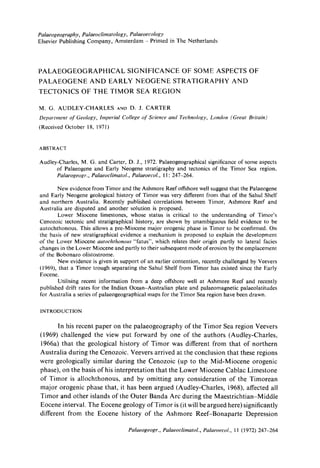
Fig.7. Diagrammatic explanation of the mode of formation of autochthonous "fatus" in
Timor based on evidence from the Booi and Lalan Asu regions of Indonesian Timor.
The term "fatu" is a local Timorese word which means rock. It is usually applied by the
Timorese people to a bare rock face of any mountain. Dutch geologists, who introduced the
word into the geological literature, have generally used the word "fatu" to refer to any steep-
walled limestone mountain in Timor (such mountains are a characteristic feature of the Timor
landscape). Many, but not all, of these "fatus" are isolated mountains, this strongly suggests
they represent erosional remnants of what was originally a more extensive limestone formation.
In this figure three main stages in the development of a "fatu" are recognised: a. By the
end of the Lower Miocene there was a series of reefs and banks of Cablac Limestone separated
by deeper water below which the Lower Miocene marls accumulated, b. During the Middle
Miocene Timor subsided and the Bobonaro Scaly Clay olistostrome was emplaced. As it moved
across Timor covering the submerged reefs and banks of Cablac Limestone it eroded the much
softer Lower Miocene marls, c. During the post-Miocene uplift of Timor the Bobonaro Scaly
Clay has been eroded from above and around the Cablac Limestone which now forms high,
prominent, isolated features of the Timor landscape.
Palaeogeogr., PalaeoelimatoL, Palaeoecol., 11 (1972) 247-264
17. CENOZOIC STRATIGRAPHY AND PALAEOGEOGRAPHY OF TIMOR 263
year between the Oligocene and the present (i.e., a distance of about 3,200 km
during the last 40 m.y.). Veevers et al. (1971) quoted palaeomagnetic evidence
which indicates that Australia remained latitudinally static during most of the
Mesozoic but began to drift north in the Mid-Cretaceous. It now seems to be
generally agreed that Timor's spatial relationship with Australia has been relatively
stable since the Permian at least (Teichert, 1939; Audley-Charles, 1966b; Veevers,
1969; Veevers et al., 1971) so that at the onset of the Cenozoic, Timor, which seems
to form the leading continental edge of the Australian plate, appears to have been
situated more than 3,200 km to the south of its present position. The actual figure
may be estimated as about 4,000 km as Veevers et al. (1971) quoted a figure of
40 degrees of latitude as the movement of Australia northwards since the Mid-
Cretaceous and the figure quoted by Laughton et al. (1970) related only to move-
ments since the end of the Eocene.
The ancient Tethys ocean, which during the Late Palaeozoic and Mesozoic
had probably separated Timor from the Asian continent, was therefore at the
onset of the Cenozoic probably about 4,000 km wide between Timor and what are
now the Cenozoic volcanic islands of Flores, Alor and Wetar. It seems likely that
it was the consumption of the oceanic lithosphere, which formed the northeast
part of the Australian plate, that, as it drifted northwards and descended below the
Asian plate, gave rise to the volcanic products that make up much of the islands
of Flores, Alor and Wetar (cf., Fitch, 1970).
REFERENCES
Audley-Charles, M. G., 1965. A geochemical study of Cretaceous ferromanganiferous sedi-
mentary rocks from Timor. Geoehim. Cosmochim. Aeta, 29:1153-1173.
Audley-Charles, M. G., 1966a. The age of the Timor Trough. Deep-Sea Res., 13: 761-763.
Audley-Charles, M. G., 1966b. Mesozoic palaeogeography of Australasia. Palaeogeogr., Palaeo-
climatol., Palaeoecol., 2: 1-25.
Audley-Charles, M. G,, 1968. The geology of Portuguese Timor. Mem. Geol. Soc. Lond., 4: 1-76.
Boutakoff, N. A., 1968. Oil prospects of Timor and the Outer Banda Arc, S.E. Asia. Aust. Oil
Gas Rev., April 1968: 44-55.
Brouwer, H. A., 1942. Summary of the geological results of the expedition. Geol. Exped. Lesser
Sunda Islands, 4" 349-402.
De Waard, D., 1954a. Geological research in Timor, an introduction. Inclones. J. Nat. Sei.,
110: 1-8.
De Waard, D., 1954b. The second geological Timor expedition, preliminary results. Indones.
J. Nat. Sci., 110: 154-160.
De Waard, D., 1957. The third Timor geological expedition, preliminary results, lndones. J.
Nat. Sei., 113: 7-42.
El Wakeel, S. K. and Riley, J. P., 1961. Chemical and mineralogical studies of deep-sea sediments.
Geochim. Cosmochim. Acta, 25: 110-146.
Fitch, T. J., 1970. Earthquake mechanisms and island arc tectonics in the Indonesian-Philippine
region. Bull. Seismol. Soc. Am., 60: 565-591.
Grunau, H. R., 1957. Neue Daten zur Geologie von Portugiesisch Osttimor. Eelogae Geol.
Helv., 50: 69-98.
Laughton, A. S., Matthews, D. H. and Fisher, R. L., 1970. The structure of the Indian Ocean.
In: A. E. Maxwell (Editor), The Sea. Wiley, New York, N.Y., 4: 543-586.
Palaeogeogr., Palaeoclimatol., Palaeoecol., 11 (1972) 247-264
18. 264 M. G. AUDLEY-CHARLES AND D. J. CARTER
Lemoine, M., 1959. Un example de tectonique chaotique; Timor. Rev. G~ogr.Phys. G~oLDyn.,
2(4): 205-230.
Molengraaff, G. A. F., 1914. Folded mountain chains, overthrust sheets and block faulted
mountains in the East Indian Archipelago. C.R. Int. Geol. Congr,, 12th, Toronto, 1913,
8: 689-702.
Molengraaff, G. A. F., 1922. On manganese nodules in Mesozoic deep-sea deposits of Dutch
Timor. K. Ned. Akad. Wet., Proc., 23: 997-1012.
Mollan, R. G., Craig, R. W. and Lofting, M. J. W., 1970. Geologic framework of continental
shelf off northwest Australia. Bull. Am. Assoc. Pet. Geologists, 54(4): 583-600.
Tappenbeck, D., 1940. Geologie des Mollogebirges und einiger benachbarter Gebiete. Geol.
Exped. Lesser Sunda Islands, 1: 1-105.
Teichert, C., 1939. The Mesozoic transgressions in western Australia. Aust. J. Sci., 2(1): 84-86.
'T Hoen, C. W. A. P. and Van Es, L. J. C., 1928. De opsporingen naar delfstoffen op bet eiland
Timor. Jaarb. Mijnwez. Ned. Indic, 1925, 2: 1-80.
Van Bemmelen, R. W., 1949. The Geology of Indonesia. Government Printing Office, The Hague,
997 pp.
Van Voorthuysen, J. H., 1940. Geologische Untersuchungen im distrikt Amfoan (Nordwest
Timor). Geol. Exped. Lesser Sunda Islands, 2: 345-368.
Van West, F. P., 1941. Geological investigations in the Miomaffo region (Netherlands Timor).
Geol. Exped. Lesser Snnda Islands, 3: 1-131.
Veevers, J. J., 1969. Palaeogeography of the Timor Sea region. Palaeogeogr., Palaeoclimatol.,
PalaeoeeoL, 6: 125-140.
Veevers, J. J., Jones, J. G. and Talent, J. A., 1971. Indo-Australian stratigraphy and the con-
figuration and dispersal of Gondwanaland. Nature, 229(5284): 383-388.
Palaeogeogr., Palaeoclimatol., Palaeoecol., 11 (1972) 247-264