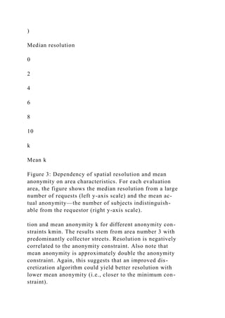
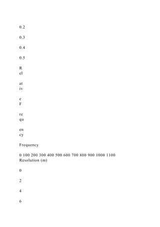
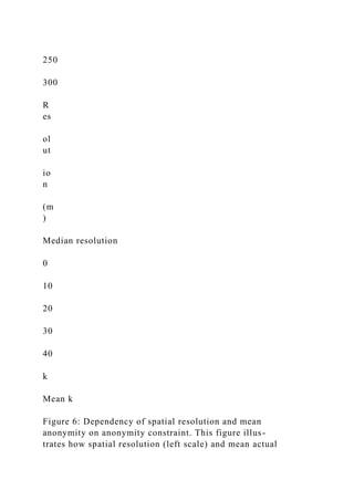
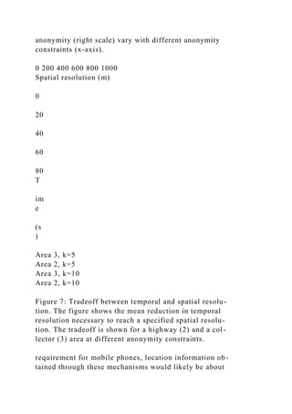
The document discusses the privacy risks associated with location-based services and presents a middleware architecture that utilizes adaptive algorithms to ensure anonymity in location data. It introduces methods for adjusting location information's spatial and temporal resolution to meet anonymity constraints, aiming to prevent re-identification of users. The results indicate that a median spatial resolution of 125 meters is sufficient for urban applications, aligning with e-911 service accuracy requirements.
![125 meters. Thus, anonymous location-based requests
for urban areas would have the same accuracy currently
needed for E-911 services; this would provide sufficient
resolution for wayfinding, automated bus routing ser-
vices and similar location-dependent services.
1 Introduction
Improvements in sensor and wireless communication
technology enable accurate, automated determination
and dissemination of a user’s or object’s position [1, 2].
There is an immense interest in exploiting this positional
data through location-based services (LBS) [3, 4, 5, 6].
For instance, LBSs could tailor their functionality to the
user’s current location, or vehicle movement data would
improve traffic forecasting and road planning.
However, without safeguards, extensive deployment
of these technologies endangers users’ location privacy
and exhibits significant potential for abuse [7, 8, 9].
Common privacy principles demand, among others, user
consent, purpose binding,1 and adequate data protection
1 When seeking user consent, data collectors need to explain the
spe-
cific purpose for which the data will be used. Subsequent use
for other
purposes is prohibited without additional user approval.
for collection and usage of personal information [10].
Complying with these principles generally requires no-
tifying users (data subjects) about the data collection and
the purpose through privacy policies; it also entails im-
plementing security measures to ensure that collected
data is only accessed for the agreed-upon purpose.
This paper investigates a complimentary approach that](https://image.slidesharecdn.com/anonymoususageoflocation-basedservicesthroughspatialand-221116064520-d3101500/85/Anonymous-Usage-of-Location-Based-Services-Through-Spatial-and-docx-2-320.jpg)
![concentrates on the principle of minimal collection. In
this approach location-based services collect and use
only de-personalized data—that is, practically anony-
mous data [11]. This approach promises benefits for both
parties. For the service provider, practically anonymous
data causes less overhead. It can be collected, processed,
and distributed to third parties without user consent. For
data subjects, it removes the need to evaluate potentially
complex service provider privacy policies.
Practical anonymity requires that the subject cannot
be reidentified (with reasonable efforts) from the loca-
tion data. Consider a message to a road map service that
comprises a network address, a user ID, and coordinates
of the current location. Identifiers like the user ID and
the network address are obvious candidates for reiden-
tification attempts. For anonymous service usage, the
user ID can be omitted and the network address prob-
lem is addressed by mechanisms such as Crowds [12] or
Onion Routing [13], which provide sender anonymity.
However, revealing accurate positional information
can pose even more serious problems. Consider a bus
wayfinding application that overlays bus route and ar-
rival information, such as that marketed by NextBus [14].
The Global Positioning System (GPS) typically provides
10–30 foot accuracy, and this accuracy can be increased
using enhancement techniques, such as differential GPS.
A location-based service could query a bus transit server
and return information about buses in the current vicin-
ity and when they will arrive at various stops. By issu-
ing such a query, the location-based service has learned
information about the application user, including her lo-
cation and some network identity information. This lo-
cation information can be correlated with public knowl-
edge to reidentify a user or vehicle. For example, when](https://image.slidesharecdn.com/anonymoususageoflocation-basedservicesthroughspatialand-221116064520-d3101500/85/Anonymous-Usage-of-Location-Based-Services-Through-Spatial-and-docx-3-320.jpg)
![• an evaluation of the expected resolution for these al-
gorithms based on traffic models comprised of car-
tographic material and automotive traffic counts
The structure of the paper is as follows: First we re-
view related work in the areas of location privacy, anony-
mous communication, and privacy-aware databases. In
Section 3 we describe location-based service scenarios
from the telematics domain and discuss their data ac-
curacy requirements. Section 4 then analyzes privacy
threats caused by the location information used in LBSs.
We continue by developing the concept of k-anonymous
location information and an algorithm for cloaking too
precise information in section 5. After that, we describe
our implementation and evaluation based on automotive
traffic models and present the corresponding results. Fi-
nally, we discuss the usefulness of the cloaking algo-
rithms as well as security and anonymity properties of
the system.
2 Related Work
Prior work on privacy aspects of telematics and location-
based applications has mostly focused on a policy-based
approach [15, 16]. Data subjects need to evaluate and
choose privacy policies offered by the service provider.
These policies serve as a contractual agreement about
which data can be collected, for what purpose the data
can be used, and how it can be distributed. Typically, the
data subject has to trust the service provider that private
data is adequately protected. In contrast, the anonymity-
based approach de-personalizes data before collection,
thus detailed privacy-policies and safeguards for data are
not critical.](https://image.slidesharecdn.com/anonymoususageoflocation-basedservicesthroughspatialand-221116064520-d3101500/85/Anonymous-Usage-of-Location-Based-Services-Through-Spatial-and-docx-5-320.jpg)
![Specifically, the IETF Geopriv working group [15]
is addressing privacy and security issues regarding the
transfer of high resolution location information to exter-
nal services and the storage at location servers. It con-
centrates on the design of protocols and APIs that en-
able devices to communicate their location in a confiden-
tial and integrity-preserving manner to a location server.
The location server can reduce the data’s resolution or
transform it to different data formats, which can be ac-
cessed by external services if the data subject’s privacy
policy permits. The working group is also interested in
enabling unidentified or pseudonymous transfer of loca-
tion information to the server and access from the server.
However, it does not claim that this provides a sufficient
degree of anonymity.
The Mist routing project for mobile users [17] com-
bines location privacy with communication aspects. It
addresses the problem of routing messages to a sub-
ject’s location while keeping the location private from the
routers and the sender. To this end, the system comprises
a set of mist routers organized in a hierarchical structure.
The leaf nodes have knowledge of user locations but not
their identities. They refer to them through handles (or
pseudonyms). Each user selects a higher-level node in
the tree, which acts as a semi-trusted proxy. It knows
the identity of the user but not his exact location. The
paper then presents a cryptographic protocol to establish
connections between users and their semi-trusted prox-
ies and mechanisms to connect to communication part-
ners through their proxies. The paper does not address
the problem of sending anonymous messages to external
location-based services.
Location privacy has also been studied in position sen-
sor systems systems. The Cricket system [1] places lo-](https://image.slidesharecdn.com/anonymoususageoflocation-basedservicesthroughspatialand-221116064520-d3101500/85/Anonymous-Usage-of-Location-Based-Services-Through-Spatial-and-docx-6-320.jpg)
![cation sensors on the mobile device as opposed to the
building infrastructure. Thus, location information is not
disclosed during the position determination process and
the data subject can choose the parties to which the in-
formation should be transmitted. Smailagic and Kogan
describe a similar approach for a wireless LAN based
location system [18]. However, these solutions do not
provide for anonymity when location information is in-
tentionally revealed.
Anonymous communication in packet-switching net-
works and web browsing has received a fair amount of
attention. The fundamental concept of a mix has been
proposed by Chaum [19] for email communications that
are untraceable even for eavesdroppers and intermediary
routers. A mix is a message router that forwards mes-
sages with the objective that an adversary cannot match
incoming messages to outgoing messages. In particular,
such Chaum-mixes have the following properties: mes-
sages are padded to equal size, incoming and outgoing
messages are encrypted with different keys, messages are
batched and reordered, and replay of incoming messages
is prevented. Pfitzmann and colleagues [20] extend this
mechanism to communication channels with continuous,
delay-sensitive voice traffic.
Onion Routing [21] implements this anonymization
protocol for an IP network layer and is applicable to
both connection-based and connectionless protocols. In
an initialization phase, the sender determines a route
through a series of onion routers. The sender then re-
peatedly adds routing information to the payload and
encrypts it using the onion routers public key. The re-](https://image.slidesharecdn.com/anonymoususageoflocation-basedservicesthroughspatialand-221116064520-d3101500/85/Anonymous-Usage-of-Location-Based-Services-Through-Spatial-and-docx-7-320.jpg)
![sult is an onion consisting of several layers of encryption
that are stripped off while the packet passes through the
router. Since the onion routers act as mix routers, it is
difficult to trace the path of a data packet through the
network.
Crowds [12] adapts a rerouting system for anonymous
web browsing. This system focuses on protecting against
individual adversaries, such as the web server, or a num-
ber of compromised routers. It does not require en-
cryption techniques, because it relies on the jondos (mix
routers) to be set up in different administrative domains.
Thus no party has a global network view over all jon-
dos. The Anonymizer service [22] has a similar goal,
whereby users need to trust the single service provider.
Finally, Hordes [23] reduced the performance overhead
inherent in such rerouting systems by exploiting multi-
cast communications and Guan et al. [24] contributed an
analysis of anonymity properties of these systems using
the probabilistic method.
In the database community, a large amount of liter-
ature exists on security control in statistical databases,
which is covered by Adam and Wortmann’s survey [25].
This research addresses the problem wherein a database
should grant access to compute statistical functions (sum,
count, average, etc.) on the data records only under the
condition that the results do not reveal any specific data
record. Approaches fall into the categories conceptual,
input data perturbation, query restriction, and output per-
turbation; the solution we propose in this paper is similar
to input data perturbation.
Instead of statistical point estimates, Agrawal and
Srikant [26] describe how to obtain estimates of the dis-
tribution of values in confidential fields, which are suit-](https://image.slidesharecdn.com/anonymoususageoflocation-basedservicesthroughspatialand-221116064520-d3101500/85/Anonymous-Usage-of-Location-Based-Services-Through-Spatial-and-docx-8-320.jpg)
![able for data-mining algorithms. Confidential values are
perturbed by adding a uniformly distributed random vari-
able. The distribution of the original values can then be
estimated through a Bayesian reconstruction procedure.
An improved reconstruction procedure is described in
[27].
Samarati and Sweeney [28] have developed general-
ization and suppression techniques for values of database
tables that safeguard the anonymity of individuals. While
this research is similar in goal, our work differs in that we
protect dynamic data delivered from sensors as opposed
to static database tables.
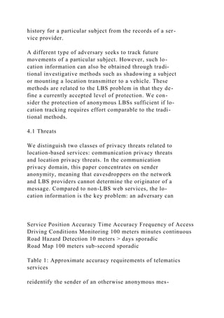
3 Accuracy Requirements of
Location-Based Telematics Services
A key question for developing an anonymous LBS is:
How accurate does a location based service need to be in
order to provide useful information? It proves difficult to
determine minimum accuracy requirements, since, from
the service provider’s perspective, more accurate infor-
mation is generally more useful. However, we attempt
to convince the reader that more general information is
still sufficient for a large class of services by reviewing
example services and the E-911 requirements on mobile
phone carriers.
In October 1996, the United States Federal Commu-
nications Commission mandated the implementation of
position systems for wireless 911 emergency callers (E-
911) [29]. This service is designed to provide emer-
gency rescue and response teams with the location of a
cell phone emergency call, comparable to the traditional
“911” service for regular phones. In the final phase, wire-
less carriers are required to estimate the caller’s position](https://image.slidesharecdn.com/anonymoususageoflocation-basedservicesthroughspatialand-221116064520-d3101500/85/Anonymous-Usage-of-Location-Based-Services-Through-Spatial-and-docx-9-320.jpg)
![sage by correlating the location information with prior
knowledge or observations about a subject’s location.
Consider the case where a subject reveals her location
L in a message M to a location-based service and an
adversary A has access to this information. Then, sender
anonymity and location privacy is threatened by location
information in the following ways:
Restricted Space Identification. If A knows that space
L exclusively belongs to subject S then A learns
that S is in L and S has sent M . For example,
when the owner of a suburban house sends a mes-
sage from his garage or driveway, the coordinates
can be correlated with a database of geocoded postal
addresses (e.g., [30]) to identify the residence. An
address lookup in phone or property listings then
reveals the owner and likely originator of the mes-
sage.
Observation Identification. If A has observed the cur-
rent location L of subject S and finds a message M
from L then A learns that S has sent M . For ex-
ample, the subject has revealed its identity and lo-
cation in a previous message and then wants to send
an anonymous message. The later message can be
linked to the previous one through the location in-
formation.
Location Tracking. If A has identified subject S at lo-
cation Li and can link series of location updates
L1, L2, . . . , Li, . . . , Ln to the subject, then A learns
that S visited all locations in the series.
Location privacy threats describe the risk that an ad-
versary learns the locations that a subject visited (and](https://image.slidesharecdn.com/anonymoususageoflocation-basedservicesthroughspatialand-221116064520-d3101500/85/Anonymous-Usage-of-Location-Based-Services-Through-Spatial-and-docx-15-320.jpg)
![corresponding times). Through these locations, the ad-
versary receives clues about private information such
as political affiliations, alternative lifestyles, or medical
problems. Assuming that a subject does not disclose her
identity at such a private location, an adversary could still
gain this information through location tracking. If the
subject transmits her location with high frequency, the
adversary can, at least in less populated areas, link sub-
sequent location updates to the same subject. If at any
point the subject is identified, her complete movements
are also known.
5 Anonymizing Location Information
In our system model, the mobile nodes communicate
with external services through a central anonymity server
that is part of the trusted computing base. In an initial-
ization phase, the nodes will set up an authenticated and
encrypted connection with the anonymity server. When
a mobile node sends position and time information to
an external service, the anonymity server decrypts the
message, removes any identifiers such as network ad-
dresses, and perturbs the position data according to the
following cloaking algorithms to reduce the reidentifica-
tion risk. Moreover, the anonymity server acts as a mix-
router [19], which randomly reorders messages from sev-
eral mobile nodes, to prevent an adversary from linking
ingoing and outgoing messages at the anonymity server.
Finally, the anonymity server forwards the message to
the external service.
For designing the perturbation algorithms, we start
with the assumption that the anonymity server knows
the current position of all subjects. The subject’s mobile
nodes could periodically update their position informa-
tion with the anonymizer.](https://image.slidesharecdn.com/anonymoususageoflocation-basedservicesthroughspatialand-221116064520-d3101500/85/Anonymous-Usage-of-Location-Based-Services-Through-Spatial-and-docx-16-320.jpg)
![5.1 k-Anonymous Location Information
While anonymity is etymologically defined as “being
nameless” or “of unknown authorship” [31], informa-
tion privacy researchers interpret it in a stronger sense.
According to Pfitzmann and Koehntopp, “anonymity is
the state of being not identifiable within a set of sub-
jects, the anonymity set”[11]. Inspired by Samarati and
Sweeney [28], we consider a subject as k-anonymous
with respect to location information, if and only if the
location information presented is indistinguishable from
the location information of at least k − 1 other subjects.
Unless otherwise stated, we assume that location in-
formation includes temporal information (i.e., when the
subject was present at the location). More specifically,
location information is represented by a tuple contain-
ing three intervals ([x1, x2], [y1, y2], [t1, t2]). The inter-
vals [x1, x2] and [y1, y2] describe a two dimensional area
where the subject is located. [t1, t2] describes a time pe-
riod during which the subject was present in the area.
Note that the intervals represent uncertainty ranges; we
only know that at some point in time within the temporal
interval the subject was present at some point of the area
given by the spatial intervals. Thus, a location tuple for
a subject is k-anonymous, when it describes not only the
location of the subject, but also the locations of k − 1
other subjects. In other words, k − 1 other subjects also
must have been present in the area and the time period
described by the tuple. Generally speaking, the larger the
anonymity set k is, the higher is the degree of anonymity.
Thus, we will measure the degree of anonymity as the](https://image.slidesharecdn.com/anonymoususageoflocation-basedservicesthroughspatialand-221116064520-d3101500/85/Anonymous-Usage-of-Location-Based-Services-Through-Spatial-and-docx-17-320.jpg)
![size of the anonymity set.
5.2 Adaptive-Interval Cloaking Algorithms
The key idea underlying this algorithm is that a given de-
gree of anonymity can be maintained in any location—
regardless of population density—by decreasing the ac-
curacy of the revealed spatial data. To this end, the al-
gorithm chooses a sufficiently large area, so that enough
other subjects inhabit the area to satisfy the anonymity
constraint.
The desired degree of anonymity is specified by the
parameter kmin, the minimum acceptable anonymity set
size. Furthermore, the algorithm takes as inputs the cur-
rent position of the requester, the coordinates of the area
covered by the anonymity server, and the current posi-
tions of all other vehicles/subjects in the area.
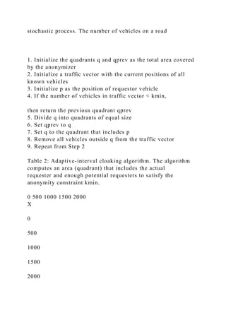
The spatial discretization algorithm that identifies a
sufficiently large area for a given kmin is described in
more detail in Table 2. In summary, the algorithm is in-
spired by quadtree algorithms [32]. It subdivides the area
around the subject’s position until the number of subjects
in the area falls below the constraint kmin. The previ-
ous quadrant, which still meets the constraint, is then re-
turned.
An orthogonal approach to spatial cloaking is tempo-
ral cloaking. This method can reveal spatial coordinates
with more accuracy, while reducing the accuracy in time.
The key idea is to delay the request until kmin vehicles
have visited the area chosen for the requestor. The spa-
tial cloaking algorithm is modified to take an additional
spatial resolution parameter as input. It then determines
the monitoring area by dividing the space until the spec-](https://image.slidesharecdn.com/anonymoususageoflocation-basedservicesthroughspatialand-221116064520-d3101500/85/Anonymous-Usage-of-Location-Based-Services-Through-Spatial-and-docx-18-320.jpg)
![ified resolution is reached. The algorithm monitors ve-
hicle movements across this area. When kmin different
vehicles have visited the area, a time interval [t1, t2] is
computed as follows: t2 is set to the current time, and
t1 is set to the time of request minus a random cloaking
factor. The area and the time interval are then returned.
6 Implementation
To be effective, the location anonymizer requires
location-based services that are used with precise posi-
tion information by a large user base. We anticipate that
such services will soon be available based on telemat-
ics, mobile phone, or wireless community network plat-
forms. To our knowledge, no such suitable testbed exists
to date. Therefore, we implemented the anonymization
algorithms on a Java server platform and evaluated them
using automotive traffic simulations based on US geo-
logical survey (USGS) cartographic material.
The USGS publishes detailed transportation network
information at the city level in the Spatial Data Transfer
Standard [33]. We extracted vector coordinates of pri-
mary, secondary, and minor roads from the transportation
layer of the 1 : 24, 000 scale Digital Line Graph [34]
data files. The data has a resolution of 0.61m. Specif-
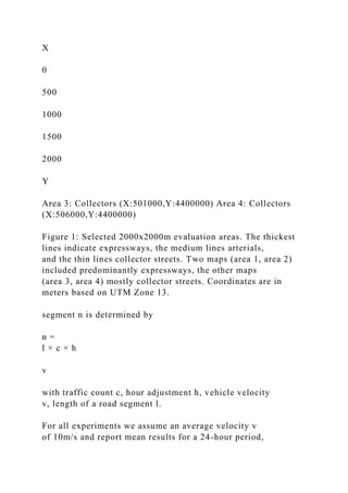
ically, we selected 2000x2000m areas from the city of
0 2 4 6 8 10 12 14 16 18 20 22
Hour
0
2
4](https://image.slidesharecdn.com/anonymoususageoflocation-basedservicesthroughspatialand-221116064520-d3101500/85/Anonymous-Usage-of-Location-Based-Services-Through-Spatial-and-docx-19-320.jpg)
![thickest lines indicate expressways, the medium lines ar-
terials, and the thin lines collector streets. Two maps
(area 1, area 2) included predominantly expressways, the
other maps (area 3, area 4) mostly collector streets. Co-
ordinates are given in meters in zone 13 of the Universal
Transverse Mercator (UTM) projection using the North
American 83 geodetic datum.
A traffic study [35] reports the 24 hour traffic volume
at specific points along roads. We averaged the counts
for different urban road types and mapped them onto the
USGS road classes as shown in Table 3. Traffic volume
was computed as the average 24 hour bi-directional traf-
fic count.
USGS Class Road Type Traffic Volume
1 Expressway 70000
2 Arterial 22000
3 Collector 6000
Table 3: Mapping of Traffic Study volumes to road
classes from USGS data
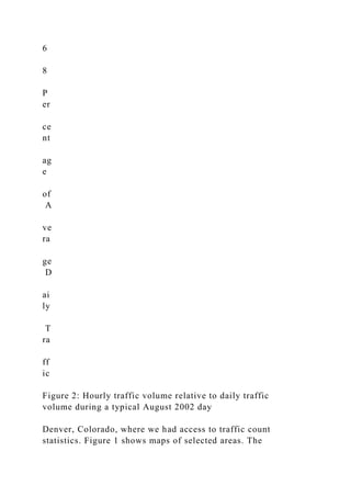
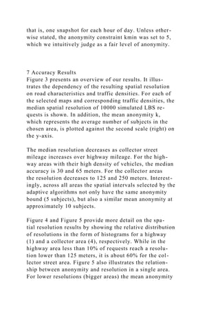
The algorithms are evaluated at different times of
day, because traffic volume changes heavily between
peak and night hours. An adjustment factor for each
hour was derived as follows. The Colorado Department
of Transportation maintains continuous traffic counters
along several highways. For each hour of a day, we cal-
culated the percentage of total daily traffic present during
this hour from the mean August 2002 traffic counts for 25
highways [36]. Figure 2 shows the results marked with
95% confidence intervals.
To create a traffic snapshot for a given hour, we place
vehicles on the road segments according to a uniform](https://image.slidesharecdn.com/anonymoususageoflocation-basedservicesthroughspatialand-221116064520-d3101500/85/Anonymous-Usage-of-Location-Based-Services-Through-Spatial-and-docx-21-320.jpg)

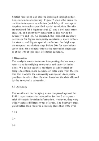


![would be a worthwhile continuation of this work.
8.2 Security Analysis
From a security perspective, the wireless carriers or
eavesdroppers can attempt to circumvent the location
anonymizer and accurately locate a subject using the
wireless channel. Authentication and encryption be-
tween the location client and the anonymity server ef-
fectively prevents them from listening to the exact coor-
dinates or impersonating anonymity servers. The times-
tamp in the location beacons ensures that the bitstring
of subsequent encrypted packets from the same location
differs and also protects from replay attacks.
More difficult to prevent are attempts to estimate the
location of a transmitter based on physical layer prop-
erties of the network. Several cooperating receivers can
triangulate the position of a transmitter through methods
such as time of arrival (TOA)[29]. Judging from the tech-
nical difficulties encountered in implementing the E-911
0.0027
0.084
0.29
0.55
0.07
0.0078
0
0.1](https://image.slidesharecdn.com/anonymoususageoflocation-basedservicesthroughspatialand-221116064520-d3101500/85/Anonymous-Usage-of-Location-Based-Services-Through-Spatial-and-docx-31-320.jpg)


![it is not clear whether the location update actually origi-
nated from the same subject. In other words, if multiple
subjects are using a LBS through the anonymity service,
it is difficult for the LBS to generate movement paths of
subjects even if they provide location updates with high
frequency.2
At this point, it is difficult to gauge which size of k
is minimally necessary or sufficient. Fundamentally, it
depends on the resources of the potential adversary. A
minimum of 2 is obviously required in this particular al-
gorithm to yield any protection. In practice, the parame-
ter will likely be determined through user preferences.
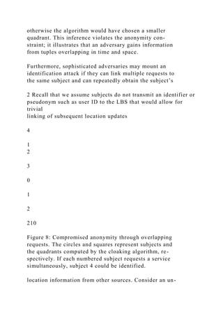
While the basic algorithm ensures k-anonymity for in-
dividual location requests, problems can arise when re-
quests for multiple vehicles are issued. Consider the fol-
lowing location tuples obtained from 4 different vehicles:
1 : ([0, 1], [0, 1], [t1, t2])
2 : ([1, 2], [0, 1], [t1, t2])
3 : ([0, 1], [1, 2], [t1, t2])
4 : ([0, 2], [0, 2], [t1, t2])
These tuples are overlapping in time and space. The
first three tuples specify adjacent quadrants, while the
fourth one specifies a larger quadrant that covers the
three others; this scenario is also illustrated in Figure 8.
For simplicity, assume that all tuples were processed
with the same kmin parameter, say 3, and the time inter-
val is too small for vehicles to significantly move. Then
an adversary can conclude that request number 4 must
have originated from quadrant ([1, 2], [1, 2]), because](https://image.slidesharecdn.com/anonymoususageoflocation-basedservicesthroughspatialand-221116064520-d3101500/85/Anonymous-Usage-of-Location-Based-Services-Through-Spatial-and-docx-37-320.jpg)
![networks use high-speed wireless networking to pro-
vide Internet access; one example are the wireless ac-
cess points common at coffee shops. These wireless net-
works have a limited range of 300–1500 feet, meaning
that coarse location information can be determined sim-
ply by associating with a specific access point. In these
networks, location based cloaking must occur at the ap-
plication, network and physical layers.
Acknowledgments
Paul Chou and our colleagues at the IBM T.J. Watson Re-
search Center encouraged us to research location privacy
challenges. The anonymous referees and our paper shep-
herd, Maria Ebling, provided useful comments on a draft
of this paper. This work was funded by award #9988548
from the Division of Computer-Communications Re-
search of the National Science Foundation. All views
and opinions stated reflect those of the authors, not those
of the National Science Foundation.
References
[1] Nissanka B. Priyantha, Anit Chakraborty, and Hari Bal-
akrishnan. The cricket location-support system. In Pro-
ceedings of the sixth annual international conference on
Mobile computing and networking, pages 32–43. ACM
Press, 2000.
[2] I. Getting. The global positioning system. IEEE Spec-
trum, 30(12):36–47, December 1993.
[3] Mike Spreitzer and Marvin Theimer. Providing loca-
tion information in a ubiquitous computing environment
(panel session). In Proceedings of the fourteenth ACM
symposium on Operating systems principles, pages 270–
283. ACM Press, 1993.](https://image.slidesharecdn.com/anonymoususageoflocation-basedservicesthroughspatialand-221116064520-d3101500/85/Anonymous-Usage-of-Location-Based-Services-Through-Spatial-and-docx-42-320.jpg)
![[4] Andy Harter, Andy Hopper, Pete Steggles, Andy Ward,
and Paul Webster. The anatomy of a context-aware ap-
plication. In Mobile Computing and Networking, pages
59–68, 1999.
[5] Rui Jose and Nigel Davies. Scalable and flexible location-
based services for ubiquitous information access. In
Proceedings of First International Symposium on Hand-
held and Ubiquitous Computing, HUC’99, pages 52–66.
Springer Verlag, 1999.
[6] C. Bisdikian, J. Christensen, J. Davis II, M. Ebling,
G. Hunt, W. Jerome, H. Lei, and S. Maes. Enabling
location-based applications. In 1st Workshop on Mobile
commerce, 2001.
[7] P. A. Karger and Y. Frankel. Security and privacy threats
to ITS. In Proceedings of the Second World Congress
on Intelligent Transport Systems, volume 5, Yokohama,
Japan, Nov 1995.
[8] Roy Want, Andy Hopper, Veronica Falco, and Jonathan
Gibbons. The active badge location system. ACM Trans-
actions on Information Systems (TOIS), 10(1):91–102,
1992.
[9] Philip E. Agre. Transport informatics and the new land-
scape of privacy issues. Computer Professionals for So-
cial Responsibility (CPSR) Newsletter, 13(3), 1995.
[10] Marc Langheinrich. Privacy by design – principles
of privacy-aware ubiquitous systems. In G.D. Abowd,
B. Brumitt, and S. Shafer, editors, Ubicomp 2001 Pro-](https://image.slidesharecdn.com/anonymoususageoflocation-basedservicesthroughspatialand-221116064520-d3101500/85/Anonymous-Usage-of-Location-Based-Services-Through-Spatial-and-docx-43-320.jpg)
![ceedings, volume 2201 of Lecture Notes in Computer Sci-
ence, pages 273–291. Springer, 2001.
[11] Andreas Pfitzmann and Marit Koehntopp. Anonymity,
unobservability, and pseudonymity — a proposal for ter-
minology. In Hannes Federrath, editor, Designing Pri-
vacy Enhancing Technologies — Proceedings of the In-
ternational Workshop on Design Issues in Anonymity and
Unobservability, volume 2009 of LNCS. Springer, 2000.
[12] Michael K. Reiter and Aviel D. Rubin. Crowds:
anonymity for Web transactions. ACM Transactions on
Information and System Security, 1(1):66–92, 1998.
[13] D. Goldschlag, M. Reed, and P. Syverson. Onion routing
for anonymous and private internet connections. Commu-
nications of the ACM (USA), 42(2):39–41, 1999.
[14] NextBus Information Systems. Nextbus website.
1321 67th Street, Emeryville, CA 94608, USA,
http://www.nextbus.com, Oct 2002.
[15] J. Cuellar, J. Morris, and D. Mulligan. Inter-
net engineering task force geopriv requirements.
http://www.ietf.org/html.charters/geopriv-charter.html,
Oct 2002.
[16] Sastry Duri, Marco Gruteser, Xuan Liu, Paul Moskowitz,
Ronald Perez, Moninder Singh, and Jung-Mu Tang.
Framework for security and privacy in automotive telem-
atics. In Proceedings of the second international work-
shop on Mobile commerce, pages 25–32. ACM Press,
2002.
[17] Jalal Al-Muhtadi, Roy Campbell, Apu Kapadia, M. Den-
nis Mickunas, and Seung Yi. Routing through the mist:](https://image.slidesharecdn.com/anonymoususageoflocation-basedservicesthroughspatialand-221116064520-d3101500/85/Anonymous-Usage-of-Location-Based-Services-Through-Spatial-and-docx-44-320.jpg)
![Privacy preserving communication in ubiquitous comput-
ing environments. In Proceedigns of IEEE International
Conference of Distributed Computing Systems (ICDCS),
pages 65–74, Vienna, Austria, Jul 2002.
[18] Asim Smailagic and David Kogan. Location sensing and
privacy in a context-aware computing environment. IEEE
Wireless Communications, 9(5):10–17, Oct 2002.
[19] David L. Chaum. Untraceable electronic mail, return ad-
dresses, and digital pseudonyms. Communications of the
ACM, 24(2):84–90, 1981.
[20] A. Pfitzmann, B. Pfitzmann, and M. Waidner. Isdnmixes:
Untraceable communication with very small bandwidth
overhead. In Wolfgang Effelsberg, Hans Werner Meuer,
and Günter Müller, editors, Proceedings of Kommunika-
tion in Verteilten Systemen, Grundlagen, Anwendungen,
Betrieb, GI/ITG-Fachtagung, volume 267 of Informatik-
Fachberichte, Mannheim, Germany, Feb 1991. Springer.
[21] David Goldschlag, Michael Reed, and Paul Syverson.
Onion routing. Communications of the ACM, 42(2):39–
41, 1999.
[22] Anonymizer. Anonymizer website. 5694 Mis-
sion Center Road #426, San Diego, CA 92108-4380,
http://www.anonymizer.com, 2000.
[23] Clay Shields and Brian Neil Levine. A protocol for
anonymous communication over the internet. In Proceed-
ings of the 7th ACM conference on Computer and commu-
nications security, pages 33–42. ACM Press, 2000.
[24] Yong Guan, Xinwen Fu, Riccardo Bettati, and Wei Zhao.
A quantitative analysis of anonymous communications.](https://image.slidesharecdn.com/anonymoususageoflocation-basedservicesthroughspatialand-221116064520-d3101500/85/Anonymous-Usage-of-Location-Based-Services-Through-Spatial-and-docx-45-320.jpg)
![IEEE Transactions on Reliability, (to appear).
[25] Nabil R. Adam and John C. Worthmann. Security-control
methods for statistical databases: a comparative study.
ACM Computing Surveys (CSUR), 21(4):515–556, 1989.
[26] Rakesh Agrawal and Ramakrishnan Srikant. Privacy-
preserving data mining. In Proceedings of the ACM SIG-
MOD Conference on Management of Data, pages 439–
450. ACM Press, May 2000.
[27] Dakshi Agrawal and Charu C. Aggarwal. On the design
and quantification of privacy preserving data mining algo-
rithms. In Proceedings of the twentieth ACM SIGMOD-
SIGACT-SIGART symposium on Principles of database
systems, pages 247–255. ACM Press, May 2001.
[28] P. Samarati and L. Sweeney. Protecting privacy when
disclosing information: k-anonymity and its enforcement
through generalization and suppression. Technical Re-
port SRI-CSL-98-04, Computer Science Laboratory, SRI
International, 1998.
[29] J. Reed, K. Krizman, B. Woerner, and T. Rappaport. An
overview of the challenges and progress in meeting the
e-911 requirement for location service. IEEE Personal
Communications Magazine, 5(3):30–37, April 1998.
[30] Tele Atlas North America, Inc. Geocode web-
site. 1605 Adams Drive, Menlo Park, CA 94025,
http://www.geocode.com/, Oct 2002.
[31] J.A. Simpson and E.S.C. Weiner, editors. Oxford English
Dictionary, Second Edition. Clarendon Press, 1989.
[32] Hanan Samet. The Design and Analysis of Spatial Data](https://image.slidesharecdn.com/anonymoususageoflocation-basedservicesthroughspatialand-221116064520-d3101500/85/Anonymous-Usage-of-Location-Based-Services-Through-Spatial-and-docx-46-320.jpg)
![Structures. Addison-Wesley, Reading, MA, 1990.
[33] U.S. Geological Survey (USGS). Spatial data transfer
standard. 12201 Sunrise Valley Drive, Reston, VA 20192,
USA, http://mcmcweb.er.usgs.gov/sdts/,
1995.
[34] U.S. Geological Survey (USGS). Digital line graph data.
12201 Sunrise Valley Drive, Reston, VA 20192, USA,
http://edc.usgs.gov/geodata/, Oct 2002.
[35] DCROG. Denver regional council of governments: Den-
ver regional travel behavior inventory, 2001. 2480 W.
26th Avenue, Suite 200B, Denver, CO 80211-5580.
[36] Colorado Department of Transportation. Traf-
fic statistics & data. Public Relations Of-
fice, 4201 E Arkansas Ave, Denver, CO 80222,
http://www.dot.state.co.us/, Oct 2002.](https://image.slidesharecdn.com/anonymoususageoflocation-basedservicesthroughspatialand-221116064520-d3101500/85/Anonymous-Usage-of-Location-Based-Services-Through-Spatial-and-docx-47-320.jpg)