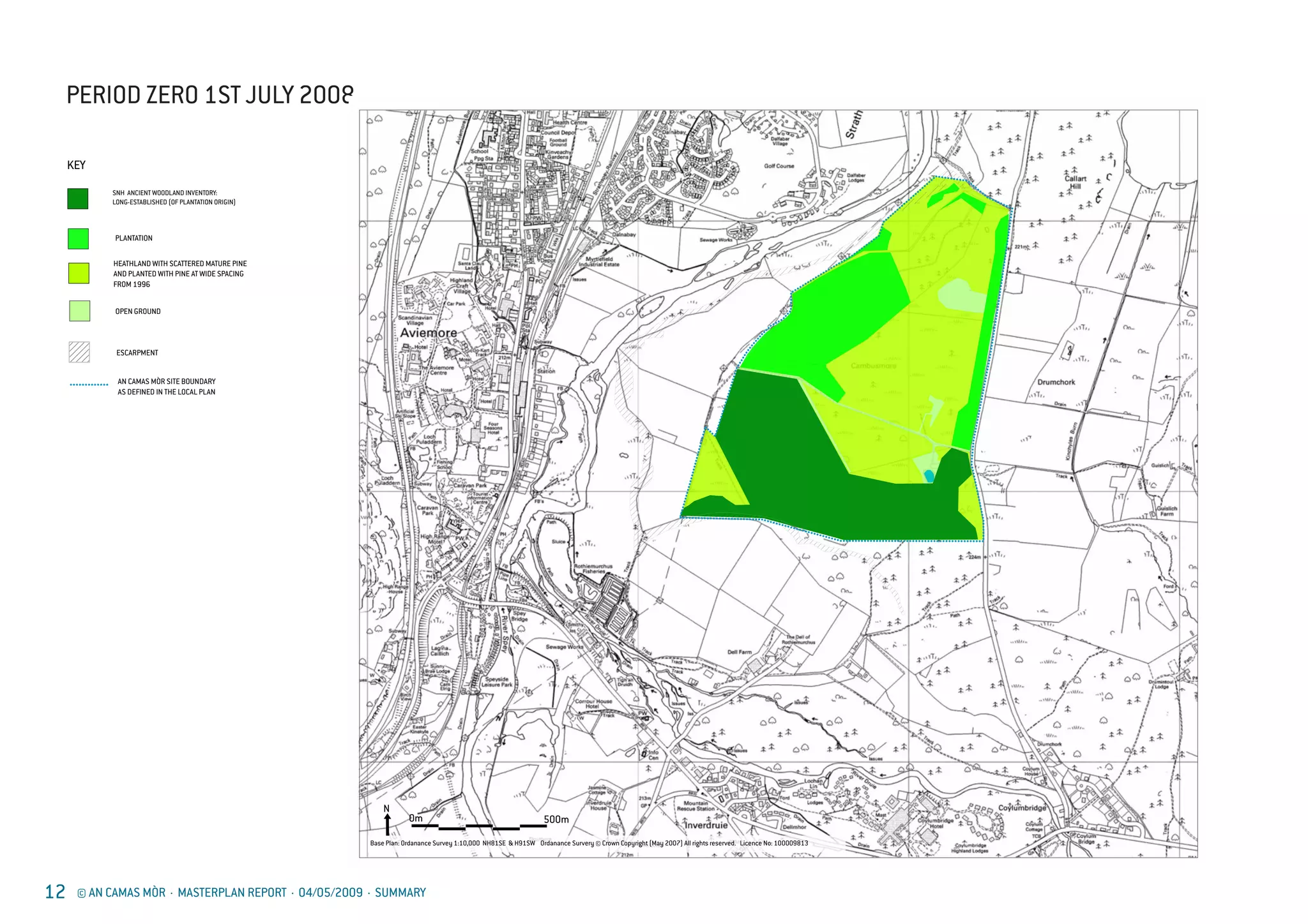
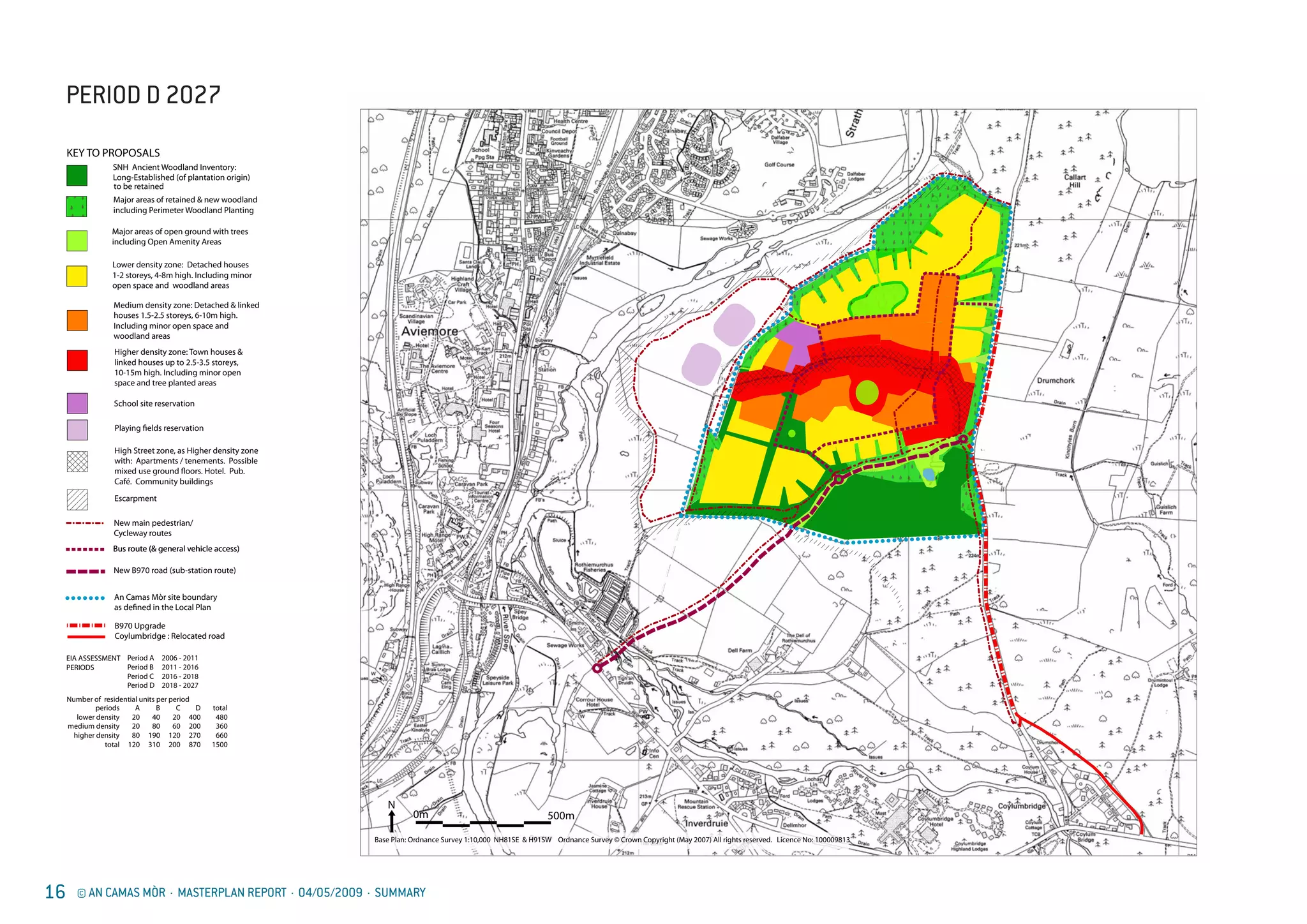
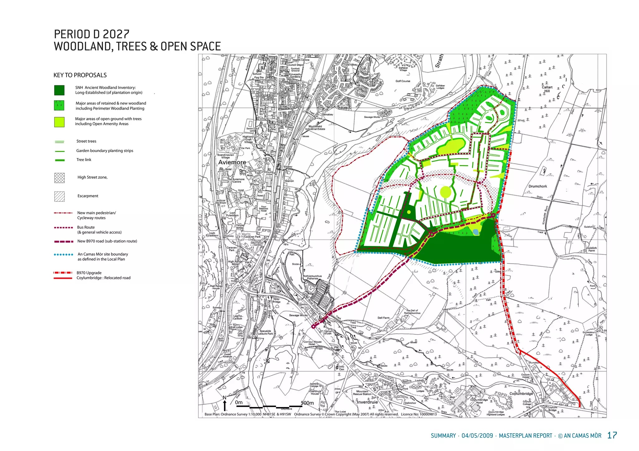
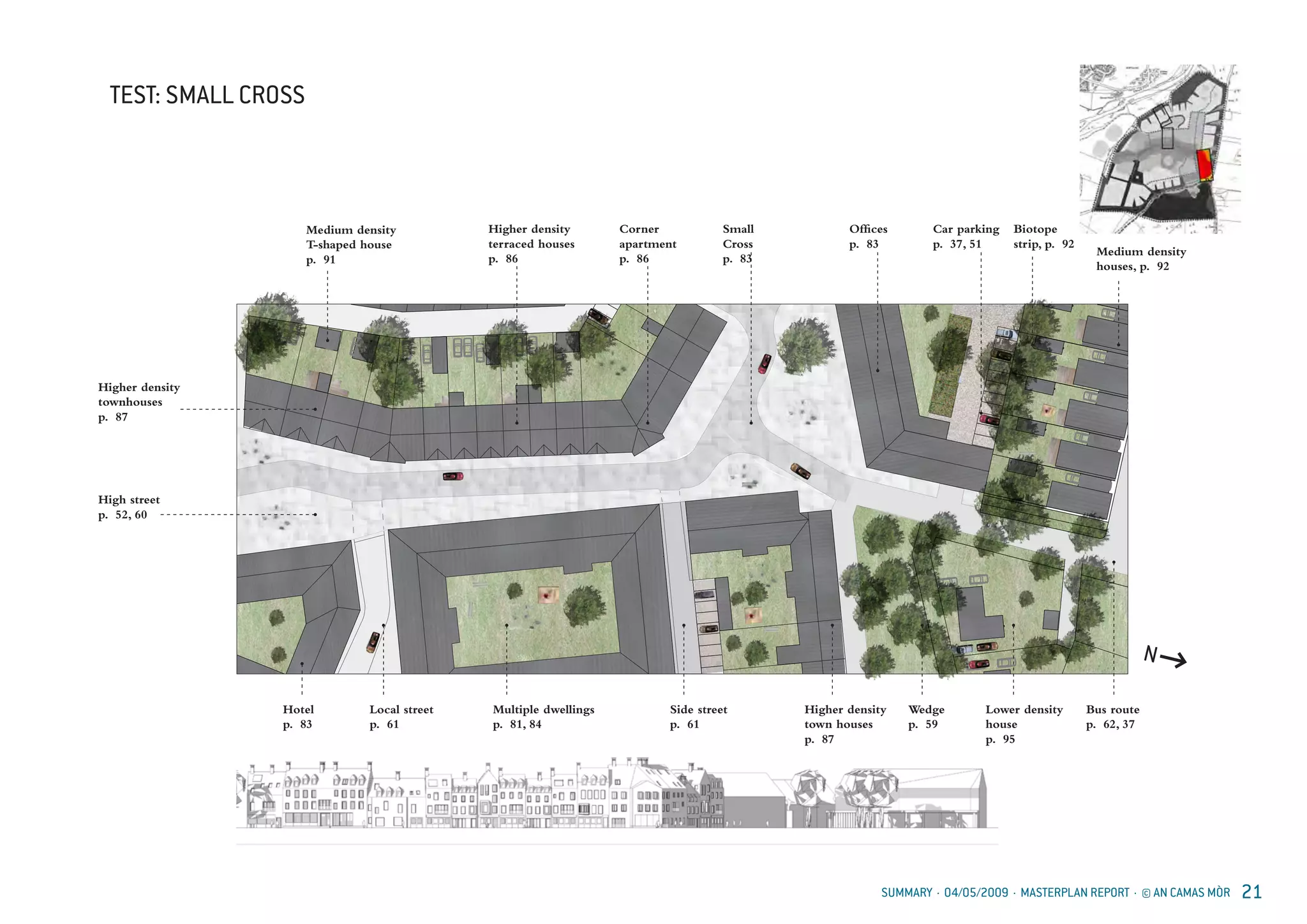
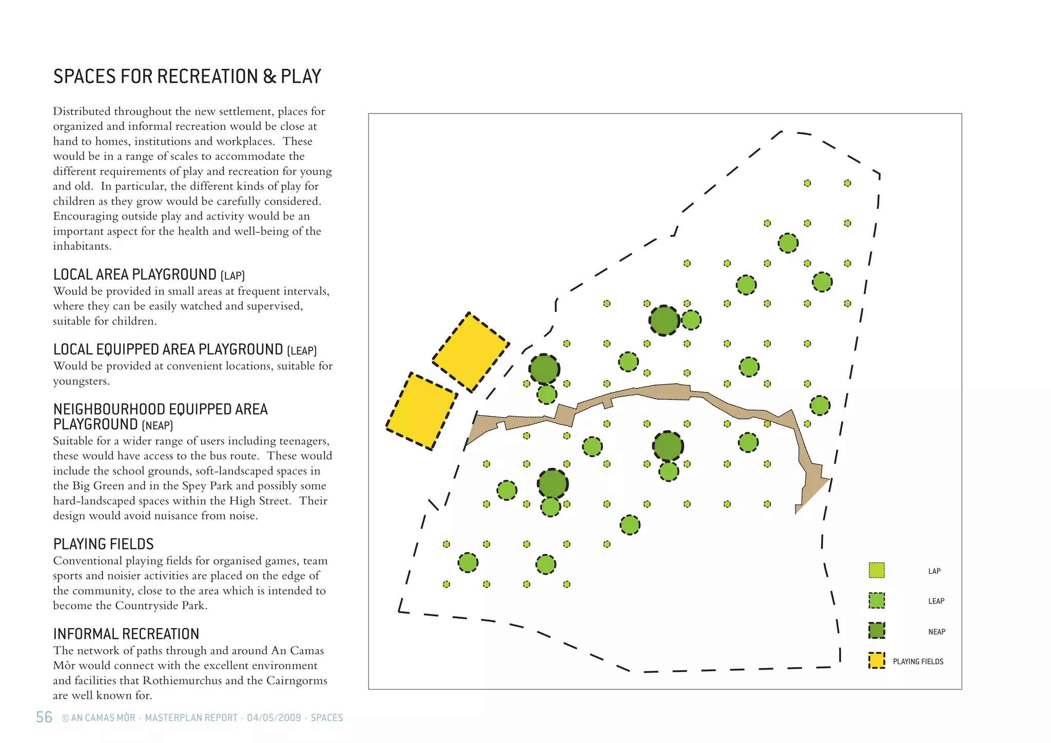
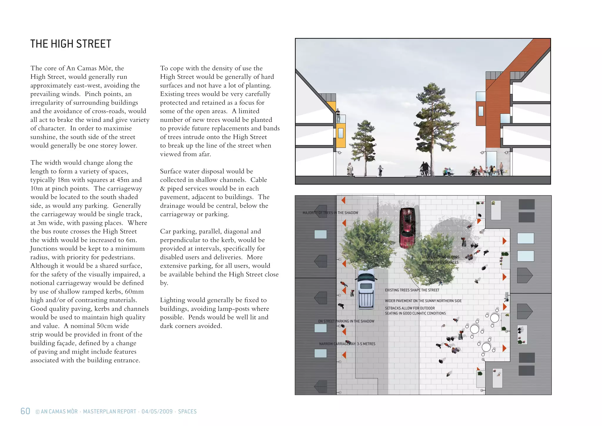
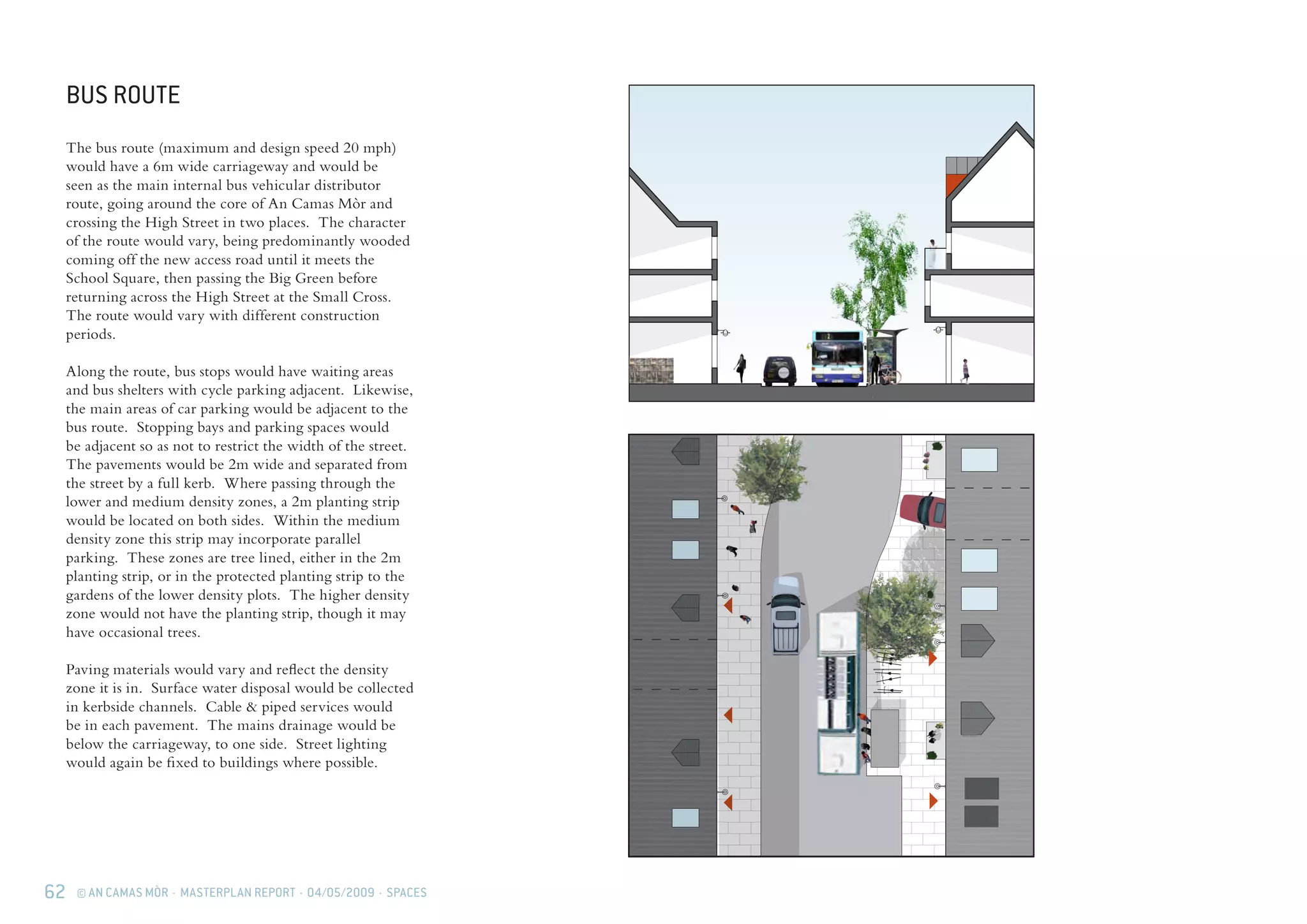
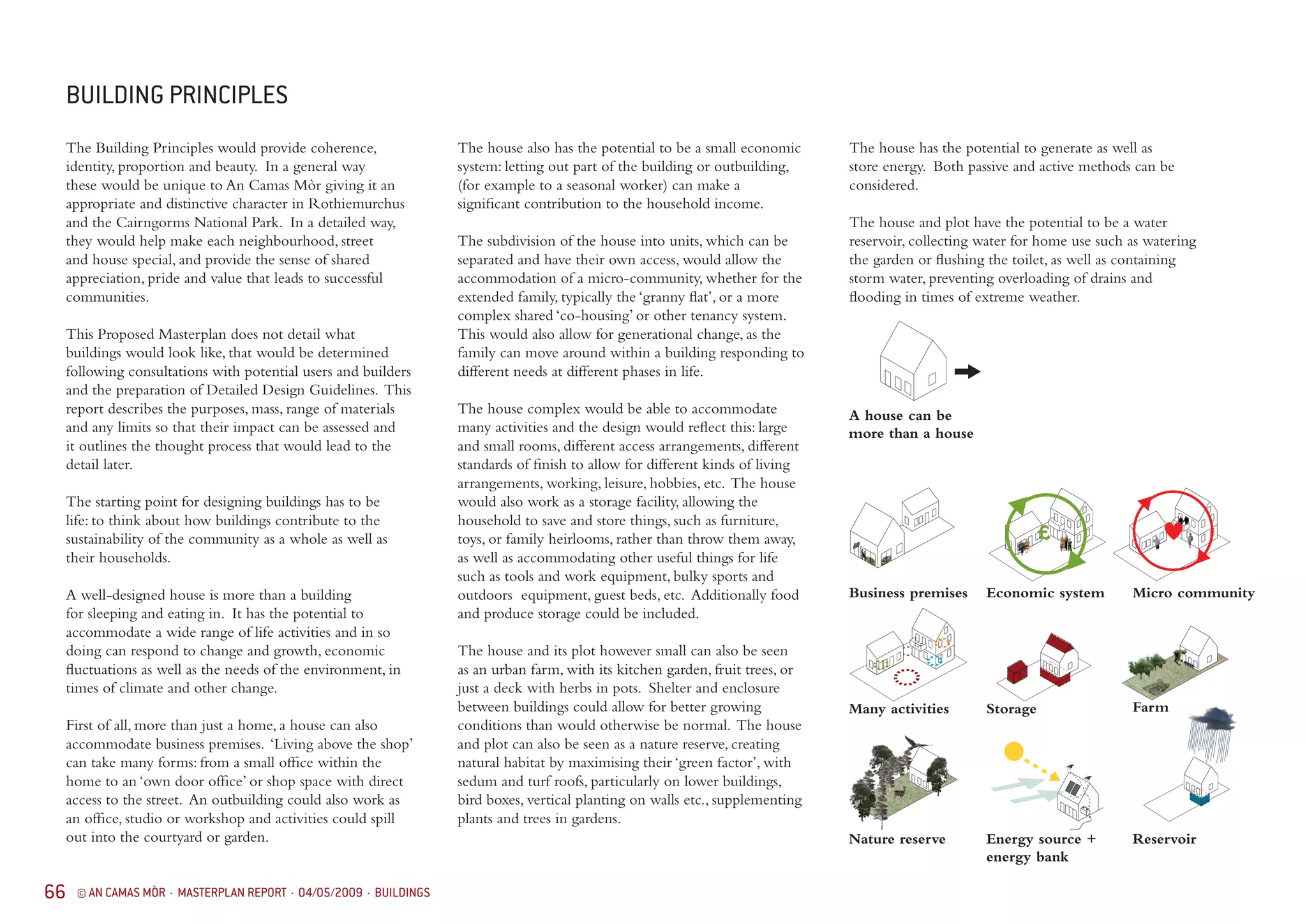
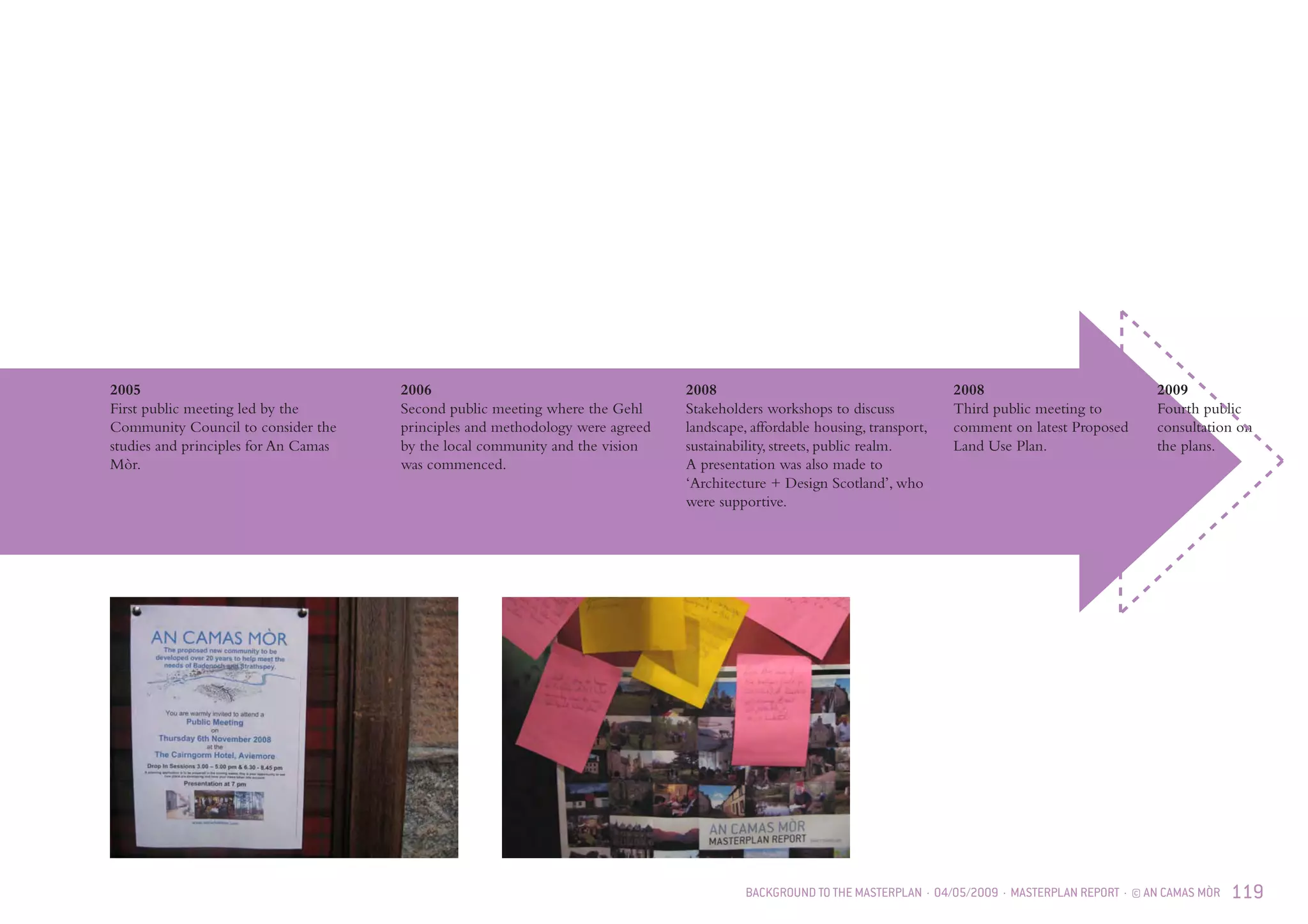
PROPOSED MASTERPLAN REPORT
2 © AN CAMAS MÒR · MASTERPLAN REPORT · 04/05/2009
ARCHITECTURAL TEAM
GEHL ARCHITECTS ApS
Gl. Kongevej 1, 4. tv.
DK-1610 Copenhagen V
CVR-nr.: 25 30 95 29
Tel.: + 45 32 950 951
Fax: +45 32 950 958
mail@gehlarchitects.dk
www.gehlarchitects.dk
David Sim
Director
Architect SAR/MSA
Louise Didriksson
Architect LAR/MSA
Tobias Gagner
Architect MSA
Ola Gustafsson
Architect MSA
Fredrik Garpen-
feldt
Architect MSA
Elisabeth Hag-
strömer
Trainee
Benjamin Tindall
Partner
ARIAS RIBA FSA
Mark Thomasson
Associate
ARIAS
Caroline Slater
Assistant
MA Hons Dip Arch
Kieran Gaffney
Architect
ARIAS, BscHons DipArch
Jan Gehl
Founding Partner
Architect MAA,
Int FRIBA, Hon.
FAIA, Professor,
Dr.Litt
Johanna Enhörning
Trainee
04/05/2009 · MASTERPLAN REPORT · © AN CAMAS MÒR 3
4 © AN CAMAS MÒR · MASTERPLAN REPORT · 04/05/2009
SUMMARY
Summary & location			 10
Delivery
Period zero				 12
Period A				 13
Period B					 14
Period C				 15
Period D				 16
Woodland, trees & open space		 17
Test
Lower density				 18
Main Cross				 19
East Square				 20
Small Cross				 21
CONTENTS
INTRODUCTION
Team					 2
Contents				 4
Recommendation			 6
Preface					 7
LIFE
A fresh approach to building a community
– putting life first				 32
Different needs of a diverse community	 34
Employment				 35
Mobility & access			 36
Encouraging natural life
– celebrating wildness			 38
Basic principles				 39
Ethos					 40
Encouraging community life		 41
VISION & METHODOLOGY
Gehl methodology			 24
Genus loci: a sense of place		 26
Vision					 27
Achieving sustainability			 28
04/05/2009 · MASTERPLAN REPORT · © AN CAMAS MÒR 5
BUILDINGS
Building principles			 66
Different densities			 70
Sustainability				 71
Design guidelines			 72	
Boundary				 73
Roofs					 74
Walls					 75
Wall openings				 76	
Details					 77
Materials & colour			 78	
Joy & beauty				 79
Workplaces				 80
Multiple dwelling on the same plot		 81
Higher density
Public buildings				 82	
Non/residential private buildings		 83
Residential buildings			 84
Apartment buildings			 85
Apartment corner buildings		 86
Town houses				 87
Terraced houses				 88
Medium density			
Workshops				 89
Residential buildings			 90
T-shaped houses				 91
Side-by-side houses			 92
Courtyard houses			 93
Conventional houses			 94
Lower density
Residential buildings			 95
SPACES
Proposed layout				 46
Spaces for life				 48
Mobility principles			 50
The High Street				 52
Public spaces in the High Street		 54
Main Cross				 55
Spaces for recreation & play		 56
Spaces for contact with nature		 58
Closer to nature				 59
High Street				 60
Side streets				 61
Local bus route/service street		 62
Local streets/cul-de-sacs			 63
BACKGROUND TO THE PROPOSED
MASTERPLAN
The brief for An Camas Mòr		 98
The need for a new community		 100
National guidance			 101
Development capacity			 101
Local development policies		 101
Other guidance				 101
National park context			 102
National scenic area context		 102
Regional context				 102
The site					 103
Landscape context			 105
Natural heritage context			 105
Historic context				 106
Townscape context			 108
Scottish urban patterns			 111
Architectural context			 112
Identity					 114
Connections				 115
Constraints				 116
Opportunities				 117
Community instigation and involvement	 118
Conclusion				 120
6 © AN CAMAS MÒR · MASTERPLAN REPORT · 04/05/2009
RECOMMENDATION
I am pleased to recommend the Proposed Masterplan
for a proposed new community at An Camas Mòr. A
chronic shortage of planned housing for local residents,
associated business and community facilities and
provision for the necessary infrastructure has beset
Aviemore for over 40 years. An Camas Mòr (then
Cambusmore) was first proposed by Community
representatives in 1989 and was adopted into planning
policy from 1997; the Outline Planning process is the
important next step of realising their vision which
would be completed by 2027.
The team, inspired by David Sim of Gehl Architects,
Copenhagen, has proposed a Masterplan that
establishes the framework for a village in which
generations of residents would be able to live full,
happy and healthy lives. An Camas Mòr would
have to meet a unique range of criteria, for example
it lies at the heart of the Cairngorms National Park
and a National Scenic Area, it must support nature
conservation and environmental objectives as well
as being affordable in a new and more challenging
economic background. Building principles reflecting
our local history and culture would provide coherence,
identity and beauty, unique to An Camas Mòr.
David Sim was brought up in Linlithgow and spent his
holidays in and around Aviemore. After qualifying
he was attracted to Denmark by the Scandinavian
focus on design and now works around the world.
He has brought international experience together
with affection and understanding of this area to the
planning of An Camas Mòr.
Gehl Architects in partnership with Benjamin Tindall
Architects of Edinburgh led a team including urban
designers, landscape architects, ecologists, surveyors,
an economist, a geologist, an archaeologist, a forester,
an estate agent, housing adviser, a lawyer and specialist
engineers for paths, roads, rivers, drainage, water,
noise, air, lighting and traffic. All the proposals
have been assessed against The Highland Council’s
sustainability guidelines.
The team has been especially helped by the Aviemore
and Vicinity Community Council which initiated the
proposal and has been determined and extraordinarily
patient; the staff of The Highland Council,
Cairngorms National Park Authority, Scottish Natural
Heritage, Scottish Environment Protection Agency,
Highlands and Islands Enterprise, builders, developers
and utility companies who have all contributed their
expertise. Many others, young and not so young,
have contributed to this plan at workshops, by letter,
e-mail, surveys and by attending meetings. We thank
you all.
Should Outline Planning Consent be granted we
anticipate that the next step, in partnership with The
Highland Council, The Cairngorms National Park
Authority and other interested parties, would be to
develop the detail of the Masterplan layout, design of
buildings, roads and bridges, recycling arrangements,
sustainable energy sources etc., as well as the detail
of how the An Camas Mòr community could best
connect to and support the proposed Aviemore
Countryside Park.
Johnnie Grant of Rothiemurchus
May 2009
www.rothiemurchus.com
www.ancamasmor.com
Johnnie is the proprietor of Rothiemurchus Estate
within which the proposed new community is
planned. He has managed the estate full time since
1975 and lives there with his family.
04/05/2009 · MASTERPLAN REPORT · © AN CAMAS MÒR 7
PREFACE
The Outline Planning Application for the new
settlement on An Camas Mòr includes many
documents, but the proposal is the Block Plan based
on the Indicative Land Use Plan of Assessment Period
D 2027 (page 16), backed up with this Proposed
Masterplan Report.
The Proposed Masterplan Report is colour coded with
each section having different coloured introduction
pages and footer. It starts with the Summary
showing the Proposed Indicative Land Use Plan, its
phasing and how it might look in detail. References
on the ‘Test’ plans refer to subsequent pages in the
report.
This is followed by a description of Vision &
methodology, the Gehl methodology and the initial
vision which was the result of the community wishes.
The Gehl methodology starts with how to nurture
Life in a new settlement and then the Spaces, such
life requires. Only once these aspects are properly
considered are the design principles for the Buildings
needed to frame the life of the community and its
spaces described.
The Background section gives the statutory
framework for the proposals and the strategies for
their development which have come out of the
Environmental Impact Analysis.
The whole report can be found on
www.ancamasmor.com; a special large
format copy can be made on request to
the Rothiemurchus Estate Office.
SUMMARY
10 © AN CAMAS MÒR · MASTERPLAN REPORT · 04/05/2009 · SUMMARY
SUMMARY & LOCATION
This report presents the Indicative Land Use Plan and
the Proposed Masterplan for a new community at An
Camas Mòr, a site in Rothiemurchus of 105 hectares
to the east of the River Spey at Aviemore. The site
would include up to 1500 residential units (subject to
regular review) with associated business, community
facilities and infrastructure provision, to be completed
by 2027.
The site was first proposed by Aviemore & Vicinity
Community Council in 1989 and was identified in
the Badenoch and Strathspey Local Plan 1997. It is
in the Deposit Draft with modifications Cairngorms
National Park Local Plan. 
The level of detail of the Proposed Masterplan and
the layout and design guidelines which the report
contains, demonstrate ‘in principle’ that a Detailed
Masterplan and Layout and Design Guidelines can be
prepared that would deliver the aspirations for the new
community.
DESIGN PROCESS
The planning process has been led by Rothiemurchus
Estate and latterly An Camas Mòr LLP, with assistance
from a strong professional design team led by Gehl
Architects. It has been undertaken over a period
of four years in parallel with the preparation of an
Environmental Impact Assessment. The proposals
would be taken forward in consultation with
officers of the Cairngorms National Park Authority,
The Highland Council and other authorities and
agencies who have worked with the design team in
a consultation process including themed workshops
to meet the requirements of the Local and Structure
Plans and National Planning Advice to ensure that
it contributes to the achievement of the Aims of the
National Park and The Cairngorms National Park
Plan.  A separate Public Consultation Statement
accompanies this report.
DESIGN
At this stage the proposals are indicative. The
illustrations are generic and included to illuminate
the text, they are not the result of any detailed design
and should not be taken as actual designs. Likewise,
the proposed place names are only indicative. Actual
designs would be subject to detailed applications,
period by period, site by site, which would inevitably
reflect changing circumstances and priorities over
time.
PHASING IN GENERAL
An Camas Mòr would be designed with flexibility to
meet the needs of the community and the Local Plan
whilst suiting changing circumstances and maintaining
quality. It would have a sense of place in its own right
from the time it is a small hamlet, over twenty or
more years, until it becomes a large village. Keeping
infrastructure costs to a practical minimum would
be an important consideration at all times, as well as
minimising unnecessary expenditure for future phases.
The settlement would be designed to suit a broad mix
of all housing types and tenures, especially affordable
and sustainable housing.
PERIOD 0
This shows the land use in July 2008.
PERIOD A TO 2011
This would be a short piece of ‘High Street’, self-
contained and setting the tone for the rest of the
development, starting at Lairig Square and finishing
at ‘Small Cross’. It would be envisaged that offices
would be included from the start, along with other
employment opportunities, including a hotel and
some apartments. Period A is designed to satisfy the
Local Plan requirement of 100 houses to be built by
2011, by a range of providers, including self-build.
From the start cycle and foot paths would be built to
Coylumbridge and Aviemore. A regular bus service
would be provided, going the length of the High
Street. The road to Coylumbridge would be upgraded
too. The first phase would include the planting of the
tree framework for future park and garden areas.
PERIOD B TO 2016
This would carry on from Period A without any major
addition of infrastructure, except for an emergency
exit route onto the Nethy Road. It would be filling in
behind the ‘High Street’ with housing and mixed uses.
Taken together Periods A and B would be the first
phase of contruction.
PERIOD C TO 2018
This would see a continuation of the High Street, to
the ‘Main Cross,’ with further employment space,
infilling of housing down side streets and the circus
park. The bus route would be adjusted to suit. A
track to the substation would be provided to give a
separate route for construction traffic, from the south.
It is envisaged by this stage that the school and a
playing field would be required, sited adjacent to the
open space to the west. Some trees would be removed
from existing plantation areas for future housing sites.
PERIOD D TO 2027
This would complete the High Street, with further
employment space, as well as the rest of the residential
and mixed use housing. The bus route would be
altered into a circuit. The housing would provide a
SUMMARY · 04/05/2009 · MASTERPLAN REPORT · © AN CAMAS MÒR 11
full range of types and tenures and the parks and play
spaces completed. The school may have grown by
then and need an additional playing field. The main
vehicular access to An Camas Mòr would be from the
south, along the previous construction route, over the
Druie. After 1500 units have been built, any further
expansion would need to be internal, by extensions
and conversions.
Period D shows the Indicative Land Use Plan for
which Outline Planning Consent is being applied.
PERIODD2027WOODLAND,TREES
&OPENSPACE
This shows the significant areas of woodland and
open space but it does not show the gardens and
biotope strips which are associated with the proposed
construction and which would be additional green
space.
TEST (PAGES 18 TO 21)
The indicative proposals are shown in greater detail for
small sections of the proposal, keyed to page numbers
providing further information and detail.
DELIVERY
The rate of progress depends on the market and
availability of finance. The exact nature of the
partnership that would carry out the development
cannot be worked out until an Outline Consent has
been obtained. Likewise, the finance would not be
in place until this has been obtained, but interest
in the project is strong. Alongside the client body
would be a community organisation of the residents
and employers with a great deal of responsibility for
advising on and contributing to the maintenance of
the place which would grow with time, but which also
cannot be defined at this stage.
12 © AN CAMAS MÒR · MASTERPLAN REPORT · 04/05/2009 · SUMMARY
PERIOD ZERO 1ST JULY 2008
AN CAMAS M
AS DEFINED
AN CAMAS MÒR
INDICATIVE LAND U
ESCARPMEN
KEY
PERIOD 0 1st JULY
0m 500m
N
Base Plan: Ordanance Survey 1:10,000 NH81SE & H91SW Ordanance Survery © Crown Copyright (May 2007) All rights reserved. Licence No: 100009813
PLANTATION
HEATHLAND W
AND PLANTED
FROM 1996
SNH ANCIENT W
LONG-ESTABLIS
OPEN GROUN
AN CAMAS MÒR SITE BOUNDARY
AS DEFINED IN THE LOCAL PLAN
AN CAMAS MÒR
INDICATIVE LAND USE PLAN
ESCARPMENT
KEY
PERIOD 0 1st JULY 2008
PLANTATION
HEATHLAND WITH SCATTERED MATURE PINE
AND PLANTED WITH PINE AT WIDE SPACING
FROM 1996
SNH ANCIENT WOODLAND INVENTORY:
LONG-ESTABLISHED (OF PLANTATION ORIGIN)
OPEN GROUND
SUMMARY · 04/05/2009 · MASTERPLAN REPORT · © AN CAMAS MÒR 13
PERIOD A 2011
Base Plan: Ordnance Survey 1:10,000 NH81SE & H91SW Ordnance Survey © Crown Copyright (May 2007) All rights reserved. Licence No: 100009813
0m 500m
N
KEY TO PR
perio
lower dens
medium dens
higher dens
to
EIA ASSESSME
PERIODS
Number of re
AN CA
INDICA
PERIOD
New main pedestrian/
Cycleway routes
An Camas Mòr site boundary
as defined in the Local Plan
Higher density zone: Town houses &
linked houses up to 2.5-3.5 storeys,
10-15m high. Including minor open
space and tree planted areas
High Street zone, as Higher density zone
with: Apartments / tenements. Possible
mixed use ground floors. Hotel. Pub.
Café. Community buildings
Playing fields reservation
Escarpment
KEY TO PROPOSALS
School site reservation
B970 Upgrade
Coylumbridge : Relocated road
Major areas of retained & new woodland
including Perimeter Woodland Planting
Lower density zone: Detached houses
1-2 storeys, 4-8m high. Including minor
open space and woodland areas
Medium density zone: Detached & linked
houses 1.5-2.5 storeys, 6-10m high.
Including minor open space and
woodland areas
Major areas of open ground with trees
including Open Amenity Areas
SNH Ancient Woodland Inventory:
Long-Established (of plantation origin)
Bus route (& general vehicle access)
A
20
20
80
120
B
40
80
190
310
C
20
60
120
200
D
400
200
270
870
total
480
360
660
1500
periods
lower density
medium density
higher density
total
EIA ASSESSMENT
PERIODS
Period A 2006 - 2011
Period B 2011 - 2016
Period C 2016 - 2018
Period D 2018 - 2027
Number of residential units per period
AN CAMAS MÒR
INDICATIVE LAND USE PLAN
PERIOD A 2011
Bus route (& general vehicle access)
& bus turning
GABTA 08.04.2009
14 © AN CAMAS MÒR · MASTERPLAN REPORT · 04/05/2009 · SUMMARY
PERIOD B 2016
Base Plan: Ordnance Survey 1:10,000 NH81SE & H91SW Ordnance Survey © Crown Copyright (May 2007) All rights reserved. Licence No: 100009813
0m 500m
N
New main p
Cycleway ro
An Camas M
as defined i
Higher den
linked hous
10-15m hig
space and t
High Street
with: Apart
mixed use g
Café. Comm
Playing fiel
Escarpmen
KEY TO PROPOSAL
School site
B970 Upgra
Coylumbrid
Major areas
including Pe
Lower dens
1-2 storeys,
open space
Medium de
houses 1.5-
Including m
woodland a
Major areas
including O
SNH Ancien
Long-Establ
Bus route (&
A
20
20
80
120
4
8
19
31
periods
lower density
medium density
higher density
total
EIA ASSESSMENT
PERIODS
Period A
Period B
Period C
Period D
Number of residential units
AN CAMAS
INDICATIVE L
PERIOD B 201
New main pedestrian/
Cycleway routes
An Camas Mòr site boundary
as defined in the Local Plan
Higher density zone: Town houses &
linked houses up to 2.5-3.5 storeys,
10-15m high. Including minor open
space and tree planted areas
High Street zone, as Higher density zone
with: Apartments / tenements. Possible
mixed use ground floors. Hotel. Pub.
Café. Community buildings
Playing fields reservation
Escarpment
KEY TO PROPOSALS
School site reservation
B970 Upgrade
Coylumbridge : Relocated road
Major areas of retained & new woodland
including Perimeter Woodland Planting
Lower density zone: Detached houses
1-2 storeys, 4-8m high. Including minor
open space and woodland areas
Medium density zone: Detached & linked
houses 1.5-2.5 storeys, 6-10m high.
Including minor open space and
woodland areas
Major areas of open ground with trees
including Open Amenity Areas
SNH Ancient Woodland Inventory:
Long-Established (of plantation origin)
Bus route (& general vehicle access)
A
20
20
80
120
B
40
80
190
310
C
20
60
120
200
D
400
200
270
870
total
480
360
660
1500
periods
lower density
medium density
higher density
total
EIA ASSESSMENT
PERIODS
Period A 2006 - 2011
Period B 2011 - 2016
Period C 2016 - 2018
Period D 2018 - 2027
Number of residential units per period
AN CAMAS MÒR
INDICATIVE LAND USE PLAN
PERIOD B 2016
GABTA 08.04.2009
SUMMARY · 04/05/2009 · MASTERPLAN REPORT · © AN CAMAS MÒR 15
PERIOD C 2018
Base Plan: Ordnance Survey 1:10,000 NH81SE & H91SW Ordnance Survey © Crown Copyright (May 2007) All rights reserved. Licence No: 100009813
0m 500m
N
KEY TO PR
perio
lower dens
medium dens
higher dens
to
EIA ASSESSME
PERIODS
Number of re
AN CA
INDICA
PERIOD
New main pedestrian/
Cycleway routes
An Camas Mòr site boundary
as defined in the Local Plan
Higher density zone: Town houses &
linked houses up to 2.5-3.5 storeys,
10-15m high. Including minor open
space and tree planted areas
High Street zone, as Higher density zone
with: Apartments / tenements. Possible
mixed use ground floors. Hotel. Pub.
Café. Community buildings
Playing fields reservation
Escarpment
KEY TO PROPOSALS
School site reservation
B970 Upgrade
Coylumbridge : Relocated road
Major areas of retained & new woodland
including Perimeter Woodland Planting
Lower density zone: Detached houses
1-2 storeys, 4-8m high. Including minor
open space and woodland areas
Medium density zone: Detached & linked
houses 1.5-2.5 storeys, 6-10m high.
Including minor open space and
woodland areas
Major areas of open ground with trees
including Open Amenity Areas
SNH Ancient Woodland Inventory:
Long-Established (of plantation origin)
Bus route (& general vehicle access)
A
20
20
80
120
B
40
80
190
310
C
20
60
120
200
D
400
200
270
870
total
480
360
660
1500
periods
lower density
medium density
higher density
total
EIA ASSESSMENT
PERIODS
Period A 2006 - 2011
Period B 2011 - 2016
Period C 2016 - 2018
Period D 2018 - 2027
Number of residential units per period
AN CAMAS MÒR
INDICATIVE LAND USE PLAN
PERIOD C 2018
Bus route (& general vehicle access)
New B970 road base for construction
traffic (sub-station route)
GABTA 08.04.2009
16 © AN CAMAS MÒR · MASTERPLAN REPORT · 04/05/2009 · SUMMARY
PERIOD D 2027
Base Plan: Ordnance Survey 1:10,000 NH81SE & H91SW Ordnance Survey © Crown Copyright (May 2007) All rights reserved. Licence No: 100009813
0m 500m
N
New main p
Cycleway ro
An Camas M
as defined
Higher den
linked hous
10-15m hig
space and t
High Street
with: Apar
mixed use g
Café. Comm
Playing fiel
Escarpmen
KEY TO PROPOSAL
School site
B970 Upgra
Coylumbrid
Major areas
including P
Lower dens
1-2 storeys,
open space
Medium de
houses 1.5-
Including m
woodland a
Major areas
including O
SNH Ancien
Long-Estab
Bus route (&
A
20
20
80
120
4
8
19
31
periods
lower density
medium density
higher density
total
EIA ASSESSMENT
PERIODS
Period A
Period B
Period C
Period D
Number of residential units
AN CAMAS
INDICATIVE L
New B970 r
COMPLETED D
PERIOD D 202
Bus route (&
to be retain
New main pedestrian/
Cycleway routes
An Camas Mòr site boundary
as defined in the Local Plan
Higher density zone: Town houses &
linked houses up to 2.5-3.5 storeys,
10-15m high. Including minor open
space and tree planted areas
High Street zone, as Higher density zone
with: Apartments / tenements. Possible
mixed use ground floors. Hotel. Pub.
Café. Community buildings
Playing fields reservation
Escarpment
KEY TO PROPOSALS
School site reservation
B970 Upgrade
Coylumbridge : Relocated road
Major areas of retained & new woodland
including Perimeter Woodland Planting
Lower density zone: Detached houses
1-2 storeys, 4-8m high. Including minor
open space and woodland areas
Medium density zone: Detached & linked
houses 1.5-2.5 storeys, 6-10m high.
Including minor open space and
woodland areas
Major areas of open ground with trees
including Open Amenity Areas
SNH Ancient Woodland Inventory:
Long-Established (of plantation origin)
Bus route (& general vehicle access)
A
20
20
80
120
B
40
80
190
310
C
20
60
120
200
D
400
200
270
870
total
480
360
660
1500
periods
lower density
medium density
higher density
total
EIA ASSESSMENT
PERIODS
Period A 2006 - 2011
Period B 2011 - 2016
Period C 2016 - 2018
Period D 2018 - 2027
Number of residential units per period
AN CAMAS MÒR
INDICATIVE LAND USE PLAN
New B970 road (sub-station route)
COMPLETED DEVELOPMENT
PERIOD D 2027
Bus route (& general vehicle access)
to be retained
GABTA 08.04.2009
SUMMARY · 04/05/2009 · MASTERPLAN REPORT · © AN CAMAS MÒR 17
AN CA
INDICA
KEY TO P
PERIOD
WOOD
OPEN
0m 500m
N
Base Plan: Ordnance Survey 1:10,000 NH81SE & H91SW Ordnance Survey © Crown Copyright (May 2007) All rights reserved. Licence No: 100009813
New main pedestrian/
Cycleway routes
An Camas Mòr site boundary
as defined in the Local Plan
Bus Route
New B970 road (sub-station route)
AN CAMAS MÒR
INDICATIVE LAND USE PLAN
GABTA
High Street zone,
Escarpment
KEY TO PROPOSALS
PERIOD D 2027
WOODLAND TREES &
OPEN SPACE
21.04.2009
Street trees
Garden boundary planting strips
Major areas of retained & new woodland
including Perimeter Woodland Planting
Major areas of open ground with trees
including Open Amenity Areas
Tree link
SNH Ancient Woodland Inventory:
Long-Established (of plantation origin) .
(& general vehicle access)
B970 Upgrade
Coylumbridge : Relocated road
PERIOD D 2027
WOODLAND, TREES & OPEN SPACE
18 © AN CAMAS MÒR · MASTERPLAN REPORT · 04/05/2009 · SUMMARY
TEST: LOWER DENSITY
Forest track
p. 59
Edge
p. 49, 59
Lower density housing
p. 70, 73, 95
Cul-de-sac
p. 63
Local street
p. 61
Biotope strip
p. 38, 73
Play area
p. 57
Big Green
p. 57, 49
Neighbour play area
p. 57
N
SUMMARY · 04/05/2009 · MASTERPLAN REPORT · © AN CAMAS MÒR 19
TEST: MAIN CROSS
Medium density
T-shaped house
p. 91
Medium density
courtyard house
p. 93
Green
p. 57
Medium density
side-by-side house
p. 92
Local equipped
area playground
p. 56, 57
Local street
p. 61
Forest track
p. 59
Biotope strip
p. 38, 73
Local street
p. 61
Medium density
house, p. 94
Local street
p. 61
Biotope strip
p. 38, 73
Workspaces
p. 80
Apartments
p. 85
Higher density
terraced house
p. 88
Higher density
town houses
p. 87
Market
p. 83
Main Cross
p. 53, 55
Hotel
p. 83
High Street
p. 52, 60
Trees in
High Street
p. 60
Community
building
p. 82
N
20 © AN CAMAS MÒR · MASTERPLAN REPORT · 04/05/2009 · SUMMARY
TEST: EAST SQUARE
N
Diverted road
from Coylum
Contact with
nature, p. 58
New B970 Path, p. 56 Mixed use building,
apartments with shops
etc.
p. 85
Local street
p. 61
Continuous
pavement
B970 to
Nethy Bridge
New
landscaping
p. 49
Bicycle shed
p. 36, 56
Edge
p. 59
Hotel
p. 83
Sunny corner
p. 52
High street, p. 52
Carriageway
differentiated
Bus stop
p. 36, 51
Apartments with
ground floor
commercial use
Apartments, p. 85
Community
building
p. 82
SUMMARY · 04/05/2009 · MASTERPLAN REPORT · © AN CAMAS MÒR 21
TEST: SMALL CROSS
N
Medium density
T-shaped house
p. 91
Medium density
houses, p. 92
Biotope
strip, p. 92
Car parking
p. 37, 51
Offices
p. 83
Small
Cross
p. 83
Corner
apartment
p. 86
Higher density
terraced houses
p. 86
Higher density
townhouses
p. 87
High street
p. 52, 60
Local street
p. 61
Side street
p. 61
Higher density
town houses
p. 87
Lower density
house
p. 95
Bus route
p. 62, 37
Wedge
p. 59
Multiple dwellings
p. 81, 84
Hotel
p. 83
22 © AN CAMAS MÒR · MASTERPLAN REPORT · 04/05/2009 · SUMMARY
VISION & METHODOLOGY
24 © AN CAMAS MÒR · MASTERPLAN REPORT · 04/05/2009 · VISION & METHODOLOGY
GEHL METHODOLOGY
72°
150 cm
THE STARTING POINT IS PEOPLE
The way Gehl Architects approach studying and
planning environments always starts with people;
thinking about how people live and work.
Despite all the advances in technology, especially in
transport and communications which have drastically
changed the way we live, people still function as
they have done for thousands of years. Our bodies
look more or less the same as they did thousands of
years ago, we are the same size and our senses work
in the same way. We are designed to walk and our
senses function correctly at walking speed. We walk
at approximately 4 mph and at this speed our senses
perform in a way which allows us to relate to our
surroundings and to other people.
We are also social creatures, and study of the
behaviour of people demonstrates that people are
naturally curious and attracted to places where there
are other people; to watch other people, to meet
other people, or just to feel part of a social situation.
To make a really good environment for people we
must respond to these senses and social needs. We
can design environments that are coherent, well
proportioned and dimensioned to people-scale,
appropriate for walking, attractive and appealing to
peoples’ senses.
Generally we should think of small, slow and low
places. Smaller spaces respond to the physical size of
our bodies, lower spaces respond to our horizontal
field of vision and slower places respond to our
natural walking speed and ability to process sensory
information at this speed.
To enable and encourage social interaction, we need
to make places safe and attractive, so that people want
to spend time there and ensure that the environment is
conducive to seeing, hearing and talking.
WALKING SPEED 5 KM/H (4 MPH)
EYE LEVEL 150 CM (5 FEET)
VIEWING ANGLE, PROPORTIONS,
DIMENSIONS
SMELLING
HEARING
TOUCHING
VISION & METHODOLOGY · 04/05/2009 · MASTERPLAN REPORT · © AN CAMAS MÒR 25
TURNING THE TRADITIONAL PLANNING
PROCESS UPSIDE DOWN
The Gehl ‘upside-down’ urban design method starts
with defining the kind of public life we want to
experience in each part of town. Following this
we define the kind of spaces required so that life
flourishes. Only then do we consider the buildings –
making sure they support the spaces.
People, life and vitality are the biggest attractions in
a community. We see it in where people choose to
sit, where the most populated benches are located,
how people choose to sit on pavement cafes facing the
people walking by, rather than the buildings behind
them. The biggest quality of a footpath café is simply
the social interaction.
Community life is a most important quality, not only
when it comes to the discussion of a single street,
but also when discussing neighbourhoods and cities
as a whole. Issues on life are related to the urban
environment and the quality of the urban environment
depends on the life and vitality of a place.
When developing a successful community, whether it
is existing or new, life needs to be in focus from the
beginning of the design process.
The conventional way of planning by focusing
primarily on traffic and buildings needs to be turned
upside down, to make people and community users
more prominent in the planning process.
GEHL Architects have developed working methods
for dealing with planning and urban design where the
activities of the people within the communities are
considered first. The quality of the spaces is analysed
based on criteria developed from a people perspective
and design solutions and recommendations for spaces,
landscaping and buildings are based on these.
To assemble, not disperse
To invite, not repel
To open up, not close in
To integrate, not segregate
LIFE
SPACE
BUILDINGS
GEHL METHODOLOGY
26 © AN CAMAS MÒR · MASTERPLAN REPORT · 04/05/2009 · VISION & METHODOLOGY
People who choose to live in the Highlands do so because
they love the landscape and want to live close to it.
However, many new developments, typically
cul-de-sacs with detached villas, divorce the inhabitants
from this landscape because they use up so much land that
the connection with nature is lost. The sprawl of such
development makes for greater distances which encourage
greater use of cars which in turn further divorces the
inhabitants from their surroundings, as well as producing
fumes and noise and allowing thousands of square metres
to be lost to tarmac road surfaces.
To achieve a unique sense of place, the settlement is
envisaged as a cluster of buildings in the forest, making a
minimal footprint on the land, allowing the inhabitants to
come together as a community and at the same time have
close contact with and enable easy connection to nature.
Building in the Highlands would be a matter of
combining both community and buildings to create a
pleasant environment with a good local microclimate.
The centre of the community would be a high-quality
public realm, which encourages people to walk and
meet. The centre of the settlement would be more than
just a long drawn-out strip of commercial buildings and
services separated by parking, where the physical presence
of cars dominates (noise, pollution, risk of accidents,
sprawl increasing walking distances). Car parks and
supermarkets may be part of our daily lives, but surely
they should adapt to suit our environment - not our
environment to suit them?
This is not about inventing something new, but working
with the place, understanding people and the traditional
building patterns and materials; working with the existing
landscape and local climate to make a somewhere that
truly belongs to this place.
Typical suburban sprawl destroys rural environments
Principle of village cluster respecting woodland setting
GENUS LOCI: A SENSE OF PLACE
VISION & METHODOLOGY · 04/05/2009 · MASTERPLAN REPORT · © AN CAMAS MÒR 27
VISION
A SUSTAINABLE NEW COMMUNITY
IN THE HIGHLANDS
Considering the exceptional location in the
Cairngorms National Park, it was clear from the start
that An Camas Mòr would aim to be sustainable.
It has been important to consider sustainability in
the wider sense of the word, including not only
environmental aspects, such as energy and materials,
but also social aspects of community, inclusion and
economic aspects like affordability and employment.
The vision, discussed in consultations and meetings
over many years, is for a ‘Good Habitat for People’; a
sustainable settlement of exceptional standard to meet
their needs and aspirations. Central to the vision is
the compact nature of the settlement, in a woodland
to allow and encourage walking and a healthy life-
style. The community’s social needs would be met
by the provision of affordable housing and housing
of all kinds and tenures, including self-build. The
provision of workspaces, offices, studios and live/work
spaces within the settlement allows people to ‘work,
rest and play’ without the use of vehicular transport.
Commercial uses such as hotels, nurseries and shops
would be encouraged. Community facilities such as
a school would depend on numbers for their viability,
but provision would be made for their good location.
The community’s vision for the economy of An
Camas Mòr is of somewhere largely self-sustaining,
through the provision of suitable spaces for offices,
studios, workshops and shops, on the ground floor of
the High Street properties and the provision or ability
to provide home working in most of the houses.
THE COMMUNITY
The starting point for building a new community is to
make it a place for everyone, inclusive and welcoming
for all, regardless of age, gender, income, local or
incomer, single households or large families.
To make it accessible, An Camas Mòr has to be made
up of appropriately designed houses - affordable for
local people to buy and to run. However, it has to be
more than just a housing estate - a proper village with
useful facilities, work places and attractive spaces at its
heart. High-quality and attractive streets and squares,
parks and open spaces would be the places where
residents can meet. Walking distances would be kept
short increasing the likelihood of meeting neighbours
on the street. Best practice for safety would be
included with good lighting and passive surveillance of
public spaces.
There would be a strong sense of identity for the
village as a whole (based on a common design
language) balanced with individual personalisation of
each home. A carefully designed interface between
private and public realms can make for better social
interaction recognising the importance of things like
porches and small front gardens, as well as carefully
designed walls and fences ensuring privacy when
required.
Considered phasing during construction could help
the community grow naturally, with each phase
including a wide range of home types to accommodate
the different needs of a diversity of households.
THE HIGHLAND SETTING
The starting point is to respect the unique setting
within Rothiemurchus in Badenoch and Strathspey
in the Cairngorms National Park. The best way to
respect the site is to limit the actual footprint of the
settlement, to prevent unnecessary damage to other
areas from sprawl and then work to reduce visual
impact of new development locally and in the greater
landscape, preserving and enhancing landscape views
with careful design.
The plan would respect the culture of the place,
the existing topography, the existing vegetation,
the existing wildlife habitats, as well as the existing
archaeology.
28 © AN CAMAS MÒR · MASTERPLAN REPORT · 04/05/2009 · VISION & METHODOLOGY
ENVIRONMENTAL SUSTAINABILITY
•	 Build on as small a footprint as possible for
minimum impact on the natural environment
•	 Preserve, protect and enhance existing natural
habitats
•	 Create new natural habitats throughout the site
•	 Minimise visual impact in the greater landscape
•	 Create a good microclimate and shelter for flora
and fauna
•	 Celebrate connections with nature
•	 Provide local drainage solutions
•	 Avoid light pollution
ACHIEVING SUSTAINABILITY
SOCIAL SUSTAINABILITY
•	 Promote An Camas Mòr ethos as a common
interest for all
•	 Provide a diversity of housing: size, affordability
and tenure types to accommodate as diverse a
population as possible
•	 Accommodate a range of other non-residential uses
– work, civic, education, services and leisure
•	 Encourage walking and meeting people
•	 Encourage neighbourhood responsibility
•	 Create attractive public spaces as community focus
•	 Promote health by making walking and biking easy
•	 Promote well-being by making meeting people
easy
•	 Promote well-being by making nature visible and
accessible
•	 Allow generational living
•	 Ensure a consistent and attractive built
environment
•	 Allow freedom of expression within design
guidelines that create value
•	 Provide space for nature and community including
arts projects
•	 Create a sense of place
VISION$
Social Enviromental
Economic
Community life
Sustainability is one of the most frequently used
words today and it is often difficult to get a truly clear
understanding of its full meaning and its consequences.
Making a new sustainable place is a complex challenge
and at An Camas Mòr we have tried to use the term
‘Sustainability’ in the full sense of the word. We have
considered An Camas Mòr from the point of view of
environmental sustainability, social sustainability and
economic sustainability as well as sustainable mobility
and sustainable resource management.
VISION & METHODOLOGY · 04/05/2009 · MASTERPLAN REPORT · © AN CAMAS MÒR 29
SUSTAINABLE ECONOMY
•	 Accommodate mixed economy with diverse
activities from the start
•	 Allow for change of use to adapt to changing
needs
•	 Make space for innovation
•	 Ensure a wide range of home types and tenures
for resilience to market change
•	 Provide different kinds of workspaces spread
throughout the settlement
•	 Include micro-economy of home workspaces and
local sub-letting
•	 Establish and maintain standards to enhance
wellbeing, behaviour and value
SUSTAINABLE MOBILITY
•	 Reduce reliance on private motor transport
•	 Create good connections to public transport
network
•	 Make walking and cycling attractive and realistic
alternatives to vehicular use
•	 Offer as wide a range of services and amenities
available locally as possible
•	 Provide good internet connection
•	 Make it possible to work from home
SUSTAINABLE RESOURCE MANAGEMENT
•	 Minimise use of resources and energy in
construction
•	 Minimise use of resources in running and
maintenance
•	 Reduce waste of water
•	 Encourage composting and recycling
•	 Use renewable energy sources (possibility of
district heating)
•	 Reduce Lighting pollution
•	 Take advantage of microclimate (wind shelter,
solar gain)
•	 Provide space for fabrication to reduce builders’
transport needs
ACHIEVING SUSTAINABILITY
LIFE
32 © AN CAMAS MÒR · MASTERPLAN REPORT · 04/05/2009 · LIFE
A FRESH APPROACH TO BUILDING A
COMMUNITY – PUTTING LIFE FIRST
‘Put life first in the design process’. It sounds quite
obvious, but in reality this happens very rarely in
planning. Very often it is incidental factors which
make the greatest mark on the physical environment
that is intended for habitation.
HOLISITIC APPROACH
Regulations, standards, market forces and so-called
common practice, which in isolation make sense, also
often produce a negative result when put together
in one single environment. Things like standard
floor plans, spatial standards, fire-regulations,
vehicle turning circles, traffic regulations, parking
requirements, can all have a huge impact on the
everyday life of the people who would live there in the
years to come. Many planning tools are more about
risk avoidance rather than improving quality of life.
The sound principles of individual standards need to
be applied in a manner that makes sense when applied
together as a whole.
SOCIAL SUSTAINABILITY
Aspects of everyday life such as children walking to
school, knowing your neighbours, sitting in the sun,
enjoying the wild aspects of nature, having enough
potential customers passing by your shop front, are
seldom considered important priorities. However,
these issues can have a huge impact on social
sustainability in terms of vital social networking,
health and well-being, economy and employment.
Sustainable means sustaining peoples’ lives, helping
people ‘get by’ as well as ‘getting on’. Before writing
any brief for buildings or even public spaces, it is
essential to understand the needs for a dynamic, living
community, not just dwelling, but social interaction
and many different, essential activities, leisure and
recreation, work and play.
HUMAN SCALE
The design of a new settlement would be based on the
essential characteristics of people. The scale of the
place would relate to the size of the body and respond
to the senses. The design speed would be walking
speed. The place would also respond to the basic
social nature of people.
NATURAL SUSTAINABILITY
To be a sustainable place, the design must acknowledge
the importance of the natural environment,
respecting the many forms of flora and fauna, as well
as recognising that living along side these has a huge
benefit of well-being for the community.
ETHOS
To be socially sustainable, there would be a strong
community ethos, including and supporting the needs
of individuals and families, as well as the many micro-
social-networks that exist within a well-functioning
society.
AFFORDABLE HOUSING
To be economically sustainable, all aspects of
affordability (purchase or rental cost, as well as
running and maintenance) of homes and business
premises would be considered to ensure accessibility,
employment and potential for innovation, growth and
change.
INCLUSIVE
The challenge of building a new community is to be
inclusive to all kinds of people and their activities by
providing a strong framework, robust to the growth
and change which are an essential part of life.
LIFE · 04/05/2009 · MASTERPLAN REPORT · © AN CAMAS MÒR 33
Buildings which do not respond to
their natural surroundings
Buildings which respond to their
natural environment
A street engineered for cars and
speed, unsafe and unattractive for
people
Built-form which doesn’t promote
human interaction
A street designed for people and
public life
Built-form which promotes human
interaction
A large-scale, mono-functional
solution
A small-scale, multi-functional
solution
34 © AN CAMAS MÒR · MASTERPLAN REPORT · 04/05/2009 · LIFE
what is usually on offer.
The design process must recognise the need for
social sustainability – accommodating different needs
throughout life, to make An Camas Mòr a place you
could live all your life, but also accommodate the
broad diversity of people that make up a living and
working community. This diversity would be part
of the economic sustainability for the project with as
diverse a range of property types as possible.
DIVERSITY
For sustainability, it is vital that a community can
accommodate a broad demographic spectrum in terms
of age, education, economic and physical activity,
skills and wealth. In the design process this means
recognising the need for different household types
and sizes, different income groups, different lifestyles,
different needs and aspirations.
VARIETY OF HOMES
This in turn requires physically different home types,
from extra large to extra small, detached and semi-
detached, cottages, bungalows and villas, town houses
and terraces, small flats, large apartments, duplexes and
studios, as well as specific requirements for sheltered
housing, retirement flats and special needs.
These different home types can be combined with
different kinds of gardens and courtyards, decks and
balconies, as well as different outbuildings, storage
requirements and parking facilities with different
architectural finishes, qualities and luxury.
The smallest units can give the first rung on the
property ladder. The variety encourages moving up
and down-sizing locally, allowing community patterns
of acquaintance, friendships and family to continue.
DIFFERENT NEEDS OF A DIVERSE
COMMUNITY
TENURE
As affordability for local people would be key, as broad
a range of tenure forms would be considered, with
homes for purchase and to rent, as well as alternative
models such as co-ownership and shared equity.
WORKSPACES
Additionally spaces for working, particularly premises
for small businesses, offices and studios and workshops
would be included within the settlement.
What should be on offer...
LIFE · 04/05/2009 · MASTERPLAN REPORT · © AN CAMAS MÒR 35
EMPLOYMENT
Workplaces would be concentrated in the High Street
area, but there are also possibilities for home offices, small
businesses and workshops throughout the site.
The economy and employment would be central to the
quality of life,‘place-making’ and the sustainability of An
Camas Mòr, while minimising the settlement’s physical
and carbon footprint. Of key significance, the new
development would be an essential part of the Highland
contribution to the Government Economic Strategy,
which focuses upon growth.
THE SOCIO-ECONOMIC CONCEPT
The socio-economic basis of the new settlement is
the unique opportunity afforded by An Camas Mòr to
provide both affordable housing and the attraction of
higher income employment in the central Highlands.
Through the creation of a well planned settlement and
high quality of life, this would assist in the retention of
the more highly educated people who have historically
left the area for jobs elsewhere.
LOCAL JOBS
Creating a sustainable settlement would require many
things, including providing the maximum number of
local jobs, opportunities to live and work from home,
reduction of travel to and from work, ensuring the
highest energy efficiency and encouraging high value
economic activities and investment, with the least
carbon footprint via the latest environmental technology
– developing a ‘green and clean economy’. Similar
examples of this form of high value and clean economy
are to be found in Scandinavia and the USA and also
on a modest scale indications are that this strategy is
working locally at the Forres Enterprise Park.
The development aims to build upon the existing
lower value economic base in Badenoch & Strathspey,
encouraging a more diverse range of higher value added
businesses. Historically this has been constrained by the
long-term shortage in available housing – particularly
affordable stock – which An Camas Mòr would provide.
Across the wider area this would raise income levels,
offer the opportunity to transform perceptions, attract
new investment and also offer prospects of expansion of
existing businesses.
EMPLOYMENT PROFILE + PROVISION
QUALITY JOBS
The aim would be for the balance of jobs and economic
activities in An Camas Mòr to be towards high value,
technology, innovation and research and learning, while
the high quality of life would attract the self-employed
and entrepreneurs looking for an excellent environment
in which to ‘work, live and play’.
EMPLOYMENT SPACES
Employment would be provided throughout the
settlement and in particular be concentrated around the
High Street, where ground floors would generally be
3.5m high to provide suitable spaces for shops, studios
and workspace; and buildings would also extend to the
rear to provide workspace. The house designs would
encourage home working, as well as live-work units; a
primary school and retirement home(s), would also be
accommodated. Another key feature of the settlement
would be its mixed-use nature, encouraging and
featuring ‘exemplar’ buildings, providing opportunities
for show-casing carbon-neutral and energy efficient
building techniques and energy efficiency. Larger scale
manufacturing, factories, or large scale distribution
businesses and related employment would not be
proposed in An Camas Mòr.
Employment space would extend to 15,560m²; with
employment estimated to be some 1,300 jobs - 56%
within people’s own premises and 44% in other
premises, shops and commercial facilities. Some 430 of
the economically active would be those who require
affordable homes, drawn largely from the existing
population in Badenoch & Strathspey and also those
who are essential workers. In the medium term many
An Camas Mòr - Predicted employment by Industry
MANUFACTURING 9%
AGRICULTURE: HUNTING,
FORESTING AND FISHING 2%
CONSTRUCTION 4%
HOTELS AND CATERING 23%
FINANCIAL INTERMEDIATION 1%
REAL ESTATE, RENTING AND
BUSINESS ACTIVITIES 14%
PUBLIC ADMINISTRATION
AND DEFENCE 4%
EDUCATION 4%
HEALTH AND
SOCIAL WORK 5%
OTHER 17%
TRANSPORT STORAGE AND COMMUNICATION 3%
WHOLESALE AND RETAIL TRADE,
REPAIR OF MOTOR VEHICLES 14%
of the jobs would be for residents, encouraged to set
up and operate businesses and to live and work in close
proximity and there would also be interaction between
An Camas Mòr and other neighbouring communities.
Some residents would travel into and leave the village
for work, but this level of net out-commuting would
be minimal.With very few places being more than
5 minutes walk from the High Street, a very high
proportion of internal transport would be on foot and
by cycle to Aviemore.
36 © AN CAMAS MÒR · MASTERPLAN REPORT · 04/05/2009 · LIFE
MOBILITY & ACCESS
An Camas Mòr would be an inclusive environment, one
which can be enjoyed by everyone, regardless of age,
gender or disability. The everyday traffic, people simply
‘getting about’, is what makes a place live, whether it
involves walking, cycling, taking the bus or driving a car.
Mobility and access are vital to the social and economic
sustainability of a community.
ALL FORMS OF MOBILITY
Therefore, any plan must consider firstly who needs to
access the place and what their specific mobility needs
are. A sustainable community has to accommodate all
forms of mobility and consider any conflict that might
arise between these different forms.
HUMAN SCALE
Recent planning has given priority particularly to
motor vehicles. This is worthy of note since motor
vehicle technology, vehicle dimensions, accepted vehicle
speeds, accepted driving behaviour and even social
status are constantly changing, yet the dimensioning and
engineering of spaces to accommodate motor vehicles
has a permanent and often unchangeable result. This is
in sharp contrast to people whose dimensions, speeds,
requirements and accepted behaviour remain constant
and unchanged over thousands of years. Therefore, it
might seem appropriate to make people with their size
and speed the standard for designing and dimensioning
rather than the motor vehicle.
WALKING
Clearly the most sustainable form of mobility is walking.
Unlike motor transport, walking causes no hazards,
uses no fossil fuel, does not pollute, takes up very little
space and has great health benefits. The idea at An
Camas Mòr would be to encourage walking by simply
making it the most efficient and attractive option. This
can be achieved with short walking distances, including
occasional short cuts for pedestrians and by making the
pedestrian feel important by being given an attractive
environment with good walking conditions. In contact
with other forms of transport, the pedestrian would
be given priority. Most importantly other forms of
transport would be slow, making the pedestrian both feel
and actually be safer.
CYCLING
Cycling would be encouraged, particularly to the
neighbouring communities for accessing employment,
services and other facilities.
PUBLIC TRANSPORT
To encourage the use of public transport, the distance
to bus stops would be short, a comfortable and attractive
environment would be provided for waiting, with bike
parking (to encourage inter-modal change) and good
connections to other forms of public transport (trains
and buses in Aviemore).
DELIVERIES
A living community needs deliveries and services,
most of which involve motor vehicles. Shops and
businesses require regular deliveries, while dwellings
require these less frequently. Service vehicles such as
refuse lorries, fire engines and ambulances have specific
dimensions which would be accommodated. What
would be important is that an appropriate balance is
made to achieve an acceptable level of servicing access
without traffic engineering dominating the people scale
environment.
CARS
Given the rural location and the need for longer multi-
functional trips, it is accepted that using a private car
is an everyday part of the life of the community. The
plan would not eliminate the motor vehicle, it would
make almost every part of the settlement accessible and
permeable to cars. What would be important is that the
vehicle drives slowly, meeting with the pedestrian at the
pedestrian’s terms.
STREETS & BUILDINGS
The detailed design of streets would take into account
the necessity for visual, texture and level differentiation
of surfaces, with ramps as necessary. The maximum
speed would be 20 mph. The design of buildings and
other structures, including parks, is controlled by the
Building Standards. All buildings would have level
access at ground floor, with lifts as appropriate. All
public buildings would be fully accessible.
LIFE · 04/05/2009 · MASTERPLAN REPORT · © AN CAMAS MÒR 37
Potential
Problems/
Challenges
Needs
Solutions
- Street life
- Health benefits
- Social contact
- Non-polluting
- Safety
- Local climate
- Safety
- Climate
- Parking
- Safety
- Space on pavement
- Perceived
inconvenience
- Blocking traffic
- Noise
- Fumes
- Access
- Loading space
- Deliveries on street
- Possibly limited
access times
- Level
- Smooth surfaces
- Visual clarity
- Generous pavement
- Ramps
- Tactile paving
- Safe and pleasant
public realm
- Proximity
to services and
amenities
- Possibilities for
staying and activities
Pedestrians Special needs Bicyclists Public transport Deliveries Servicing Vehicles
10 mph4 mph 2 mph 20 mph 20 mph 20 mph 20 mph
- Street life
- Health benefits
- Social contact
- Non-polluting
- An inclusive society
(Children, old, people
in wheelchairs etc)
- Safe routes
- Bicycle service
- Parking
- Shortcuts and special
routes for bikes
- Bikeparking
everywhere
- Bikeparking at bus
stops
- Sustainable
- Social contact
- Connection to
other towns of
sustainable
mobility
- Proximity to bus
stops
- Good places for
waiting
- Possibility for easy
change from car/
bicycle to bus
- Some limited
daytime street
activity
- Business
- Bring people in
- Sense of security at
night
- Shortcuts for pedestrians
- Separated pavements or
shared surface with flush
curbs and calmed traffic
- Good lighting
- Many trees and other
green structures
- Benches, climate shelter
- Over-
dimensioning of
street spaces to
accomodate vehicles
- Too much asphalt
- Noise and fumes
- Alternative systems
- Centralised
recycling/refuse
collection points
- Smaller vehicles
- Alternative
technology
- Access through
(but slow)
- Parking anywhere
(small scale
solutions)
- Permeable surface
in car parks
- Space for vehicles - Access
- Parking
- Avoid one-way
and cul-de-sacs
- Noise and fumes
- Speeding
- Takes up space
- Too much asphalt
for parking
- Short walking
distances to bus stops
- Bus stops with
climate shelter and
seating
- Bicycle and car
parking close to bus
stops
38 © AN CAMAS MÒR · MASTERPLAN REPORT · 04/05/2009 · LIFE
ENCOURAGING NATURAL LIFE –
CELEBRATING WILDNESS
In recent years, there has been a great deal of research
and better understanding of ‘biophilia’, the positive
health effects daily contact with nature has on people.
At An Camas Mòr, there would be huge potential to
include these health benefits as part of the lifestyle of
living in the National Park.
There are two main aspects to consider when addressing
the natural life (or wildlife) at An Camas Mòr. The
first is the protection and improvement of natural
habitat within the development area. The second is the
enhancing of the experience and awareness of wildness
for the people. These two aspects are vital to the whole
ethos of living within the National Park.
The proposed community would be sympathetic
with the surrounding natural environment doing
the minimum harm to existing flora and fauna. For
this reason the first principle has been to completely
avoid the areas of greatest sensitivity, protecting these
places of natural habitat. Then the principles set about
extending the existing natural habitat as well as creating
new habitat. This would be achieved by extending
the wooded setting, creating dense and diverse shelter.
Where possible isolated mature trees would be preserved
with their immediate surrounding groundcover, to
create micro-environments.
Additional habitat would be created with ‘biotope strips’
throughout the settlement. These would be thick belts
of protected planting, composed of dense and diverse
(predominantely) native stock. These would effectively
form an independent network of nature corridors,
accommodating a wide range of wildlife species.
These strips would be interconnected with the help
of ‘green crossings’ across the roads and streets within
the settlement. The biotope strips would be leased to
owners to give long term protection.
The entire settlement would be contained within a
woodland setting, which would be a minimum of
30 metres deep. This dense and diverse woodland
edge would be complimented with wedges of the
same biodiverse character, penetrating deep into the
settlement. These zones provide a vital buffer between
the developed area and the surroundings, as well as
giving a strong sense of connection to the landscape.
Even within the inhabited areas, nature would be
promoted.
An important aim would be to preserve existing top soil
and ground cover during the construction period. This
would make for a more gentle transformation of the site
as well as leaving a natural foundation for future gardens.
The aim of habitat creation would be extended to and
include buildings, allowing for sedum and turf roofs and
even details such as bird boxes and bat boxes in private
and public spaces.
The improved shelter created by the increased wooded
areas could be expected to have a significant, positive
impact on the local microclimate. This would in turn
improve conditions for wildlife habitat, people’s outdoor
activity as well as potentially having a significant impact
by reducing energy consumption and hence CO2
emissions.
All of the above measures would also work towards
a better awareness and appreciation of nature for the
residents of An Camas Mòr. It is an important ambition
of the project team to heighten the everyday experience
of wildness, offering frequent ‘close encounters’ with
wildlife and as a contact reminder of people’s fragile
relationship with the greater environment.
SNH ANCIENT WOODLAND INVENTORY: LONG
ESTABLISHED (OF PLANTATION ORIGIN)
RETAINED AND NEW WOODLAND
GREEN OPEN SPACE
BIOTOPE STRIPS & STREET TREES
LIFE · 04/05/2009 · MASTERPLAN REPORT · © AN CAMAS MÒR 39
BASIC PRINCIPLES
Retain mature trees
Mature Trees would wherever possible
not only be kept but also celebrated in
the plan.
Celebrate topography
Distinctive undulations in the generally
flat topography would be retained and
used expressively in the plan.
Back garden Nature Reserves
During the construction phase, as large
areas as practical of topsoil as well as
existing ground cover, plants and trees
would be left undisturbed and protected.
Green crossings
Extra tree planting where streets dissect
the biotope strips, to allow continuous
wildlife movement.
Biotope strips
Throughout the development, there
would be complex ‘biotope strips’
between property boundaries, made
up of natural ground cover, indigenous
plants and trees.
Characteristic Open Spaces
Throughout the new development,
there would be open spaces with a
character which celebrates the local
nature.
Edges and wedges
Along all the edges of the new
development as well as in special
wedges which penetrate deep into the
plan, there would be special nature
zones (30m deep along the edges) with
dense and diverse planting.
Heather Scots pine Birch Juniper
Avoid the sensitive stuff
The starting point of the plan would be
to avoid any development in the areas
which were deemed sensitive to change.
40 © AN CAMAS MÒR · MASTERPLAN REPORT · 04/05/2009 · LIFE
LIVING IN THE NATIONAL PARK
The new community at An Camas Mòr would be
promoted with a unique ethos, which would evolve and
develop over time. The new community would reflect
the purpose and aims of the National Park.
RESPONSIBILITY
It would be the intention that inhabitants and businesses
would take appropriate responsibility for the local
environment. This would include active participation in
management and maintenance of public spaces, streets,
trees and landscaped areas.
GROWING UP IN THE PARK
Local children, through schools, nurseries and clubs,
would learn about the nature around them, using their
surrounding environment as a classroom. Growing
up in the park could potentially be the best childhood
in Scotland. The children who grow up here would
become the next generation of guardians of the park.
BUILD YOUR OWN DREAM
The new community offers the opportunity to build
your own home. This is one of the best ways of
ensuring future residents make a lifelong commitment
to the settlement. Usually this type of activity is limited
to the occasional detached house on the edge of town,
but here there is an opportunity to build town houses
or even apartments (perhaps in some kind of small co-
operative).
INDIGENOUS BUSINESS
In the same way, the new community presents the
opportunity to start new businesses. Local businesses
based on indigenous talent are the best way of sustaining
employment and economy.
MUTUALITY
The purpose of much of the management would be
to ensure that neighbours’ rights and amenities are
protected, promoted by interpretation and backed by
legal agreements made by each purchaser.
LIFE CYCLE
The management of waste, through minimisation, re-
use, recycling and other means would be part of life in
the park. Local composting and recycling household
waste would be the norm. Local Recycling points
would be part of the streetscape.
HEALTH AND WELL-BEING
Life in An Camas Mòr would enable an outdoor
lifestyle, active sports and recreation, fresh air and
physical activity, spending time outdoors in gardens and
public spaces with walking and cycling being part of
everyday life. Walking to school, to the shops and even
to work would be encouraged to be the norm.
ETHOS
GARDENING & ALLOTMENTS
‘Natural gardening’, concentrating on native species
would be promoted, tree species would generally be
native to the area. Ground for allotments can be made
available outwith the settlement boundary.
PETS
The influx of pets could have a profound effect on the
local wildlife, therefore it would be vital that standards
be set for pets and their owners. Cats can inadvertently
cause a lot of damage. The use of bells and flashing
lights on collars can be of great assistance in reducing
such damage. Control of dogs and provision of proper
facilities would be equally important.
CARS AND PARKING IN THE NATIONAL PARK
Limit the dominance of traffic and parked cars,
encouraging more sustainable means of mobility. Apart
from walking and cycling, using local public transport,
connecting with regional public transport systems
would be encouraged. Electric vehicles, particularly for
services, would be encouraged.
LONG TERM INVESTMENT
An Camas Mòr would be attractive, high quality, well-
designed, well-built and sustainable, in keeping with all
the values of the National Park. It would represent a
sustainable, long-term investment by its inhabitants and
would be a significant contribution to all the Aims of
the Park.
LIFE · 04/05/2009 · MASTERPLAN REPORT · © AN CAMAS MÒR 41
ENCOURAGING COMMUNITY LIFE
It is possible to encourage community life and make for
a safer and more secure environment by considering ‘life’
at the start of the design process.
ORIENTATION
The orientation of buildings, the thoughtful placing of
entrances and other openings and their particular design,
as well as the placing of indoor activities in relation to
outside spaces and the considered buffer space between
public and private, all contribute to a well-functioning
social network - the foundation of a sustainable
community.
SURVEILLANCE
On a most basic level, it is vital to provide surveillance
of all public spaces to ensure safety and security within
the community. People should always feel safe when
walking home after dark. Children should be able to
walk to school and to friends’ homes and be able to play
in public spaces, while being watched by adults who
know them, so that suspicious activity would be visible
to neighbours.
THRESHOLDS
However, it is also possible to encourage community
life through thoughtful design, even at the most modest
level of neighbours knowing each other well enough
to be able to recognize and greet each other. If there
is a physical opportunity for people to spend time in
or on the edge of public spaces, the likelihood of trust
developing increases.
Apart from the immediate everyday pleasure of social
contacts, small but vital social ties develop, which are
essential to a sustainable community, e.g. neighbours
knowing the old lady who lives alone, being able to
leave a key with a neighbour, children knowing where
to go in an emergency and so on.
PERSONALISATION
Part of this community life is allowing people to
make their mark, expressing their personal pride in
their home. This is particularly important around the
entrance with individual name plates, decoration, flowers
and plants. This not only anchors the residents to the
place they live as they express their life investment in
the place, it also sets the tone of the neighbourhood as
being a place which is cared for. This would be vital for
sustainable value.
The buffer spaces between private and public, and
around the entrance, would also provide space for
everyday personal property to be left out, e.g. things
for outdoor use, outdoor clothing and footwear, sports
equipment and toys. Apart from the practical advantage
of being able to do this, it also sets a friendly tone
celebrating the life of the place as well as expressing
mutual trust between the neighbours.
42 © AN CAMAS MÒR · MASTERPLAN REPORT · 04/05/2009 · LIFE
Friendly openings
Openings which encourage
interaction between inside and
out, such as french windows and
stable doors, would be particularly
welcome.
Outside stairs
Outside staircases apart from making coming
and going activities more visible, also become
personal spaces for informal ‘staying activities’
like sitting in the sun or for personalisation
with potted plants, etc.
Front to front
Entrances to dwellings would be
orientated towards each other to
allow people to meet when coming
and going.
People scale
Dimensions of the in-between spaces
would be small and appropriate to
personal scale and walking speed.
Formal Front – Informal Back
Promote discipline of tidy ordered fronts which
face public life, where the postman and visitors
come, with hidden informal backs, with greater
freedom of architectural expression as well as
behaviour.
Smaller Windows to the Street-Larger Windows to the back
For reasons of privacy, there would generally be smaller windows
towards the street, particularly at ground level, while there would be
an opportunity to have much larger windows to the rear, towards
courtyards and gardens.
Home office to street
Home activities which have a
somewhat more public character can
be orientated to the street, giving life
and daytime surveillance.
SOCIAL LAYOUT
FRONTS AND BACKS
ENCOURAGING COMMUNITY LIFE
LIFE · 04/05/2009 · MASTERPLAN REPORT · © AN CAMAS MÒR 43
Setback door
The setback door gives a
better buffer towards the
street, as well as giving
shelter when coming
and going. It also can be
a place to sit and spend
time as well as a place to
leave possessions and to
personalise.
The front garden
The small garden gives a
buffer towards the street
without isolating the
household from public
life. It offers a space to
spend time as well as
express personality and
pride.
Porches
Apart from the climatic
advantage, porches
give a good buffer
towards the street and
a significant space for
personalisation.
Veranda
The most generous gesture
to the street is the veranda,
which apart from creating a
strong buffer space, gives an
attractive, sheltered space for
spending time.
Making the most of sunny aspect
The buildings would adapt to the orientation of the sun, to
make attractive places and spaces to spend time. Peoples’
presence in these spaces in turn improves surveillance.
Sitting space in window
To make the bay window
really work, it would be
possible to stand or sit in the
window space.
Surveillance
Every public space would be overlooked
by a window. Bay windows give much
better surveillance of the street than normal
windows. There would be no blank gables.
SURVEILLANCE
PRIVACY THRESHOLDS
CLIMATE
SPACES
46 © AN CAMAS MÒR · MASTERPLAN REPORT · 04/05/2009 · SPACES
PROPOSED LAYOUT
Notional route
A bicycle and pedestrian route, meandering through
the recreational park, would connect An Camas Mòr
with Aviemore.
Compact footprint
The small footprint and dense building pattern would
make walking distances short, pleasant and safe.
COMPACT
The plan for An Camas Mòr is based on the idea of the
compact footprint. The idea is that the majority of the
settlement is within a radius of five minutes walking
distance (or 400 metres). This means that most local
journeys would be short enough (in time and distance)
to make walking the best option. Important too
is the idea of concentrating as much development
as is reasonable, on as small an area as possible, to
protect other more sensitive areas from unnecessary
development in the future.
DESIGN ORIGINS
Traditional places most often grow up along routes,
between other places. In this way there is a potential
to connect An Camas Mòr to the neighbouring
settlements of Aviemore to the west and Coylumbridge
to the south-east. This notional route is an important
ingredient in generating the plan form and it has the
potential to become the direct walking route from
the Speyside Way at Aviemore to the Lairig Ghru
Pass through the Cairngorms to Braemar and Royal
Deeside.
HIGH STREET
Taking inspiration from traditional Scottish towns,
the main concept for the plan is to make a single main
street, a ‘High Street’. It seems logical that this would
be orientated along the notional connecting route
between Aviemore and Coylumbridge. Additionally,
this idea is reinforced by the study of traditional
Scottish town plans, which shows that East to West is
the favoured orientation of High Streets.
CURVED FORM
Again, study of traditional settlements shows that high
streets are often gently curved to reduce the effect of
wind, and vary in width - narrowing to reduce wind
and widening to create sunny spaces. These simple
concepts have been included in the plan.
0 2,5 5 min
HIGHER DENSITY CENTRE
The concept would be further developed by making
assumptions of higher density and greater diversity
along the High Street, allowing for slightly higher
buildings, joined-up buildings and a range of other
uses than residential. The plan would allow for a
concentration of services, employment and public
buildings, as well as leisure facilities along the High
Street. The rest of the settlement relates to the High
Street with side street connections, of different scales
and characters, with narrower wynds and lanes, as well
as wider streets to accommodate the distribution of
traffic. This ‘fish-bone’ plan is typical of traditional
Scottish towns and villages. The idea of the side
streets would be to give every home in An Camas Mòr
a direct relationship to the centre and therefore a clear
sense of identity. They would also allow almost every
dwelling in the village to be within five minutes of
the High Street. The side streets would be staggered
to reduce the negative effect of wind, as well as to
reinforce the importance of the High Street as the
main thoroughfare.
INFLUENCE OF TOPOGRAPHY
The topography of the site has had a great influence on
the plan, with the contours effecting the routing of the
High Street, as well as the significant landscape forms
such as the characteristic topographical kettleholes
generating open spaces. Additionally existing mature
trees have been incorporated within the plan.
WOODLAND SETTING
The whole settlement would be placed in a woodland
setting, by being surrounded by a woodland edge.
This gives a strong connection to the natural
landscape, with views of trees at the end of every side
street. The woodland connection would be extended
by the creation of forested wedges which penetrate
deep into the plan, enhancing the sense of connection
to nature.
SPACES · 04/05/2009 · MASTERPLAN REPORT · © AN CAMAS MÒR 47
Green edges and wedges
Green edges and wedges would shelter the community
and would give close contact with nature from within.
Services along the High Street
Services, commercial and leisure uses would be
concentrated along the High Street.
Streets off the High Street
The streets off the High Streets would be shifted to
prevent wind tunnels and to create an interesting walk
through the built fabric.
Notional density
The built mass would be denser along the High Street
and less dense towards the site edges.
East-west curved High Street
The curved High Street runs from east to west
catching the sun throughout the day.
Topographical influence
Natural topographical elements would be preserved
and used for recreation and play.
48 © AN CAMAS MÒR · MASTERPLAN REPORT · 04/05/2009 · SPACES
AN CAMAS MÒR
INDICATIVE LAND USE P
KEY TO PROPOSALS
PERIOD D 2027 STREETS
3
SPACES FOR LIFEPROPOSED LAYOUT
The design process started by considering life and
the range of different everyday life needs that should
be accommodated in the new settlement. The plan
would accommodate the different and sometimes
conflicting requirements in distinctly different kinds
of spaces.
The public spaces within An Camas Mòr, would be
divided into three distinct types:
SPACES OF ESSENTIALLY URBAN CHARACTER
‘The busiest and most accessible places’. These would
basically be the High Street and the spaces contained
along it. The needs of commerce, community and
culture generate the greatest footfall and traffic, as
well as the widest diversity of activity. These spaces
would require flexibility, robustness and appropriate
landscaped.
Hard, flat surfaces with suitable hard-wearing and
easily maintained materials are proposed, to allow
the full range of activities to take place. Attractive
appearance and quality would also be important as
they invoke identity and feelings of civic pride, which
have a direct influence on the longer-term social and
economic sustainability of the place. The quality of
the design and the care in placing of street furniture,
planting, lighting, signage, artwork and detailing are
also vital for the same reasons.
OPEN SPACES WITH A PARK CHARACTER
‘Places for activities’. These are soft-landscaped places
such as the open spaces created around landscape
features, as well as the smaller local ‘pockets’ of green
such as play spaces. These spaces would allow for a
range of uses, both passive and active recreation, as
well as a wide range of users, young and old, locals and
visitors.
SPACES · 04/05/2009 · MASTERPLAN REPORT · © AN CAMAS MÒR 49
Townscape
Parkscape
TYPE OF SPACE LANDSCAPING ACTIVITIES
Urban meetings
•	 Urban play (basketball,
skateboarding, boule)
•	 Shopping
•	 Market
•	 Events (Concerts, outdoor
exhibitions)
•	 Cafés and restaurants with
outdoor seating
Wildscape
Hard landscaping
Soft landscaping
Natural spaces
Urban recreation
•	 Organized play (e.g.
swings, sandboxes, slides)
•	 Ballsports
•	 Barbecuing
Nature recreation
•	 Free play in the nature
(bouldering, building huts)
•	 Picnics
•	 Walking the dog
•	 Hiking
These open spaces would be easily accessible. They
would mainly be open but with some planting.
Although their landscaping would be influenced by
the indigenous landscape and flora, they would be
designed and maintained to allow the intensity of use.
These places would include play equipment, benches
and other features to support active recreation.
NATURAL SPACES WITH A WILD CHARACTER
These are the more isolated parts of the plan, the
wooded edges and wedges, the large area of ancient
woodland to the south-east and the planted forest to
the south-west.
These places would be the furthest from the busiest
activities of the settlement and generally denser in
vegetation, making them more suitable wildlife
habitats and more appropriate for passive recreation
like walking and informal play.
Any new landscaping would be as natural-looking as
possible, incorporating a density and diversity of plant
species, requiring minimal maintenance. These places
would have a sense of wildness, promoting an identity,
to anchor the place to the greater landscape of the
National Park.
PLAYING FIELDS
Sports and activities for older children and adults
would be located close to the school adjoining the
propsosed community countryside park.
50 © AN CAMAS MÒR · MASTERPLAN REPORT · 04/05/2009 · SPACES
MOBILITY PRINCIPLES
PEOPLE WALKING BICYCLES
PAVEMENT
SHARED SURFACE
FOOTPATH
GRAVELPATH SHARED CARRIAGEWAY WITH VEHICLES
SHARED SURFACE
CYCLEPATH
CYCLEPATH TO AVIEMORE
CONNECTION TO NATIONAL CYCLE NETWORK
OLD B970 ROAD
PART OF NATIONAL CYCLE NETWORK
HIGH STREET
INFORMAL PATHS
HIGH STREET
FOOTPATH TO AVIEMORE
Getting to, from and around the community in an
enjoyable, sustainable and practical manner that does
not dominate the life of the settlement would be
the basis of the design of circulation. The emphasis
would be to place priority on pedestrian and bicycle
movement.
EXTERNAL PATH LINKS
There would be three major external path links to the site.
1) A new path adjacent to a new road to Aviemore.
2) A new path to Coylumbridge through the woods
adjacent to the B970.
3) To the north, from the street network, there would
be a path joining the B970 as far as the new section
and then by sharing the ‘old’ road surface to the bridge
at Coylum.
The Aviemore path would have a bound surface and
be lit. Other paths are to rural standards and suitable
for all non-motorised users. An additional external
path would follow the escarpment on the east bank of
the Spey around the edge of the settlement.
PEOPLE & BICYLES
Within the development all traffic would be limited
to 20mph making the whole settlement pedestrian
and cycle friendly. The design of minor streets would
encourage slower speeds of 10mph or 5mph. The
majority of the street network would be of shared
surface design. On the shared surface streets and
squares the vehicle route would be defined by shallow
kerbs of a contrasting colour and texture and changes
in the paving surface. The exception is the bus route,
where there would be separate pedestrian pavements.
Within major areas of landscaping there would be
paths following natural desire lines.
PUBLIC TRANSPORT
A bus service would be provided to Aviemore from
the start; following the new B970 and a circuit within
An Camas Mòr. The bus route together with the link
north to the B970 form the primary circulation within
An Camas Mòr. For the initial phases the bus would
use the B970 route via Coylumbridge and the High
street within. Principle bus stops would be provided
with shelters and bicycle stands.
SERVICE ROUTES
Refuse and recycling points would be provided at
intervals throughout the settlement.
PRIVATE VEHICLES
There are two main external road links: to Aviemore
along the new B970 via the realigned Coylum Bridge
junction, and north along the B970. A minor link
would be provided at the east end of the High Street.
Passing traffic uses the new B970 rejoining the B970
north adjacent to the east end of the High Street.
In the initial phases the B970 to Coylumbridge is
used, which would be upgraded and relocated at
Coylumbridge.
PARKING
Parking would generally be provided within the
house plots which include pends (covered passages
giving access to the back of the plot). Parking would
be provided for loading and disabled access in the
High Street. Additional and visitor parking would be
provided on side streets and within public squares.
OLD B970 ROAD, PART OF NATIONAL CYCLE NETWORK
SPACES · 04/05/2009 · MASTERPLAN REPORT · © AN CAMAS MÒR 51
PUBLIC TRANSPORT SERVICE PRIVATE CARS
PP
P
P
P
FINAL PHASE BUS ROUTE
ALTERNATIVE ROUTES
POSSIBLE ROUTE TO ACCESS PLAYING FIELDS
POSSIBLE BUS STOPS
ACCESS ROUTE FOR REFUSE & RECYCLING COLLECTION
PEDESTRIAN PRIORITY ACCESS ROUTE
TO AVIEMORE
TO COYLUMBRIDGE
TO AVIEMORE
TO COYLUMBRIDGE
B970
P
HIGH STREET
RURAL ROAD
PRIMARY ROUTE
SHARED SURFACE WITH FLUSH CURBS
SPECIAL SURFACE
MAIN PARKING SPACES
TO AVIEMORE
52 © AN CAMAS MÒR · MASTERPLAN REPORT · 04/05/2009 · SPACES
THE HIGH STREET
Eftersom	 området	 hovedsageligt	 består	 af	 boliger,	 kommer	
bygningernes	egen	belysning	såsom	oplyste	indgange,	trappe-
opgange	og	lyset	gennem	bygningernes	vinduer	til	at	spille	en	
vigtig	rolle	for	oplevelsen	af	områdets	liv	og	identitet	om	nat-
ten.	Der	bør	derfor	lægges	ekstra	vægt	på,	at	boligindgange	og	
trappeopgange	er	oplyst,	så	der	skabes	tryghed	og	brugerven-
lighed.
Boligbebyggelsernes	eget	lys	skal	-	ved	bevidst	planlægning	-	
knyttes	til	livet	og	aktiviteterne	i	området.	
Visse	 bygninger	 kan	 fremhæves	 med	 facadebelysning.	 Det	
gælder	særligt	bygninger	på	Sørengutstikkerens	yderste	spids	
og	på	den	vestlige	side	mod	Bjørvika.	Endvidere	gælder	det	de	
yderste	bygninger	på	promenaden	mod	sydøst,	der	ved	en	vis	
belysning	kan	stå	som	”portal”	for	området	uden	at	forstyrre	
oplevelsen	af	den	mørke	ydre	fjord.	
Belysningsarmaturer	på	bygninger	skal	være	afskærmet	udad-
til,	således	at	de	ikke	blænder,	ikke	danner	lysbarrierer	og	ikke	
virker	dominerende	set	fra	afstand.	
The High Street would be the backbone of An Camas
Mòr and the strongest element for the identity of the
new settlement. It would be the civic forum, the
commercial strip, the transport hub, the centre of
employment and enjoyment, the location for events
and everyday meeting place for the community.
As a whole, the High Street would be the public space
which connects the whole community. In its different
parts, the High Street would contain the greatest
density and diversity of activities, in a ‘necklace’ of
different smaller spaces.
DETAILING OF THE HIGH STREET
As the community’s main space, the High Street
would be designed with great care to encourage
maximum sociability, creating comfortable convenient
places for people to sit or linger, to meet or walk
together, to watch other people and to carry out
daily routines. The design would be as a sequence
of appropriately varying spaces, narrow or wide,
to provide shelter and gathering spaces in a way
that is easy to know where one is. Glimpses would
be provided down wynds, vennels or side streets,
bringing the feeling of the woodland into the High
Street. Belts of trees also connect the High Street to
the woodland beyond.
PAVING
The paving would be carefully detailed and the
creative use of natural and other materials would be
carefully considered and designed in great detail to
incorporate utilities and services to make maintenance
simple. There would be a differentiation of the paving
between pedestrians and vehicles, probably created by
a visually distinct shallow kerb. Kirkwall, Stromness
& Wick provide good exemplars.
FURNITURE & FITTINGS
The detailed design of all aspects of the public realm
would be assisted by appropriate and welcoming
furnishings, particularly in sheltered and sunny spots.
The existing mature trees would become important
focal points in some of these spaces and water may
be introduced as a feature in others. New trees
would also be provided to reinforce the woodland
setting. Water features could be incorporated and
art in appropriate places too. Street furniture such as
litter bins, post boxes, bus stops, utility connection or
service points would be integrated into the general
design.
SIGNAGE
Signage would also be controlled and good signage,
including illuminated and hanging signs, would be
encouraged. House, building, street and any traffic
signage would be carefully designed, to be clear, at
a personal scale, unobtrusive and where possible,
beautiful.
LIGHTING
Lighting would generally be fixed to the buildings,
avoiding lamp-posts where feasible. Pends would be
well lit and dark corners avoided.
SPACES · 04/05/2009 · MASTERPLAN REPORT · © AN CAMAS MÒR 53
THE HIGH STREET
School Square
A hard surface space with many trees
Opportunities for staying activities:
benches on sunny edges overlooking
the square
Good location for urban play
(e.g. basketball, skateboarding)
Main Cross
An urban square with a unified
hard surface and active ground
floor facades (retail and leisure use)
Pedestrian priority with calmed
traffic
Staying activities: Outdoor
seating on sunny northern edge
overlooking the square
Large open space for changing
activities (i.e. market, festivals,
cultural events)
Small Cross
Small square at crossroads
Views towards Main Cross,
forest and most spectacular to
Lairig Ghru
West Square
The western Gateway to An
Camas Mòr with possible
pedestrian and bicycle
connection to Aviemore
Great view over the landscape
Sitting out
Urban play
Scale 1:4000 @ A4
East Square
The south east gateway to
An Camas Mòr, connected
to the B970 road
Great views to Lairig Ghru
Opportunities for sitting
out
Neighbourhood play
Bike Park
WEST SQUARE
PUB
SCHOOL
CAFÉ
CAFÉ
HOTEL
HOTEL
CAFÉ
SCHOOL
SQUARE
MAIN CROSS
SMALL CROSS
EAST SQUARE
54 © AN CAMAS MÒR · MASTERPLAN REPORT · 04/05/2009 · SPACES
PUBLIC SPACES ON THE HIGH STREET
West Square
The west end of the High Street would
give way to the land overlooking the Spey,
partially earmarked for playing fields and
also currently being considered by the
community as somewhere that might be
suitable for some major recreational facilities
and environmental activities. The ‘gate’
would be designed as a welcoming open
space, that catches the evening sun, with a
constriction at the east end to give a feeling
of security entering the High Street.
School Square
According to the Education Authority
advice a new primary school would be
needed in Period C. The Square would be
designed to complement a suitable public or
institutional building. The square would
be where the bus route that comes through
an extensive length of woodland crosses
the High Street and would also be at the
end of a long pedestrian and cycle route
that connects with the first phase. Being
at a later stage of the development, the
square would be able to attract a modest
supermarket, for which deliveries and
parking can be well organised. The square
would be designed to have a good number
of trees within it, perhaps arranged as a
square.
East Square
The notch in the Cairngorm Mountains
formed by the Lairig Ghru (Pass of the
Druie) is one of the Cairngorms most
distinctive features, giving a clear focus
to the east end of the High Street where
it emerges out of the woodland shelter
belt. The space would be arranged to
maximise this view, whilst at the same
time providing shelter and sunny corners.
The square would be where people park
their bikes to catch the bus. It would be
a good place for a shop, hotel, bar, café,
information and informal community
facilities. The square would be one of the
first places to be built and set a standard
for the design of other focal points within
the rest of the community.
Small Cross
The other, north, end of the first section of
the High Street would visually complete
the first phase of construction, making
a complete street, attractive in its own
right. One branch off the square would
be the continuation of the High Street, the
other would lead to one of the woodland
‘wedges’, bringing woodland close to the
High Street. The three or three and half
storey buildings on the north would need
to be designed especially carefully and to
be eye-catching, maybe with a colonnade
at ground floor. The existing small tree
would be protected and become a focus of
the space.
SPACES · 04/05/2009 · MASTERPLAN REPORT · © AN CAMAS MÒR 55
CHRISTMAS FAIR AT THE MAIN CROSS
As the community’s most important space in the settlement, the Main Cross would be particularly carefully designed, to
enhance the life of the community at all times of the day and year. This would be assisted by being suitable for use as a
market square and an outdoor arena, using the slight south-facing slope of the ground. Narrowing the street at both ends
and keeping the buildings on the south side lower than the north side would assist. The square would be very suitable for
buildings with public and non-residential commercial uses, as well as for residential properties. The buildings would also
be very carefully designed to reinforce shelter and attract the sun, perhaps through the use of a colonnade.
56 © AN CAMAS MÒR · MASTERPLAN REPORT · 04/05/2009 · SPACES
SPACES FOR RECREATION & PLAY
Distributed throughout the new settlement, places for
organized and informal recreation would be close at
hand to homes, institutions and workplaces. These
would be in a range of scales to accommodate the
different requirements of play and recreation for young
and old. In particular, the different kinds of play for
children as they grow would be carefully considered.
Encouraging outside play and activity would be an
important aspect for the health and well-being of the
inhabitants.
LOCAL AREA PLAYGROUND (LAP)
Would be provided in small areas at frequent intervals,
where they can be easily watched and supervised,
suitable for children.
LOCAL EQUIPPED AREA PLAYGROUND (LEAP)
Would be provided at convenient locations, suitable for
youngsters.
NEIGHBOURHOOD EQUIPPED AREA
PLAYGROUND (NEAP)
Suitable for a wider range of users including teenagers,
these would have access to the bus route. These would
include the school grounds, soft-landscaped spaces in
the Big Green and in the Spey Park and possibly some
hard-landscaped spaces within the High Street. Their
design would avoid nuisance from noise.
PLAYING FIELDS
Conventional playing fields for organised games, team
sports and noisier activities are placed on the edge of
the community, close to the area which is intended to
become the Countryside Park.
INFORMAL RECREATION
The network of paths through and around An Camas
Mòr would connect with the excellent environment
and facilities that Rothiemurchus and the Cairngorms
are well known for.
LAP
LEAP
NEAP
PLAYING FIELDS
SPACES · 04/05/2009 · MASTERPLAN REPORT · © AN CAMAS MÒR 57
Big Green
The undulating topography of the
northern part of the site includes
one much larger oval-shaped former
kettlehole which currently includes
open space as well as vegetation. We
have called the space ‘The Big Green‘
and considered it as a town park,
which could accommodate mainly
informal play and recreation. Robust
and slightly wild in character, it would
include some play equipment, ideally
incorporated into the landscape. The
Big Green would also be a suitable
place to accommodate the popular local
activity, bouldering.
Circus
Preserving the remarkably perfect
circular hollow and its trees, the
Circus would have a more formal
character than the ‘Big Green’. A more
genteel and tranquil place, for passive
recreation, it would include a good
number of benches, well-placed to
benefit from the sun.
Local Play
Never more than a minute away,
these would be small multi-functional
landscaped spaces. Ideally each space
would be unique with some planting,
a bench for parental supervision and
a ‘play focus’, such as a large rock, a
piece of art or a landscape feature.
Some places would also include smaller
play equipment such as a sand-pit,
swings, chute, etc. These places would
be closely situated to surrounding
dwellings, and would be well
over-looked from neighbouring
properties.
Neighbourhood Play
These would be local attractions, key
places where children from throughout
the community might meet. These
would include larger and more
specialised equipment such as climbing
frames or bouldering.
These might also include some hard
landscaping to cope with greater
intensity of use. These places would
be over-looked while at the same
time offering some buffering to their
immediate surroundings; and perhaps
situated by the playing fields.
SPACES FOR RECREATION & PLAY
58 © AN CAMAS MÒR · MASTERPLAN REPORT · 04/05/2009 · SPACES
SPACES FOR CONTACT WITH NATURE
An essential part of the character of Rothiemurchus
is its rich and varied natural woodland and likewise
the character of An Camas Mòr would be dominated
by its woodland setting. The great majority of the
community would be in close contact with nature,
whether in private or public spaces.
This feeling would be enhanced by having blocks of
trees nearer the centre and ‘wedges’ connected with
the existing woodland and planted shelter belt areas on
the perimeter, the ‘edges’.
The woodland supports a range of habitats, including
mosses and lichens and the shrubby layer. The blocks
of trees would have footpaths and cycle tracks through
them in many places.
Open spaces would also be provided, in natural glacial
kettleholes. These spaces and parks would be varied
in character and designed in detail to enhance their
outdoor character.
To the south, an extensive and beautiful area of older
woodland would be kept undeveloped and would keep
its valuable wildlife character. In the new planting,
local native vegetation would predominate, indeed,
where possible, it would be kept in situ.
SNH ANCIENT WOODLAND INVENTORY:
LONG ESTABLISHED (OF PLANTATION ORIGIN)
RETAINED AND NEW WOODLAND
GREEN OPEN SPACE
BIOTOPE STRIPS & STREET TREES
SPACES · 04/05/2009 · MASTERPLAN REPORT · © AN CAMAS MÒR 59
CLOSER TO NATURE
Edges
The interface between An Camas Mòr
and the surrounding landscape would
be made of a woodland shelter, at
least 30m wide. These would contain
wildlife habitats as well as providing
space for informal play. The varied
character would include trees with a
shrubby understorey. The dwellings
situated along the edges would enjoy a
very strong relationship with the natural
environment.
Wedges
These would have a more open
character than the edges but bring the
wilder landscaping deeper into the
settlement. These would also extend
the feeling of living closer to nature to
more dwellings.
Boggy Clearing
A distinctive place in the existing
planted woodland is the unusual
circular clearing with its little bog. In
order to preserve this as a special place,
a good deal of the surrounding trees
would be kept to maintain the context.
Forest track
One of the most distinct man-made
landscape features on the site is the
straight track running North-South
through the area of planted forest. The
contrast between the length of the track
and the height of the tree would make
for a special experience. It would be
proposed to maintain a wooded area
each side of the track, the line of which
would become a main access route to
the High Street and give an effective
landscape connection right into the
heart of the settlement.
birch
scots pine
60 © AN CAMAS MÒR · MASTERPLAN REPORT · 04/05/2009 · SPACES
THE HIGH STREET
The core of An Camas Mòr, the
High Street, would generally run
approximately east-west, avoiding the
prevailing winds. Pinch points, an
irregularity of surrounding buildings
and the avoidance of cross-roads, would
all act to brake the wind and give variety
of character. In order to maximise
sunshine, the south side of the street
would generally be one storey lower.
The width would change along the
length to form a variety of spaces,
typically 18m with squares at 45m and
10m at pinch points. The carriageway
would be located to the south shaded
side, as would any parking. Generally
the carriageway would be single track,
at 3m wide, with passing places. Where
the bus route crosses the High Street
the width would be increased to 6m.
Junctions would be kept to a minimum
radius, with priority for pedestrians.
Although it would be a shared surface,
for the safety of the visually impaired, a
notional carriageway would be defined
by use of shallow ramped kerbs, 60mm
high and/or of contrasting materials.
Good quality paving, kerbs and channels
would be used to maintain high quality
and value. A nominal 50cm wide
strip would be provided in front of the
building façade, defined by a change
of paving and might include features
associated with the building entrance.
To cope with the density of use the
High Street would be generally of hard
surfaces and not have a lot of planting.
Existing trees would be very carefully
protected and retained as a focus for
some of the open areas. A limited
number of new trees would be planted
to provide future replacements and bands
of trees intrude onto the High Street
to break up the line of the street when
viewed from afar.
Surface water disposal would be
collected in shallow channels. Cable
& piped services would be in each
pavement, adjacent to buildings. The
drainage would be central, below the
carriageway or parking.
Car parking, parallel, diagonal and
perpendicular to the kerb, would be
provided at intervals, specifically for
disabled users and deliveries. More
extensive parking, for all users, would
be available behind the High Street close
by.
Lighting would generally be fixed to
buildings, avoiding lamp-posts where
possible. Pends would be well lit and
dark corners avoided.
WIDER PAVEMENT ON THE SUNNY NORTHERN SIDE
ON STREET PARKING IN THE SHADOW
SETBACKS ALLOW FOR OUTDOOR
SEATING IN GOOD CLIMATIC CONDITIONS
EXISTING TREES SHAPE THE STREET
ACTIVE GROUND FLOORS
WITH MANY ENTRANCES
MAJORITY OF TREES IN THE SHADOW
NARROW CARRIAGEWAY: 3-5 METRES
SPACES · 04/05/2009 · MASTERPLAN REPORT · © AN CAMAS MÒR 61
LOCAL STREETS
An Camas Mòr would have a network of streets,
wynds and vennels generally meeting the High Street.
The exact course of each street would be designed in
detail, to suit the uses, fit the topography and provide a
variety of character.
In the medium and higher density zones, the streets
at 7m wide would be narrow with close building
frontages. This would give intimacy to the street and
maximum space to rear gardens. At intervals trees
would be located to either side and in suitable places a
‘green crossing’ would be made to allow tree canopies
to give the appearance of touching across the street and
encourage wildlife.
The surface would be shared, and designed to give
a feeling of preference to pedestrians and cyclists.
Features would include a narrow single track
carriageway defined by banding and/or change
in surface, cross banding to the carriageway and a
centrally located shallow channel for surface water.
Paving would include good quality materials, banding
and drainage channels. Above services, paving would
be in the form of easily replaceable block paving.
A nominal 50 cm wide strip would be provided in
front of the building façade. This would be defined
by a change in paving and may have features associated
with the building entrance together with suitable
planting. Cable & piped services run adjacent to
buildings on both sides. The drainage would be to
one side.
Where dwellings front onto the street, parking would
be discouraged. Linking streets, at the side of plots,
would allow for parallel parking.
Lighting would generally be fixed to buildings,
avoiding lamp-posts where possible. Lighting would
be controlled to minimise energy use.
62 © AN CAMAS MÒR · MASTERPLAN REPORT · 04/05/2009 · SPACES
BUS ROUTE
The bus route (maximum and design speed 20 mph)
would have a 6m wide carriageway and would be
seen as the main internal bus vehicular distributor
route, going around the core of An Camas Mòr and
crossing the High Street in two places. The character
of the route would vary, being predominantly wooded
coming off the new access road until it meets the
School Square, then passing the Big Green before
returning across the High Street at the Small Cross.
The route would vary with different construction
periods.
Along the route, bus stops would have waiting areas
and bus shelters with cycle parking adjacent. Likewise,
the main areas of car parking would be adjacent to the
bus route. Stopping bays and parking spaces would
be adjacent so as not to restrict the width of the street.
The pavements would be 2m wide and separated from
the street by a full kerb. Where passing through the
lower and medium density zones, a 2m planting strip
would be located on both sides. Within the medium
density zone this strip may incorporate parallel
parking. These zones are tree lined, either in the 2m
planting strip, or in the protected planting strip to the
gardens of the lower density plots. The higher density
zone would not have the planting strip, though it may
have occasional trees.
Paving materials would vary and reflect the density
zone it is in. Surface water disposal would be collected
in kerbside channels. Cable & piped services would
be in each pavement. The mains drainage would be
below the carriageway, to one side. Street lighting
would again be fixed to buildings where possible.
SPACES · 04/05/2009 · MASTERPLAN REPORT · © AN CAMAS MÒR 63
CUL-DE-SAC
Much of the housing in the lower density zone would
be accessed from cul-de-sacs. As appropriate to the
rural edges of the development, where permitted, a
bound gravel surface would be used to serve as many
houses as practicable, with drainage direct through
porous surfaces or as necessary contained in a SUDS
system. The street would be 4.5 m wide, shared and
undefined. Links to pedestrian and cycle routes would
be carefully arranged where suitable.
A single run of piped/cable services and the drainage
run below the street; parking and vehicle turning
would generally be within the curtilage of dwellings.
Lighting would be fixed to buildings where possible.
BUILDINGS
66 © AN CAMAS MÒR · MASTERPLAN REPORT · 04/05/2009 · BUILDINGS
The Building Principles would provide coherence,
identity, proportion and beauty. In a general way
these would be unique to An Camas Mòr giving it an
appropriate and distinctive character in Rothiemurchus
and the Cairngorms National Park. In a detailed way,
they would help make each neighbourhood, street
and house special, and provide the sense of shared
appreciation, pride and value that leads to successful
communities.
This Proposed Masterplan does not detail what
buildings would look like, that would be determined
following consultations with potential users and builders
and the preparation of Detailed Design Guidelines. This
report describes the purposes, mass, range of materials
and any limits so that their impact can be assessed and
it outlines the thought process that would lead to the
detail later.
The starting point for designing buildings has to be
life: to think about how buildings contribute to the
sustainability of the community as a whole as well as
their households.
A well-designed house is more than a building
for sleeping and eating in. It has the potential to
accommodate a wide range of life activities and in so
doing can respond to change and growth, economic
fluctuations as well as the needs of the environment, in
times of climate and other change.
First of all, more than just a home, a house can also
accommodate business premises. ‘Living above the shop’
can take many forms: from a small office within the
home to an ‘own door office’ or shop space with direct
access to the street. An outbuilding could also work as
an office, studio or workshop and activities could spill
out into the courtyard or garden.
BUILDING PRINCIPLES
A house can be
more than a house
Farm
Economic system
Energy source +
energy bank
Micro community
Reservoir
StorageMany activities
Nature reserve
Business premises
The house also has the potential to be a small economic
system: letting out part of the building or outbuilding,
(for example to a seasonal worker) can make a
significant contribution to the household income.
The subdivision of the house into units, which can be
separated and have their own access, would allow the
accommodation of a micro-community, whether for the
extended family, typically the ‘granny flat’, or a more
complex shared ‘co-housing’ or other tenancy system.
This would also allow for generational change, as the
family can move around within a building responding to
different needs at different phases in life.
The house complex would be able to accommodate
many activities and the design would reflect this: large
and small rooms, different access arrangements, different
standards of finish to allow for different kinds of living
arrangements, working, leisure, hobbies, etc. The house
would also work as a storage facility, allowing the
household to save and store things, such as furniture,
toys, or family heirlooms, rather than throw them away,
as well as accommodating other useful things for life
such as tools and work equipment, bulky sports and
outdoors equipment, guest beds, etc. Additionally food
and produce storage could be included.
The house and its plot however small can also be seen
as an urban farm, with its kitchen garden, fruit trees, or
just a deck with herbs in pots. Shelter and enclosure
between buildings could allow for better growing
conditions than would otherwise be normal. The house
and plot can also be seen as a nature reserve, creating
natural habitat by maximising their ‘green factor’, with
sedum and turf roofs, particularly on lower buildings,
bird boxes, vertical planting on walls etc., supplementing
plants and trees in gardens.
The house has the potential to generate as well as
store energy. Both passive and active methods can be
considered.
The house and plot have the potential to be a water
reservoir, collecting water for home use such as watering
the garden or flushing the toilet, as well as containing
storm water, preventing overloading of drains and
flooding in times of extreme weather.
BUILDINGS · 04/05/2009 · MASTERPLAN REPORT · © AN CAMAS MÒR 67
BUILDING LAYOUT AND MASSING PRINCIPLES
Before considering the actual design of the buildings, it
is important to establish a logic for the placing of each
building on its plot as well as the volume of the building
in relation to its surroundings. It is important to
establish a discipline, which maintains certain key aspects
to maintain the coherence and identity of the place as a
whole, while allowing individualism and personalisation,
which in turn encourages longer term commitment to
the place.
POSITIONING ON THE EDGE OF THE PLOT
Generally, buildings would be placed close to the street,
creating better microclimate and improving surveillance
of the public spaces, as well as fostering community
feeling with people meeting as they come and go.
Additionally this would increase the useful garden area
at the back.
DIVERSITY
Plots would range in size, even on the same street to
accommodate a range of different building types. The
character of different areas and neighbourhoods would
be varied, by the massing, street & woodland planting
and other means.
JOINED-UP BUILDINGS
In the higher density areas, buildings would be joined
up to maximise the buildable area, as well as for passive
solar gain and shelter from the wind.
LAYOUT PRINCIPLES
Fronts & backs
There would be clear order of disciplined and coherent design of the fronts of
buildings while at the backs there would be as much freedom as possible, subject
only to any negative effect on neighbours.
Smaller plots
A key concept in the sustainable design of An Camas Mòr, is the notion of the
smaller foot print. Greater density would give many advantages including an
improved microclimate, greater proximity for walking and affordability, as narrower
plots reduce the cost of infrastructure and so can be more affordable.
Massing
The buildings would generally be low and more compact to provide
the best microclimate around the buildings. Pitched roofs perform
aerodynamically, minimising wind turbulence whilst enabling maximum
sunlight penetration.
68 © AN CAMAS MÒR · MASTERPLAN REPORT · 04/05/2009 · BUILDINGS
3 types of view Distant Overlooking Close
Privacy
Overlooking would be minimised by introducing biostrips and staggering buildings.
CREATING POSITIVE SPACE
Rather than buildings having many appendages, the
different volumes would create positive, enclosed space,
for usefulness, privacy and microclimate advantage.
OUTBUILDINGS
Plots would be able to accommodate not just a principal
dwelling, but also outbuildings to allow for growth,
additional space and changes of use in time.
PRIVACY
Generally, the distance between the rear of buildings
between facades is to be at least 20m and the master
bedroom would normally be to the rear. The
overlooking of back gardens is less of an issue when
the main activity area in gardens is closer to the house
and protected by the house. Windows are not generally
permitted on shared boundaries, but side windows onto
a house’s garden would be very desirable. Narrower
streets and having houses on the street mean that this
dimension is less on the front, but the effect of this
can be improved by making sure that houses are
staggered and do not face each other directly. Privacy
in the garden at ground level at the front can be
accommodated by sheds, fences and to the rear with
hedges and similar.
VIEWS
Due to the density of the settlement not many buildings
would have views of the Cairngorms. Some of the
upper floors would have views of the mountains, while
most would have local views of trees.
LAYOUT PRINCIPLES
Creating positive space
Where possible, any advantage would be taken to provide secure,
physically and aesthetically attractive spaces.
BUILDINGS · 04/05/2009 · MASTERPLAN REPORT · © AN CAMAS MÒR 69
ORIENTATION PRINCIPLES
SUN & SOLAR GAIN
South-facing roofs and walls need to be utilised as far as
practicable to capture radiant heat, externally in sunny
corners as well as for the benefit of heating the buildings
themselves. The High Street, running East-West does
this, allowing the north side of the street to capture the
sun in external spaces during the day. South-facing
roof pitches can hold solar collectors and the glazing be
designed to get solar gain. The positioning of buildings
on side streets would generally also attempt this
orientation.
WIND & RAIN
Shelter is a fundamental requirement of buildings,
externally as well as internally. In all parts of the
settlement the use of pends, porches, overhangs and
corners would all be encouraged.
INSIDE-OUTSIDE SPACES
Shelter on the edge of buildings makes for very useful
spaces regardless of the weather. Throughout the
settlement, porches, pends, overhangs, verandas and
covered decks would be encouraged. These provide
vital extra living space, especially in smaller homes,
giving an extra play space in bad weather, a place to
entertain, a place to hang washing, space for temporary
storage or even a place to socialise.
GREENER BUILDINGS
There are many ways to reduce the negative impact
of buildings on the environment. The principles at
An Camas Mòr would be to preserve and augment
existing vegetation, have turf or sedum roofs as well as
wall planting, have permeable surfaces and encourage
rainwater collection and even include small details like
every house having a couple of bird boxes.
Building environment
Buildings can be designed with places for birds, bats
etc., and boxes and other facilities would generally be
encouraged, built into the buildings where possible.
Larger windows and solar panels to the backside
facing south.
Setbacks, corners, overhangs and porches would
provide climatic shelter.
70 © AN CAMAS MÒR · MASTERPLAN REPORT · 04/05/2009 · BUILDINGS
DIFFERENT DENSITIES
Higher density town houses
& apartment buildings with
commercial ground floor, 2½-3½
storeys, (10-15m high). Density
approx. 40 units/ha (16 units/acre)
Medium density residential,
1½-2½ storeys, (6-10m high).
Density approx. 20 units/ha (8
units/acre)
Lower density detached,
1-2 storeys, (4-8m high). Density
approx. 13 units/ha (5.5 units/
acre)
It has already been established in the brief for An Camas
Mòr that the community has to accommodate a wide
range of households and activities. These different use
requirements also have different massing requirements.
Therefore, the site is zoned into three different areas
each with its own appropriate massing. Within each
density zone there would be a variety of densities,
avoiding obvious boundaries between different zones.
The density in terms of units per hectare would range
from 10 to 50, with an average of 23 for the 72 Hectare
core development area. For comparison a city centre
would have 70, Coylum Road is 7 and the new planned
village at Poundbury in Dorset is 34.
HIGHER DENSITY
The densest zone in An Camas Mòr would be the
‘High Street’ area. It is here that the widest range of
activities would be concentrated: residential buildings
in the form of large and small town houses, terraced
houses, apartment buildings with large and small flats,
as well as cottages, courtyard and mews buildings, shops
and offices, other business premises, public buildings,
community uses and special buildings such as hotels.
All of these would be made up of joined-up buildings,
fronting right up to the street, making blocks with
an almost continuous and dense edge and with soft
landscaping. Building heights would vary between
2-3.5 storeys.
MEDIUM DENSITY
These intermediate zones, immediately adjacent to the
High Street would be predominately residential, mostly
in the form of houses, though other uses would be
possible. There would be some small business premises
and possibly a few big sheds for specialised workplaces.
The buildings would be mainly detached and semi-
detached, with the fronts and sides of buildings right up
to the edge of the plots. Building heights would vary
between 1½ – 2½ storeys.
HIGHER DENSITY MEDIUM DENSITY LOWER DENSITY
LOWER DENSITY
The areas towards the edge of An Camas Mòr would be
almost exclusively residential. There would be a range
of plot sizes to allow different kinds of houses, including
some very large ones. Home workplaces that do not
disturb neighbours would be encouraged.
All buildings would be detached and staggered to give
the feeling of more space, some closer to the street,
others set further back. Whilst the landscape assessment
is based on these being 2½ storeys high, it would be
expected that building heights would be generally lower.
BUILDINGS · 04/05/2009 · MASTERPLAN REPORT · © AN CAMAS MÒR 71
Only an untouched natural cave is a truly sustainable
structure; all structures disturb the earth and have some
effect on nature. It is the aim to minimise this effect
in the construction of the buildings in a practical and
holistic manner by the careful use of energy in all its
forms. The principles that apply to buildings would be
also applied to the infrastructure as far as possible.
GENERAL
In terms of design and construction the settlement
would make maximum use of local materials and
modern technologies, to minimise the use of
energy both in construction and in use. BREEAM
(environmental assessment method for buildings)
standards would apply, generally implying high levels of
insulation, well controlled ventilation.
LAYOUT
To maximise solar gain, wherever practical the
orientation would be east-west, with the south-facing
elevations having a lot more glass than the north, as well
as solar collectors on the roof. North-facing elevations
would generally have smaller windows. In addition,
to minimise heat loss from exposure, shelter by trees
and other buildings would be a consideration. Use of
daylight would be maximised in non-residential as well
as residential buildings.
HEATING
Maximum benefit would be obtained from passive solar
gain, using suitable glazing, as well as solar collectors
where practicable. Higher density areas would be
suitable for district heating. Combined heat and power
generation would also be considered. In lower density
areas individual multi-fuel stoves would be appropriate.
BUILDING SUSTAINABILITY
PRINCIPLES
MATERIALS
The use of renewable timber would be maximised
and the use of fossil fuel-based plastics and chemicals
minimised where practicable, including paints. Stone,
turf, earth, recycled and other local materials would be
encouraged. Lime would be used instead of cement
where practicable.
CONSTRUCTION
The amount of ground that would be disturbed would
be minimised and likewise the amount removed from
site. Where possible excess soil or spoil would be used
in the landscaping, as banks or screens. For foundations,
the amount of concrete would be minimised and
where feasible low-energy concrete would be used.
Walls and roofs would be highly insulated, breathable
and well sealed. Roofs would generally be of timber
construction, using a variety of surface finishes.
Ventilation, vents and flues are co-ordinated into special
ridge fittings. Where practicable, the construction
would suit self-build and local contractors, not just
to benefit the local economy, but also to ease future
adaptions and maintenance.
FITTINGS & EQUIPMENT
Where possible, supplied fittings would be low-energy
or intelligent, minimise CO2
emissions and the use
of water. Rainwater collection would be carried out
where possible.
72 © AN CAMAS MÒR · MASTERPLAN REPORT · 04/05/2009 · BUILDINGS
GENERAL
Following the granting of Outline Consent, an
appropriate general ‘style’ of the public face/fronts
of buildings would be developed to give a distinctive
identity to the settlement. The detail would vary with
the location, eg., on the High Street and higher density
areas the fronts would be fairly constrained in siting,
style and materials. Work on developing guidelines
remains to be done, however for the purpose of testing
the Proposed Masterplan the following have been
considered:
CREATING CONFIDENCE
Guidelines are intended to assist the short and longer
term marketability of the properties, easing social
interaction and maintaining the value of the properties
within the settlement. Whilst circumstances change,
e.g. with regard to alternative energy generation, it
is envisaged that the Guidelines would be based on
sufficiently fundamental principles and general enough
to last for a very long time. Any alterations to the
Guidelines would need to go through a thorough
consultative process. Within the general guidelines more
detailed guidance might be promoted on a street or
neighbourhood basis.
FREEDOMS
The Guidelines would allow people to know where
they can do whatever they wish, within the constraints
of Technical Standards. This is seen as a considerable
attraction, to builders of all kinds, including self-
builders, and users. In general there would be very
limited control of the rear of buildings in the Higher
& Medium Density areas except with regard to
overlooking and less in the Lower Density areas.
Variation and individual responses would be encouraged.
DESIGN GUIDELINES
APPLICATION
Guidelines would apply to all the construction, public
and private, residential and non-residential, to bring an
air of cohesion and a distinctive style to An Camas Mòr
as a whole.
MANAGEMENT & MAINTENANCE
As part of the ethos of An Camas Mòr, the good
management of the place is necessary to protect the
environment, everyone’s investments and maintain
good relations. This would be done by consultation
with a specially established Community Association of
which all properties, residents and businesses would be a
member. The guidelines would be written to ease good
maintenance.
Edinburgh New Town.
Strict guidelines on the layout, design, materials and
details have given the New Town an enduring value,
whilst allowing for some informality to the rear and
internal flexibility. Built environments that people
find most attractive generally have a high degree of
underlying order.
Coylum Road
The Guidelines used at Coylum Road have given a
degree of order to the development, whilst allowing a
wide variety of solutions, particularly to the rear.
Cramond
Traditional construction generally did not need
guidelines to maintain simplicity as there were a limited
range of materials available. Most of the materials were
obtained locally or transported by water.
BUILDINGS · 04/05/2009 · MASTERPLAN REPORT · © AN CAMAS MÒR 73
DESIGN GUIDELINES
BOUNDARIES
HIGHER DENSITY MEDIUM DENSITY LOWER DENSITY
Higher density backgardens to backgardens and
side streets to backgardens would be separated by
walls the same as the building walls or a hedge
(including a post and wire fence or double fence).
Max 3.5 stories, 18 m to ridge.
Medium density backgardens would be sheltered
from the streets by hedges with high post and
wire fences or walls the same as building walls.
The plots would be separated at the rear by
hedges and biostrips.
Max 2.5 stories, 15 m to ridge.
Lower density plots would be separated from
each other by post and wire fences with hedges
or remain open. The interface with the landscape
would be a woodland edge which in some places
expands into wedges between the plots, bringing
the forest into the built fabric.
Max 2 stories, 10 m to ridge.
74 © AN CAMAS MÒR · MASTERPLAN REPORT · 04/05/2009 · BUILDINGS
DESIGN GUIDELINES
ROOFS
HIGHER DENSITY
The roofs would be the most prominent feature of the
buildings from nearby hills and would be designed to
help minimise their impact on the surroundings.
SHAPE
To minimise air turbulence and make best use of space,
roofs of buildings >1½ storeys high would be pitched
and at an angle greater than 47½˚. Large buildings
would appear to have similar roofs, in pitch and width,
to keep the scale the same at a distance. Flat or lower
pitched roofs would be acceptable to the rear.
MATERIALS
In the densest areas the roofs over 1½ storeys and
rainwater goods would be of non-reflective metal, of a
dark grey colour and many south-facing pitches would
have solar heat collectors. The finish would be matt to
minimise glare and reflection.
VENTILATION STACKS
Flues and vents would generally be gathered into
individual stacks positioned on the ridge, creating a
tidier roof surface and a regular visual break.
1½ FLOORS
ROOF VARIATIONS
1¾ FLOORS 2½ FLOORS 2¾ FLOORS 3½ FLOORS
1½-1¾ FLOORS
Half and three-quarter floors make roofs inhabitable while building height would be perceived as low.
A lower building to the street side ensures good lighting conditions on street level and makes the
perceived building height lower.
Larger roof surface
towards the street,
letting more light down
to street level.
Smaller roof surface
towards the backyard,
enabling larger windows
to the private side.
1¾-2 FLOORS 2½-2¾ FLOORS 2¾-3 FLOORS
Please see pages 70 & 73
for building heights.
BUILDINGS · 04/05/2009 · MASTERPLAN REPORT · © AN CAMAS MÒR 75
GENERAL
At this stage the Design Guidelines are very preliminary
and would be developed following Outline Planning
Consent. The illustrations are only intended to illustrate
the general points being made but are not proposals for
An Camas Mòr.
HIGHER DENSITY
As suits a woodland setting and the sustainability
criteria the predominant finish material may be timber,
especially for the front elevations of the High Street and
other dense areas. Traditional lime harling and local
stone would also be appropriate.
GROUND FLOORS
For some special buildings, e.g. some public buildings, or
those at The Cross, offices and shops, a masonry ground
floor may be appropriate, ideally made of local granite,
or perhaps with local granite detailing. A masonry base
course, approximately 300mm high, would generally be
required, or stone or a dark-coloured render.
ELEVATIONS
Front elevations would be kept simple, with a pattern
of vertically proportioned windows on the upper floors
and doors, windows and pends on ground floors. Rear
elevations would not be regulated, except with regard to
neighbouring privacy. Side elevations would not be left
blank and would include windows.
DETAILING
The detailing of timber cladding would follow best
practice, especially with regard to ventilation and fire-
stopping, to ensure durability and ease of maintenance.
COLOUR
Colours have not been considered in detail at this stage,
but to help merge with the woodland setting white
would be avoided. Natural earth colours would be
DESIGN GUIDELINES
WALLS
Local river stones used as a facade material Walls painted with Swedish Falu rödfärg.
Vertical windows on front and side elevations.Granite masonry base with red painted timber
above.
considered. There are very effective natural preservatives
and colour which can be specified in a wide range of
red shades and would be most appropriate, especially on
the High Street and other dense areas where a degree of
harmony is desirable.
76 © AN CAMAS MÒR · MASTERPLAN REPORT · 04/05/2009 · BUILDINGS
GENERAL
At this stage the Design Guidelines are very preliminary
and would be developed following Outline Planning
Consent. The illustrations are only intended to illustrate
the general points being made but are not proposals for
An Camas Mòr.
WINDOWS
High efficiency windows would be essential to achieve
energy conservation standards. The proportions of
windows on Fronts in dense areas would be vertical.
The colour would be immaterial. The size of windows
would vary with circumstances and on the Ground
Floor they may be smaller on the street elevations to
preserve privacy.
BAYS/ORIELS/BALCONIES/LOGGIAS/VERANDAHS
Sheltered, covered open spaces would be encouraged
to take maximum advantage of the sun and views,
especially on prominent sites, where there is a good
view or where some natural surveillance would be
desirable.
FRENCH DOORS
The opening up of Ground Floor rooms to the
spaces around and the garden would be encouraged,
connecting internal and external environments where
possible.
DOORS
Main doors would be expected to be part of a
decorative design, clearly marking the principal entrance
to a property. The precise design and colour would
be immaterial. Whilst steps are generally desirable,
level access is also required and this would have to be
considered in detail for each property; perhaps enabled
to the rear.
CANOPIES/PORCHES
Canopies and porches would be encouraged, to give
shelter and help signify the door.
THRESHOLDS
The design of the doorway includes the paving to it.
Sometimes steps would be required, in which case level
access would have to be provided elsewhere. A platt
or landing as a suitable place for personalisation and
meeting people would be encouraged.
DESIGN GUIDELINES
WALL OPENINGS
BUILDINGS · 04/05/2009 · MASTERPLAN REPORT · © AN CAMAS MÒR 77
DESIGN GUIDELINES
DETAILS
For a settlement based on walking it is particularly
important that there is good detail at eye and hand
level, to help make walking an easy and pleasurable
experience for all, old and young, able and less able.
Such detail needs to be deliberately and carefully
designed, in ways that successfully expresses character or
usefulness.
Whilst walking, the texture of the paving is significant
and it would not be monotonous, but help mark
crossings and important places. In some special places
it might be completely different, or arranged to assist
particular activities such as marking out a court or pitch.
Handrails can usefully protect buildings and objects,
as well as provide safety and be attractive in their own
right, to the eye as well as to the hand. Whilst sitting,
looking and chatting, not only is the view important,
but more important is the amount of activity, as well as
the comfort of a seat or bench.
Pride in a property can result in displays all sorts,
showing off personality and giving pleasure to passers-by.
Sometimes this is simply plants and flowers etc., but also
decorations to front doors and windows. Pride in public
fixtures and fittings is a sign of a community that cares.
In the woods and parks, creative design, good materials
and good workmanship add value in just the same way.
Individual detail is best provided at eye level and in the
very least would include special numbers, carvings and/
or glass. ‘Bolt-on’ features would generally be avoided.
78 © AN CAMAS MÒR · MASTERPLAN REPORT · 04/05/2009 · BUILDINGS
DESIGN GUIDELINES
MATERIALS AND COLOUR
The choice and use of materials would be considered
in detail after an In Principle Consent is given, but
sustainability would be an important starting point and
this would give an emphasis on local materials. The
‘native’ materials of the site, which historically would
have come from within 400m, are granite, glacial and
river borne boulders, pebbles, gravel and sand soil, turf,
grass and heather, birch, pine and other trees and all
the products that can be made from these materials. To
sustain contemporary life, other materials and products
would be required too, eg. glass, metal roofing, solar
collectors, etc. How the materials are used, with good
design and workmanship, is important for durability as
well as aesthetic satisfaction. The scales and textures
that can be obtained vary greatly and need careful
consideration.
In nature, colour does not normally last long, soon
changing or fading with the power of the sun, wind
and rain. However, decorative coatings prolong
the durability of well designed structures, as well as
providing richness, meaning and interest. Colour is one
of the easiest ways of giving distinctive identity. Colour
can also help make a place fit into, or stand out from,
its setting. In places, especially in the Higher Density
areas, it may be sensible to limit the variety of colour
to bring cohesion and order, whereas in other places,
such as commercial shopfronts etc., some lively chaos of
personal expression may be best encouraged.
Timber wall painted with
Swedish Falu Rödfärg
Timber wall without paint French granite could be used
as ground floor wall material
and for paving.
Local river stones used as
paving and wall material
Zinc roof
Shingle roof
BUILDINGS · 04/05/2009 · MASTERPLAN REPORT · © AN CAMAS MÒR 79
DESIGN GUIDELINES
JOY AND BEAUTY
This Masterplan Report would have given life to the
broad outlines of the Proposed Land Use Plan, but
it would only have hinted at the importance of the
community being a beautiful and pleasurable place to
‘work, rest and play’.
An Camas Mòr as a village would be designed to
fit with the Rothiemurchus settlement pattern of
communities within the forest. Individual buildings
fit into the landscape; they would not be seen from a
distance and would not dominate.
At the detailed scale much of this would come from the
careful thought of sensitive designers drawing on the
materials and tradition of the area.
At the scale of ‘fine grain’, it is many of the small details
which are often neglected that give the community
and visitors the greatest pleasure. Some of these might
be part of the original design and well integrated
into the buildings and some would be added by users,
‘personalising’ the place. As far as practicable all
buildings would have to have some unique detail/details
to give them some individual personality.
Work created by artists adds very special qualities
to a place, but by its nature art is a complex subject.
Generally the most satisfactory work comes out of
and is thoroughly integrated into the place, rather than
acquired and placed in or on it. It is easy to envisage
how this could add yet a further dimension to the
richness of An Camas Mòr but it is also a wide subject
that would generate intense debate in the community.
Carefully designed pavings and
meetings between different
materials
Individual housing with
unique details
Landscape art Carefully designed public
seating
Beautiful built structures as
part of the landscape
Allowing for personalising
entrances
80 © AN CAMAS MÒR · MASTERPLAN REPORT · 04/05/2009 · BUILDINGS
DESIGN GUIDELINES
WORKPLACES
Home office as part of
terraced house or townhouse.
Workshops in the backyard of terraced
houses with access through pend or
from the rear.
Workshops in the backyard of apartment building
with access through pend or from the side.
Office or retail use
at ground floor of
apartment building.
Large shed for more space
demanding workplaces.
As an important part of the sustainability brief includes
local employment, a wide range of possibilities for
incorporating workplaces has been considered.
FRONT ROOM OFFICES
The smallest and simplest would be ‘front room’ home
offices in terraced houses.
LIVING ABOVE THE SHOP
The ground floor of the larger town houses would be
designed with higher ceiling height to allow use as a
shop, workshop or office premises.
GROUND FLOOR PREMISES
The ground floor of apartment buildings would also
include higher ceilings and free floor plans to allow
multiple business premises.
BARNS AND BIG SHEDS
To allow more specialised businesses, possibly including
some manufacturing or larger retail premises, larger shed
or barn-type buildings would be planned. These could
contain large internal volumes, while in massing terms
would not be out of scale with surrounding domestic
architecture.
OUTBUILDINGS
Outbuildings behind houses or apartments could
accommodate offices, studios or workshops. These
could be accessed either through pends or from the rear.
BUILDINGS · 04/05/2009 · MASTERPLAN REPORT · © AN CAMAS MÒR 81
DESIGN GUIDELINES
MULTIPLE DWELLINGS ON THE
SAME PLOT
+
+
+
+
As part of the brief for social and economic
sustainability, more efficient use of the plots creating
complex multiple dwelling arrangements have been
considered. These solutions would address issues
of growth and change, affordability and economic
flexibility, changes in use, sub-letting, as well as the
requirements of generational living.
Different needs and incomes could be accommodated
on the same site. For some, ease of access (no stairs)
would be paramount, for others it would be contact
with the garden, for others it might be better light,
views and privacy.
Some examples of multiple dwellings are illustrated here.
Townhouse with two residential units:
one on the ground floor and a larger two
storey unit above.
Townhouse with entrance on street plus
outbuilding residential unit accessed
through pend.
Terraced house with entrance on street
plus outbuilding residential unit accessed
from the rear.
Apartment building with ground level
duplex apartments (like small terraced
houses) with apartments above.
Well Court, Edinburgh. An example of many
flats in one building structure.
82 © AN CAMAS MÒR · MASTERPLAN REPORT · 04/05/2009 · BUILDINGS
HIGHER DENSITY
PUBLIC BUILDINGS
Public buildings would be of a high standard of design
and construction, in keeping with their status as civic
landmarks.They would relate to residential buildings
with similar design guidelines.
SCHOOL
The school has great potential to be a significant civic
focus. Rather than placing the school in the middle of a
green field, it would be proposed that the school has an
urban front right onto the High Street with courtyards
(inspired by St Andrew’s College) and open space
behind. The courtyard space would be a good meeting
place and give good shelter to allow outside activities
and events throughout most of the year.
The comings and goings from school would be civic
events and parents waiting for the children would spend
time in the centre of the town (with opportunities for
multi-tasking), rather than on the edge of campus.
To maximise the use of the school facilities, it is hoped
that the school hall, library, dining hall and kitchens
could be used as community facilities in the evening,
weekends and in the holidays.
COMMUNITY HALL
At a later date it is hoped there would be a community
hall, centrally located in the village. Again this building
would present an urban front with an arcade or a loggia
to the main public space.
Street entrance to school courtyard.
Lund, Sweden
School courtyard.
Lund, Sweden
BUILDINGS · 04/05/2009 · MASTERPLAN REPORT · © AN CAMAS MÒR 83
+
+
+ + +
+
OFFICES/SHOPS/STUDIOS
To fulfil the sustainability criteria, spaces for
employment would be provided within the community,
approximately equal to the working adult population.
Many of these would be on the High Street,
incorporated within other buildings and they would
be distinguished by higher ceiling heights and separate
entrances etc. In less dense areas they would be within
or adjacent to the property, for live/work lifestyles.
MARKET
Facilities for a market are envisaged at The Cross. This
may entail storage arrangements and even eventually a
Market Hall.
WORKSHOPS
Provision for workshops would be made on and behind
the High Street and elsewhere as necessary. In places
some ‘lock-up’ facilities would be useful too. It is not
envisaged that these would be places generating a lot of
traffic, such facilities would be more suitable elsewhere.
SUPERMARKET(S)
Later, when a few small shops would not suffice, a
supermarket is envisaged, arranged with good access for
deliveries and collection of recycled materials.
HOTELS
Initially a hotel would be a good way to provide a social
centre, small shop, pub, etc. as well as employment.
Later, additional hotel(s) are envisaged.
HIGHER DENSITY
NON/RESIDENTIAL
PRIVATE BUILDINGS
Office + dwellings
Office
Supermarket + corner shop + dwellings
Restaurant + pub + reception room + hotel rooms
84 © AN CAMAS MÒR · MASTERPLAN REPORT · 04/05/2009 · BUILDINGS
HIGHER DENSITY
RESIDENTIAL BUILDINGS
APARTMENT BUILDINGS
3-3½ storey apartment buildings would be the norm
in the centre of the settlement, with non-residential
uses on the ground floor according to demand. Some
of the parking would be in the back, through a pend
or via a wynd, some of it may be remote. Standards
of sound and fire insulation would be to the highest
appropriate standard. It is envisaged that there would be
many different designs, with varying numbers and sizes
of rooms. There would be a limited amount of yard or
back green.
Some apartment buildings might be arranged around a
courtyard or gardens to increase the numbers to a point
where concierge and other services can be provided.
Again, these may have other uses on the ground floor.
TOWN HOUSES
2 or 2½ storey individual town houses would be
appropriate, with gardens/yards to the back, possibly
connected to the front with a pend. The plots would be
sufficiently sized to allow the construction of sheds or
workspaces in the back.
TERRACE HOUSES
Further from the centre, lower, 2 to 2½ storey terrace
houses are envisaged, perhaps with small gardens to the
front, especially in sunny situations. Parking would be
off wynds to the rear.
Front side of higher density residential typologies
Back side of higher density residential typologies
BUILDINGS · 04/05/2009 · MASTERPLAN REPORT · © AN CAMAS MÒR 85
HIGHER DENSITY
APARTMENT BUILDINGS
These would be 3½ storey buildings fronting directly
onto the street. There would be pend access to the rear
where there is a landscaped space, the ‘Back Green’,
suitable for play, sitting out and other outdoor activities.
Also at the rear would be space for parking on a
permeable surface such as gravel, and the possibility of
having shared carports with green roofs.
There would be business premises at ground floor
level with entrances to the street. These would have
appropriately high ceilings (min 3.5m) to allow for
office, shop or hospitality uses. The businesses might
have access to and use of the rear of the building if
required.
The apartments on the other floors areas might be
accessed from a common stair with a front door to the
street and back door to the street. Open plan living
spaces would be encouraged to give better natural light
as well as cross ventilation. There would be very few
single aspect apartments.
There would be a range of flat types - larger flats at two
per stair core, up to four or five smaller studio flats with
traditional gallery access.
Generally public rooms would be orientated to the
front and bedrooms to the rear. Bay windows would be
encouraged. Balconies if positioned on the front of the
building would be recessed for shelter and privacy.
There would also be the possibility of having smaller
outbuildings (dwellings or business premises) within the
back green.
Apartment axonometric
Ground floor
Floors 1-3
Section variations
86 © AN CAMAS MÒR · MASTERPLAN REPORT · 04/05/2009 · BUILDINGS
HIGHER DENSITY
CORNER APARTMENT BUILDINGS
Similar to the straight apartment buildings, this is also
based on a traditional Scottish building type. These
would be 3½ storey buildings fronting directly onto two
streets making a corner.
There would be access through a gate off the side street
to the rear where like the standard apartment building
there would be a landscaped space, the ‘Back Green’,
suitable for play, sitting out and other outdoor activities.
There would be a range of flat types: larger flats at two
or three per stair core and up to five or six smaller studio
flats with traditional gallery access.
Generally public rooms would be orientated to the
front and bedrooms to the rear. Bay windows would be
encouraged. Balconies if positioned on the front of the
building would be recessed for shelter and privacy or
designed to provide shelter for pedestrians below.
There would also be the possibility of having smaller
outbuildings (dwellings or business premises) within the
back green.
Apartment corner building
axonometric
Ground floor
Floors 1-3
Section variations
BUILDINGS · 04/05/2009 · MASTERPLAN REPORT · © AN CAMAS MÒR 87
HIGHER DENSITY
TOWN HOUSES
As an example of a building on the High Street and
other streets in the village centre, the 2½ storey town
house with its thin plan would allow lots of light into
the rooms. The traditional long plot (inspired from the
Scottish rig) allows for outbuildings as well as various
activities in the walled garden. The pend would allow
vehicle access to the back as well as garaging for several
cars.
27 m
9 m 8 m
Townhouse axonometric
Section
Ground floor
1st floor
2nd floor
88 © AN CAMAS MÒR · MASTERPLAN REPORT · 04/05/2009 · BUILDINGS
Ground floor
HIGHER DENSITY
TERRACED HOUSES
The terraced house offers greater affordability by having
a small, narrow plot. Smaller in area, the plot would
cost less and its narrow form would minimise the
infrastructure cost.
The terraced house would front directly onto the street,
or sometimes have a small front garden. There would
be a front door to the street, which might be recessed
or have a porch or veranda attached, as well as backdoor
access to the back garden. The plot would be accessible
from the rear (via a mews-type lane) and here there
would be the possibility for parking on a permeable
surface, carport, garage or outbuilding.
The plan demonstrates efficient use of the site. There
would be a generous hallway buffer space, kitchen to the
front (for surveillance, watching children play, etc.) and
living room to the back for privacy (usually the living
spaces have bigger windows) and to enjoy the garden.
Upstairs could have additional living space orientated to
the sun and or views, as well as bedrooms.
It is envisaged there could be considerable variation in
this house type.
6 m
10,5 m
27 m
Section
Typology axonometric
1st floor
2nd floor
REAR ACCESS
KITCHEN TO FRONT LIVINGROOM TO BACK
BUILDINGS · 04/05/2009 · MASTERPLAN REPORT · © AN CAMAS MÒR 89
MEDIUM DENSITY
WORKSHOPS
Certain business activities would require larger spaces
and greater flexibility than that offered by the ground
floor of the apartment buildings. There might be some
manufacturing involved, or a requirement for greater
ceiling height, or there might just be a need for cheaper
premises.
Large sheds, reminiscent to barns and buildings typical
for the backlands of Scottish towns, could be very
economical buildings, built of timber with tin roofs.
The scale is appropriate to domestic surroundings, as
they have a low eaves height despite containing a large
volume inside.
These buildings could accommodate open-plan office
space, light manufacturing, restaurants or larger retail.
Workshop Office
Restaurant Shop
90 © AN CAMAS MÒR · MASTERPLAN REPORT · 04/05/2009 · BUILDINGS
MEDIUM DENSITY
RESIDENTIAL BUILDINGS
An important goal of the community for An Camas
Mòr, especially at the initial stage, is to deliver lower
cost homes. The medium density area would offer the
possibility for detached and semi-detached homes with
gardens with the economy of a smaller plot and the
advantageous location close to the High Street. Key to
these designs would be having the house in one corner
of the site, close to the street and right up to the site
boundary at the side.
The following are studies for house types with
opportunities for expansion, flexibility and change. The
studies recognise the aspiration for a detached house, the
possibility of home working, and incorporate on-site
parking for one or two cars as well as out-buildings and
space for outdoor activities.
Front side of medium density residential typologies
Back side of medium density residential typologies
BUILDINGS · 04/05/2009 · MASTERPLAN REPORT · © AN CAMAS MÒR 91
MEDIUM DENSITY
T-SHAPED HOUSES
The T-shaped plan makes it possible to have windows
on two sides of each room, giving a light and airy feel.
There would be no windows to the north.
The T-shape would create a forecourt towards the
street (which could also be used for parking cars) and a
more private patio/deck space to the rear, connected to
the kitchen and living room. There would be neutral
room to the front which could work as home work
place or even as a small flat which could be rented out.
Bedrooms would be upstairs.
Ground floor
Section
T-shaped house axonometric
1st floor
92 © AN CAMAS MÒR · MASTERPLAN REPORT · 04/05/2009 · BUILDINGS
MEDIUM DENSITY
SIDE-BY-SIDE HOUSES
A plan for a larger and a smaller house placed side by
side with a narrow passage in between. There would be
a forecourt space in front of the smaller building which
could be used for parking. The smaller building could
be a garage, a workspace or a granny flat.
The narrow plan, facing the sun, would allow light on
two sides of every room. There would be no windows
to the north.
Depending on orientation this type could work as a
semi-detached plan.
Ground floor
Section
1st floor
Side-by-side house axonometric
BUILDINGS · 04/05/2009 · MASTERPLAN REPORT · © AN CAMAS MÒR 93
Ground floor
1st floor
MEDIUM DENSITY
COURTYARD HOUSES
Section
Courtyard house axonometric
Two volumes, one smaller ‘cottage’ scale to the street and
one larger to the rear and the garden, with a courtyard
space in-between.
This typology would offer a great deal of flexibility,
allowing for one large dwelling, or two dwellings,
one small and one medium-sized, or one business
premises and one dwelling. The layout would allow for
independent access to each part, and allow for different
activities to co-exist without disturbing each other.
The courtyard could be a useful private space, with a
sheltered microclimate.
94 © AN CAMAS MÒR · MASTERPLAN REPORT · 04/05/2009 · BUILDINGS
MEDIUM DENSITY
CONVENTIONAL HOUSES
To illustrate the flexibility of the plan, a more standard
house type could be placed on the medium density
plot. As with the other typologies the house would be
placed towards the front of the plot, closer to the street
and right up to one side of the plot. This could be a
detached or semi-detached house.
Section
Conventional house axonometric
Ground floor
1st floor
BUILDINGS · 04/05/2009 · MASTERPLAN REPORT · © AN CAMAS MÒR 95
LOWER DENSITY
RESIDENTIAL BUILDINGS
DETACHED HOUSES
Houses would generally be sited near the edge of their
plots to maximise privacy and the woodland setting.
They would generally be 1½-2 storeys high, with
restrictions on width to preserve scale.
LOWER DENSITY BUILDING IN CUL-DE-SACS
Coherent streetscapes would be required; to be achieved
by design guides that can be amended from a standard,
to allow a wide choice of solutions for different
neighbourhoods.
Buildings shaping the
street space
Buildings creating
backyard spaces
Staggered buildings for
maximum light and
minimal overlooking
Well defined private and
public spaces
BACKGROUND TO THE MASTERPLAN
98 © AN CAMAS MÒR · MASTERPLAN REPORT · 04/05/2009 · BACKGROUND TO THE MASTERPLAN
THE BRIEF FOR AN CAMAS MÒR
The brief for this new Highland community is founded
on the wish of the local people for essential housing to
be provided in a planned way that benefits Aviemore
and the wider area in the long term.  Local people
initiated the idea and have been involved in
developing this Outline Masterplan for a ‘new
community in the Highlands’. The vision is for a special
place with housing, community and work space for
all acknowledging the relationship with Aviemore for
higher level services.
The core design principle is to create a ‘GOOD
HABITAT FOR PEOPLE’ by concentrating on Life,
Space and then Buildings in this order. The wide
variety of spaces required to deliver this is the most
important component of the settlement. The quality of
streets, squares, gardens and woods is critical to achieving
the quality of life and vitality intended.  It would have
a regular public transport service to Aviemore from day
one and also good off road walking and cycling links.
An Camas Mòr would have a high quality attractive
public realm of streets squares and open spaces, safe
and accessible with short pleasant walking distances
between home and services. Homes would be on a
small footprint, tightly clustered on minimum site areas.
The clustering of buildings together, making things
close enough for a community to work effectively, with
walking as the main form of transportation is the key to
making An Camas Mòr sustainable. The focus would
be its busy High Street on which most commercial and
community premises would be located.
Carbon footprint would be low by minimizing the
need for motor transport and maximising local energy
generation and solar gain. Because of the compact
layout, including work spaces and excellent path and
public transport connections, daily commuting by car
would be minimal.
BACKGROUND TO THE MASTERPLAN · 04/05/2009 · MASTERPLAN REPORT · © AN CAMAS MÒR 99
100 © AN CAMAS MÒR · MASTERPLAN REPORT · 04/05/2009 · BACKGROUND TO THE MASTERPLAN
THE NEED FOR A NEW COMMUNITY
OBJECTIVES AND POLICY FRAMEWORK
The Cairngorms National Park Authority has
undertaken a comprehensive assessment of the housing
needs of the area. It has concluded that 1650 new
housing units are required up to 2016 with a further
1500 in the medium to long term. Aviemore’s housing
need is the greatest of any community in the National
Park, but physically it is near its logical limit of growth,
restricted by the Achantoul burn to the north and by
the A9 and River Spey flood plain to the west and east.
Therefore development concepts for expansion beyond
these limits have been examined and the Authority has
concluded that An Camas Mòr should be pursued as a
free standing village.
The National Park Draft Local Plan (2008) requires
the new community at An Camas Mòr to provide up
to 1500 units, 400 up to 2016 and 1100 beyond. The
phasing and density being provided by this development
is shown in the table below:
Density 2006
-2011
2011
-2016
2016
-2018
2018
- 2027
Total
units
Lower
(15 units
per ha)
20 40 20 400 480
Medium
(25 units
per ha)
20 80 60 200 360
Higher
(35 units
per ha)
80 190 120 270 660
Total 120 310 200 870 1500
Table 1 Phasing and Density of Development
The development objectives for An Camas Mòr are set
out in the Badenoch and Strathspey Local Plan 1997.
This requires the new community to be laid out and
designed in accordance with an agreed masterplan,
which would include allocation for:
“Housing, social and community facilities, commercial, business
uses and recreation; realignment of the ski road junction at
Coylumbridge; a network of connecting distributor and local
access roads; an extensive network of segregated footpaths
and cycle ways including a bridge over the River Spey; major
buffer zones (safeguarded from development) to maintain
the community’s setting, provide separation from adjoining
villages and nature conservation sitesand give opportunities
for future leisure facilities; major landscaping, recreation and
leisure areas including integration of lochans, recently afforested
areas and new planting associated with the principal land
forms (including the escarpment) and the B970 margins;
substantial areas of woodland to be planted to provide the
new community with a woodland setting and to ensure that
it does not intrude to an inappropriate degree in important
views from the west (particularly the A9) and east (particularly
the B970); agreements would be sought in relation to the
provision of roads, infrastructure, social and community facilities
and landscaping; and to restrict land use changes in peripheral
areas important to any new community’s setting. Also there
is a requirement for 3.2 ha of land for school buildings and
related playing fields. Any proposal should be sought as a
free standing village initially, although a possible long term
road bridge over the Spey could improve links with Aviemore
eventually.”
The National Park Draft Local Plan requires this
Masterplan to demonstrate the practicality of creating
a sustainable community including economic
development opportunities and community facilities.
It must recognise the opportunity for small scale
builders to work together to bring forward delivery of
the settlement. It must not adversely affect the integrity
of the River Spey SAC and must be designed to the
highest standard to protect the overall integrity of the
National Park and the National Scenic Area.
A Planning Statement including full versions of the
above accompanies the Outline Planning Application to
show how the An Camas Mòr proposal fits with national
planning policies and advice. The key documents which
this Masterplan report has addressed are:
A Policy on Architecture for Scotland (2001)
Designing Places:A Policy Statement for Scotland (2001)
SPP1:The Planning System (2002)
SPP3: Planning for Housing (2003)
SPP6: Renewable Energy (2007)
NPPG 14: Natural Heritage (1999)
PAN 38: Housing Land (2003)
PAN 44: Fitting New Housing Development into the Landscape (1994)
PAN 45 Annex: Planning for Micro Renewables
PAN 46: Planning for Crime Prevention (1994)
PAN 65: Planning and Open Space (2003)
PAN 67: Housing Quality (2003)
PAN 68: Design Statements (2003)
PAN 76: New Residential Streets
PAN 77: Designing Safer Places
PAN 78: Inclusive Design
PAN 83: Master Planning
PAN 84: Reducing Carbon Emissions in New Development
Designing Streets – Scottish Government Consultation Draft (2008)
(note that Highland Council current standards for adoption would
apply until “Designing Streets” is adopted).
BACKGROUND TO THE MASTERPLAN · 04/05/2009 · MASTERPLAN REPORT · © AN CAMAS MÒR 101
Full details of Scottish Planning Policy and associated
Planning Advice is contained in the Planning Statement.
DEVELOPMENT CAPACITY
The Local Plan requires An Camas Mòr to
accommodate 1500 housing units, businesses and
other facilities to create a balanced new community.
Development would be of a higher density than
recent building in the Aviemore area and would use a
much smaller footprint. There would be no buildings
higher than three and a half stories on the site. The
street pattern would be designed for ease of access by
pedestrians, cyclists and service vehicles. Buildings
would be orientated to maximise shelter and sunlight.
Water would be supplied from a new connection to
Aviemore’s supply which Scottish Water are proposing
to improve. Surface water drainage (Sustainable Urban
Drainage Systems - SUDS) would be designed to return
all water to the ground with no discharge into water
courses. Aviemore Primary School has capacity to
accommodate An Camas Mòr pupils for the first 600
houses when a new school must be made available in
the new community.
NATIONAL GUIDANCE
These are contained in the Badenoch and Strathspey
Local Plan 1996 which continues to be the statutory
development plan for the site and the Cairngorms
National Park Deposit Local Plan. Both plans are
detailed in the Planning Statement which identifies the
local policies which must be followed.
OTHER GUIDANCE
The Highland Council has prepared two Development
Plan Policy Guidance notes which are relevant to the
planning of An Camas Mòr. These relate to Affordable
Housing and Designing for Sustainability and are
described in the Planning Statement. It is expected that
these would be superseded as the Cairngorms National
Park Authority prepares its own guidance documents
following approval of the National Park Local Plan.
The Cairngorms National Park Plan contains guidance
for sustainable communities which encourage a
population level and mix that meets current and
future needs of the Park’s communities and businesses
and makes provision to focus growth in the main
settlements. It also contains guidance for new housing
which should increase the accessibility of rented and
owned homes to meet the needs of communities;
promote effective co-operation between all organisations
involved in housing provision; improve quality, energy
efficiency and sustainable design of housing. Ensure
that there is effective land and investment for market
and affordable housing to meet the economic and social
needs of communities.
LOCAL DEVELOPMENT POLICIES
102 © AN CAMAS MÒR · MASTERPLAN REPORT · 04/05/2009 · BACKGROUND TO THE MASTERPLAN
NATIONAL PARK CONTEXT NATIONAL SCENIC AREA CONTEXT REGIONAL CONTEXT
The general purpose of a National Park authority is
to ensure that the National Park aims are collectively
achieved in relation to the National Park in a co-
ordinated way.
The National Park aims are:
(a) to conserve and enhance the natural and cultural
heritage of the area.
(b) to promote sustainable use of the natural resources of
the area.
(c) to promote understanding and enjoyment (including
enjoyment in the form of recreation) of the special
qualities of the area by the public.
(d) to promote sustainable economic and social
development of the area’s communities.
The aims must operate together in a co-ordinated and
integrated way; they are not polar opposites. One of
the challenges of the National Park is to integrate those
important aims.
The An Camas Mòr team has taken this requirement
very seriously and how the plan meets the aims and
adds to the special qualities of the Park is detailed in the
accompanying Planning Statement.
Highland and Islands Enterprise has set out its strategy
for developing a competitive region in its operating plan
2008 to 2011. This focuses on sustainable economic
growth with one of its priorities being a supportive
business environment and quality of place. Critical
requirements to achieve this include growing the
population in every part of the region so that it rises
to half a million in a generation and allowing those
propulsive businesses in the region to grow.
The Aviemore area is seen as a growth point for this
type of business. An Camas Mòr would help facilitate
this strategy by providing the quality of place for the
growing population and by providing a home for small
scale propulsive businesses.
The National Scenic Area was designated in 1980. The
intention eventually is to subsume this designation
within the National Park Plans once they are adopted
to safeguard and enhance the NSA interests. The
part of the citation relevant to An Camas Mòr refers
to the woodland flanks of the Cairngorm plateau
forming a setting for the mountain massif, which is
in turn enhanced by the mountain backdrop and in
Rothiemurchus the mixture of native pine and birch
woodland carpeted with a rich ground flora. Within
the An Camas Mòr boundary the ancient woodland
in the south east part of the site would be conserved
and existing trees elsewhere within the site would be
retained to create the woodland setting for the new
community. The underlying character and integrity
of the NSA would remain essentially unaltered by the
introduction of the new community.
BACKGROUND TO THE MASTERPLAN · 04/05/2009 · MASTERPLAN REPORT · © AN CAMAS MÒR 103
THE SITE
The site comprises approximately 105 hectares of
moorland and woodland east of the River Spey opposite
Aviemore. Since the adoption of the 1997 Local Plan it
has been converted from rough grazing mostly used for
the shelter and wintering of cattle to mainly woodland.
The site is in the control of An Camas Mòr LLP and its
immediate surroundings east of the River Spey are in
the ownership of Rothiemurchus Estate. To the west
the land is arable and improved pasture with tree belts
on the escarpment edge. This plan acknowledges the
community’s proposal for a community park on the
land. To the north is plantation forestry, to the east is
the B970 road from Coylum towards Nethy Bridge
and beyond this the farmland of Guislich, to the south
is ancient woodland and below the escarpment lies the
arable land of the Dell of Rothiemurchus.
The site is not visually prominent and its wooded
character, which would be enhanced by additional tree
planting, would allow the new community to fit well
into the landscape of the valley floor of Strathspey when
viewed from surrounding hills.
It occupies free draining soil sitting on a natural terrace
above the one in two hundred year flood risk area. It is
a relatively flat site with a small number of kettleholes
and water bodies which would be retained in the
Masterplan layout.
SERVICES
Water mains, sewers and mains electricity services are
to the south of the River Druie at Inverdruie and new
connections would be required to cross the river. There
is no mains gas in Badenoch and Strathspey. A high
voltage overhead electricity transmission line runs along
the western boundary of the An Camas Mòr site.
MICROCLIMATE
The prevailing wind is from the south west and is
channelled across the site up the valley of the river
Spey. The elevation of the site is about 230 metres
above mean sea level. Annual rainfall is about 850mm
with 150 days having measurable precipitation. Annual
temperatures vary from winter lows of -10°C to -25°C
and summer highs of 20°C to 30°C.
104 © AN CAMAS MÒR · MASTERPLAN REPORT · 04/05/2009 · BACKGROUND TO THE MASTERPLAN
Aerial photo, May 2005
BACKGROUND TO THE MASTERPLAN · 04/05/2009 · MASTERPLAN REPORT · © AN CAMAS MÒR 105
LANDSCAPE CONTEXT
An Camas Mòr lies to the east of Aviemore, close to the
River Spey and within a landscape setting characterised
by the inter-relationship of the low-lying settled and
farmed strath, with its estates and policy woodlands, the
remnant Caledonian Forest which densely clothes the
adjacent foothills and the granite mountain plateau of
the Cairngorms.
The wooded flanks of the Cairngorm Mountains
form the setting to the open and bare mountain
massif beyond, whilst the lower straths are significantly
enhanced by the rising forests and their mountain
backdrop. Equally, across the River Spey, the rising
flank of the Monadhliath range forms a mountainous
backdrop to Strathspey to the west. This rich, natural
heritage is enhanced by the populated straths, where
an intimate mix of farmland estate policy plantings and
mixed woodlands, the historical built heritage of the
area and the main settlements of Strathspey, combine
to create a distinctive landscape. Here, the influence of
man is clearly evident in contrast to the woodlands and
mountain plateau, where natural processes are dominant
in the landscape.
The combination of a rich and diverse landscape setting
with landscape designations of national importance
provides a context in which to introduce the proposed
new community of An Camas Mòr. The aim is
to ensure that the development fits into a wooded
setting with trees screening the boundaries of the site.
Buildings not exceeding three and a half stories which
would be visible from a limited number of elevated
viewpoints, would accentuate the form of the High
Street. The retention of mature trees, complemented by
new planting within the development, would provide a
strong wooded character to An Camas Mòr.
NATURAL HERITAGE CONTEXT
The area comprises a range of habitat types with dry
heath and coniferous plantation dominating the centre
of the development area. Arable/improved grassland and
woodland are the largest habitat types surrounding the
site.
The centre of the site comprises an open dry heath
leading into acid grassland scattered with granny
scots pines and young silver birch. The proposed
development area is surrounded by plantation conifers,
of varying age, to the north, east and south with an area
of semi-natural, ancient pine forest extending from the
south of the site to the River Druie.
There are no designated nature conservation areas
within or immediately adjacent to the site. The River
Spey SAC lies to the west. Various protected species
are common in Rothiemurchus and frequent parts of
the site, including red squirrel, badger and bats and the
development must protect their interests.
The overriding objective from a biodiversity and nature
conservation perspective is to limit the footprint of the
development to the minimum necessary to achieve the
development aims. In practice this would mean limiting
the construction groundworks and operational footprint
to within the local plan area boundary as much as
possible. The environmental work carried out for the
feasibility study recognised that the woodland area
within the south to south east corner of the An Camas
Mòr local plan boundary was of a higher value and it
was agreed that this would not be part of the built area.
Within the boundaries of the local plan area there are
also smaller parcels of land to the north west and north
east of the site which would also be retained, with no
built development. It is intended to retain these habitats.
The proposal would be for about half the total
designated Local Plan area to be trees, heath and grass
and landscaped areas; less in the central ‘High Street’
area and increasing towards the periphery. A substantial
proportion of this is likely to be in gardens and it is
intended that existing native tree species, particularly
Birch and Scots pines would be incorporated into
gardens and green areas
106 © AN CAMAS MÒR · MASTERPLAN REPORT · 04/05/2009 · BACKGROUND TO THE MASTERPLAN
HISTORIC CONTEXT
PRE-IMPROVEMENT IMPROVEMENT
Detail from Roy’s Map 1747-55
Roy’s map was the first detailed map of Scotland initiated after the battle
of Culloden and here it shows the site with a small settlement called
‘Camusmor’, shown with almost as many dwellings as ‘Avemore’ on the
other side of the Spey. The land is bare and generally grazed, but with some
tilled land by the River Druie, with deciduous trees along the Spey. The
escarpment above the flood plain is also shown and the hill of the Craig of
Callart is very clear.
Estate Map of 1789
By the end of the eighteenth century most estates were investing in the land
and making improvements. Here the Surveyor’s map shows the site with the
prescient title, ’MOOR OF CALLART WELL WORTH IMPROVING’.
The map also shows the Dell and Guislek with new buildings and fields
around them beginning to be enclosed. It shows the construction of a track
to Nethy Bridge. It shows that the trees along the river have been cut, but
that other areas have been planted. ‘Cambus More’ is shown with 5 houses.
BACKGROUND TO THE MASTERPLAN · 04/05/2009 · MASTERPLAN REPORT · © AN CAMAS MÒR 107
TOTALLY WOODED PLANTED & REGENERATING WOODLAND
Ordnance Survey Map, 1869
The detail shown by the 1st edition of the Ordnance Survey has never been
improved and this shows no trace of the old settlement which had been
cleared or abandoned at least 20 years before. The moor has been enclosed
and it is almost entirely covered with trees of varying ages. Beyond the site it
shows the new railway station at Aviemore before almost all the consequent
development or a bridge across the Spey. The escarpment is shown, with the
larch trees and the land to the west of the site is shown as rough grazing with
a pond in it.
Ordnance Survey Map, 2001
By the beginning of this century, the site is shown as ‘Cambusmor’, partially
wooded and partially as rough grazing. Beyond the site it shows changes in
the field pattern, including the land to the west which was previously rough
grazing. Aviemore has transformed, filling the west side of the Spey valley.
Bridges are shown across the Spey and new development has occurred in
Inverdruie and Coylumbridge to the south. The main change in farming is
the development of a fish farm by the river Druie.
1:25000
108 © AN CAMAS MÒR · MASTERPLAN REPORT · 04/05/2009 · BACKGROUND TO THE MASTERPLAN
TOWNSCAPE CONTEXT
SCOTTISH TOWNSCAPE PATTERNS
The design of the new settlement learns from the past
and identifies places that can be considered successful.
Centuries of building in the Scottish landscape
and climate and culture are represented in existing
settlements. Historic villages and burghs, especially
those which have passed the test of time and despite
technological and demographic change, still provide
desirable and sustainable living environments. They
demonstrate patterns of streets and public spaces, as well
as building form and organisation, relevant for today. In
particular the accommodation of relative high densities
and diversities of use within a small physical area is of
particular relevance to sustainability.
In the same way that the design of An Camas Mòr
learns from an understanding of the Scottish Townscape,
so too does much of the language and terminology that
is used. The main or primary street is a High Street, off
which lead Side Streets,Wynds,Vennels, and Pends. A
Wynd is a narrow winding street off a High Street, a
Vennel is a narrow ally or lane between houses and
generally straight, and a Pend is normally an arched
passageway leading to a back court under a house or
block of houses.
JOINED-UP BUILDINGS
The most distinct characteristic of traditional settlements
in Scotland is the pattern of joined-up buildings.
Building right up to the edges of the sides of the plot
with blank gables to allow the next door building
to do the same and building right up to (or nearly
up to) the street edge to allow the largest possible
secluded and protected (and therefore much more
useful) area to the rear of the building. There is also a
microclimatic advantage because of wind protection.
As well as reducing heating costs as the area of exposed
external wall is greatly reduced, the higher densities are
appropriate for the installation of community heating.
NARROW PLOTS
Relatively narrow plots maximise the developable area
while minimising the amount of street surface and
utility infrastructure required. This saves on both land
and material, making for greater sustainability in terms
of economy (affordability and maintenance) as well as in
environment by drastically reducing the amount of non-
porous surfaces.
FORMAL FRONTS AND UNTIDY BACKS
The clear order of front and back, the tidy fronts all
neatly along the street line recognise the civic face of
the community while the freedom of architectural
expression and uses at the back recognise the diversity
of peoples’ needs and activities. This simple order
allows these two complex and very different aspects of
settlement to co-exist in the same place.
SMALL FOOTPRINT
To achieve the Park’s Plan for housing with least
possible damage it is necessary to limit the footprint of
the settlement. A vital aspect of traditional settlements
is their small footprint, demonstrating a response to
sustainability (or survival) with an economy of material
(as well as time and energy) in their plan. Traditional
places are simply built with everything necessary within
walking distance. Apart from the practical aspect of
getting around, the compact footprint means that the
surrounding landscapes are protected from unnecessary
development and expansion.
BACKGROUND TO THE MASTERPLAN · 04/05/2009 · MASTERPLAN REPORT · © AN CAMAS MÒR 109
OUTBUILDINGS
The possibility to have outbuildings to the rear of the
main buildings allows a wide range of complementary
activities to take place, including storage, workspace,
additional independent living accommodations etc. In
an economic way, out buildings allow the properties
to develop organically over time, responding to
demographic and economic change. Additionally
the buildings can provide privacy between different
plots and help improve microclimate by offering wind
protection.
PENDS
Passages through the buildings, wide enough for small
vehicles allow for on site parking as well as storage
of a wide range of private property in a tidy and safe
way, neatly behind the buildings. The pends also give
independent access to the rear to access the outbuildings
or activities, without disturbing the main building.
DIMENSIONS FOR PEOPLE
The smaller scale of traditional public space, apart from
reducing infrastructure costs and offering better climatic
protection, would have a positive effect on community,
making for intimate places, physically bringing people
closer together
MICROCLIMATE
Traditional settlement patterns with their often
meandering street patterns and non-aligned side-streets
provide valuable wind protection in the northern
climate, as well as attractive corners for shelter and sun.
PITCHED ROOFS
Traditional pitched roofs perform well in the northern
climate – performing aerodynamically in windy
conditions (minimising turbulence into street spaces)
and ensuring sun penetration for light and warmth.
INHABITED ROOFS
The pitched roofs also give the opportunity for storage
and later inhabitation, giving an easy and affordable
solution to expansion.
110 © AN CAMAS MÒR · MASTERPLAN REPORT · 04/05/2009 · BACKGROUND TO THE MASTERPLAN
ACTIVE GROUND FLOOR
Useful activities (workspaces, services, commerce,
entertainment) are traditionally accommodated at
ground floor, along main thoroughfares and at strategic
corners, for visibility and for ease of access.
EAST-WEST HIGH STREET
A common feature of the Scottish townscape, in
particular the Royal Burghs, is the East-West orientation
of the High Street. Although there are many different
theories as to why this phenomenon exists, it can be
observed that this pattern provides a sunny side on the
north side of the street and sunny gardens to the rear of
the south side with attractive pockets of public spaces.
MEANDERING STREET AND BOW SHAPE
Responding to topography and the sun, the traditional
High Street with its bow shape or small meanderings,
has considerable climatic benefits such as wind
protection and solar gain. The varying width of the
High Street allows the creation of appropriately sized
spaces for climate and function.
DIVERSITY AND FLEXIBILTY
The pattern of blank gables allow for different uses to
co-exist and for change of use and even replacement
of buildings over time – robust pattern for responsive,
organic growth.
TOWNSCAPE CONTEXT
BACKGROUND TO THE MASTERPLAN · 04/05/2009 · MASTERPLAN REPORT · © AN CAMAS MÒR 111
SCOTTISH URBAN PATTERNS
Inverness High Street
Scale reference: Elgin
Elgin has a very clear bow shape which proves to be a
good response to the sun. The street widens to create
pleasant public spaces at the School Square, Main Cross
and the Small Cross.
Scale reference: Inverness
Inverness High Street also East-West in orientation but
is somewhat truncated, limited by the river.
Scale reference: Linlithgow
Linlithgow also has the bow pattern but meanders as a
response to the topography of the site. This meandering
makes for a wind-protected and pleasant walk as the
space opens and closes along its length.
Elgin High Street Linlithgow High Street
112 © AN CAMAS MÒR · MASTERPLAN REPORT · 04/05/2009 · BACKGROUND TO THE MASTERPLAN
ARCHITECTURAL CONTEXT - HISTORIC
TRADITIONAL VERNACULAR BUILDINGS VICTORIAN BUILDINGS
Cottages in Glenfeshie, Landseer
The indigenous ‘vernacular’ architecture of Badenoch
& Strathspey area was predominantly made of timber,
turf and thatch, of hewn cruck-framed structures whose
granite boulder foundations and walls can still be seen in
some undisturbed locations. All these materials would
have been gathered from nearby, perhaps no further than
400 meters. These are the truly sustainable building
materials of the area.
GENERAL
The context that An Camas Mòr is to be conceived
within relates to the historical development in the area
as well as to contemporary issues. The illustrations
are not designs for An Camas Mòr, as these would be
subject to later consultations, the wishes and needs
of users and the development of Detailed Design
Guidelines.
Grantown
Increased prosperity and the introduction of the
railways nearby allowed granite, sawn timber and other
manufactured materials to become economic. The
buildings are placed within a designed framework
and feuing plan, usually on the front of the site and to
the gable boundary forming continuous streets. The
buildings are usually symmetrical with a central doorway
and balancing windows, gables and chimneys. Whilst
standards of comfort were generally much higher, these
standards no longer meet current expectations and
needs. These buildings became a new ‘vernacular’ in
their own right and the basis of the recent housing in
Rothiemurchus at Coylum Road.
Forestry Houses, Glenmore
In the twentieth century a great deal of the housing was
publicly funded and many of the most enduring were
built by the Forestry Commission for their staff. These
houses were generally imported from Scandinavia and
they have been found to be warm, easy to maintain
and easy to adapt. Whilst the layout is generally
very functional there is little regard for the unique
characteristics of the area.
TWENTIETH CENTURY TIMBER HOUSING
BACKGROUND TO THE MASTERPLAN · 04/05/2009 · MASTERPLAN REPORT · © AN CAMAS MÒR 113
SCOTTISH HOUSING SCANDINAVIAN HOUSING
Much contemporary housing has been criticised
by owners and public alike for its low standards of
design, making little sustainable contribution to the
wider community, offering little shelter and looking
as if it might be anywhere. Often residents commute
from such areas, dependent on private transport. This
illustration shows what would not be acceptable at An
Camas Mòr, with its low density planning based on a
wide distributor road, without a landscape context or
distinctive character.
Coylum Road, Rothiemurchus
Design Guidelines, giving plot locations, storey heights
and widths, materials, and details, with freedom of
expression to the rear, have been previously used at
Rothiemurchus, based on theVictorian ‘vernacular’
and with a low density, producing an environment that
people find very desirable.
Housing in Scandinavia is widely recognised for being
ahead of our standards of construction and sustainability.
An overall smaller footprint and the use of public
transport which can be achieved with ‘joined-up’
housing, built on the edge of its plot, helps make such
places more sustainable. The designs uses materials,
products and details to give local distinctive identity.
ARCHITECTURAL CONTEXT - CONTEMPORARY
GENERAL
The development of Detailed Design Guidelines is
not the subject of the Proposed Masterplan Report,
but will be subject to government advice (eg. Planning
Advice Note 67,‘Housing Quality’), sustainability
considerations and standards and detailed discussions.
The illustrations are not designs for An Camas Mòr.
114 © AN CAMAS MÒR · MASTERPLAN REPORT · 04/05/2009 · BACKGROUND TO THE MASTERPLAN
RELATIONSHIP WITH AVIEMORESETTING
The setting displays strong highland characteristics
of native woodland and strath farmland against a
backdrop of mountains and forested foothills. The
setting would encourage an outdoor lifestyle and the
design would stimulate this. The development footprint
must minimise the amount of land taken and maintain
the woodland character. There are important views
from the site, to the Cairngorms in the east and to
Craigellachie and the Monadhliaths in the west, and the
development must be designed to benefit from these.
The new community must be designed so that it is not
prominently visible in the landscape from the main
viewpoints from where most people experience the
scenery of the National Park.
RELATIONSHIP WITH ADJACENT
SETTLEMENTS
The relationship with Aviemore and adjacent
settlements must be complementary. Aviemore would
provide higher level services for An Camas Mòr with its
public transport interchange, supermarkets, churches and
local government service centre and Kingussie would
provide secondary education. The new community
would provide space for a new primary school, local
shops and community facilities. The park proposed by
the community on the land straddling the River Spey
could directly link the two communities with new
recreation resources. Traffic from the new community
must have limited impact on the small settlements
nearby at Inverdruie and Coylumbridge.
Aviemore and An Camas Mòr would benefit from
each other through shared services and amenities.
The land linking the two communities is suitable
for recreational activities.
RELATIONSHIP WITH COYLUMBRIDGE
AND INVERDRUIE
An Camas Mòr has a small footprint in its
woodland setting.
IDENTITY
INVERDRUIE
COYLUMBRIDGE
AN CAMAS MÒR
AN CAMAS MÒR
AVIEMORE
BACKGROUND TO THE MASTERPLAN · 04/05/2009 · MASTERPLAN REPORT · © AN CAMAS MÒR 115
CONNECTIONS
LOCALNATIONAL, INTERNATIONAL
INVERNESS
40 MIN
AVIEMORE/
AN CAMAS MÒR
GLASGOW
3 HOURS
EDINBURGH
3 HOURS
LONDON
7 HOURS
TO INVERNESS
AVIEMORE
KINGUISSE
TO PERTH
AN CAMAS MÒR
CAIRNGORM
GRANTOWN
CAIRNGORM NATIONAL
PARK BORDER
Situated in Cairngorm National Park, An Camas
Mòr benefits from both a magnificent Highland
setting as well as being well connected to
adjacent communities by road and through the
path network.
B970
A9
The proximity to Aviemore train station provides
good travel times to more distant destinations.
The site is well located for regional and national
transport connection due to the close proximity in
Aviemore of the main railway line North to Inverness
and South to Glasgow and Edinburgh and the A9 trunk
road. The site is connected via the B970 road through
Inverdruie to Aviemore and this road has good capacity
to take the traffic generated by the new community.
Local bus services use this route and they would be
enhanced from day one of the new community. An
excellent ‘off road’ footpath and cycleway was recently
completed, running along this Inverdruie/B970 axis,
linking Aviemore and Glenmore, which would provide
a good connection for pedestrians and cyclists to
Aviemore. The new route also joins with a network of
cycle and pedestrian paths including the Speyside Way,
the core path network and the Sustrans cycle routes
North and South.
A full range of local centre community facilities
are available at Aviemore including a new primary
community school scheduled (from 2010), shops and
health services. Outstanding outdoor access facilities
are widely available connected and close to the site on
Rothiemurchus, Glenmore and Cairngorm.
LOCH MORLICH
RIVER SPEY
116 © AN CAMAS MÒR · MASTERPLAN REPORT · 04/05/2009 · BACKGROUND TO THE MASTERPLAN
ENVIRONMENTAL
CONSTRAINTS
ANCIENT WOODLAND OF
HIGHER ECOLOGICAL VALUE
KETTLE HOLE
SITE BOUNDARY
CULTURAL HERITAGE
B 970 ROAD-VOLUME OF TRAFFIC LIMITED
PREVAILING WIND
FLOOD PLAIN, 1 IN 200 YRS/
WITH ALLOWANCE FOR CLIMATE CHANGE
RIVER SPEY
There are no significant environmental constraints to the
site discussed with the local community and subsequently
agreed with by the Aviemore &Vicinity Community
Council in 1989.
The physical nature and topography of the site is generally
flat, well above the flood plain, of porous glacial gravel and
sands and partially sheltered by mature trees against the
prevailing winds. The natural history of the site is locally
unexceptional; it has glacial kettleholes and is mainly
heathland vegetation.
As the land is not particularly fertile the cultural history
is sparse; with some low enclosing walling and a trace of
the abandoned or cleared original settlement. Outside the
site, on the fertile land of the Druie, are the below ground
remains of other ancient sites and above ground post-
improvement buildings, none of outstanding significance.
The connections to the site and provision of necessary
infrastructure services provide practical constraints.
Good road connections can be made to the B970
and the provision of drainage, water, electricity and
telecommunication services and an off-road surfaced
path and cycle route would take a direct route from the
electricity substation at Inverdruie and they are all described
in detail in the Environmental Impact Assessment.
BACKGROUND TO THE MASTERPLAN · 04/05/2009 · MASTERPLAN REPORT · © AN CAMAS MÒR 117
OPPORTUNITIES
DEVELOPABLE AREA
SITE BOUNDARY
WOODLAND
RAILWAY LINE
POTENTIAL CONNECTION AS PART OF
THE COMMUNITY’S PARK PROPOSAL
NATIONAL CYCLE NETWORK
EXISTING AMENITIES
RIVER SPEY
VIEWS TO MONADHLIATH/LAIRIG GHRU
POTENTIAL ACCESS POINT
The south and west sides of the site are sheltered from
the winds coming down the valley by existing mature
trees on a generally level and good draining glacial
terrace above the floodplain. The site is generally
covered with young planted and regenerating woodland
in the area that was heath which would provide further
shelter and a rich environment. Within the site are a
variety of features which give good opportunities for
parks. The distant views out of the site, particularly
to the Cairngorms and the Monadhliath, to east and
west are excellent. The existing network of paths and
roads give opportunities for good connections. The
River Spey and its banks, to the east, provide potential
opportunities for recreation and a connection to
Aviemore.
118 © AN CAMAS MÒR · MASTERPLAN REPORT · 04/05/2009 · BACKGROUND TO THE MASTERPLAN
COMMUNITY INSTIGATION
AND INVOLVEMENT
1989
Preliminary consultation on the
Badenoch and Strathspey Local Plan
– Aviemore &Vicinity Community
Council first identified the concept of
a planned new community across the
Spey to manage Aviemore’s continuing
growth as a more sustainable solution
than continuing northward expansion.
1996
Adoption of Badenoch and Strathspey
Local Plan after Public Inquiry set the
design parameters for An Camas Mòr.
1999
Cambusmore Action Group sets out the
scope for survey and assessment work
required to take An Camas Mòr forward.
2004
Publication of survey report, feasibility
study and technical effectiveness study
by An Camas Mòr team. Local Plan
public consultation meetings held by
the Community Council in November
confirm the need for An Camas Mòr
TIMELINE OF KEY EVENTS
A full report of public and stakeholder involvement is
contained in an accompanying Consultation Statement.
There has been a long history of discussion with the
local community from the early 1990s up to the present.
This has influenced the vision for the new community.
Workshops have been held with everyone concerned on
a wide range of topics to help inform the content of this
Masterplan Report.
BACKGROUND TO THE MASTERPLAN · 04/05/2009 · MASTERPLAN REPORT · © AN CAMAS MÒR 119
2005
First public meeting led by the
Community Council to consider the
studies and principles for An Camas
Mòr.
2008
Stakeholders workshops to discuss
landscape, affordable housing, transport,
sustainability, streets, public realm.
A presentation was also made to
‘Architecture + Design Scotland’, who
were supportive.
2006
Second public meeting where the Gehl
principles and methodology were agreed
by the local community and the vision
was commenced.
2008
Third public meeting to
comment on latest Proposed
Land Use Plan.
2009
Fourth public
consultation on
the plans.
AN CAMAS MÒR PROPOSED MASTERPLAN REPORT
© An Camas Mòr LLP
Rothiemurchus Estate Office | Aviemore | Inverness-shire | PH22 1QH
01479 810 858
www.ancamasmor.com


This Proposed Masterplan, indicative layout and outline
design guidelines have demonstrated how the aspirations
of The Highland Council, the Cairngorm National Park
Authority, the local community and An Camas Mòr LLP
for a new community can be met. These show how
the proposals fit in with national and local guidance and
recommendations.
This Proposed Masterplan Report has demonstrated that An
Camas Mòr would be ‘A Good Habitat for People’; being
an exceptional place to live, work and play. It would meet
the need for attractive homes affordable for local people and
would bring new business to the area. The high density
of the settlement and resulting walkability together with
linkage to an outstanding path network and good public
transport would reduce the overall use of energy. It would
be distinctive and desirable with an enduring appeal and
become an important part of the environment that makes
Rothiemurchus and the Cairngorms National Park such a
fascinating place to live.
Gehl Architects with Benjamin Tindall Architects
Copenhagen & Edinburgh, May 2009
CONCLUSION

An Camas Mor

  • 1.
  • 2.
    2 © ANCAMAS MÒR · MASTERPLAN REPORT · 04/05/2009 ARCHITECTURAL TEAM GEHL ARCHITECTS ApS Gl. Kongevej 1, 4. tv. DK-1610 Copenhagen V CVR-nr.: 25 30 95 29 Tel.: + 45 32 950 951 Fax: +45 32 950 958 mail@gehlarchitects.dk www.gehlarchitects.dk David Sim Director Architect SAR/MSA Louise Didriksson Architect LAR/MSA Tobias Gagner Architect MSA Ola Gustafsson Architect MSA Fredrik Garpen- feldt Architect MSA Elisabeth Hag- strömer Trainee Benjamin Tindall Partner ARIAS RIBA FSA Mark Thomasson Associate ARIAS Caroline Slater Assistant MA Hons Dip Arch Kieran Gaffney Architect ARIAS, BscHons DipArch Jan Gehl Founding Partner Architect MAA, Int FRIBA, Hon. FAIA, Professor, Dr.Litt Johanna Enhörning Trainee
  • 3.
    04/05/2009 · MASTERPLANREPORT · © AN CAMAS MÒR 3
  • 4.
    4 © ANCAMAS MÒR · MASTERPLAN REPORT · 04/05/2009 SUMMARY Summary & location 10 Delivery Period zero 12 Period A 13 Period B 14 Period C 15 Period D 16 Woodland, trees & open space 17 Test Lower density 18 Main Cross 19 East Square 20 Small Cross 21 CONTENTS INTRODUCTION Team 2 Contents 4 Recommendation 6 Preface 7 LIFE A fresh approach to building a community – putting life first 32 Different needs of a diverse community 34 Employment 35 Mobility & access 36 Encouraging natural life – celebrating wildness 38 Basic principles 39 Ethos 40 Encouraging community life 41 VISION & METHODOLOGY Gehl methodology 24 Genus loci: a sense of place 26 Vision 27 Achieving sustainability 28
  • 5.
    04/05/2009 · MASTERPLANREPORT · © AN CAMAS MÒR 5 BUILDINGS Building principles 66 Different densities 70 Sustainability 71 Design guidelines 72 Boundary 73 Roofs 74 Walls 75 Wall openings 76 Details 77 Materials & colour 78 Joy & beauty 79 Workplaces 80 Multiple dwelling on the same plot 81 Higher density Public buildings 82 Non/residential private buildings 83 Residential buildings 84 Apartment buildings 85 Apartment corner buildings 86 Town houses 87 Terraced houses 88 Medium density Workshops 89 Residential buildings 90 T-shaped houses 91 Side-by-side houses 92 Courtyard houses 93 Conventional houses 94 Lower density Residential buildings 95 SPACES Proposed layout 46 Spaces for life 48 Mobility principles 50 The High Street 52 Public spaces in the High Street 54 Main Cross 55 Spaces for recreation & play 56 Spaces for contact with nature 58 Closer to nature 59 High Street 60 Side streets 61 Local bus route/service street 62 Local streets/cul-de-sacs 63 BACKGROUND TO THE PROPOSED MASTERPLAN The brief for An Camas Mòr 98 The need for a new community 100 National guidance 101 Development capacity 101 Local development policies 101 Other guidance 101 National park context 102 National scenic area context 102 Regional context 102 The site 103 Landscape context 105 Natural heritage context 105 Historic context 106 Townscape context 108 Scottish urban patterns 111 Architectural context 112 Identity 114 Connections 115 Constraints 116 Opportunities 117 Community instigation and involvement 118 Conclusion 120
  • 6.
    6 © ANCAMAS MÒR · MASTERPLAN REPORT · 04/05/2009 RECOMMENDATION I am pleased to recommend the Proposed Masterplan for a proposed new community at An Camas Mòr. A chronic shortage of planned housing for local residents, associated business and community facilities and provision for the necessary infrastructure has beset Aviemore for over 40 years. An Camas Mòr (then Cambusmore) was first proposed by Community representatives in 1989 and was adopted into planning policy from 1997; the Outline Planning process is the important next step of realising their vision which would be completed by 2027. The team, inspired by David Sim of Gehl Architects, Copenhagen, has proposed a Masterplan that establishes the framework for a village in which generations of residents would be able to live full, happy and healthy lives. An Camas Mòr would have to meet a unique range of criteria, for example it lies at the heart of the Cairngorms National Park and a National Scenic Area, it must support nature conservation and environmental objectives as well as being affordable in a new and more challenging economic background. Building principles reflecting our local history and culture would provide coherence, identity and beauty, unique to An Camas Mòr. David Sim was brought up in Linlithgow and spent his holidays in and around Aviemore. After qualifying he was attracted to Denmark by the Scandinavian focus on design and now works around the world. He has brought international experience together with affection and understanding of this area to the planning of An Camas Mòr. Gehl Architects in partnership with Benjamin Tindall Architects of Edinburgh led a team including urban designers, landscape architects, ecologists, surveyors, an economist, a geologist, an archaeologist, a forester, an estate agent, housing adviser, a lawyer and specialist engineers for paths, roads, rivers, drainage, water, noise, air, lighting and traffic. All the proposals have been assessed against The Highland Council’s sustainability guidelines. The team has been especially helped by the Aviemore and Vicinity Community Council which initiated the proposal and has been determined and extraordinarily patient; the staff of The Highland Council, Cairngorms National Park Authority, Scottish Natural Heritage, Scottish Environment Protection Agency, Highlands and Islands Enterprise, builders, developers and utility companies who have all contributed their expertise. Many others, young and not so young, have contributed to this plan at workshops, by letter, e-mail, surveys and by attending meetings. We thank you all. Should Outline Planning Consent be granted we anticipate that the next step, in partnership with The Highland Council, The Cairngorms National Park Authority and other interested parties, would be to develop the detail of the Masterplan layout, design of buildings, roads and bridges, recycling arrangements, sustainable energy sources etc., as well as the detail of how the An Camas Mòr community could best connect to and support the proposed Aviemore Countryside Park. Johnnie Grant of Rothiemurchus May 2009 www.rothiemurchus.com www.ancamasmor.com Johnnie is the proprietor of Rothiemurchus Estate within which the proposed new community is planned. He has managed the estate full time since 1975 and lives there with his family.
  • 7.
    04/05/2009 · MASTERPLANREPORT · © AN CAMAS MÒR 7 PREFACE The Outline Planning Application for the new settlement on An Camas Mòr includes many documents, but the proposal is the Block Plan based on the Indicative Land Use Plan of Assessment Period D 2027 (page 16), backed up with this Proposed Masterplan Report. The Proposed Masterplan Report is colour coded with each section having different coloured introduction pages and footer. It starts with the Summary showing the Proposed Indicative Land Use Plan, its phasing and how it might look in detail. References on the ‘Test’ plans refer to subsequent pages in the report. This is followed by a description of Vision & methodology, the Gehl methodology and the initial vision which was the result of the community wishes. The Gehl methodology starts with how to nurture Life in a new settlement and then the Spaces, such life requires. Only once these aspects are properly considered are the design principles for the Buildings needed to frame the life of the community and its spaces described. The Background section gives the statutory framework for the proposals and the strategies for their development which have come out of the Environmental Impact Analysis. The whole report can be found on www.ancamasmor.com; a special large format copy can be made on request to the Rothiemurchus Estate Office.
  • 9.
  • 10.
    10 © ANCAMAS MÒR · MASTERPLAN REPORT · 04/05/2009 · SUMMARY SUMMARY & LOCATION This report presents the Indicative Land Use Plan and the Proposed Masterplan for a new community at An Camas Mòr, a site in Rothiemurchus of 105 hectares to the east of the River Spey at Aviemore. The site would include up to 1500 residential units (subject to regular review) with associated business, community facilities and infrastructure provision, to be completed by 2027. The site was first proposed by Aviemore & Vicinity Community Council in 1989 and was identified in the Badenoch and Strathspey Local Plan 1997. It is in the Deposit Draft with modifications Cairngorms National Park Local Plan.  The level of detail of the Proposed Masterplan and the layout and design guidelines which the report contains, demonstrate ‘in principle’ that a Detailed Masterplan and Layout and Design Guidelines can be prepared that would deliver the aspirations for the new community. DESIGN PROCESS The planning process has been led by Rothiemurchus Estate and latterly An Camas Mòr LLP, with assistance from a strong professional design team led by Gehl Architects. It has been undertaken over a period of four years in parallel with the preparation of an Environmental Impact Assessment. The proposals would be taken forward in consultation with officers of the Cairngorms National Park Authority, The Highland Council and other authorities and agencies who have worked with the design team in a consultation process including themed workshops to meet the requirements of the Local and Structure Plans and National Planning Advice to ensure that it contributes to the achievement of the Aims of the National Park and The Cairngorms National Park Plan.  A separate Public Consultation Statement accompanies this report. DESIGN At this stage the proposals are indicative. The illustrations are generic and included to illuminate the text, they are not the result of any detailed design and should not be taken as actual designs. Likewise, the proposed place names are only indicative. Actual designs would be subject to detailed applications, period by period, site by site, which would inevitably reflect changing circumstances and priorities over time. PHASING IN GENERAL An Camas Mòr would be designed with flexibility to meet the needs of the community and the Local Plan whilst suiting changing circumstances and maintaining quality. It would have a sense of place in its own right from the time it is a small hamlet, over twenty or more years, until it becomes a large village. Keeping infrastructure costs to a practical minimum would be an important consideration at all times, as well as minimising unnecessary expenditure for future phases. The settlement would be designed to suit a broad mix of all housing types and tenures, especially affordable and sustainable housing. PERIOD 0 This shows the land use in July 2008. PERIOD A TO 2011 This would be a short piece of ‘High Street’, self- contained and setting the tone for the rest of the development, starting at Lairig Square and finishing at ‘Small Cross’. It would be envisaged that offices would be included from the start, along with other employment opportunities, including a hotel and some apartments. Period A is designed to satisfy the Local Plan requirement of 100 houses to be built by 2011, by a range of providers, including self-build. From the start cycle and foot paths would be built to Coylumbridge and Aviemore. A regular bus service would be provided, going the length of the High Street. The road to Coylumbridge would be upgraded too. The first phase would include the planting of the tree framework for future park and garden areas. PERIOD B TO 2016 This would carry on from Period A without any major addition of infrastructure, except for an emergency exit route onto the Nethy Road. It would be filling in behind the ‘High Street’ with housing and mixed uses. Taken together Periods A and B would be the first phase of contruction. PERIOD C TO 2018 This would see a continuation of the High Street, to the ‘Main Cross,’ with further employment space, infilling of housing down side streets and the circus park. The bus route would be adjusted to suit. A track to the substation would be provided to give a separate route for construction traffic, from the south. It is envisaged by this stage that the school and a playing field would be required, sited adjacent to the open space to the west. Some trees would be removed from existing plantation areas for future housing sites. PERIOD D TO 2027 This would complete the High Street, with further employment space, as well as the rest of the residential and mixed use housing. The bus route would be altered into a circuit. The housing would provide a
  • 11.
    SUMMARY · 04/05/2009· MASTERPLAN REPORT · © AN CAMAS MÒR 11 full range of types and tenures and the parks and play spaces completed. The school may have grown by then and need an additional playing field. The main vehicular access to An Camas Mòr would be from the south, along the previous construction route, over the Druie. After 1500 units have been built, any further expansion would need to be internal, by extensions and conversions. Period D shows the Indicative Land Use Plan for which Outline Planning Consent is being applied. PERIODD2027WOODLAND,TREES &OPENSPACE This shows the significant areas of woodland and open space but it does not show the gardens and biotope strips which are associated with the proposed construction and which would be additional green space. TEST (PAGES 18 TO 21) The indicative proposals are shown in greater detail for small sections of the proposal, keyed to page numbers providing further information and detail. DELIVERY The rate of progress depends on the market and availability of finance. The exact nature of the partnership that would carry out the development cannot be worked out until an Outline Consent has been obtained. Likewise, the finance would not be in place until this has been obtained, but interest in the project is strong. Alongside the client body would be a community organisation of the residents and employers with a great deal of responsibility for advising on and contributing to the maintenance of the place which would grow with time, but which also cannot be defined at this stage.
  • 12.
    12 © ANCAMAS MÒR · MASTERPLAN REPORT · 04/05/2009 · SUMMARY PERIOD ZERO 1ST JULY 2008 AN CAMAS M AS DEFINED AN CAMAS MÒR INDICATIVE LAND U ESCARPMEN KEY PERIOD 0 1st JULY 0m 500m N Base Plan: Ordanance Survey 1:10,000 NH81SE & H91SW Ordanance Survery © Crown Copyright (May 2007) All rights reserved. Licence No: 100009813 PLANTATION HEATHLAND W AND PLANTED FROM 1996 SNH ANCIENT W LONG-ESTABLIS OPEN GROUN AN CAMAS MÒR SITE BOUNDARY AS DEFINED IN THE LOCAL PLAN AN CAMAS MÒR INDICATIVE LAND USE PLAN ESCARPMENT KEY PERIOD 0 1st JULY 2008 PLANTATION HEATHLAND WITH SCATTERED MATURE PINE AND PLANTED WITH PINE AT WIDE SPACING FROM 1996 SNH ANCIENT WOODLAND INVENTORY: LONG-ESTABLISHED (OF PLANTATION ORIGIN) OPEN GROUND
  • 13.
    SUMMARY · 04/05/2009· MASTERPLAN REPORT · © AN CAMAS MÒR 13 PERIOD A 2011 Base Plan: Ordnance Survey 1:10,000 NH81SE & H91SW Ordnance Survey © Crown Copyright (May 2007) All rights reserved. Licence No: 100009813 0m 500m N KEY TO PR perio lower dens medium dens higher dens to EIA ASSESSME PERIODS Number of re AN CA INDICA PERIOD New main pedestrian/ Cycleway routes An Camas Mòr site boundary as defined in the Local Plan Higher density zone: Town houses & linked houses up to 2.5-3.5 storeys, 10-15m high. Including minor open space and tree planted areas High Street zone, as Higher density zone with: Apartments / tenements. Possible mixed use ground floors. Hotel. Pub. Café. Community buildings Playing fields reservation Escarpment KEY TO PROPOSALS School site reservation B970 Upgrade Coylumbridge : Relocated road Major areas of retained & new woodland including Perimeter Woodland Planting Lower density zone: Detached houses 1-2 storeys, 4-8m high. Including minor open space and woodland areas Medium density zone: Detached & linked houses 1.5-2.5 storeys, 6-10m high. Including minor open space and woodland areas Major areas of open ground with trees including Open Amenity Areas SNH Ancient Woodland Inventory: Long-Established (of plantation origin) Bus route (& general vehicle access) A 20 20 80 120 B 40 80 190 310 C 20 60 120 200 D 400 200 270 870 total 480 360 660 1500 periods lower density medium density higher density total EIA ASSESSMENT PERIODS Period A 2006 - 2011 Period B 2011 - 2016 Period C 2016 - 2018 Period D 2018 - 2027 Number of residential units per period AN CAMAS MÒR INDICATIVE LAND USE PLAN PERIOD A 2011 Bus route (& general vehicle access) & bus turning GABTA 08.04.2009
  • 14.
    14 © ANCAMAS MÒR · MASTERPLAN REPORT · 04/05/2009 · SUMMARY PERIOD B 2016 Base Plan: Ordnance Survey 1:10,000 NH81SE & H91SW Ordnance Survey © Crown Copyright (May 2007) All rights reserved. Licence No: 100009813 0m 500m N New main p Cycleway ro An Camas M as defined i Higher den linked hous 10-15m hig space and t High Street with: Apart mixed use g Café. Comm Playing fiel Escarpmen KEY TO PROPOSAL School site B970 Upgra Coylumbrid Major areas including Pe Lower dens 1-2 storeys, open space Medium de houses 1.5- Including m woodland a Major areas including O SNH Ancien Long-Establ Bus route (& A 20 20 80 120 4 8 19 31 periods lower density medium density higher density total EIA ASSESSMENT PERIODS Period A Period B Period C Period D Number of residential units AN CAMAS INDICATIVE L PERIOD B 201 New main pedestrian/ Cycleway routes An Camas Mòr site boundary as defined in the Local Plan Higher density zone: Town houses & linked houses up to 2.5-3.5 storeys, 10-15m high. Including minor open space and tree planted areas High Street zone, as Higher density zone with: Apartments / tenements. Possible mixed use ground floors. Hotel. Pub. Café. Community buildings Playing fields reservation Escarpment KEY TO PROPOSALS School site reservation B970 Upgrade Coylumbridge : Relocated road Major areas of retained & new woodland including Perimeter Woodland Planting Lower density zone: Detached houses 1-2 storeys, 4-8m high. Including minor open space and woodland areas Medium density zone: Detached & linked houses 1.5-2.5 storeys, 6-10m high. Including minor open space and woodland areas Major areas of open ground with trees including Open Amenity Areas SNH Ancient Woodland Inventory: Long-Established (of plantation origin) Bus route (& general vehicle access) A 20 20 80 120 B 40 80 190 310 C 20 60 120 200 D 400 200 270 870 total 480 360 660 1500 periods lower density medium density higher density total EIA ASSESSMENT PERIODS Period A 2006 - 2011 Period B 2011 - 2016 Period C 2016 - 2018 Period D 2018 - 2027 Number of residential units per period AN CAMAS MÒR INDICATIVE LAND USE PLAN PERIOD B 2016 GABTA 08.04.2009
  • 15.
    SUMMARY · 04/05/2009· MASTERPLAN REPORT · © AN CAMAS MÒR 15 PERIOD C 2018 Base Plan: Ordnance Survey 1:10,000 NH81SE & H91SW Ordnance Survey © Crown Copyright (May 2007) All rights reserved. Licence No: 100009813 0m 500m N KEY TO PR perio lower dens medium dens higher dens to EIA ASSESSME PERIODS Number of re AN CA INDICA PERIOD New main pedestrian/ Cycleway routes An Camas Mòr site boundary as defined in the Local Plan Higher density zone: Town houses & linked houses up to 2.5-3.5 storeys, 10-15m high. Including minor open space and tree planted areas High Street zone, as Higher density zone with: Apartments / tenements. Possible mixed use ground floors. Hotel. Pub. Café. Community buildings Playing fields reservation Escarpment KEY TO PROPOSALS School site reservation B970 Upgrade Coylumbridge : Relocated road Major areas of retained & new woodland including Perimeter Woodland Planting Lower density zone: Detached houses 1-2 storeys, 4-8m high. Including minor open space and woodland areas Medium density zone: Detached & linked houses 1.5-2.5 storeys, 6-10m high. Including minor open space and woodland areas Major areas of open ground with trees including Open Amenity Areas SNH Ancient Woodland Inventory: Long-Established (of plantation origin) Bus route (& general vehicle access) A 20 20 80 120 B 40 80 190 310 C 20 60 120 200 D 400 200 270 870 total 480 360 660 1500 periods lower density medium density higher density total EIA ASSESSMENT PERIODS Period A 2006 - 2011 Period B 2011 - 2016 Period C 2016 - 2018 Period D 2018 - 2027 Number of residential units per period AN CAMAS MÒR INDICATIVE LAND USE PLAN PERIOD C 2018 Bus route (& general vehicle access) New B970 road base for construction traffic (sub-station route) GABTA 08.04.2009
  • 16.
    16 © ANCAMAS MÒR · MASTERPLAN REPORT · 04/05/2009 · SUMMARY PERIOD D 2027 Base Plan: Ordnance Survey 1:10,000 NH81SE & H91SW Ordnance Survey © Crown Copyright (May 2007) All rights reserved. Licence No: 100009813 0m 500m N New main p Cycleway ro An Camas M as defined Higher den linked hous 10-15m hig space and t High Street with: Apar mixed use g Café. Comm Playing fiel Escarpmen KEY TO PROPOSAL School site B970 Upgra Coylumbrid Major areas including P Lower dens 1-2 storeys, open space Medium de houses 1.5- Including m woodland a Major areas including O SNH Ancien Long-Estab Bus route (& A 20 20 80 120 4 8 19 31 periods lower density medium density higher density total EIA ASSESSMENT PERIODS Period A Period B Period C Period D Number of residential units AN CAMAS INDICATIVE L New B970 r COMPLETED D PERIOD D 202 Bus route (& to be retain New main pedestrian/ Cycleway routes An Camas Mòr site boundary as defined in the Local Plan Higher density zone: Town houses & linked houses up to 2.5-3.5 storeys, 10-15m high. Including minor open space and tree planted areas High Street zone, as Higher density zone with: Apartments / tenements. Possible mixed use ground floors. Hotel. Pub. Café. Community buildings Playing fields reservation Escarpment KEY TO PROPOSALS School site reservation B970 Upgrade Coylumbridge : Relocated road Major areas of retained & new woodland including Perimeter Woodland Planting Lower density zone: Detached houses 1-2 storeys, 4-8m high. Including minor open space and woodland areas Medium density zone: Detached & linked houses 1.5-2.5 storeys, 6-10m high. Including minor open space and woodland areas Major areas of open ground with trees including Open Amenity Areas SNH Ancient Woodland Inventory: Long-Established (of plantation origin) Bus route (& general vehicle access) A 20 20 80 120 B 40 80 190 310 C 20 60 120 200 D 400 200 270 870 total 480 360 660 1500 periods lower density medium density higher density total EIA ASSESSMENT PERIODS Period A 2006 - 2011 Period B 2011 - 2016 Period C 2016 - 2018 Period D 2018 - 2027 Number of residential units per period AN CAMAS MÒR INDICATIVE LAND USE PLAN New B970 road (sub-station route) COMPLETED DEVELOPMENT PERIOD D 2027 Bus route (& general vehicle access) to be retained GABTA 08.04.2009
  • 17.
    SUMMARY · 04/05/2009· MASTERPLAN REPORT · © AN CAMAS MÒR 17 AN CA INDICA KEY TO P PERIOD WOOD OPEN 0m 500m N Base Plan: Ordnance Survey 1:10,000 NH81SE & H91SW Ordnance Survey © Crown Copyright (May 2007) All rights reserved. Licence No: 100009813 New main pedestrian/ Cycleway routes An Camas Mòr site boundary as defined in the Local Plan Bus Route New B970 road (sub-station route) AN CAMAS MÒR INDICATIVE LAND USE PLAN GABTA High Street zone, Escarpment KEY TO PROPOSALS PERIOD D 2027 WOODLAND TREES & OPEN SPACE 21.04.2009 Street trees Garden boundary planting strips Major areas of retained & new woodland including Perimeter Woodland Planting Major areas of open ground with trees including Open Amenity Areas Tree link SNH Ancient Woodland Inventory: Long-Established (of plantation origin) . (& general vehicle access) B970 Upgrade Coylumbridge : Relocated road PERIOD D 2027 WOODLAND, TREES & OPEN SPACE
  • 18.
    18 © ANCAMAS MÒR · MASTERPLAN REPORT · 04/05/2009 · SUMMARY TEST: LOWER DENSITY Forest track p. 59 Edge p. 49, 59 Lower density housing p. 70, 73, 95 Cul-de-sac p. 63 Local street p. 61 Biotope strip p. 38, 73 Play area p. 57 Big Green p. 57, 49 Neighbour play area p. 57 N
  • 19.
    SUMMARY · 04/05/2009· MASTERPLAN REPORT · © AN CAMAS MÒR 19 TEST: MAIN CROSS Medium density T-shaped house p. 91 Medium density courtyard house p. 93 Green p. 57 Medium density side-by-side house p. 92 Local equipped area playground p. 56, 57 Local street p. 61 Forest track p. 59 Biotope strip p. 38, 73 Local street p. 61 Medium density house, p. 94 Local street p. 61 Biotope strip p. 38, 73 Workspaces p. 80 Apartments p. 85 Higher density terraced house p. 88 Higher density town houses p. 87 Market p. 83 Main Cross p. 53, 55 Hotel p. 83 High Street p. 52, 60 Trees in High Street p. 60 Community building p. 82 N
  • 20.
    20 © ANCAMAS MÒR · MASTERPLAN REPORT · 04/05/2009 · SUMMARY TEST: EAST SQUARE N Diverted road from Coylum Contact with nature, p. 58 New B970 Path, p. 56 Mixed use building, apartments with shops etc. p. 85 Local street p. 61 Continuous pavement B970 to Nethy Bridge New landscaping p. 49 Bicycle shed p. 36, 56 Edge p. 59 Hotel p. 83 Sunny corner p. 52 High street, p. 52 Carriageway differentiated Bus stop p. 36, 51 Apartments with ground floor commercial use Apartments, p. 85 Community building p. 82
  • 21.
    SUMMARY · 04/05/2009· MASTERPLAN REPORT · © AN CAMAS MÒR 21 TEST: SMALL CROSS N Medium density T-shaped house p. 91 Medium density houses, p. 92 Biotope strip, p. 92 Car parking p. 37, 51 Offices p. 83 Small Cross p. 83 Corner apartment p. 86 Higher density terraced houses p. 86 Higher density townhouses p. 87 High street p. 52, 60 Local street p. 61 Side street p. 61 Higher density town houses p. 87 Lower density house p. 95 Bus route p. 62, 37 Wedge p. 59 Multiple dwellings p. 81, 84 Hotel p. 83
  • 22.
    22 © ANCAMAS MÒR · MASTERPLAN REPORT · 04/05/2009 · SUMMARY
  • 23.
  • 24.
    24 © ANCAMAS MÒR · MASTERPLAN REPORT · 04/05/2009 · VISION & METHODOLOGY GEHL METHODOLOGY 72° 150 cm THE STARTING POINT IS PEOPLE The way Gehl Architects approach studying and planning environments always starts with people; thinking about how people live and work. Despite all the advances in technology, especially in transport and communications which have drastically changed the way we live, people still function as they have done for thousands of years. Our bodies look more or less the same as they did thousands of years ago, we are the same size and our senses work in the same way. We are designed to walk and our senses function correctly at walking speed. We walk at approximately 4 mph and at this speed our senses perform in a way which allows us to relate to our surroundings and to other people. We are also social creatures, and study of the behaviour of people demonstrates that people are naturally curious and attracted to places where there are other people; to watch other people, to meet other people, or just to feel part of a social situation. To make a really good environment for people we must respond to these senses and social needs. We can design environments that are coherent, well proportioned and dimensioned to people-scale, appropriate for walking, attractive and appealing to peoples’ senses. Generally we should think of small, slow and low places. Smaller spaces respond to the physical size of our bodies, lower spaces respond to our horizontal field of vision and slower places respond to our natural walking speed and ability to process sensory information at this speed. To enable and encourage social interaction, we need to make places safe and attractive, so that people want to spend time there and ensure that the environment is conducive to seeing, hearing and talking. WALKING SPEED 5 KM/H (4 MPH) EYE LEVEL 150 CM (5 FEET) VIEWING ANGLE, PROPORTIONS, DIMENSIONS SMELLING HEARING TOUCHING
  • 25.
    VISION & METHODOLOGY· 04/05/2009 · MASTERPLAN REPORT · © AN CAMAS MÒR 25 TURNING THE TRADITIONAL PLANNING PROCESS UPSIDE DOWN The Gehl ‘upside-down’ urban design method starts with defining the kind of public life we want to experience in each part of town. Following this we define the kind of spaces required so that life flourishes. Only then do we consider the buildings – making sure they support the spaces. People, life and vitality are the biggest attractions in a community. We see it in where people choose to sit, where the most populated benches are located, how people choose to sit on pavement cafes facing the people walking by, rather than the buildings behind them. The biggest quality of a footpath café is simply the social interaction. Community life is a most important quality, not only when it comes to the discussion of a single street, but also when discussing neighbourhoods and cities as a whole. Issues on life are related to the urban environment and the quality of the urban environment depends on the life and vitality of a place. When developing a successful community, whether it is existing or new, life needs to be in focus from the beginning of the design process. The conventional way of planning by focusing primarily on traffic and buildings needs to be turned upside down, to make people and community users more prominent in the planning process. GEHL Architects have developed working methods for dealing with planning and urban design where the activities of the people within the communities are considered first. The quality of the spaces is analysed based on criteria developed from a people perspective and design solutions and recommendations for spaces, landscaping and buildings are based on these. To assemble, not disperse To invite, not repel To open up, not close in To integrate, not segregate LIFE SPACE BUILDINGS GEHL METHODOLOGY
  • 26.
    26 © ANCAMAS MÒR · MASTERPLAN REPORT · 04/05/2009 · VISION & METHODOLOGY People who choose to live in the Highlands do so because they love the landscape and want to live close to it. However, many new developments, typically cul-de-sacs with detached villas, divorce the inhabitants from this landscape because they use up so much land that the connection with nature is lost. The sprawl of such development makes for greater distances which encourage greater use of cars which in turn further divorces the inhabitants from their surroundings, as well as producing fumes and noise and allowing thousands of square metres to be lost to tarmac road surfaces. To achieve a unique sense of place, the settlement is envisaged as a cluster of buildings in the forest, making a minimal footprint on the land, allowing the inhabitants to come together as a community and at the same time have close contact with and enable easy connection to nature. Building in the Highlands would be a matter of combining both community and buildings to create a pleasant environment with a good local microclimate. The centre of the community would be a high-quality public realm, which encourages people to walk and meet. The centre of the settlement would be more than just a long drawn-out strip of commercial buildings and services separated by parking, where the physical presence of cars dominates (noise, pollution, risk of accidents, sprawl increasing walking distances). Car parks and supermarkets may be part of our daily lives, but surely they should adapt to suit our environment - not our environment to suit them? This is not about inventing something new, but working with the place, understanding people and the traditional building patterns and materials; working with the existing landscape and local climate to make a somewhere that truly belongs to this place. Typical suburban sprawl destroys rural environments Principle of village cluster respecting woodland setting GENUS LOCI: A SENSE OF PLACE
  • 27.
    VISION & METHODOLOGY· 04/05/2009 · MASTERPLAN REPORT · © AN CAMAS MÒR 27 VISION A SUSTAINABLE NEW COMMUNITY IN THE HIGHLANDS Considering the exceptional location in the Cairngorms National Park, it was clear from the start that An Camas Mòr would aim to be sustainable. It has been important to consider sustainability in the wider sense of the word, including not only environmental aspects, such as energy and materials, but also social aspects of community, inclusion and economic aspects like affordability and employment. The vision, discussed in consultations and meetings over many years, is for a ‘Good Habitat for People’; a sustainable settlement of exceptional standard to meet their needs and aspirations. Central to the vision is the compact nature of the settlement, in a woodland to allow and encourage walking and a healthy life- style. The community’s social needs would be met by the provision of affordable housing and housing of all kinds and tenures, including self-build. The provision of workspaces, offices, studios and live/work spaces within the settlement allows people to ‘work, rest and play’ without the use of vehicular transport. Commercial uses such as hotels, nurseries and shops would be encouraged. Community facilities such as a school would depend on numbers for their viability, but provision would be made for their good location. The community’s vision for the economy of An Camas Mòr is of somewhere largely self-sustaining, through the provision of suitable spaces for offices, studios, workshops and shops, on the ground floor of the High Street properties and the provision or ability to provide home working in most of the houses. THE COMMUNITY The starting point for building a new community is to make it a place for everyone, inclusive and welcoming for all, regardless of age, gender, income, local or incomer, single households or large families. To make it accessible, An Camas Mòr has to be made up of appropriately designed houses - affordable for local people to buy and to run. However, it has to be more than just a housing estate - a proper village with useful facilities, work places and attractive spaces at its heart. High-quality and attractive streets and squares, parks and open spaces would be the places where residents can meet. Walking distances would be kept short increasing the likelihood of meeting neighbours on the street. Best practice for safety would be included with good lighting and passive surveillance of public spaces. There would be a strong sense of identity for the village as a whole (based on a common design language) balanced with individual personalisation of each home. A carefully designed interface between private and public realms can make for better social interaction recognising the importance of things like porches and small front gardens, as well as carefully designed walls and fences ensuring privacy when required. Considered phasing during construction could help the community grow naturally, with each phase including a wide range of home types to accommodate the different needs of a diversity of households. THE HIGHLAND SETTING The starting point is to respect the unique setting within Rothiemurchus in Badenoch and Strathspey in the Cairngorms National Park. The best way to respect the site is to limit the actual footprint of the settlement, to prevent unnecessary damage to other areas from sprawl and then work to reduce visual impact of new development locally and in the greater landscape, preserving and enhancing landscape views with careful design. The plan would respect the culture of the place, the existing topography, the existing vegetation, the existing wildlife habitats, as well as the existing archaeology.
  • 28.
    28 © ANCAMAS MÒR · MASTERPLAN REPORT · 04/05/2009 · VISION & METHODOLOGY ENVIRONMENTAL SUSTAINABILITY • Build on as small a footprint as possible for minimum impact on the natural environment • Preserve, protect and enhance existing natural habitats • Create new natural habitats throughout the site • Minimise visual impact in the greater landscape • Create a good microclimate and shelter for flora and fauna • Celebrate connections with nature • Provide local drainage solutions • Avoid light pollution ACHIEVING SUSTAINABILITY SOCIAL SUSTAINABILITY • Promote An Camas Mòr ethos as a common interest for all • Provide a diversity of housing: size, affordability and tenure types to accommodate as diverse a population as possible • Accommodate a range of other non-residential uses – work, civic, education, services and leisure • Encourage walking and meeting people • Encourage neighbourhood responsibility • Create attractive public spaces as community focus • Promote health by making walking and biking easy • Promote well-being by making meeting people easy • Promote well-being by making nature visible and accessible • Allow generational living • Ensure a consistent and attractive built environment • Allow freedom of expression within design guidelines that create value • Provide space for nature and community including arts projects • Create a sense of place VISION$ Social Enviromental Economic Community life Sustainability is one of the most frequently used words today and it is often difficult to get a truly clear understanding of its full meaning and its consequences. Making a new sustainable place is a complex challenge and at An Camas Mòr we have tried to use the term ‘Sustainability’ in the full sense of the word. We have considered An Camas Mòr from the point of view of environmental sustainability, social sustainability and economic sustainability as well as sustainable mobility and sustainable resource management.
  • 29.
    VISION & METHODOLOGY· 04/05/2009 · MASTERPLAN REPORT · © AN CAMAS MÒR 29 SUSTAINABLE ECONOMY • Accommodate mixed economy with diverse activities from the start • Allow for change of use to adapt to changing needs • Make space for innovation • Ensure a wide range of home types and tenures for resilience to market change • Provide different kinds of workspaces spread throughout the settlement • Include micro-economy of home workspaces and local sub-letting • Establish and maintain standards to enhance wellbeing, behaviour and value SUSTAINABLE MOBILITY • Reduce reliance on private motor transport • Create good connections to public transport network • Make walking and cycling attractive and realistic alternatives to vehicular use • Offer as wide a range of services and amenities available locally as possible • Provide good internet connection • Make it possible to work from home SUSTAINABLE RESOURCE MANAGEMENT • Minimise use of resources and energy in construction • Minimise use of resources in running and maintenance • Reduce waste of water • Encourage composting and recycling • Use renewable energy sources (possibility of district heating) • Reduce Lighting pollution • Take advantage of microclimate (wind shelter, solar gain) • Provide space for fabrication to reduce builders’ transport needs ACHIEVING SUSTAINABILITY
  • 31.
  • 32.
    32 © ANCAMAS MÒR · MASTERPLAN REPORT · 04/05/2009 · LIFE A FRESH APPROACH TO BUILDING A COMMUNITY – PUTTING LIFE FIRST ‘Put life first in the design process’. It sounds quite obvious, but in reality this happens very rarely in planning. Very often it is incidental factors which make the greatest mark on the physical environment that is intended for habitation. HOLISITIC APPROACH Regulations, standards, market forces and so-called common practice, which in isolation make sense, also often produce a negative result when put together in one single environment. Things like standard floor plans, spatial standards, fire-regulations, vehicle turning circles, traffic regulations, parking requirements, can all have a huge impact on the everyday life of the people who would live there in the years to come. Many planning tools are more about risk avoidance rather than improving quality of life. The sound principles of individual standards need to be applied in a manner that makes sense when applied together as a whole. SOCIAL SUSTAINABILITY Aspects of everyday life such as children walking to school, knowing your neighbours, sitting in the sun, enjoying the wild aspects of nature, having enough potential customers passing by your shop front, are seldom considered important priorities. However, these issues can have a huge impact on social sustainability in terms of vital social networking, health and well-being, economy and employment. Sustainable means sustaining peoples’ lives, helping people ‘get by’ as well as ‘getting on’. Before writing any brief for buildings or even public spaces, it is essential to understand the needs for a dynamic, living community, not just dwelling, but social interaction and many different, essential activities, leisure and recreation, work and play. HUMAN SCALE The design of a new settlement would be based on the essential characteristics of people. The scale of the place would relate to the size of the body and respond to the senses. The design speed would be walking speed. The place would also respond to the basic social nature of people. NATURAL SUSTAINABILITY To be a sustainable place, the design must acknowledge the importance of the natural environment, respecting the many forms of flora and fauna, as well as recognising that living along side these has a huge benefit of well-being for the community. ETHOS To be socially sustainable, there would be a strong community ethos, including and supporting the needs of individuals and families, as well as the many micro- social-networks that exist within a well-functioning society. AFFORDABLE HOUSING To be economically sustainable, all aspects of affordability (purchase or rental cost, as well as running and maintenance) of homes and business premises would be considered to ensure accessibility, employment and potential for innovation, growth and change. INCLUSIVE The challenge of building a new community is to be inclusive to all kinds of people and their activities by providing a strong framework, robust to the growth and change which are an essential part of life.
  • 33.
    LIFE · 04/05/2009· MASTERPLAN REPORT · © AN CAMAS MÒR 33 Buildings which do not respond to their natural surroundings Buildings which respond to their natural environment A street engineered for cars and speed, unsafe and unattractive for people Built-form which doesn’t promote human interaction A street designed for people and public life Built-form which promotes human interaction A large-scale, mono-functional solution A small-scale, multi-functional solution
  • 34.
    34 © ANCAMAS MÒR · MASTERPLAN REPORT · 04/05/2009 · LIFE what is usually on offer. The design process must recognise the need for social sustainability – accommodating different needs throughout life, to make An Camas Mòr a place you could live all your life, but also accommodate the broad diversity of people that make up a living and working community. This diversity would be part of the economic sustainability for the project with as diverse a range of property types as possible. DIVERSITY For sustainability, it is vital that a community can accommodate a broad demographic spectrum in terms of age, education, economic and physical activity, skills and wealth. In the design process this means recognising the need for different household types and sizes, different income groups, different lifestyles, different needs and aspirations. VARIETY OF HOMES This in turn requires physically different home types, from extra large to extra small, detached and semi- detached, cottages, bungalows and villas, town houses and terraces, small flats, large apartments, duplexes and studios, as well as specific requirements for sheltered housing, retirement flats and special needs. These different home types can be combined with different kinds of gardens and courtyards, decks and balconies, as well as different outbuildings, storage requirements and parking facilities with different architectural finishes, qualities and luxury. The smallest units can give the first rung on the property ladder. The variety encourages moving up and down-sizing locally, allowing community patterns of acquaintance, friendships and family to continue. DIFFERENT NEEDS OF A DIVERSE COMMUNITY TENURE As affordability for local people would be key, as broad a range of tenure forms would be considered, with homes for purchase and to rent, as well as alternative models such as co-ownership and shared equity. WORKSPACES Additionally spaces for working, particularly premises for small businesses, offices and studios and workshops would be included within the settlement. What should be on offer...
  • 35.
    LIFE · 04/05/2009· MASTERPLAN REPORT · © AN CAMAS MÒR 35 EMPLOYMENT Workplaces would be concentrated in the High Street area, but there are also possibilities for home offices, small businesses and workshops throughout the site. The economy and employment would be central to the quality of life,‘place-making’ and the sustainability of An Camas Mòr, while minimising the settlement’s physical and carbon footprint. Of key significance, the new development would be an essential part of the Highland contribution to the Government Economic Strategy, which focuses upon growth. THE SOCIO-ECONOMIC CONCEPT The socio-economic basis of the new settlement is the unique opportunity afforded by An Camas Mòr to provide both affordable housing and the attraction of higher income employment in the central Highlands. Through the creation of a well planned settlement and high quality of life, this would assist in the retention of the more highly educated people who have historically left the area for jobs elsewhere. LOCAL JOBS Creating a sustainable settlement would require many things, including providing the maximum number of local jobs, opportunities to live and work from home, reduction of travel to and from work, ensuring the highest energy efficiency and encouraging high value economic activities and investment, with the least carbon footprint via the latest environmental technology – developing a ‘green and clean economy’. Similar examples of this form of high value and clean economy are to be found in Scandinavia and the USA and also on a modest scale indications are that this strategy is working locally at the Forres Enterprise Park. The development aims to build upon the existing lower value economic base in Badenoch & Strathspey, encouraging a more diverse range of higher value added businesses. Historically this has been constrained by the long-term shortage in available housing – particularly affordable stock – which An Camas Mòr would provide. Across the wider area this would raise income levels, offer the opportunity to transform perceptions, attract new investment and also offer prospects of expansion of existing businesses. EMPLOYMENT PROFILE + PROVISION QUALITY JOBS The aim would be for the balance of jobs and economic activities in An Camas Mòr to be towards high value, technology, innovation and research and learning, while the high quality of life would attract the self-employed and entrepreneurs looking for an excellent environment in which to ‘work, live and play’. EMPLOYMENT SPACES Employment would be provided throughout the settlement and in particular be concentrated around the High Street, where ground floors would generally be 3.5m high to provide suitable spaces for shops, studios and workspace; and buildings would also extend to the rear to provide workspace. The house designs would encourage home working, as well as live-work units; a primary school and retirement home(s), would also be accommodated. Another key feature of the settlement would be its mixed-use nature, encouraging and featuring ‘exemplar’ buildings, providing opportunities for show-casing carbon-neutral and energy efficient building techniques and energy efficiency. Larger scale manufacturing, factories, or large scale distribution businesses and related employment would not be proposed in An Camas Mòr. Employment space would extend to 15,560m²; with employment estimated to be some 1,300 jobs - 56% within people’s own premises and 44% in other premises, shops and commercial facilities. Some 430 of the economically active would be those who require affordable homes, drawn largely from the existing population in Badenoch & Strathspey and also those who are essential workers. In the medium term many An Camas Mòr - Predicted employment by Industry MANUFACTURING 9% AGRICULTURE: HUNTING, FORESTING AND FISHING 2% CONSTRUCTION 4% HOTELS AND CATERING 23% FINANCIAL INTERMEDIATION 1% REAL ESTATE, RENTING AND BUSINESS ACTIVITIES 14% PUBLIC ADMINISTRATION AND DEFENCE 4% EDUCATION 4% HEALTH AND SOCIAL WORK 5% OTHER 17% TRANSPORT STORAGE AND COMMUNICATION 3% WHOLESALE AND RETAIL TRADE, REPAIR OF MOTOR VEHICLES 14% of the jobs would be for residents, encouraged to set up and operate businesses and to live and work in close proximity and there would also be interaction between An Camas Mòr and other neighbouring communities. Some residents would travel into and leave the village for work, but this level of net out-commuting would be minimal.With very few places being more than 5 minutes walk from the High Street, a very high proportion of internal transport would be on foot and by cycle to Aviemore.
  • 36.
    36 © ANCAMAS MÒR · MASTERPLAN REPORT · 04/05/2009 · LIFE MOBILITY & ACCESS An Camas Mòr would be an inclusive environment, one which can be enjoyed by everyone, regardless of age, gender or disability. The everyday traffic, people simply ‘getting about’, is what makes a place live, whether it involves walking, cycling, taking the bus or driving a car. Mobility and access are vital to the social and economic sustainability of a community. ALL FORMS OF MOBILITY Therefore, any plan must consider firstly who needs to access the place and what their specific mobility needs are. A sustainable community has to accommodate all forms of mobility and consider any conflict that might arise between these different forms. HUMAN SCALE Recent planning has given priority particularly to motor vehicles. This is worthy of note since motor vehicle technology, vehicle dimensions, accepted vehicle speeds, accepted driving behaviour and even social status are constantly changing, yet the dimensioning and engineering of spaces to accommodate motor vehicles has a permanent and often unchangeable result. This is in sharp contrast to people whose dimensions, speeds, requirements and accepted behaviour remain constant and unchanged over thousands of years. Therefore, it might seem appropriate to make people with their size and speed the standard for designing and dimensioning rather than the motor vehicle. WALKING Clearly the most sustainable form of mobility is walking. Unlike motor transport, walking causes no hazards, uses no fossil fuel, does not pollute, takes up very little space and has great health benefits. The idea at An Camas Mòr would be to encourage walking by simply making it the most efficient and attractive option. This can be achieved with short walking distances, including occasional short cuts for pedestrians and by making the pedestrian feel important by being given an attractive environment with good walking conditions. In contact with other forms of transport, the pedestrian would be given priority. Most importantly other forms of transport would be slow, making the pedestrian both feel and actually be safer. CYCLING Cycling would be encouraged, particularly to the neighbouring communities for accessing employment, services and other facilities. PUBLIC TRANSPORT To encourage the use of public transport, the distance to bus stops would be short, a comfortable and attractive environment would be provided for waiting, with bike parking (to encourage inter-modal change) and good connections to other forms of public transport (trains and buses in Aviemore). DELIVERIES A living community needs deliveries and services, most of which involve motor vehicles. Shops and businesses require regular deliveries, while dwellings require these less frequently. Service vehicles such as refuse lorries, fire engines and ambulances have specific dimensions which would be accommodated. What would be important is that an appropriate balance is made to achieve an acceptable level of servicing access without traffic engineering dominating the people scale environment. CARS Given the rural location and the need for longer multi- functional trips, it is accepted that using a private car is an everyday part of the life of the community. The plan would not eliminate the motor vehicle, it would make almost every part of the settlement accessible and permeable to cars. What would be important is that the vehicle drives slowly, meeting with the pedestrian at the pedestrian’s terms. STREETS & BUILDINGS The detailed design of streets would take into account the necessity for visual, texture and level differentiation of surfaces, with ramps as necessary. The maximum speed would be 20 mph. The design of buildings and other structures, including parks, is controlled by the Building Standards. All buildings would have level access at ground floor, with lifts as appropriate. All public buildings would be fully accessible.
  • 37.
    LIFE · 04/05/2009· MASTERPLAN REPORT · © AN CAMAS MÒR 37 Potential Problems/ Challenges Needs Solutions - Street life - Health benefits - Social contact - Non-polluting - Safety - Local climate - Safety - Climate - Parking - Safety - Space on pavement - Perceived inconvenience - Blocking traffic - Noise - Fumes - Access - Loading space - Deliveries on street - Possibly limited access times - Level - Smooth surfaces - Visual clarity - Generous pavement - Ramps - Tactile paving - Safe and pleasant public realm - Proximity to services and amenities - Possibilities for staying and activities Pedestrians Special needs Bicyclists Public transport Deliveries Servicing Vehicles 10 mph4 mph 2 mph 20 mph 20 mph 20 mph 20 mph - Street life - Health benefits - Social contact - Non-polluting - An inclusive society (Children, old, people in wheelchairs etc) - Safe routes - Bicycle service - Parking - Shortcuts and special routes for bikes - Bikeparking everywhere - Bikeparking at bus stops - Sustainable - Social contact - Connection to other towns of sustainable mobility - Proximity to bus stops - Good places for waiting - Possibility for easy change from car/ bicycle to bus - Some limited daytime street activity - Business - Bring people in - Sense of security at night - Shortcuts for pedestrians - Separated pavements or shared surface with flush curbs and calmed traffic - Good lighting - Many trees and other green structures - Benches, climate shelter - Over- dimensioning of street spaces to accomodate vehicles - Too much asphalt - Noise and fumes - Alternative systems - Centralised recycling/refuse collection points - Smaller vehicles - Alternative technology - Access through (but slow) - Parking anywhere (small scale solutions) - Permeable surface in car parks - Space for vehicles - Access - Parking - Avoid one-way and cul-de-sacs - Noise and fumes - Speeding - Takes up space - Too much asphalt for parking - Short walking distances to bus stops - Bus stops with climate shelter and seating - Bicycle and car parking close to bus stops
  • 38.
    38 © ANCAMAS MÒR · MASTERPLAN REPORT · 04/05/2009 · LIFE ENCOURAGING NATURAL LIFE – CELEBRATING WILDNESS In recent years, there has been a great deal of research and better understanding of ‘biophilia’, the positive health effects daily contact with nature has on people. At An Camas Mòr, there would be huge potential to include these health benefits as part of the lifestyle of living in the National Park. There are two main aspects to consider when addressing the natural life (or wildlife) at An Camas Mòr. The first is the protection and improvement of natural habitat within the development area. The second is the enhancing of the experience and awareness of wildness for the people. These two aspects are vital to the whole ethos of living within the National Park. The proposed community would be sympathetic with the surrounding natural environment doing the minimum harm to existing flora and fauna. For this reason the first principle has been to completely avoid the areas of greatest sensitivity, protecting these places of natural habitat. Then the principles set about extending the existing natural habitat as well as creating new habitat. This would be achieved by extending the wooded setting, creating dense and diverse shelter. Where possible isolated mature trees would be preserved with their immediate surrounding groundcover, to create micro-environments. Additional habitat would be created with ‘biotope strips’ throughout the settlement. These would be thick belts of protected planting, composed of dense and diverse (predominantely) native stock. These would effectively form an independent network of nature corridors, accommodating a wide range of wildlife species. These strips would be interconnected with the help of ‘green crossings’ across the roads and streets within the settlement. The biotope strips would be leased to owners to give long term protection. The entire settlement would be contained within a woodland setting, which would be a minimum of 30 metres deep. This dense and diverse woodland edge would be complimented with wedges of the same biodiverse character, penetrating deep into the settlement. These zones provide a vital buffer between the developed area and the surroundings, as well as giving a strong sense of connection to the landscape. Even within the inhabited areas, nature would be promoted. An important aim would be to preserve existing top soil and ground cover during the construction period. This would make for a more gentle transformation of the site as well as leaving a natural foundation for future gardens. The aim of habitat creation would be extended to and include buildings, allowing for sedum and turf roofs and even details such as bird boxes and bat boxes in private and public spaces. The improved shelter created by the increased wooded areas could be expected to have a significant, positive impact on the local microclimate. This would in turn improve conditions for wildlife habitat, people’s outdoor activity as well as potentially having a significant impact by reducing energy consumption and hence CO2 emissions. All of the above measures would also work towards a better awareness and appreciation of nature for the residents of An Camas Mòr. It is an important ambition of the project team to heighten the everyday experience of wildness, offering frequent ‘close encounters’ with wildlife and as a contact reminder of people’s fragile relationship with the greater environment. SNH ANCIENT WOODLAND INVENTORY: LONG ESTABLISHED (OF PLANTATION ORIGIN) RETAINED AND NEW WOODLAND GREEN OPEN SPACE BIOTOPE STRIPS & STREET TREES
  • 39.
    LIFE · 04/05/2009· MASTERPLAN REPORT · © AN CAMAS MÒR 39 BASIC PRINCIPLES Retain mature trees Mature Trees would wherever possible not only be kept but also celebrated in the plan. Celebrate topography Distinctive undulations in the generally flat topography would be retained and used expressively in the plan. Back garden Nature Reserves During the construction phase, as large areas as practical of topsoil as well as existing ground cover, plants and trees would be left undisturbed and protected. Green crossings Extra tree planting where streets dissect the biotope strips, to allow continuous wildlife movement. Biotope strips Throughout the development, there would be complex ‘biotope strips’ between property boundaries, made up of natural ground cover, indigenous plants and trees. Characteristic Open Spaces Throughout the new development, there would be open spaces with a character which celebrates the local nature. Edges and wedges Along all the edges of the new development as well as in special wedges which penetrate deep into the plan, there would be special nature zones (30m deep along the edges) with dense and diverse planting. Heather Scots pine Birch Juniper Avoid the sensitive stuff The starting point of the plan would be to avoid any development in the areas which were deemed sensitive to change.
  • 40.
    40 © ANCAMAS MÒR · MASTERPLAN REPORT · 04/05/2009 · LIFE LIVING IN THE NATIONAL PARK The new community at An Camas Mòr would be promoted with a unique ethos, which would evolve and develop over time. The new community would reflect the purpose and aims of the National Park. RESPONSIBILITY It would be the intention that inhabitants and businesses would take appropriate responsibility for the local environment. This would include active participation in management and maintenance of public spaces, streets, trees and landscaped areas. GROWING UP IN THE PARK Local children, through schools, nurseries and clubs, would learn about the nature around them, using their surrounding environment as a classroom. Growing up in the park could potentially be the best childhood in Scotland. The children who grow up here would become the next generation of guardians of the park. BUILD YOUR OWN DREAM The new community offers the opportunity to build your own home. This is one of the best ways of ensuring future residents make a lifelong commitment to the settlement. Usually this type of activity is limited to the occasional detached house on the edge of town, but here there is an opportunity to build town houses or even apartments (perhaps in some kind of small co- operative). INDIGENOUS BUSINESS In the same way, the new community presents the opportunity to start new businesses. Local businesses based on indigenous talent are the best way of sustaining employment and economy. MUTUALITY The purpose of much of the management would be to ensure that neighbours’ rights and amenities are protected, promoted by interpretation and backed by legal agreements made by each purchaser. LIFE CYCLE The management of waste, through minimisation, re- use, recycling and other means would be part of life in the park. Local composting and recycling household waste would be the norm. Local Recycling points would be part of the streetscape. HEALTH AND WELL-BEING Life in An Camas Mòr would enable an outdoor lifestyle, active sports and recreation, fresh air and physical activity, spending time outdoors in gardens and public spaces with walking and cycling being part of everyday life. Walking to school, to the shops and even to work would be encouraged to be the norm. ETHOS GARDENING & ALLOTMENTS ‘Natural gardening’, concentrating on native species would be promoted, tree species would generally be native to the area. Ground for allotments can be made available outwith the settlement boundary. PETS The influx of pets could have a profound effect on the local wildlife, therefore it would be vital that standards be set for pets and their owners. Cats can inadvertently cause a lot of damage. The use of bells and flashing lights on collars can be of great assistance in reducing such damage. Control of dogs and provision of proper facilities would be equally important. CARS AND PARKING IN THE NATIONAL PARK Limit the dominance of traffic and parked cars, encouraging more sustainable means of mobility. Apart from walking and cycling, using local public transport, connecting with regional public transport systems would be encouraged. Electric vehicles, particularly for services, would be encouraged. LONG TERM INVESTMENT An Camas Mòr would be attractive, high quality, well- designed, well-built and sustainable, in keeping with all the values of the National Park. It would represent a sustainable, long-term investment by its inhabitants and would be a significant contribution to all the Aims of the Park.
  • 41.
    LIFE · 04/05/2009· MASTERPLAN REPORT · © AN CAMAS MÒR 41 ENCOURAGING COMMUNITY LIFE It is possible to encourage community life and make for a safer and more secure environment by considering ‘life’ at the start of the design process. ORIENTATION The orientation of buildings, the thoughtful placing of entrances and other openings and their particular design, as well as the placing of indoor activities in relation to outside spaces and the considered buffer space between public and private, all contribute to a well-functioning social network - the foundation of a sustainable community. SURVEILLANCE On a most basic level, it is vital to provide surveillance of all public spaces to ensure safety and security within the community. People should always feel safe when walking home after dark. Children should be able to walk to school and to friends’ homes and be able to play in public spaces, while being watched by adults who know them, so that suspicious activity would be visible to neighbours. THRESHOLDS However, it is also possible to encourage community life through thoughtful design, even at the most modest level of neighbours knowing each other well enough to be able to recognize and greet each other. If there is a physical opportunity for people to spend time in or on the edge of public spaces, the likelihood of trust developing increases. Apart from the immediate everyday pleasure of social contacts, small but vital social ties develop, which are essential to a sustainable community, e.g. neighbours knowing the old lady who lives alone, being able to leave a key with a neighbour, children knowing where to go in an emergency and so on. PERSONALISATION Part of this community life is allowing people to make their mark, expressing their personal pride in their home. This is particularly important around the entrance with individual name plates, decoration, flowers and plants. This not only anchors the residents to the place they live as they express their life investment in the place, it also sets the tone of the neighbourhood as being a place which is cared for. This would be vital for sustainable value. The buffer spaces between private and public, and around the entrance, would also provide space for everyday personal property to be left out, e.g. things for outdoor use, outdoor clothing and footwear, sports equipment and toys. Apart from the practical advantage of being able to do this, it also sets a friendly tone celebrating the life of the place as well as expressing mutual trust between the neighbours.
  • 42.
    42 © ANCAMAS MÒR · MASTERPLAN REPORT · 04/05/2009 · LIFE Friendly openings Openings which encourage interaction between inside and out, such as french windows and stable doors, would be particularly welcome. Outside stairs Outside staircases apart from making coming and going activities more visible, also become personal spaces for informal ‘staying activities’ like sitting in the sun or for personalisation with potted plants, etc. Front to front Entrances to dwellings would be orientated towards each other to allow people to meet when coming and going. People scale Dimensions of the in-between spaces would be small and appropriate to personal scale and walking speed. Formal Front – Informal Back Promote discipline of tidy ordered fronts which face public life, where the postman and visitors come, with hidden informal backs, with greater freedom of architectural expression as well as behaviour. Smaller Windows to the Street-Larger Windows to the back For reasons of privacy, there would generally be smaller windows towards the street, particularly at ground level, while there would be an opportunity to have much larger windows to the rear, towards courtyards and gardens. Home office to street Home activities which have a somewhat more public character can be orientated to the street, giving life and daytime surveillance. SOCIAL LAYOUT FRONTS AND BACKS ENCOURAGING COMMUNITY LIFE
  • 43.
    LIFE · 04/05/2009· MASTERPLAN REPORT · © AN CAMAS MÒR 43 Setback door The setback door gives a better buffer towards the street, as well as giving shelter when coming and going. It also can be a place to sit and spend time as well as a place to leave possessions and to personalise. The front garden The small garden gives a buffer towards the street without isolating the household from public life. It offers a space to spend time as well as express personality and pride. Porches Apart from the climatic advantage, porches give a good buffer towards the street and a significant space for personalisation. Veranda The most generous gesture to the street is the veranda, which apart from creating a strong buffer space, gives an attractive, sheltered space for spending time. Making the most of sunny aspect The buildings would adapt to the orientation of the sun, to make attractive places and spaces to spend time. Peoples’ presence in these spaces in turn improves surveillance. Sitting space in window To make the bay window really work, it would be possible to stand or sit in the window space. Surveillance Every public space would be overlooked by a window. Bay windows give much better surveillance of the street than normal windows. There would be no blank gables. SURVEILLANCE PRIVACY THRESHOLDS CLIMATE
  • 45.
  • 46.
    46 © ANCAMAS MÒR · MASTERPLAN REPORT · 04/05/2009 · SPACES PROPOSED LAYOUT Notional route A bicycle and pedestrian route, meandering through the recreational park, would connect An Camas Mòr with Aviemore. Compact footprint The small footprint and dense building pattern would make walking distances short, pleasant and safe. COMPACT The plan for An Camas Mòr is based on the idea of the compact footprint. The idea is that the majority of the settlement is within a radius of five minutes walking distance (or 400 metres). This means that most local journeys would be short enough (in time and distance) to make walking the best option. Important too is the idea of concentrating as much development as is reasonable, on as small an area as possible, to protect other more sensitive areas from unnecessary development in the future. DESIGN ORIGINS Traditional places most often grow up along routes, between other places. In this way there is a potential to connect An Camas Mòr to the neighbouring settlements of Aviemore to the west and Coylumbridge to the south-east. This notional route is an important ingredient in generating the plan form and it has the potential to become the direct walking route from the Speyside Way at Aviemore to the Lairig Ghru Pass through the Cairngorms to Braemar and Royal Deeside. HIGH STREET Taking inspiration from traditional Scottish towns, the main concept for the plan is to make a single main street, a ‘High Street’. It seems logical that this would be orientated along the notional connecting route between Aviemore and Coylumbridge. Additionally, this idea is reinforced by the study of traditional Scottish town plans, which shows that East to West is the favoured orientation of High Streets. CURVED FORM Again, study of traditional settlements shows that high streets are often gently curved to reduce the effect of wind, and vary in width - narrowing to reduce wind and widening to create sunny spaces. These simple concepts have been included in the plan. 0 2,5 5 min HIGHER DENSITY CENTRE The concept would be further developed by making assumptions of higher density and greater diversity along the High Street, allowing for slightly higher buildings, joined-up buildings and a range of other uses than residential. The plan would allow for a concentration of services, employment and public buildings, as well as leisure facilities along the High Street. The rest of the settlement relates to the High Street with side street connections, of different scales and characters, with narrower wynds and lanes, as well as wider streets to accommodate the distribution of traffic. This ‘fish-bone’ plan is typical of traditional Scottish towns and villages. The idea of the side streets would be to give every home in An Camas Mòr a direct relationship to the centre and therefore a clear sense of identity. They would also allow almost every dwelling in the village to be within five minutes of the High Street. The side streets would be staggered to reduce the negative effect of wind, as well as to reinforce the importance of the High Street as the main thoroughfare. INFLUENCE OF TOPOGRAPHY The topography of the site has had a great influence on the plan, with the contours effecting the routing of the High Street, as well as the significant landscape forms such as the characteristic topographical kettleholes generating open spaces. Additionally existing mature trees have been incorporated within the plan. WOODLAND SETTING The whole settlement would be placed in a woodland setting, by being surrounded by a woodland edge. This gives a strong connection to the natural landscape, with views of trees at the end of every side street. The woodland connection would be extended by the creation of forested wedges which penetrate deep into the plan, enhancing the sense of connection to nature.
  • 47.
    SPACES · 04/05/2009· MASTERPLAN REPORT · © AN CAMAS MÒR 47 Green edges and wedges Green edges and wedges would shelter the community and would give close contact with nature from within. Services along the High Street Services, commercial and leisure uses would be concentrated along the High Street. Streets off the High Street The streets off the High Streets would be shifted to prevent wind tunnels and to create an interesting walk through the built fabric. Notional density The built mass would be denser along the High Street and less dense towards the site edges. East-west curved High Street The curved High Street runs from east to west catching the sun throughout the day. Topographical influence Natural topographical elements would be preserved and used for recreation and play.
  • 48.
    48 © ANCAMAS MÒR · MASTERPLAN REPORT · 04/05/2009 · SPACES AN CAMAS MÒR INDICATIVE LAND USE P KEY TO PROPOSALS PERIOD D 2027 STREETS 3 SPACES FOR LIFEPROPOSED LAYOUT The design process started by considering life and the range of different everyday life needs that should be accommodated in the new settlement. The plan would accommodate the different and sometimes conflicting requirements in distinctly different kinds of spaces. The public spaces within An Camas Mòr, would be divided into three distinct types: SPACES OF ESSENTIALLY URBAN CHARACTER ‘The busiest and most accessible places’. These would basically be the High Street and the spaces contained along it. The needs of commerce, community and culture generate the greatest footfall and traffic, as well as the widest diversity of activity. These spaces would require flexibility, robustness and appropriate landscaped. Hard, flat surfaces with suitable hard-wearing and easily maintained materials are proposed, to allow the full range of activities to take place. Attractive appearance and quality would also be important as they invoke identity and feelings of civic pride, which have a direct influence on the longer-term social and economic sustainability of the place. The quality of the design and the care in placing of street furniture, planting, lighting, signage, artwork and detailing are also vital for the same reasons. OPEN SPACES WITH A PARK CHARACTER ‘Places for activities’. These are soft-landscaped places such as the open spaces created around landscape features, as well as the smaller local ‘pockets’ of green such as play spaces. These spaces would allow for a range of uses, both passive and active recreation, as well as a wide range of users, young and old, locals and visitors.
  • 49.
    SPACES · 04/05/2009· MASTERPLAN REPORT · © AN CAMAS MÒR 49 Townscape Parkscape TYPE OF SPACE LANDSCAPING ACTIVITIES Urban meetings • Urban play (basketball, skateboarding, boule) • Shopping • Market • Events (Concerts, outdoor exhibitions) • Cafés and restaurants with outdoor seating Wildscape Hard landscaping Soft landscaping Natural spaces Urban recreation • Organized play (e.g. swings, sandboxes, slides) • Ballsports • Barbecuing Nature recreation • Free play in the nature (bouldering, building huts) • Picnics • Walking the dog • Hiking These open spaces would be easily accessible. They would mainly be open but with some planting. Although their landscaping would be influenced by the indigenous landscape and flora, they would be designed and maintained to allow the intensity of use. These places would include play equipment, benches and other features to support active recreation. NATURAL SPACES WITH A WILD CHARACTER These are the more isolated parts of the plan, the wooded edges and wedges, the large area of ancient woodland to the south-east and the planted forest to the south-west. These places would be the furthest from the busiest activities of the settlement and generally denser in vegetation, making them more suitable wildlife habitats and more appropriate for passive recreation like walking and informal play. Any new landscaping would be as natural-looking as possible, incorporating a density and diversity of plant species, requiring minimal maintenance. These places would have a sense of wildness, promoting an identity, to anchor the place to the greater landscape of the National Park. PLAYING FIELDS Sports and activities for older children and adults would be located close to the school adjoining the propsosed community countryside park.
  • 50.
    50 © ANCAMAS MÒR · MASTERPLAN REPORT · 04/05/2009 · SPACES MOBILITY PRINCIPLES PEOPLE WALKING BICYCLES PAVEMENT SHARED SURFACE FOOTPATH GRAVELPATH SHARED CARRIAGEWAY WITH VEHICLES SHARED SURFACE CYCLEPATH CYCLEPATH TO AVIEMORE CONNECTION TO NATIONAL CYCLE NETWORK OLD B970 ROAD PART OF NATIONAL CYCLE NETWORK HIGH STREET INFORMAL PATHS HIGH STREET FOOTPATH TO AVIEMORE Getting to, from and around the community in an enjoyable, sustainable and practical manner that does not dominate the life of the settlement would be the basis of the design of circulation. The emphasis would be to place priority on pedestrian and bicycle movement. EXTERNAL PATH LINKS There would be three major external path links to the site. 1) A new path adjacent to a new road to Aviemore. 2) A new path to Coylumbridge through the woods adjacent to the B970. 3) To the north, from the street network, there would be a path joining the B970 as far as the new section and then by sharing the ‘old’ road surface to the bridge at Coylum. The Aviemore path would have a bound surface and be lit. Other paths are to rural standards and suitable for all non-motorised users. An additional external path would follow the escarpment on the east bank of the Spey around the edge of the settlement. PEOPLE & BICYLES Within the development all traffic would be limited to 20mph making the whole settlement pedestrian and cycle friendly. The design of minor streets would encourage slower speeds of 10mph or 5mph. The majority of the street network would be of shared surface design. On the shared surface streets and squares the vehicle route would be defined by shallow kerbs of a contrasting colour and texture and changes in the paving surface. The exception is the bus route, where there would be separate pedestrian pavements. Within major areas of landscaping there would be paths following natural desire lines. PUBLIC TRANSPORT A bus service would be provided to Aviemore from the start; following the new B970 and a circuit within An Camas Mòr. The bus route together with the link north to the B970 form the primary circulation within An Camas Mòr. For the initial phases the bus would use the B970 route via Coylumbridge and the High street within. Principle bus stops would be provided with shelters and bicycle stands. SERVICE ROUTES Refuse and recycling points would be provided at intervals throughout the settlement. PRIVATE VEHICLES There are two main external road links: to Aviemore along the new B970 via the realigned Coylum Bridge junction, and north along the B970. A minor link would be provided at the east end of the High Street. Passing traffic uses the new B970 rejoining the B970 north adjacent to the east end of the High Street. In the initial phases the B970 to Coylumbridge is used, which would be upgraded and relocated at Coylumbridge. PARKING Parking would generally be provided within the house plots which include pends (covered passages giving access to the back of the plot). Parking would be provided for loading and disabled access in the High Street. Additional and visitor parking would be provided on side streets and within public squares. OLD B970 ROAD, PART OF NATIONAL CYCLE NETWORK
  • 51.
    SPACES · 04/05/2009· MASTERPLAN REPORT · © AN CAMAS MÒR 51 PUBLIC TRANSPORT SERVICE PRIVATE CARS PP P P P FINAL PHASE BUS ROUTE ALTERNATIVE ROUTES POSSIBLE ROUTE TO ACCESS PLAYING FIELDS POSSIBLE BUS STOPS ACCESS ROUTE FOR REFUSE & RECYCLING COLLECTION PEDESTRIAN PRIORITY ACCESS ROUTE TO AVIEMORE TO COYLUMBRIDGE TO AVIEMORE TO COYLUMBRIDGE B970 P HIGH STREET RURAL ROAD PRIMARY ROUTE SHARED SURFACE WITH FLUSH CURBS SPECIAL SURFACE MAIN PARKING SPACES TO AVIEMORE
  • 52.
    52 © ANCAMAS MÒR · MASTERPLAN REPORT · 04/05/2009 · SPACES THE HIGH STREET Eftersom området hovedsageligt består af boliger, kommer bygningernes egen belysning såsom oplyste indgange, trappe- opgange og lyset gennem bygningernes vinduer til at spille en vigtig rolle for oplevelsen af områdets liv og identitet om nat- ten. Der bør derfor lægges ekstra vægt på, at boligindgange og trappeopgange er oplyst, så der skabes tryghed og brugerven- lighed. Boligbebyggelsernes eget lys skal - ved bevidst planlægning - knyttes til livet og aktiviteterne i området. Visse bygninger kan fremhæves med facadebelysning. Det gælder særligt bygninger på Sørengutstikkerens yderste spids og på den vestlige side mod Bjørvika. Endvidere gælder det de yderste bygninger på promenaden mod sydøst, der ved en vis belysning kan stå som ”portal” for området uden at forstyrre oplevelsen af den mørke ydre fjord. Belysningsarmaturer på bygninger skal være afskærmet udad- til, således at de ikke blænder, ikke danner lysbarrierer og ikke virker dominerende set fra afstand. The High Street would be the backbone of An Camas Mòr and the strongest element for the identity of the new settlement. It would be the civic forum, the commercial strip, the transport hub, the centre of employment and enjoyment, the location for events and everyday meeting place for the community. As a whole, the High Street would be the public space which connects the whole community. In its different parts, the High Street would contain the greatest density and diversity of activities, in a ‘necklace’ of different smaller spaces. DETAILING OF THE HIGH STREET As the community’s main space, the High Street would be designed with great care to encourage maximum sociability, creating comfortable convenient places for people to sit or linger, to meet or walk together, to watch other people and to carry out daily routines. The design would be as a sequence of appropriately varying spaces, narrow or wide, to provide shelter and gathering spaces in a way that is easy to know where one is. Glimpses would be provided down wynds, vennels or side streets, bringing the feeling of the woodland into the High Street. Belts of trees also connect the High Street to the woodland beyond. PAVING The paving would be carefully detailed and the creative use of natural and other materials would be carefully considered and designed in great detail to incorporate utilities and services to make maintenance simple. There would be a differentiation of the paving between pedestrians and vehicles, probably created by a visually distinct shallow kerb. Kirkwall, Stromness & Wick provide good exemplars. FURNITURE & FITTINGS The detailed design of all aspects of the public realm would be assisted by appropriate and welcoming furnishings, particularly in sheltered and sunny spots. The existing mature trees would become important focal points in some of these spaces and water may be introduced as a feature in others. New trees would also be provided to reinforce the woodland setting. Water features could be incorporated and art in appropriate places too. Street furniture such as litter bins, post boxes, bus stops, utility connection or service points would be integrated into the general design. SIGNAGE Signage would also be controlled and good signage, including illuminated and hanging signs, would be encouraged. House, building, street and any traffic signage would be carefully designed, to be clear, at a personal scale, unobtrusive and where possible, beautiful. LIGHTING Lighting would generally be fixed to the buildings, avoiding lamp-posts where feasible. Pends would be well lit and dark corners avoided.
  • 53.
    SPACES · 04/05/2009· MASTERPLAN REPORT · © AN CAMAS MÒR 53 THE HIGH STREET School Square A hard surface space with many trees Opportunities for staying activities: benches on sunny edges overlooking the square Good location for urban play (e.g. basketball, skateboarding) Main Cross An urban square with a unified hard surface and active ground floor facades (retail and leisure use) Pedestrian priority with calmed traffic Staying activities: Outdoor seating on sunny northern edge overlooking the square Large open space for changing activities (i.e. market, festivals, cultural events) Small Cross Small square at crossroads Views towards Main Cross, forest and most spectacular to Lairig Ghru West Square The western Gateway to An Camas Mòr with possible pedestrian and bicycle connection to Aviemore Great view over the landscape Sitting out Urban play Scale 1:4000 @ A4 East Square The south east gateway to An Camas Mòr, connected to the B970 road Great views to Lairig Ghru Opportunities for sitting out Neighbourhood play Bike Park WEST SQUARE PUB SCHOOL CAFÉ CAFÉ HOTEL HOTEL CAFÉ SCHOOL SQUARE MAIN CROSS SMALL CROSS EAST SQUARE
  • 54.
    54 © ANCAMAS MÒR · MASTERPLAN REPORT · 04/05/2009 · SPACES PUBLIC SPACES ON THE HIGH STREET West Square The west end of the High Street would give way to the land overlooking the Spey, partially earmarked for playing fields and also currently being considered by the community as somewhere that might be suitable for some major recreational facilities and environmental activities. The ‘gate’ would be designed as a welcoming open space, that catches the evening sun, with a constriction at the east end to give a feeling of security entering the High Street. School Square According to the Education Authority advice a new primary school would be needed in Period C. The Square would be designed to complement a suitable public or institutional building. The square would be where the bus route that comes through an extensive length of woodland crosses the High Street and would also be at the end of a long pedestrian and cycle route that connects with the first phase. Being at a later stage of the development, the square would be able to attract a modest supermarket, for which deliveries and parking can be well organised. The square would be designed to have a good number of trees within it, perhaps arranged as a square. East Square The notch in the Cairngorm Mountains formed by the Lairig Ghru (Pass of the Druie) is one of the Cairngorms most distinctive features, giving a clear focus to the east end of the High Street where it emerges out of the woodland shelter belt. The space would be arranged to maximise this view, whilst at the same time providing shelter and sunny corners. The square would be where people park their bikes to catch the bus. It would be a good place for a shop, hotel, bar, café, information and informal community facilities. The square would be one of the first places to be built and set a standard for the design of other focal points within the rest of the community. Small Cross The other, north, end of the first section of the High Street would visually complete the first phase of construction, making a complete street, attractive in its own right. One branch off the square would be the continuation of the High Street, the other would lead to one of the woodland ‘wedges’, bringing woodland close to the High Street. The three or three and half storey buildings on the north would need to be designed especially carefully and to be eye-catching, maybe with a colonnade at ground floor. The existing small tree would be protected and become a focus of the space.
  • 55.
    SPACES · 04/05/2009· MASTERPLAN REPORT · © AN CAMAS MÒR 55 CHRISTMAS FAIR AT THE MAIN CROSS As the community’s most important space in the settlement, the Main Cross would be particularly carefully designed, to enhance the life of the community at all times of the day and year. This would be assisted by being suitable for use as a market square and an outdoor arena, using the slight south-facing slope of the ground. Narrowing the street at both ends and keeping the buildings on the south side lower than the north side would assist. The square would be very suitable for buildings with public and non-residential commercial uses, as well as for residential properties. The buildings would also be very carefully designed to reinforce shelter and attract the sun, perhaps through the use of a colonnade.
  • 56.
    56 © ANCAMAS MÒR · MASTERPLAN REPORT · 04/05/2009 · SPACES SPACES FOR RECREATION & PLAY Distributed throughout the new settlement, places for organized and informal recreation would be close at hand to homes, institutions and workplaces. These would be in a range of scales to accommodate the different requirements of play and recreation for young and old. In particular, the different kinds of play for children as they grow would be carefully considered. Encouraging outside play and activity would be an important aspect for the health and well-being of the inhabitants. LOCAL AREA PLAYGROUND (LAP) Would be provided in small areas at frequent intervals, where they can be easily watched and supervised, suitable for children. LOCAL EQUIPPED AREA PLAYGROUND (LEAP) Would be provided at convenient locations, suitable for youngsters. NEIGHBOURHOOD EQUIPPED AREA PLAYGROUND (NEAP) Suitable for a wider range of users including teenagers, these would have access to the bus route. These would include the school grounds, soft-landscaped spaces in the Big Green and in the Spey Park and possibly some hard-landscaped spaces within the High Street. Their design would avoid nuisance from noise. PLAYING FIELDS Conventional playing fields for organised games, team sports and noisier activities are placed on the edge of the community, close to the area which is intended to become the Countryside Park. INFORMAL RECREATION The network of paths through and around An Camas Mòr would connect with the excellent environment and facilities that Rothiemurchus and the Cairngorms are well known for. LAP LEAP NEAP PLAYING FIELDS
  • 57.
    SPACES · 04/05/2009· MASTERPLAN REPORT · © AN CAMAS MÒR 57 Big Green The undulating topography of the northern part of the site includes one much larger oval-shaped former kettlehole which currently includes open space as well as vegetation. We have called the space ‘The Big Green‘ and considered it as a town park, which could accommodate mainly informal play and recreation. Robust and slightly wild in character, it would include some play equipment, ideally incorporated into the landscape. The Big Green would also be a suitable place to accommodate the popular local activity, bouldering. Circus Preserving the remarkably perfect circular hollow and its trees, the Circus would have a more formal character than the ‘Big Green’. A more genteel and tranquil place, for passive recreation, it would include a good number of benches, well-placed to benefit from the sun. Local Play Never more than a minute away, these would be small multi-functional landscaped spaces. Ideally each space would be unique with some planting, a bench for parental supervision and a ‘play focus’, such as a large rock, a piece of art or a landscape feature. Some places would also include smaller play equipment such as a sand-pit, swings, chute, etc. These places would be closely situated to surrounding dwellings, and would be well over-looked from neighbouring properties. Neighbourhood Play These would be local attractions, key places where children from throughout the community might meet. These would include larger and more specialised equipment such as climbing frames or bouldering. These might also include some hard landscaping to cope with greater intensity of use. These places would be over-looked while at the same time offering some buffering to their immediate surroundings; and perhaps situated by the playing fields. SPACES FOR RECREATION & PLAY
  • 58.
    58 © ANCAMAS MÒR · MASTERPLAN REPORT · 04/05/2009 · SPACES SPACES FOR CONTACT WITH NATURE An essential part of the character of Rothiemurchus is its rich and varied natural woodland and likewise the character of An Camas Mòr would be dominated by its woodland setting. The great majority of the community would be in close contact with nature, whether in private or public spaces. This feeling would be enhanced by having blocks of trees nearer the centre and ‘wedges’ connected with the existing woodland and planted shelter belt areas on the perimeter, the ‘edges’. The woodland supports a range of habitats, including mosses and lichens and the shrubby layer. The blocks of trees would have footpaths and cycle tracks through them in many places. Open spaces would also be provided, in natural glacial kettleholes. These spaces and parks would be varied in character and designed in detail to enhance their outdoor character. To the south, an extensive and beautiful area of older woodland would be kept undeveloped and would keep its valuable wildlife character. In the new planting, local native vegetation would predominate, indeed, where possible, it would be kept in situ. SNH ANCIENT WOODLAND INVENTORY: LONG ESTABLISHED (OF PLANTATION ORIGIN) RETAINED AND NEW WOODLAND GREEN OPEN SPACE BIOTOPE STRIPS & STREET TREES
  • 59.
    SPACES · 04/05/2009· MASTERPLAN REPORT · © AN CAMAS MÒR 59 CLOSER TO NATURE Edges The interface between An Camas Mòr and the surrounding landscape would be made of a woodland shelter, at least 30m wide. These would contain wildlife habitats as well as providing space for informal play. The varied character would include trees with a shrubby understorey. The dwellings situated along the edges would enjoy a very strong relationship with the natural environment. Wedges These would have a more open character than the edges but bring the wilder landscaping deeper into the settlement. These would also extend the feeling of living closer to nature to more dwellings. Boggy Clearing A distinctive place in the existing planted woodland is the unusual circular clearing with its little bog. In order to preserve this as a special place, a good deal of the surrounding trees would be kept to maintain the context. Forest track One of the most distinct man-made landscape features on the site is the straight track running North-South through the area of planted forest. The contrast between the length of the track and the height of the tree would make for a special experience. It would be proposed to maintain a wooded area each side of the track, the line of which would become a main access route to the High Street and give an effective landscape connection right into the heart of the settlement. birch scots pine
  • 60.
    60 © ANCAMAS MÒR · MASTERPLAN REPORT · 04/05/2009 · SPACES THE HIGH STREET The core of An Camas Mòr, the High Street, would generally run approximately east-west, avoiding the prevailing winds. Pinch points, an irregularity of surrounding buildings and the avoidance of cross-roads, would all act to brake the wind and give variety of character. In order to maximise sunshine, the south side of the street would generally be one storey lower. The width would change along the length to form a variety of spaces, typically 18m with squares at 45m and 10m at pinch points. The carriageway would be located to the south shaded side, as would any parking. Generally the carriageway would be single track, at 3m wide, with passing places. Where the bus route crosses the High Street the width would be increased to 6m. Junctions would be kept to a minimum radius, with priority for pedestrians. Although it would be a shared surface, for the safety of the visually impaired, a notional carriageway would be defined by use of shallow ramped kerbs, 60mm high and/or of contrasting materials. Good quality paving, kerbs and channels would be used to maintain high quality and value. A nominal 50cm wide strip would be provided in front of the building façade, defined by a change of paving and might include features associated with the building entrance. To cope with the density of use the High Street would be generally of hard surfaces and not have a lot of planting. Existing trees would be very carefully protected and retained as a focus for some of the open areas. A limited number of new trees would be planted to provide future replacements and bands of trees intrude onto the High Street to break up the line of the street when viewed from afar. Surface water disposal would be collected in shallow channels. Cable & piped services would be in each pavement, adjacent to buildings. The drainage would be central, below the carriageway or parking. Car parking, parallel, diagonal and perpendicular to the kerb, would be provided at intervals, specifically for disabled users and deliveries. More extensive parking, for all users, would be available behind the High Street close by. Lighting would generally be fixed to buildings, avoiding lamp-posts where possible. Pends would be well lit and dark corners avoided. WIDER PAVEMENT ON THE SUNNY NORTHERN SIDE ON STREET PARKING IN THE SHADOW SETBACKS ALLOW FOR OUTDOOR SEATING IN GOOD CLIMATIC CONDITIONS EXISTING TREES SHAPE THE STREET ACTIVE GROUND FLOORS WITH MANY ENTRANCES MAJORITY OF TREES IN THE SHADOW NARROW CARRIAGEWAY: 3-5 METRES
  • 61.
    SPACES · 04/05/2009· MASTERPLAN REPORT · © AN CAMAS MÒR 61 LOCAL STREETS An Camas Mòr would have a network of streets, wynds and vennels generally meeting the High Street. The exact course of each street would be designed in detail, to suit the uses, fit the topography and provide a variety of character. In the medium and higher density zones, the streets at 7m wide would be narrow with close building frontages. This would give intimacy to the street and maximum space to rear gardens. At intervals trees would be located to either side and in suitable places a ‘green crossing’ would be made to allow tree canopies to give the appearance of touching across the street and encourage wildlife. The surface would be shared, and designed to give a feeling of preference to pedestrians and cyclists. Features would include a narrow single track carriageway defined by banding and/or change in surface, cross banding to the carriageway and a centrally located shallow channel for surface water. Paving would include good quality materials, banding and drainage channels. Above services, paving would be in the form of easily replaceable block paving. A nominal 50 cm wide strip would be provided in front of the building façade. This would be defined by a change in paving and may have features associated with the building entrance together with suitable planting. Cable & piped services run adjacent to buildings on both sides. The drainage would be to one side. Where dwellings front onto the street, parking would be discouraged. Linking streets, at the side of plots, would allow for parallel parking. Lighting would generally be fixed to buildings, avoiding lamp-posts where possible. Lighting would be controlled to minimise energy use.
  • 62.
    62 © ANCAMAS MÒR · MASTERPLAN REPORT · 04/05/2009 · SPACES BUS ROUTE The bus route (maximum and design speed 20 mph) would have a 6m wide carriageway and would be seen as the main internal bus vehicular distributor route, going around the core of An Camas Mòr and crossing the High Street in two places. The character of the route would vary, being predominantly wooded coming off the new access road until it meets the School Square, then passing the Big Green before returning across the High Street at the Small Cross. The route would vary with different construction periods. Along the route, bus stops would have waiting areas and bus shelters with cycle parking adjacent. Likewise, the main areas of car parking would be adjacent to the bus route. Stopping bays and parking spaces would be adjacent so as not to restrict the width of the street. The pavements would be 2m wide and separated from the street by a full kerb. Where passing through the lower and medium density zones, a 2m planting strip would be located on both sides. Within the medium density zone this strip may incorporate parallel parking. These zones are tree lined, either in the 2m planting strip, or in the protected planting strip to the gardens of the lower density plots. The higher density zone would not have the planting strip, though it may have occasional trees. Paving materials would vary and reflect the density zone it is in. Surface water disposal would be collected in kerbside channels. Cable & piped services would be in each pavement. The mains drainage would be below the carriageway, to one side. Street lighting would again be fixed to buildings where possible.
  • 63.
    SPACES · 04/05/2009· MASTERPLAN REPORT · © AN CAMAS MÒR 63 CUL-DE-SAC Much of the housing in the lower density zone would be accessed from cul-de-sacs. As appropriate to the rural edges of the development, where permitted, a bound gravel surface would be used to serve as many houses as practicable, with drainage direct through porous surfaces or as necessary contained in a SUDS system. The street would be 4.5 m wide, shared and undefined. Links to pedestrian and cycle routes would be carefully arranged where suitable. A single run of piped/cable services and the drainage run below the street; parking and vehicle turning would generally be within the curtilage of dwellings. Lighting would be fixed to buildings where possible.
  • 65.
  • 66.
    66 © ANCAMAS MÒR · MASTERPLAN REPORT · 04/05/2009 · BUILDINGS The Building Principles would provide coherence, identity, proportion and beauty. In a general way these would be unique to An Camas Mòr giving it an appropriate and distinctive character in Rothiemurchus and the Cairngorms National Park. In a detailed way, they would help make each neighbourhood, street and house special, and provide the sense of shared appreciation, pride and value that leads to successful communities. This Proposed Masterplan does not detail what buildings would look like, that would be determined following consultations with potential users and builders and the preparation of Detailed Design Guidelines. This report describes the purposes, mass, range of materials and any limits so that their impact can be assessed and it outlines the thought process that would lead to the detail later. The starting point for designing buildings has to be life: to think about how buildings contribute to the sustainability of the community as a whole as well as their households. A well-designed house is more than a building for sleeping and eating in. It has the potential to accommodate a wide range of life activities and in so doing can respond to change and growth, economic fluctuations as well as the needs of the environment, in times of climate and other change. First of all, more than just a home, a house can also accommodate business premises. ‘Living above the shop’ can take many forms: from a small office within the home to an ‘own door office’ or shop space with direct access to the street. An outbuilding could also work as an office, studio or workshop and activities could spill out into the courtyard or garden. BUILDING PRINCIPLES A house can be more than a house Farm Economic system Energy source + energy bank Micro community Reservoir StorageMany activities Nature reserve Business premises The house also has the potential to be a small economic system: letting out part of the building or outbuilding, (for example to a seasonal worker) can make a significant contribution to the household income. The subdivision of the house into units, which can be separated and have their own access, would allow the accommodation of a micro-community, whether for the extended family, typically the ‘granny flat’, or a more complex shared ‘co-housing’ or other tenancy system. This would also allow for generational change, as the family can move around within a building responding to different needs at different phases in life. The house complex would be able to accommodate many activities and the design would reflect this: large and small rooms, different access arrangements, different standards of finish to allow for different kinds of living arrangements, working, leisure, hobbies, etc. The house would also work as a storage facility, allowing the household to save and store things, such as furniture, toys, or family heirlooms, rather than throw them away, as well as accommodating other useful things for life such as tools and work equipment, bulky sports and outdoors equipment, guest beds, etc. Additionally food and produce storage could be included. The house and its plot however small can also be seen as an urban farm, with its kitchen garden, fruit trees, or just a deck with herbs in pots. Shelter and enclosure between buildings could allow for better growing conditions than would otherwise be normal. The house and plot can also be seen as a nature reserve, creating natural habitat by maximising their ‘green factor’, with sedum and turf roofs, particularly on lower buildings, bird boxes, vertical planting on walls etc., supplementing plants and trees in gardens. The house has the potential to generate as well as store energy. Both passive and active methods can be considered. The house and plot have the potential to be a water reservoir, collecting water for home use such as watering the garden or flushing the toilet, as well as containing storm water, preventing overloading of drains and flooding in times of extreme weather.
  • 67.
    BUILDINGS · 04/05/2009· MASTERPLAN REPORT · © AN CAMAS MÒR 67 BUILDING LAYOUT AND MASSING PRINCIPLES Before considering the actual design of the buildings, it is important to establish a logic for the placing of each building on its plot as well as the volume of the building in relation to its surroundings. It is important to establish a discipline, which maintains certain key aspects to maintain the coherence and identity of the place as a whole, while allowing individualism and personalisation, which in turn encourages longer term commitment to the place. POSITIONING ON THE EDGE OF THE PLOT Generally, buildings would be placed close to the street, creating better microclimate and improving surveillance of the public spaces, as well as fostering community feeling with people meeting as they come and go. Additionally this would increase the useful garden area at the back. DIVERSITY Plots would range in size, even on the same street to accommodate a range of different building types. The character of different areas and neighbourhoods would be varied, by the massing, street & woodland planting and other means. JOINED-UP BUILDINGS In the higher density areas, buildings would be joined up to maximise the buildable area, as well as for passive solar gain and shelter from the wind. LAYOUT PRINCIPLES Fronts & backs There would be clear order of disciplined and coherent design of the fronts of buildings while at the backs there would be as much freedom as possible, subject only to any negative effect on neighbours. Smaller plots A key concept in the sustainable design of An Camas Mòr, is the notion of the smaller foot print. Greater density would give many advantages including an improved microclimate, greater proximity for walking and affordability, as narrower plots reduce the cost of infrastructure and so can be more affordable. Massing The buildings would generally be low and more compact to provide the best microclimate around the buildings. Pitched roofs perform aerodynamically, minimising wind turbulence whilst enabling maximum sunlight penetration.
  • 68.
    68 © ANCAMAS MÒR · MASTERPLAN REPORT · 04/05/2009 · BUILDINGS 3 types of view Distant Overlooking Close Privacy Overlooking would be minimised by introducing biostrips and staggering buildings. CREATING POSITIVE SPACE Rather than buildings having many appendages, the different volumes would create positive, enclosed space, for usefulness, privacy and microclimate advantage. OUTBUILDINGS Plots would be able to accommodate not just a principal dwelling, but also outbuildings to allow for growth, additional space and changes of use in time. PRIVACY Generally, the distance between the rear of buildings between facades is to be at least 20m and the master bedroom would normally be to the rear. The overlooking of back gardens is less of an issue when the main activity area in gardens is closer to the house and protected by the house. Windows are not generally permitted on shared boundaries, but side windows onto a house’s garden would be very desirable. Narrower streets and having houses on the street mean that this dimension is less on the front, but the effect of this can be improved by making sure that houses are staggered and do not face each other directly. Privacy in the garden at ground level at the front can be accommodated by sheds, fences and to the rear with hedges and similar. VIEWS Due to the density of the settlement not many buildings would have views of the Cairngorms. Some of the upper floors would have views of the mountains, while most would have local views of trees. LAYOUT PRINCIPLES Creating positive space Where possible, any advantage would be taken to provide secure, physically and aesthetically attractive spaces.
  • 69.
    BUILDINGS · 04/05/2009· MASTERPLAN REPORT · © AN CAMAS MÒR 69 ORIENTATION PRINCIPLES SUN & SOLAR GAIN South-facing roofs and walls need to be utilised as far as practicable to capture radiant heat, externally in sunny corners as well as for the benefit of heating the buildings themselves. The High Street, running East-West does this, allowing the north side of the street to capture the sun in external spaces during the day. South-facing roof pitches can hold solar collectors and the glazing be designed to get solar gain. The positioning of buildings on side streets would generally also attempt this orientation. WIND & RAIN Shelter is a fundamental requirement of buildings, externally as well as internally. In all parts of the settlement the use of pends, porches, overhangs and corners would all be encouraged. INSIDE-OUTSIDE SPACES Shelter on the edge of buildings makes for very useful spaces regardless of the weather. Throughout the settlement, porches, pends, overhangs, verandas and covered decks would be encouraged. These provide vital extra living space, especially in smaller homes, giving an extra play space in bad weather, a place to entertain, a place to hang washing, space for temporary storage or even a place to socialise. GREENER BUILDINGS There are many ways to reduce the negative impact of buildings on the environment. The principles at An Camas Mòr would be to preserve and augment existing vegetation, have turf or sedum roofs as well as wall planting, have permeable surfaces and encourage rainwater collection and even include small details like every house having a couple of bird boxes. Building environment Buildings can be designed with places for birds, bats etc., and boxes and other facilities would generally be encouraged, built into the buildings where possible. Larger windows and solar panels to the backside facing south. Setbacks, corners, overhangs and porches would provide climatic shelter.
  • 70.
    70 © ANCAMAS MÒR · MASTERPLAN REPORT · 04/05/2009 · BUILDINGS DIFFERENT DENSITIES Higher density town houses & apartment buildings with commercial ground floor, 2½-3½ storeys, (10-15m high). Density approx. 40 units/ha (16 units/acre) Medium density residential, 1½-2½ storeys, (6-10m high). Density approx. 20 units/ha (8 units/acre) Lower density detached, 1-2 storeys, (4-8m high). Density approx. 13 units/ha (5.5 units/ acre) It has already been established in the brief for An Camas Mòr that the community has to accommodate a wide range of households and activities. These different use requirements also have different massing requirements. Therefore, the site is zoned into three different areas each with its own appropriate massing. Within each density zone there would be a variety of densities, avoiding obvious boundaries between different zones. The density in terms of units per hectare would range from 10 to 50, with an average of 23 for the 72 Hectare core development area. For comparison a city centre would have 70, Coylum Road is 7 and the new planned village at Poundbury in Dorset is 34. HIGHER DENSITY The densest zone in An Camas Mòr would be the ‘High Street’ area. It is here that the widest range of activities would be concentrated: residential buildings in the form of large and small town houses, terraced houses, apartment buildings with large and small flats, as well as cottages, courtyard and mews buildings, shops and offices, other business premises, public buildings, community uses and special buildings such as hotels. All of these would be made up of joined-up buildings, fronting right up to the street, making blocks with an almost continuous and dense edge and with soft landscaping. Building heights would vary between 2-3.5 storeys. MEDIUM DENSITY These intermediate zones, immediately adjacent to the High Street would be predominately residential, mostly in the form of houses, though other uses would be possible. There would be some small business premises and possibly a few big sheds for specialised workplaces. The buildings would be mainly detached and semi- detached, with the fronts and sides of buildings right up to the edge of the plots. Building heights would vary between 1½ – 2½ storeys. HIGHER DENSITY MEDIUM DENSITY LOWER DENSITY LOWER DENSITY The areas towards the edge of An Camas Mòr would be almost exclusively residential. There would be a range of plot sizes to allow different kinds of houses, including some very large ones. Home workplaces that do not disturb neighbours would be encouraged. All buildings would be detached and staggered to give the feeling of more space, some closer to the street, others set further back. Whilst the landscape assessment is based on these being 2½ storeys high, it would be expected that building heights would be generally lower.
  • 71.
    BUILDINGS · 04/05/2009· MASTERPLAN REPORT · © AN CAMAS MÒR 71 Only an untouched natural cave is a truly sustainable structure; all structures disturb the earth and have some effect on nature. It is the aim to minimise this effect in the construction of the buildings in a practical and holistic manner by the careful use of energy in all its forms. The principles that apply to buildings would be also applied to the infrastructure as far as possible. GENERAL In terms of design and construction the settlement would make maximum use of local materials and modern technologies, to minimise the use of energy both in construction and in use. BREEAM (environmental assessment method for buildings) standards would apply, generally implying high levels of insulation, well controlled ventilation. LAYOUT To maximise solar gain, wherever practical the orientation would be east-west, with the south-facing elevations having a lot more glass than the north, as well as solar collectors on the roof. North-facing elevations would generally have smaller windows. In addition, to minimise heat loss from exposure, shelter by trees and other buildings would be a consideration. Use of daylight would be maximised in non-residential as well as residential buildings. HEATING Maximum benefit would be obtained from passive solar gain, using suitable glazing, as well as solar collectors where practicable. Higher density areas would be suitable for district heating. Combined heat and power generation would also be considered. In lower density areas individual multi-fuel stoves would be appropriate. BUILDING SUSTAINABILITY PRINCIPLES MATERIALS The use of renewable timber would be maximised and the use of fossil fuel-based plastics and chemicals minimised where practicable, including paints. Stone, turf, earth, recycled and other local materials would be encouraged. Lime would be used instead of cement where practicable. CONSTRUCTION The amount of ground that would be disturbed would be minimised and likewise the amount removed from site. Where possible excess soil or spoil would be used in the landscaping, as banks or screens. For foundations, the amount of concrete would be minimised and where feasible low-energy concrete would be used. Walls and roofs would be highly insulated, breathable and well sealed. Roofs would generally be of timber construction, using a variety of surface finishes. Ventilation, vents and flues are co-ordinated into special ridge fittings. Where practicable, the construction would suit self-build and local contractors, not just to benefit the local economy, but also to ease future adaptions and maintenance. FITTINGS & EQUIPMENT Where possible, supplied fittings would be low-energy or intelligent, minimise CO2 emissions and the use of water. Rainwater collection would be carried out where possible.
  • 72.
    72 © ANCAMAS MÒR · MASTERPLAN REPORT · 04/05/2009 · BUILDINGS GENERAL Following the granting of Outline Consent, an appropriate general ‘style’ of the public face/fronts of buildings would be developed to give a distinctive identity to the settlement. The detail would vary with the location, eg., on the High Street and higher density areas the fronts would be fairly constrained in siting, style and materials. Work on developing guidelines remains to be done, however for the purpose of testing the Proposed Masterplan the following have been considered: CREATING CONFIDENCE Guidelines are intended to assist the short and longer term marketability of the properties, easing social interaction and maintaining the value of the properties within the settlement. Whilst circumstances change, e.g. with regard to alternative energy generation, it is envisaged that the Guidelines would be based on sufficiently fundamental principles and general enough to last for a very long time. Any alterations to the Guidelines would need to go through a thorough consultative process. Within the general guidelines more detailed guidance might be promoted on a street or neighbourhood basis. FREEDOMS The Guidelines would allow people to know where they can do whatever they wish, within the constraints of Technical Standards. This is seen as a considerable attraction, to builders of all kinds, including self- builders, and users. In general there would be very limited control of the rear of buildings in the Higher & Medium Density areas except with regard to overlooking and less in the Lower Density areas. Variation and individual responses would be encouraged. DESIGN GUIDELINES APPLICATION Guidelines would apply to all the construction, public and private, residential and non-residential, to bring an air of cohesion and a distinctive style to An Camas Mòr as a whole. MANAGEMENT & MAINTENANCE As part of the ethos of An Camas Mòr, the good management of the place is necessary to protect the environment, everyone’s investments and maintain good relations. This would be done by consultation with a specially established Community Association of which all properties, residents and businesses would be a member. The guidelines would be written to ease good maintenance. Edinburgh New Town. Strict guidelines on the layout, design, materials and details have given the New Town an enduring value, whilst allowing for some informality to the rear and internal flexibility. Built environments that people find most attractive generally have a high degree of underlying order. Coylum Road The Guidelines used at Coylum Road have given a degree of order to the development, whilst allowing a wide variety of solutions, particularly to the rear. Cramond Traditional construction generally did not need guidelines to maintain simplicity as there were a limited range of materials available. Most of the materials were obtained locally or transported by water.
  • 73.
    BUILDINGS · 04/05/2009· MASTERPLAN REPORT · © AN CAMAS MÒR 73 DESIGN GUIDELINES BOUNDARIES HIGHER DENSITY MEDIUM DENSITY LOWER DENSITY Higher density backgardens to backgardens and side streets to backgardens would be separated by walls the same as the building walls or a hedge (including a post and wire fence or double fence). Max 3.5 stories, 18 m to ridge. Medium density backgardens would be sheltered from the streets by hedges with high post and wire fences or walls the same as building walls. The plots would be separated at the rear by hedges and biostrips. Max 2.5 stories, 15 m to ridge. Lower density plots would be separated from each other by post and wire fences with hedges or remain open. The interface with the landscape would be a woodland edge which in some places expands into wedges between the plots, bringing the forest into the built fabric. Max 2 stories, 10 m to ridge.
  • 74.
    74 © ANCAMAS MÒR · MASTERPLAN REPORT · 04/05/2009 · BUILDINGS DESIGN GUIDELINES ROOFS HIGHER DENSITY The roofs would be the most prominent feature of the buildings from nearby hills and would be designed to help minimise their impact on the surroundings. SHAPE To minimise air turbulence and make best use of space, roofs of buildings >1½ storeys high would be pitched and at an angle greater than 47½˚. Large buildings would appear to have similar roofs, in pitch and width, to keep the scale the same at a distance. Flat or lower pitched roofs would be acceptable to the rear. MATERIALS In the densest areas the roofs over 1½ storeys and rainwater goods would be of non-reflective metal, of a dark grey colour and many south-facing pitches would have solar heat collectors. The finish would be matt to minimise glare and reflection. VENTILATION STACKS Flues and vents would generally be gathered into individual stacks positioned on the ridge, creating a tidier roof surface and a regular visual break. 1½ FLOORS ROOF VARIATIONS 1¾ FLOORS 2½ FLOORS 2¾ FLOORS 3½ FLOORS 1½-1¾ FLOORS Half and three-quarter floors make roofs inhabitable while building height would be perceived as low. A lower building to the street side ensures good lighting conditions on street level and makes the perceived building height lower. Larger roof surface towards the street, letting more light down to street level. Smaller roof surface towards the backyard, enabling larger windows to the private side. 1¾-2 FLOORS 2½-2¾ FLOORS 2¾-3 FLOORS Please see pages 70 & 73 for building heights.
  • 75.
    BUILDINGS · 04/05/2009· MASTERPLAN REPORT · © AN CAMAS MÒR 75 GENERAL At this stage the Design Guidelines are very preliminary and would be developed following Outline Planning Consent. The illustrations are only intended to illustrate the general points being made but are not proposals for An Camas Mòr. HIGHER DENSITY As suits a woodland setting and the sustainability criteria the predominant finish material may be timber, especially for the front elevations of the High Street and other dense areas. Traditional lime harling and local stone would also be appropriate. GROUND FLOORS For some special buildings, e.g. some public buildings, or those at The Cross, offices and shops, a masonry ground floor may be appropriate, ideally made of local granite, or perhaps with local granite detailing. A masonry base course, approximately 300mm high, would generally be required, or stone or a dark-coloured render. ELEVATIONS Front elevations would be kept simple, with a pattern of vertically proportioned windows on the upper floors and doors, windows and pends on ground floors. Rear elevations would not be regulated, except with regard to neighbouring privacy. Side elevations would not be left blank and would include windows. DETAILING The detailing of timber cladding would follow best practice, especially with regard to ventilation and fire- stopping, to ensure durability and ease of maintenance. COLOUR Colours have not been considered in detail at this stage, but to help merge with the woodland setting white would be avoided. Natural earth colours would be DESIGN GUIDELINES WALLS Local river stones used as a facade material Walls painted with Swedish Falu rödfärg. Vertical windows on front and side elevations.Granite masonry base with red painted timber above. considered. There are very effective natural preservatives and colour which can be specified in a wide range of red shades and would be most appropriate, especially on the High Street and other dense areas where a degree of harmony is desirable.
  • 76.
    76 © ANCAMAS MÒR · MASTERPLAN REPORT · 04/05/2009 · BUILDINGS GENERAL At this stage the Design Guidelines are very preliminary and would be developed following Outline Planning Consent. The illustrations are only intended to illustrate the general points being made but are not proposals for An Camas Mòr. WINDOWS High efficiency windows would be essential to achieve energy conservation standards. The proportions of windows on Fronts in dense areas would be vertical. The colour would be immaterial. The size of windows would vary with circumstances and on the Ground Floor they may be smaller on the street elevations to preserve privacy. BAYS/ORIELS/BALCONIES/LOGGIAS/VERANDAHS Sheltered, covered open spaces would be encouraged to take maximum advantage of the sun and views, especially on prominent sites, where there is a good view or where some natural surveillance would be desirable. FRENCH DOORS The opening up of Ground Floor rooms to the spaces around and the garden would be encouraged, connecting internal and external environments where possible. DOORS Main doors would be expected to be part of a decorative design, clearly marking the principal entrance to a property. The precise design and colour would be immaterial. Whilst steps are generally desirable, level access is also required and this would have to be considered in detail for each property; perhaps enabled to the rear. CANOPIES/PORCHES Canopies and porches would be encouraged, to give shelter and help signify the door. THRESHOLDS The design of the doorway includes the paving to it. Sometimes steps would be required, in which case level access would have to be provided elsewhere. A platt or landing as a suitable place for personalisation and meeting people would be encouraged. DESIGN GUIDELINES WALL OPENINGS
  • 77.
    BUILDINGS · 04/05/2009· MASTERPLAN REPORT · © AN CAMAS MÒR 77 DESIGN GUIDELINES DETAILS For a settlement based on walking it is particularly important that there is good detail at eye and hand level, to help make walking an easy and pleasurable experience for all, old and young, able and less able. Such detail needs to be deliberately and carefully designed, in ways that successfully expresses character or usefulness. Whilst walking, the texture of the paving is significant and it would not be monotonous, but help mark crossings and important places. In some special places it might be completely different, or arranged to assist particular activities such as marking out a court or pitch. Handrails can usefully protect buildings and objects, as well as provide safety and be attractive in their own right, to the eye as well as to the hand. Whilst sitting, looking and chatting, not only is the view important, but more important is the amount of activity, as well as the comfort of a seat or bench. Pride in a property can result in displays all sorts, showing off personality and giving pleasure to passers-by. Sometimes this is simply plants and flowers etc., but also decorations to front doors and windows. Pride in public fixtures and fittings is a sign of a community that cares. In the woods and parks, creative design, good materials and good workmanship add value in just the same way. Individual detail is best provided at eye level and in the very least would include special numbers, carvings and/ or glass. ‘Bolt-on’ features would generally be avoided.
  • 78.
    78 © ANCAMAS MÒR · MASTERPLAN REPORT · 04/05/2009 · BUILDINGS DESIGN GUIDELINES MATERIALS AND COLOUR The choice and use of materials would be considered in detail after an In Principle Consent is given, but sustainability would be an important starting point and this would give an emphasis on local materials. The ‘native’ materials of the site, which historically would have come from within 400m, are granite, glacial and river borne boulders, pebbles, gravel and sand soil, turf, grass and heather, birch, pine and other trees and all the products that can be made from these materials. To sustain contemporary life, other materials and products would be required too, eg. glass, metal roofing, solar collectors, etc. How the materials are used, with good design and workmanship, is important for durability as well as aesthetic satisfaction. The scales and textures that can be obtained vary greatly and need careful consideration. In nature, colour does not normally last long, soon changing or fading with the power of the sun, wind and rain. However, decorative coatings prolong the durability of well designed structures, as well as providing richness, meaning and interest. Colour is one of the easiest ways of giving distinctive identity. Colour can also help make a place fit into, or stand out from, its setting. In places, especially in the Higher Density areas, it may be sensible to limit the variety of colour to bring cohesion and order, whereas in other places, such as commercial shopfronts etc., some lively chaos of personal expression may be best encouraged. Timber wall painted with Swedish Falu Rödfärg Timber wall without paint French granite could be used as ground floor wall material and for paving. Local river stones used as paving and wall material Zinc roof Shingle roof
  • 79.
    BUILDINGS · 04/05/2009· MASTERPLAN REPORT · © AN CAMAS MÒR 79 DESIGN GUIDELINES JOY AND BEAUTY This Masterplan Report would have given life to the broad outlines of the Proposed Land Use Plan, but it would only have hinted at the importance of the community being a beautiful and pleasurable place to ‘work, rest and play’. An Camas Mòr as a village would be designed to fit with the Rothiemurchus settlement pattern of communities within the forest. Individual buildings fit into the landscape; they would not be seen from a distance and would not dominate. At the detailed scale much of this would come from the careful thought of sensitive designers drawing on the materials and tradition of the area. At the scale of ‘fine grain’, it is many of the small details which are often neglected that give the community and visitors the greatest pleasure. Some of these might be part of the original design and well integrated into the buildings and some would be added by users, ‘personalising’ the place. As far as practicable all buildings would have to have some unique detail/details to give them some individual personality. Work created by artists adds very special qualities to a place, but by its nature art is a complex subject. Generally the most satisfactory work comes out of and is thoroughly integrated into the place, rather than acquired and placed in or on it. It is easy to envisage how this could add yet a further dimension to the richness of An Camas Mòr but it is also a wide subject that would generate intense debate in the community. Carefully designed pavings and meetings between different materials Individual housing with unique details Landscape art Carefully designed public seating Beautiful built structures as part of the landscape Allowing for personalising entrances
  • 80.
    80 © ANCAMAS MÒR · MASTERPLAN REPORT · 04/05/2009 · BUILDINGS DESIGN GUIDELINES WORKPLACES Home office as part of terraced house or townhouse. Workshops in the backyard of terraced houses with access through pend or from the rear. Workshops in the backyard of apartment building with access through pend or from the side. Office or retail use at ground floor of apartment building. Large shed for more space demanding workplaces. As an important part of the sustainability brief includes local employment, a wide range of possibilities for incorporating workplaces has been considered. FRONT ROOM OFFICES The smallest and simplest would be ‘front room’ home offices in terraced houses. LIVING ABOVE THE SHOP The ground floor of the larger town houses would be designed with higher ceiling height to allow use as a shop, workshop or office premises. GROUND FLOOR PREMISES The ground floor of apartment buildings would also include higher ceilings and free floor plans to allow multiple business premises. BARNS AND BIG SHEDS To allow more specialised businesses, possibly including some manufacturing or larger retail premises, larger shed or barn-type buildings would be planned. These could contain large internal volumes, while in massing terms would not be out of scale with surrounding domestic architecture. OUTBUILDINGS Outbuildings behind houses or apartments could accommodate offices, studios or workshops. These could be accessed either through pends or from the rear.
  • 81.
    BUILDINGS · 04/05/2009· MASTERPLAN REPORT · © AN CAMAS MÒR 81 DESIGN GUIDELINES MULTIPLE DWELLINGS ON THE SAME PLOT + + + + As part of the brief for social and economic sustainability, more efficient use of the plots creating complex multiple dwelling arrangements have been considered. These solutions would address issues of growth and change, affordability and economic flexibility, changes in use, sub-letting, as well as the requirements of generational living. Different needs and incomes could be accommodated on the same site. For some, ease of access (no stairs) would be paramount, for others it would be contact with the garden, for others it might be better light, views and privacy. Some examples of multiple dwellings are illustrated here. Townhouse with two residential units: one on the ground floor and a larger two storey unit above. Townhouse with entrance on street plus outbuilding residential unit accessed through pend. Terraced house with entrance on street plus outbuilding residential unit accessed from the rear. Apartment building with ground level duplex apartments (like small terraced houses) with apartments above. Well Court, Edinburgh. An example of many flats in one building structure.
  • 82.
    82 © ANCAMAS MÒR · MASTERPLAN REPORT · 04/05/2009 · BUILDINGS HIGHER DENSITY PUBLIC BUILDINGS Public buildings would be of a high standard of design and construction, in keeping with their status as civic landmarks.They would relate to residential buildings with similar design guidelines. SCHOOL The school has great potential to be a significant civic focus. Rather than placing the school in the middle of a green field, it would be proposed that the school has an urban front right onto the High Street with courtyards (inspired by St Andrew’s College) and open space behind. The courtyard space would be a good meeting place and give good shelter to allow outside activities and events throughout most of the year. The comings and goings from school would be civic events and parents waiting for the children would spend time in the centre of the town (with opportunities for multi-tasking), rather than on the edge of campus. To maximise the use of the school facilities, it is hoped that the school hall, library, dining hall and kitchens could be used as community facilities in the evening, weekends and in the holidays. COMMUNITY HALL At a later date it is hoped there would be a community hall, centrally located in the village. Again this building would present an urban front with an arcade or a loggia to the main public space. Street entrance to school courtyard. Lund, Sweden School courtyard. Lund, Sweden
  • 83.
    BUILDINGS · 04/05/2009· MASTERPLAN REPORT · © AN CAMAS MÒR 83 + + + + + + OFFICES/SHOPS/STUDIOS To fulfil the sustainability criteria, spaces for employment would be provided within the community, approximately equal to the working adult population. Many of these would be on the High Street, incorporated within other buildings and they would be distinguished by higher ceiling heights and separate entrances etc. In less dense areas they would be within or adjacent to the property, for live/work lifestyles. MARKET Facilities for a market are envisaged at The Cross. This may entail storage arrangements and even eventually a Market Hall. WORKSHOPS Provision for workshops would be made on and behind the High Street and elsewhere as necessary. In places some ‘lock-up’ facilities would be useful too. It is not envisaged that these would be places generating a lot of traffic, such facilities would be more suitable elsewhere. SUPERMARKET(S) Later, when a few small shops would not suffice, a supermarket is envisaged, arranged with good access for deliveries and collection of recycled materials. HOTELS Initially a hotel would be a good way to provide a social centre, small shop, pub, etc. as well as employment. Later, additional hotel(s) are envisaged. HIGHER DENSITY NON/RESIDENTIAL PRIVATE BUILDINGS Office + dwellings Office Supermarket + corner shop + dwellings Restaurant + pub + reception room + hotel rooms
  • 84.
    84 © ANCAMAS MÒR · MASTERPLAN REPORT · 04/05/2009 · BUILDINGS HIGHER DENSITY RESIDENTIAL BUILDINGS APARTMENT BUILDINGS 3-3½ storey apartment buildings would be the norm in the centre of the settlement, with non-residential uses on the ground floor according to demand. Some of the parking would be in the back, through a pend or via a wynd, some of it may be remote. Standards of sound and fire insulation would be to the highest appropriate standard. It is envisaged that there would be many different designs, with varying numbers and sizes of rooms. There would be a limited amount of yard or back green. Some apartment buildings might be arranged around a courtyard or gardens to increase the numbers to a point where concierge and other services can be provided. Again, these may have other uses on the ground floor. TOWN HOUSES 2 or 2½ storey individual town houses would be appropriate, with gardens/yards to the back, possibly connected to the front with a pend. The plots would be sufficiently sized to allow the construction of sheds or workspaces in the back. TERRACE HOUSES Further from the centre, lower, 2 to 2½ storey terrace houses are envisaged, perhaps with small gardens to the front, especially in sunny situations. Parking would be off wynds to the rear. Front side of higher density residential typologies Back side of higher density residential typologies
  • 85.
    BUILDINGS · 04/05/2009· MASTERPLAN REPORT · © AN CAMAS MÒR 85 HIGHER DENSITY APARTMENT BUILDINGS These would be 3½ storey buildings fronting directly onto the street. There would be pend access to the rear where there is a landscaped space, the ‘Back Green’, suitable for play, sitting out and other outdoor activities. Also at the rear would be space for parking on a permeable surface such as gravel, and the possibility of having shared carports with green roofs. There would be business premises at ground floor level with entrances to the street. These would have appropriately high ceilings (min 3.5m) to allow for office, shop or hospitality uses. The businesses might have access to and use of the rear of the building if required. The apartments on the other floors areas might be accessed from a common stair with a front door to the street and back door to the street. Open plan living spaces would be encouraged to give better natural light as well as cross ventilation. There would be very few single aspect apartments. There would be a range of flat types - larger flats at two per stair core, up to four or five smaller studio flats with traditional gallery access. Generally public rooms would be orientated to the front and bedrooms to the rear. Bay windows would be encouraged. Balconies if positioned on the front of the building would be recessed for shelter and privacy. There would also be the possibility of having smaller outbuildings (dwellings or business premises) within the back green. Apartment axonometric Ground floor Floors 1-3 Section variations
  • 86.
    86 © ANCAMAS MÒR · MASTERPLAN REPORT · 04/05/2009 · BUILDINGS HIGHER DENSITY CORNER APARTMENT BUILDINGS Similar to the straight apartment buildings, this is also based on a traditional Scottish building type. These would be 3½ storey buildings fronting directly onto two streets making a corner. There would be access through a gate off the side street to the rear where like the standard apartment building there would be a landscaped space, the ‘Back Green’, suitable for play, sitting out and other outdoor activities. There would be a range of flat types: larger flats at two or three per stair core and up to five or six smaller studio flats with traditional gallery access. Generally public rooms would be orientated to the front and bedrooms to the rear. Bay windows would be encouraged. Balconies if positioned on the front of the building would be recessed for shelter and privacy or designed to provide shelter for pedestrians below. There would also be the possibility of having smaller outbuildings (dwellings or business premises) within the back green. Apartment corner building axonometric Ground floor Floors 1-3 Section variations
  • 87.
    BUILDINGS · 04/05/2009· MASTERPLAN REPORT · © AN CAMAS MÒR 87 HIGHER DENSITY TOWN HOUSES As an example of a building on the High Street and other streets in the village centre, the 2½ storey town house with its thin plan would allow lots of light into the rooms. The traditional long plot (inspired from the Scottish rig) allows for outbuildings as well as various activities in the walled garden. The pend would allow vehicle access to the back as well as garaging for several cars. 27 m 9 m 8 m Townhouse axonometric Section Ground floor 1st floor 2nd floor
  • 88.
    88 © ANCAMAS MÒR · MASTERPLAN REPORT · 04/05/2009 · BUILDINGS Ground floor HIGHER DENSITY TERRACED HOUSES The terraced house offers greater affordability by having a small, narrow plot. Smaller in area, the plot would cost less and its narrow form would minimise the infrastructure cost. The terraced house would front directly onto the street, or sometimes have a small front garden. There would be a front door to the street, which might be recessed or have a porch or veranda attached, as well as backdoor access to the back garden. The plot would be accessible from the rear (via a mews-type lane) and here there would be the possibility for parking on a permeable surface, carport, garage or outbuilding. The plan demonstrates efficient use of the site. There would be a generous hallway buffer space, kitchen to the front (for surveillance, watching children play, etc.) and living room to the back for privacy (usually the living spaces have bigger windows) and to enjoy the garden. Upstairs could have additional living space orientated to the sun and or views, as well as bedrooms. It is envisaged there could be considerable variation in this house type. 6 m 10,5 m 27 m Section Typology axonometric 1st floor 2nd floor REAR ACCESS KITCHEN TO FRONT LIVINGROOM TO BACK
  • 89.
    BUILDINGS · 04/05/2009· MASTERPLAN REPORT · © AN CAMAS MÒR 89 MEDIUM DENSITY WORKSHOPS Certain business activities would require larger spaces and greater flexibility than that offered by the ground floor of the apartment buildings. There might be some manufacturing involved, or a requirement for greater ceiling height, or there might just be a need for cheaper premises. Large sheds, reminiscent to barns and buildings typical for the backlands of Scottish towns, could be very economical buildings, built of timber with tin roofs. The scale is appropriate to domestic surroundings, as they have a low eaves height despite containing a large volume inside. These buildings could accommodate open-plan office space, light manufacturing, restaurants or larger retail. Workshop Office Restaurant Shop
  • 90.
    90 © ANCAMAS MÒR · MASTERPLAN REPORT · 04/05/2009 · BUILDINGS MEDIUM DENSITY RESIDENTIAL BUILDINGS An important goal of the community for An Camas Mòr, especially at the initial stage, is to deliver lower cost homes. The medium density area would offer the possibility for detached and semi-detached homes with gardens with the economy of a smaller plot and the advantageous location close to the High Street. Key to these designs would be having the house in one corner of the site, close to the street and right up to the site boundary at the side. The following are studies for house types with opportunities for expansion, flexibility and change. The studies recognise the aspiration for a detached house, the possibility of home working, and incorporate on-site parking for one or two cars as well as out-buildings and space for outdoor activities. Front side of medium density residential typologies Back side of medium density residential typologies
  • 91.
    BUILDINGS · 04/05/2009· MASTERPLAN REPORT · © AN CAMAS MÒR 91 MEDIUM DENSITY T-SHAPED HOUSES The T-shaped plan makes it possible to have windows on two sides of each room, giving a light and airy feel. There would be no windows to the north. The T-shape would create a forecourt towards the street (which could also be used for parking cars) and a more private patio/deck space to the rear, connected to the kitchen and living room. There would be neutral room to the front which could work as home work place or even as a small flat which could be rented out. Bedrooms would be upstairs. Ground floor Section T-shaped house axonometric 1st floor
  • 92.
    92 © ANCAMAS MÒR · MASTERPLAN REPORT · 04/05/2009 · BUILDINGS MEDIUM DENSITY SIDE-BY-SIDE HOUSES A plan for a larger and a smaller house placed side by side with a narrow passage in between. There would be a forecourt space in front of the smaller building which could be used for parking. The smaller building could be a garage, a workspace or a granny flat. The narrow plan, facing the sun, would allow light on two sides of every room. There would be no windows to the north. Depending on orientation this type could work as a semi-detached plan. Ground floor Section 1st floor Side-by-side house axonometric
  • 93.
    BUILDINGS · 04/05/2009· MASTERPLAN REPORT · © AN CAMAS MÒR 93 Ground floor 1st floor MEDIUM DENSITY COURTYARD HOUSES Section Courtyard house axonometric Two volumes, one smaller ‘cottage’ scale to the street and one larger to the rear and the garden, with a courtyard space in-between. This typology would offer a great deal of flexibility, allowing for one large dwelling, or two dwellings, one small and one medium-sized, or one business premises and one dwelling. The layout would allow for independent access to each part, and allow for different activities to co-exist without disturbing each other. The courtyard could be a useful private space, with a sheltered microclimate.
  • 94.
    94 © ANCAMAS MÒR · MASTERPLAN REPORT · 04/05/2009 · BUILDINGS MEDIUM DENSITY CONVENTIONAL HOUSES To illustrate the flexibility of the plan, a more standard house type could be placed on the medium density plot. As with the other typologies the house would be placed towards the front of the plot, closer to the street and right up to one side of the plot. This could be a detached or semi-detached house. Section Conventional house axonometric Ground floor 1st floor
  • 95.
    BUILDINGS · 04/05/2009· MASTERPLAN REPORT · © AN CAMAS MÒR 95 LOWER DENSITY RESIDENTIAL BUILDINGS DETACHED HOUSES Houses would generally be sited near the edge of their plots to maximise privacy and the woodland setting. They would generally be 1½-2 storeys high, with restrictions on width to preserve scale. LOWER DENSITY BUILDING IN CUL-DE-SACS Coherent streetscapes would be required; to be achieved by design guides that can be amended from a standard, to allow a wide choice of solutions for different neighbourhoods. Buildings shaping the street space Buildings creating backyard spaces Staggered buildings for maximum light and minimal overlooking Well defined private and public spaces
  • 97.
  • 98.
    98 © ANCAMAS MÒR · MASTERPLAN REPORT · 04/05/2009 · BACKGROUND TO THE MASTERPLAN THE BRIEF FOR AN CAMAS MÒR The brief for this new Highland community is founded on the wish of the local people for essential housing to be provided in a planned way that benefits Aviemore and the wider area in the long term.  Local people initiated the idea and have been involved in developing this Outline Masterplan for a ‘new community in the Highlands’. The vision is for a special place with housing, community and work space for all acknowledging the relationship with Aviemore for higher level services. The core design principle is to create a ‘GOOD HABITAT FOR PEOPLE’ by concentrating on Life, Space and then Buildings in this order. The wide variety of spaces required to deliver this is the most important component of the settlement. The quality of streets, squares, gardens and woods is critical to achieving the quality of life and vitality intended.  It would have a regular public transport service to Aviemore from day one and also good off road walking and cycling links. An Camas Mòr would have a high quality attractive public realm of streets squares and open spaces, safe and accessible with short pleasant walking distances between home and services. Homes would be on a small footprint, tightly clustered on minimum site areas. The clustering of buildings together, making things close enough for a community to work effectively, with walking as the main form of transportation is the key to making An Camas Mòr sustainable. The focus would be its busy High Street on which most commercial and community premises would be located. Carbon footprint would be low by minimizing the need for motor transport and maximising local energy generation and solar gain. Because of the compact layout, including work spaces and excellent path and public transport connections, daily commuting by car would be minimal.
  • 99.
    BACKGROUND TO THEMASTERPLAN · 04/05/2009 · MASTERPLAN REPORT · © AN CAMAS MÒR 99
  • 100.
    100 © ANCAMAS MÒR · MASTERPLAN REPORT · 04/05/2009 · BACKGROUND TO THE MASTERPLAN THE NEED FOR A NEW COMMUNITY OBJECTIVES AND POLICY FRAMEWORK The Cairngorms National Park Authority has undertaken a comprehensive assessment of the housing needs of the area. It has concluded that 1650 new housing units are required up to 2016 with a further 1500 in the medium to long term. Aviemore’s housing need is the greatest of any community in the National Park, but physically it is near its logical limit of growth, restricted by the Achantoul burn to the north and by the A9 and River Spey flood plain to the west and east. Therefore development concepts for expansion beyond these limits have been examined and the Authority has concluded that An Camas Mòr should be pursued as a free standing village. The National Park Draft Local Plan (2008) requires the new community at An Camas Mòr to provide up to 1500 units, 400 up to 2016 and 1100 beyond. The phasing and density being provided by this development is shown in the table below: Density 2006 -2011 2011 -2016 2016 -2018 2018 - 2027 Total units Lower (15 units per ha) 20 40 20 400 480 Medium (25 units per ha) 20 80 60 200 360 Higher (35 units per ha) 80 190 120 270 660 Total 120 310 200 870 1500 Table 1 Phasing and Density of Development The development objectives for An Camas Mòr are set out in the Badenoch and Strathspey Local Plan 1997. This requires the new community to be laid out and designed in accordance with an agreed masterplan, which would include allocation for: “Housing, social and community facilities, commercial, business uses and recreation; realignment of the ski road junction at Coylumbridge; a network of connecting distributor and local access roads; an extensive network of segregated footpaths and cycle ways including a bridge over the River Spey; major buffer zones (safeguarded from development) to maintain the community’s setting, provide separation from adjoining villages and nature conservation sitesand give opportunities for future leisure facilities; major landscaping, recreation and leisure areas including integration of lochans, recently afforested areas and new planting associated with the principal land forms (including the escarpment) and the B970 margins; substantial areas of woodland to be planted to provide the new community with a woodland setting and to ensure that it does not intrude to an inappropriate degree in important views from the west (particularly the A9) and east (particularly the B970); agreements would be sought in relation to the provision of roads, infrastructure, social and community facilities and landscaping; and to restrict land use changes in peripheral areas important to any new community’s setting. Also there is a requirement for 3.2 ha of land for school buildings and related playing fields. Any proposal should be sought as a free standing village initially, although a possible long term road bridge over the Spey could improve links with Aviemore eventually.” The National Park Draft Local Plan requires this Masterplan to demonstrate the practicality of creating a sustainable community including economic development opportunities and community facilities. It must recognise the opportunity for small scale builders to work together to bring forward delivery of the settlement. It must not adversely affect the integrity of the River Spey SAC and must be designed to the highest standard to protect the overall integrity of the National Park and the National Scenic Area. A Planning Statement including full versions of the above accompanies the Outline Planning Application to show how the An Camas Mòr proposal fits with national planning policies and advice. The key documents which this Masterplan report has addressed are: A Policy on Architecture for Scotland (2001) Designing Places:A Policy Statement for Scotland (2001) SPP1:The Planning System (2002) SPP3: Planning for Housing (2003) SPP6: Renewable Energy (2007) NPPG 14: Natural Heritage (1999) PAN 38: Housing Land (2003) PAN 44: Fitting New Housing Development into the Landscape (1994) PAN 45 Annex: Planning for Micro Renewables PAN 46: Planning for Crime Prevention (1994) PAN 65: Planning and Open Space (2003) PAN 67: Housing Quality (2003) PAN 68: Design Statements (2003) PAN 76: New Residential Streets PAN 77: Designing Safer Places PAN 78: Inclusive Design PAN 83: Master Planning PAN 84: Reducing Carbon Emissions in New Development Designing Streets – Scottish Government Consultation Draft (2008) (note that Highland Council current standards for adoption would apply until “Designing Streets” is adopted).
  • 101.
    BACKGROUND TO THEMASTERPLAN · 04/05/2009 · MASTERPLAN REPORT · © AN CAMAS MÒR 101 Full details of Scottish Planning Policy and associated Planning Advice is contained in the Planning Statement. DEVELOPMENT CAPACITY The Local Plan requires An Camas Mòr to accommodate 1500 housing units, businesses and other facilities to create a balanced new community. Development would be of a higher density than recent building in the Aviemore area and would use a much smaller footprint. There would be no buildings higher than three and a half stories on the site. The street pattern would be designed for ease of access by pedestrians, cyclists and service vehicles. Buildings would be orientated to maximise shelter and sunlight. Water would be supplied from a new connection to Aviemore’s supply which Scottish Water are proposing to improve. Surface water drainage (Sustainable Urban Drainage Systems - SUDS) would be designed to return all water to the ground with no discharge into water courses. Aviemore Primary School has capacity to accommodate An Camas Mòr pupils for the first 600 houses when a new school must be made available in the new community. NATIONAL GUIDANCE These are contained in the Badenoch and Strathspey Local Plan 1996 which continues to be the statutory development plan for the site and the Cairngorms National Park Deposit Local Plan. Both plans are detailed in the Planning Statement which identifies the local policies which must be followed. OTHER GUIDANCE The Highland Council has prepared two Development Plan Policy Guidance notes which are relevant to the planning of An Camas Mòr. These relate to Affordable Housing and Designing for Sustainability and are described in the Planning Statement. It is expected that these would be superseded as the Cairngorms National Park Authority prepares its own guidance documents following approval of the National Park Local Plan. The Cairngorms National Park Plan contains guidance for sustainable communities which encourage a population level and mix that meets current and future needs of the Park’s communities and businesses and makes provision to focus growth in the main settlements. It also contains guidance for new housing which should increase the accessibility of rented and owned homes to meet the needs of communities; promote effective co-operation between all organisations involved in housing provision; improve quality, energy efficiency and sustainable design of housing. Ensure that there is effective land and investment for market and affordable housing to meet the economic and social needs of communities. LOCAL DEVELOPMENT POLICIES
  • 102.
    102 © ANCAMAS MÒR · MASTERPLAN REPORT · 04/05/2009 · BACKGROUND TO THE MASTERPLAN NATIONAL PARK CONTEXT NATIONAL SCENIC AREA CONTEXT REGIONAL CONTEXT The general purpose of a National Park authority is to ensure that the National Park aims are collectively achieved in relation to the National Park in a co- ordinated way. The National Park aims are: (a) to conserve and enhance the natural and cultural heritage of the area. (b) to promote sustainable use of the natural resources of the area. (c) to promote understanding and enjoyment (including enjoyment in the form of recreation) of the special qualities of the area by the public. (d) to promote sustainable economic and social development of the area’s communities. The aims must operate together in a co-ordinated and integrated way; they are not polar opposites. One of the challenges of the National Park is to integrate those important aims. The An Camas Mòr team has taken this requirement very seriously and how the plan meets the aims and adds to the special qualities of the Park is detailed in the accompanying Planning Statement. Highland and Islands Enterprise has set out its strategy for developing a competitive region in its operating plan 2008 to 2011. This focuses on sustainable economic growth with one of its priorities being a supportive business environment and quality of place. Critical requirements to achieve this include growing the population in every part of the region so that it rises to half a million in a generation and allowing those propulsive businesses in the region to grow. The Aviemore area is seen as a growth point for this type of business. An Camas Mòr would help facilitate this strategy by providing the quality of place for the growing population and by providing a home for small scale propulsive businesses. The National Scenic Area was designated in 1980. The intention eventually is to subsume this designation within the National Park Plans once they are adopted to safeguard and enhance the NSA interests. The part of the citation relevant to An Camas Mòr refers to the woodland flanks of the Cairngorm plateau forming a setting for the mountain massif, which is in turn enhanced by the mountain backdrop and in Rothiemurchus the mixture of native pine and birch woodland carpeted with a rich ground flora. Within the An Camas Mòr boundary the ancient woodland in the south east part of the site would be conserved and existing trees elsewhere within the site would be retained to create the woodland setting for the new community. The underlying character and integrity of the NSA would remain essentially unaltered by the introduction of the new community.
  • 103.
    BACKGROUND TO THEMASTERPLAN · 04/05/2009 · MASTERPLAN REPORT · © AN CAMAS MÒR 103 THE SITE The site comprises approximately 105 hectares of moorland and woodland east of the River Spey opposite Aviemore. Since the adoption of the 1997 Local Plan it has been converted from rough grazing mostly used for the shelter and wintering of cattle to mainly woodland. The site is in the control of An Camas Mòr LLP and its immediate surroundings east of the River Spey are in the ownership of Rothiemurchus Estate. To the west the land is arable and improved pasture with tree belts on the escarpment edge. This plan acknowledges the community’s proposal for a community park on the land. To the north is plantation forestry, to the east is the B970 road from Coylum towards Nethy Bridge and beyond this the farmland of Guislich, to the south is ancient woodland and below the escarpment lies the arable land of the Dell of Rothiemurchus. The site is not visually prominent and its wooded character, which would be enhanced by additional tree planting, would allow the new community to fit well into the landscape of the valley floor of Strathspey when viewed from surrounding hills. It occupies free draining soil sitting on a natural terrace above the one in two hundred year flood risk area. It is a relatively flat site with a small number of kettleholes and water bodies which would be retained in the Masterplan layout. SERVICES Water mains, sewers and mains electricity services are to the south of the River Druie at Inverdruie and new connections would be required to cross the river. There is no mains gas in Badenoch and Strathspey. A high voltage overhead electricity transmission line runs along the western boundary of the An Camas Mòr site. MICROCLIMATE The prevailing wind is from the south west and is channelled across the site up the valley of the river Spey. The elevation of the site is about 230 metres above mean sea level. Annual rainfall is about 850mm with 150 days having measurable precipitation. Annual temperatures vary from winter lows of -10°C to -25°C and summer highs of 20°C to 30°C.
  • 104.
    104 © ANCAMAS MÒR · MASTERPLAN REPORT · 04/05/2009 · BACKGROUND TO THE MASTERPLAN Aerial photo, May 2005
  • 105.
    BACKGROUND TO THEMASTERPLAN · 04/05/2009 · MASTERPLAN REPORT · © AN CAMAS MÒR 105 LANDSCAPE CONTEXT An Camas Mòr lies to the east of Aviemore, close to the River Spey and within a landscape setting characterised by the inter-relationship of the low-lying settled and farmed strath, with its estates and policy woodlands, the remnant Caledonian Forest which densely clothes the adjacent foothills and the granite mountain plateau of the Cairngorms. The wooded flanks of the Cairngorm Mountains form the setting to the open and bare mountain massif beyond, whilst the lower straths are significantly enhanced by the rising forests and their mountain backdrop. Equally, across the River Spey, the rising flank of the Monadhliath range forms a mountainous backdrop to Strathspey to the west. This rich, natural heritage is enhanced by the populated straths, where an intimate mix of farmland estate policy plantings and mixed woodlands, the historical built heritage of the area and the main settlements of Strathspey, combine to create a distinctive landscape. Here, the influence of man is clearly evident in contrast to the woodlands and mountain plateau, where natural processes are dominant in the landscape. The combination of a rich and diverse landscape setting with landscape designations of national importance provides a context in which to introduce the proposed new community of An Camas Mòr. The aim is to ensure that the development fits into a wooded setting with trees screening the boundaries of the site. Buildings not exceeding three and a half stories which would be visible from a limited number of elevated viewpoints, would accentuate the form of the High Street. The retention of mature trees, complemented by new planting within the development, would provide a strong wooded character to An Camas Mòr. NATURAL HERITAGE CONTEXT The area comprises a range of habitat types with dry heath and coniferous plantation dominating the centre of the development area. Arable/improved grassland and woodland are the largest habitat types surrounding the site. The centre of the site comprises an open dry heath leading into acid grassland scattered with granny scots pines and young silver birch. The proposed development area is surrounded by plantation conifers, of varying age, to the north, east and south with an area of semi-natural, ancient pine forest extending from the south of the site to the River Druie. There are no designated nature conservation areas within or immediately adjacent to the site. The River Spey SAC lies to the west. Various protected species are common in Rothiemurchus and frequent parts of the site, including red squirrel, badger and bats and the development must protect their interests. The overriding objective from a biodiversity and nature conservation perspective is to limit the footprint of the development to the minimum necessary to achieve the development aims. In practice this would mean limiting the construction groundworks and operational footprint to within the local plan area boundary as much as possible. The environmental work carried out for the feasibility study recognised that the woodland area within the south to south east corner of the An Camas Mòr local plan boundary was of a higher value and it was agreed that this would not be part of the built area. Within the boundaries of the local plan area there are also smaller parcels of land to the north west and north east of the site which would also be retained, with no built development. It is intended to retain these habitats. The proposal would be for about half the total designated Local Plan area to be trees, heath and grass and landscaped areas; less in the central ‘High Street’ area and increasing towards the periphery. A substantial proportion of this is likely to be in gardens and it is intended that existing native tree species, particularly Birch and Scots pines would be incorporated into gardens and green areas
  • 106.
    106 © ANCAMAS MÒR · MASTERPLAN REPORT · 04/05/2009 · BACKGROUND TO THE MASTERPLAN HISTORIC CONTEXT PRE-IMPROVEMENT IMPROVEMENT Detail from Roy’s Map 1747-55 Roy’s map was the first detailed map of Scotland initiated after the battle of Culloden and here it shows the site with a small settlement called ‘Camusmor’, shown with almost as many dwellings as ‘Avemore’ on the other side of the Spey. The land is bare and generally grazed, but with some tilled land by the River Druie, with deciduous trees along the Spey. The escarpment above the flood plain is also shown and the hill of the Craig of Callart is very clear. Estate Map of 1789 By the end of the eighteenth century most estates were investing in the land and making improvements. Here the Surveyor’s map shows the site with the prescient title, ’MOOR OF CALLART WELL WORTH IMPROVING’. The map also shows the Dell and Guislek with new buildings and fields around them beginning to be enclosed. It shows the construction of a track to Nethy Bridge. It shows that the trees along the river have been cut, but that other areas have been planted. ‘Cambus More’ is shown with 5 houses.
  • 107.
    BACKGROUND TO THEMASTERPLAN · 04/05/2009 · MASTERPLAN REPORT · © AN CAMAS MÒR 107 TOTALLY WOODED PLANTED & REGENERATING WOODLAND Ordnance Survey Map, 1869 The detail shown by the 1st edition of the Ordnance Survey has never been improved and this shows no trace of the old settlement which had been cleared or abandoned at least 20 years before. The moor has been enclosed and it is almost entirely covered with trees of varying ages. Beyond the site it shows the new railway station at Aviemore before almost all the consequent development or a bridge across the Spey. The escarpment is shown, with the larch trees and the land to the west of the site is shown as rough grazing with a pond in it. Ordnance Survey Map, 2001 By the beginning of this century, the site is shown as ‘Cambusmor’, partially wooded and partially as rough grazing. Beyond the site it shows changes in the field pattern, including the land to the west which was previously rough grazing. Aviemore has transformed, filling the west side of the Spey valley. Bridges are shown across the Spey and new development has occurred in Inverdruie and Coylumbridge to the south. The main change in farming is the development of a fish farm by the river Druie. 1:25000
  • 108.
    108 © ANCAMAS MÒR · MASTERPLAN REPORT · 04/05/2009 · BACKGROUND TO THE MASTERPLAN TOWNSCAPE CONTEXT SCOTTISH TOWNSCAPE PATTERNS The design of the new settlement learns from the past and identifies places that can be considered successful. Centuries of building in the Scottish landscape and climate and culture are represented in existing settlements. Historic villages and burghs, especially those which have passed the test of time and despite technological and demographic change, still provide desirable and sustainable living environments. They demonstrate patterns of streets and public spaces, as well as building form and organisation, relevant for today. In particular the accommodation of relative high densities and diversities of use within a small physical area is of particular relevance to sustainability. In the same way that the design of An Camas Mòr learns from an understanding of the Scottish Townscape, so too does much of the language and terminology that is used. The main or primary street is a High Street, off which lead Side Streets,Wynds,Vennels, and Pends. A Wynd is a narrow winding street off a High Street, a Vennel is a narrow ally or lane between houses and generally straight, and a Pend is normally an arched passageway leading to a back court under a house or block of houses. JOINED-UP BUILDINGS The most distinct characteristic of traditional settlements in Scotland is the pattern of joined-up buildings. Building right up to the edges of the sides of the plot with blank gables to allow the next door building to do the same and building right up to (or nearly up to) the street edge to allow the largest possible secluded and protected (and therefore much more useful) area to the rear of the building. There is also a microclimatic advantage because of wind protection. As well as reducing heating costs as the area of exposed external wall is greatly reduced, the higher densities are appropriate for the installation of community heating. NARROW PLOTS Relatively narrow plots maximise the developable area while minimising the amount of street surface and utility infrastructure required. This saves on both land and material, making for greater sustainability in terms of economy (affordability and maintenance) as well as in environment by drastically reducing the amount of non- porous surfaces. FORMAL FRONTS AND UNTIDY BACKS The clear order of front and back, the tidy fronts all neatly along the street line recognise the civic face of the community while the freedom of architectural expression and uses at the back recognise the diversity of peoples’ needs and activities. This simple order allows these two complex and very different aspects of settlement to co-exist in the same place. SMALL FOOTPRINT To achieve the Park’s Plan for housing with least possible damage it is necessary to limit the footprint of the settlement. A vital aspect of traditional settlements is their small footprint, demonstrating a response to sustainability (or survival) with an economy of material (as well as time and energy) in their plan. Traditional places are simply built with everything necessary within walking distance. Apart from the practical aspect of getting around, the compact footprint means that the surrounding landscapes are protected from unnecessary development and expansion.
  • 109.
    BACKGROUND TO THEMASTERPLAN · 04/05/2009 · MASTERPLAN REPORT · © AN CAMAS MÒR 109 OUTBUILDINGS The possibility to have outbuildings to the rear of the main buildings allows a wide range of complementary activities to take place, including storage, workspace, additional independent living accommodations etc. In an economic way, out buildings allow the properties to develop organically over time, responding to demographic and economic change. Additionally the buildings can provide privacy between different plots and help improve microclimate by offering wind protection. PENDS Passages through the buildings, wide enough for small vehicles allow for on site parking as well as storage of a wide range of private property in a tidy and safe way, neatly behind the buildings. The pends also give independent access to the rear to access the outbuildings or activities, without disturbing the main building. DIMENSIONS FOR PEOPLE The smaller scale of traditional public space, apart from reducing infrastructure costs and offering better climatic protection, would have a positive effect on community, making for intimate places, physically bringing people closer together MICROCLIMATE Traditional settlement patterns with their often meandering street patterns and non-aligned side-streets provide valuable wind protection in the northern climate, as well as attractive corners for shelter and sun. PITCHED ROOFS Traditional pitched roofs perform well in the northern climate – performing aerodynamically in windy conditions (minimising turbulence into street spaces) and ensuring sun penetration for light and warmth. INHABITED ROOFS The pitched roofs also give the opportunity for storage and later inhabitation, giving an easy and affordable solution to expansion.
  • 110.
    110 © ANCAMAS MÒR · MASTERPLAN REPORT · 04/05/2009 · BACKGROUND TO THE MASTERPLAN ACTIVE GROUND FLOOR Useful activities (workspaces, services, commerce, entertainment) are traditionally accommodated at ground floor, along main thoroughfares and at strategic corners, for visibility and for ease of access. EAST-WEST HIGH STREET A common feature of the Scottish townscape, in particular the Royal Burghs, is the East-West orientation of the High Street. Although there are many different theories as to why this phenomenon exists, it can be observed that this pattern provides a sunny side on the north side of the street and sunny gardens to the rear of the south side with attractive pockets of public spaces. MEANDERING STREET AND BOW SHAPE Responding to topography and the sun, the traditional High Street with its bow shape or small meanderings, has considerable climatic benefits such as wind protection and solar gain. The varying width of the High Street allows the creation of appropriately sized spaces for climate and function. DIVERSITY AND FLEXIBILTY The pattern of blank gables allow for different uses to co-exist and for change of use and even replacement of buildings over time – robust pattern for responsive, organic growth. TOWNSCAPE CONTEXT
  • 111.
    BACKGROUND TO THEMASTERPLAN · 04/05/2009 · MASTERPLAN REPORT · © AN CAMAS MÒR 111 SCOTTISH URBAN PATTERNS Inverness High Street Scale reference: Elgin Elgin has a very clear bow shape which proves to be a good response to the sun. The street widens to create pleasant public spaces at the School Square, Main Cross and the Small Cross. Scale reference: Inverness Inverness High Street also East-West in orientation but is somewhat truncated, limited by the river. Scale reference: Linlithgow Linlithgow also has the bow pattern but meanders as a response to the topography of the site. This meandering makes for a wind-protected and pleasant walk as the space opens and closes along its length. Elgin High Street Linlithgow High Street
  • 112.
    112 © ANCAMAS MÒR · MASTERPLAN REPORT · 04/05/2009 · BACKGROUND TO THE MASTERPLAN ARCHITECTURAL CONTEXT - HISTORIC TRADITIONAL VERNACULAR BUILDINGS VICTORIAN BUILDINGS Cottages in Glenfeshie, Landseer The indigenous ‘vernacular’ architecture of Badenoch & Strathspey area was predominantly made of timber, turf and thatch, of hewn cruck-framed structures whose granite boulder foundations and walls can still be seen in some undisturbed locations. All these materials would have been gathered from nearby, perhaps no further than 400 meters. These are the truly sustainable building materials of the area. GENERAL The context that An Camas Mòr is to be conceived within relates to the historical development in the area as well as to contemporary issues. The illustrations are not designs for An Camas Mòr, as these would be subject to later consultations, the wishes and needs of users and the development of Detailed Design Guidelines. Grantown Increased prosperity and the introduction of the railways nearby allowed granite, sawn timber and other manufactured materials to become economic. The buildings are placed within a designed framework and feuing plan, usually on the front of the site and to the gable boundary forming continuous streets. The buildings are usually symmetrical with a central doorway and balancing windows, gables and chimneys. Whilst standards of comfort were generally much higher, these standards no longer meet current expectations and needs. These buildings became a new ‘vernacular’ in their own right and the basis of the recent housing in Rothiemurchus at Coylum Road. Forestry Houses, Glenmore In the twentieth century a great deal of the housing was publicly funded and many of the most enduring were built by the Forestry Commission for their staff. These houses were generally imported from Scandinavia and they have been found to be warm, easy to maintain and easy to adapt. Whilst the layout is generally very functional there is little regard for the unique characteristics of the area. TWENTIETH CENTURY TIMBER HOUSING
  • 113.
    BACKGROUND TO THEMASTERPLAN · 04/05/2009 · MASTERPLAN REPORT · © AN CAMAS MÒR 113 SCOTTISH HOUSING SCANDINAVIAN HOUSING Much contemporary housing has been criticised by owners and public alike for its low standards of design, making little sustainable contribution to the wider community, offering little shelter and looking as if it might be anywhere. Often residents commute from such areas, dependent on private transport. This illustration shows what would not be acceptable at An Camas Mòr, with its low density planning based on a wide distributor road, without a landscape context or distinctive character. Coylum Road, Rothiemurchus Design Guidelines, giving plot locations, storey heights and widths, materials, and details, with freedom of expression to the rear, have been previously used at Rothiemurchus, based on theVictorian ‘vernacular’ and with a low density, producing an environment that people find very desirable. Housing in Scandinavia is widely recognised for being ahead of our standards of construction and sustainability. An overall smaller footprint and the use of public transport which can be achieved with ‘joined-up’ housing, built on the edge of its plot, helps make such places more sustainable. The designs uses materials, products and details to give local distinctive identity. ARCHITECTURAL CONTEXT - CONTEMPORARY GENERAL The development of Detailed Design Guidelines is not the subject of the Proposed Masterplan Report, but will be subject to government advice (eg. Planning Advice Note 67,‘Housing Quality’), sustainability considerations and standards and detailed discussions. The illustrations are not designs for An Camas Mòr.
  • 114.
    114 © ANCAMAS MÒR · MASTERPLAN REPORT · 04/05/2009 · BACKGROUND TO THE MASTERPLAN RELATIONSHIP WITH AVIEMORESETTING The setting displays strong highland characteristics of native woodland and strath farmland against a backdrop of mountains and forested foothills. The setting would encourage an outdoor lifestyle and the design would stimulate this. The development footprint must minimise the amount of land taken and maintain the woodland character. There are important views from the site, to the Cairngorms in the east and to Craigellachie and the Monadhliaths in the west, and the development must be designed to benefit from these. The new community must be designed so that it is not prominently visible in the landscape from the main viewpoints from where most people experience the scenery of the National Park. RELATIONSHIP WITH ADJACENT SETTLEMENTS The relationship with Aviemore and adjacent settlements must be complementary. Aviemore would provide higher level services for An Camas Mòr with its public transport interchange, supermarkets, churches and local government service centre and Kingussie would provide secondary education. The new community would provide space for a new primary school, local shops and community facilities. The park proposed by the community on the land straddling the River Spey could directly link the two communities with new recreation resources. Traffic from the new community must have limited impact on the small settlements nearby at Inverdruie and Coylumbridge. Aviemore and An Camas Mòr would benefit from each other through shared services and amenities. The land linking the two communities is suitable for recreational activities. RELATIONSHIP WITH COYLUMBRIDGE AND INVERDRUIE An Camas Mòr has a small footprint in its woodland setting. IDENTITY INVERDRUIE COYLUMBRIDGE AN CAMAS MÒR AN CAMAS MÒR AVIEMORE
  • 115.
    BACKGROUND TO THEMASTERPLAN · 04/05/2009 · MASTERPLAN REPORT · © AN CAMAS MÒR 115 CONNECTIONS LOCALNATIONAL, INTERNATIONAL INVERNESS 40 MIN AVIEMORE/ AN CAMAS MÒR GLASGOW 3 HOURS EDINBURGH 3 HOURS LONDON 7 HOURS TO INVERNESS AVIEMORE KINGUISSE TO PERTH AN CAMAS MÒR CAIRNGORM GRANTOWN CAIRNGORM NATIONAL PARK BORDER Situated in Cairngorm National Park, An Camas Mòr benefits from both a magnificent Highland setting as well as being well connected to adjacent communities by road and through the path network. B970 A9 The proximity to Aviemore train station provides good travel times to more distant destinations. The site is well located for regional and national transport connection due to the close proximity in Aviemore of the main railway line North to Inverness and South to Glasgow and Edinburgh and the A9 trunk road. The site is connected via the B970 road through Inverdruie to Aviemore and this road has good capacity to take the traffic generated by the new community. Local bus services use this route and they would be enhanced from day one of the new community. An excellent ‘off road’ footpath and cycleway was recently completed, running along this Inverdruie/B970 axis, linking Aviemore and Glenmore, which would provide a good connection for pedestrians and cyclists to Aviemore. The new route also joins with a network of cycle and pedestrian paths including the Speyside Way, the core path network and the Sustrans cycle routes North and South. A full range of local centre community facilities are available at Aviemore including a new primary community school scheduled (from 2010), shops and health services. Outstanding outdoor access facilities are widely available connected and close to the site on Rothiemurchus, Glenmore and Cairngorm. LOCH MORLICH RIVER SPEY
  • 116.
    116 © ANCAMAS MÒR · MASTERPLAN REPORT · 04/05/2009 · BACKGROUND TO THE MASTERPLAN ENVIRONMENTAL CONSTRAINTS ANCIENT WOODLAND OF HIGHER ECOLOGICAL VALUE KETTLE HOLE SITE BOUNDARY CULTURAL HERITAGE B 970 ROAD-VOLUME OF TRAFFIC LIMITED PREVAILING WIND FLOOD PLAIN, 1 IN 200 YRS/ WITH ALLOWANCE FOR CLIMATE CHANGE RIVER SPEY There are no significant environmental constraints to the site discussed with the local community and subsequently agreed with by the Aviemore &Vicinity Community Council in 1989. The physical nature and topography of the site is generally flat, well above the flood plain, of porous glacial gravel and sands and partially sheltered by mature trees against the prevailing winds. The natural history of the site is locally unexceptional; it has glacial kettleholes and is mainly heathland vegetation. As the land is not particularly fertile the cultural history is sparse; with some low enclosing walling and a trace of the abandoned or cleared original settlement. Outside the site, on the fertile land of the Druie, are the below ground remains of other ancient sites and above ground post- improvement buildings, none of outstanding significance. The connections to the site and provision of necessary infrastructure services provide practical constraints. Good road connections can be made to the B970 and the provision of drainage, water, electricity and telecommunication services and an off-road surfaced path and cycle route would take a direct route from the electricity substation at Inverdruie and they are all described in detail in the Environmental Impact Assessment.
  • 117.
    BACKGROUND TO THEMASTERPLAN · 04/05/2009 · MASTERPLAN REPORT · © AN CAMAS MÒR 117 OPPORTUNITIES DEVELOPABLE AREA SITE BOUNDARY WOODLAND RAILWAY LINE POTENTIAL CONNECTION AS PART OF THE COMMUNITY’S PARK PROPOSAL NATIONAL CYCLE NETWORK EXISTING AMENITIES RIVER SPEY VIEWS TO MONADHLIATH/LAIRIG GHRU POTENTIAL ACCESS POINT The south and west sides of the site are sheltered from the winds coming down the valley by existing mature trees on a generally level and good draining glacial terrace above the floodplain. The site is generally covered with young planted and regenerating woodland in the area that was heath which would provide further shelter and a rich environment. Within the site are a variety of features which give good opportunities for parks. The distant views out of the site, particularly to the Cairngorms and the Monadhliath, to east and west are excellent. The existing network of paths and roads give opportunities for good connections. The River Spey and its banks, to the east, provide potential opportunities for recreation and a connection to Aviemore.
  • 118.
    118 © ANCAMAS MÒR · MASTERPLAN REPORT · 04/05/2009 · BACKGROUND TO THE MASTERPLAN COMMUNITY INSTIGATION AND INVOLVEMENT 1989 Preliminary consultation on the Badenoch and Strathspey Local Plan – Aviemore &Vicinity Community Council first identified the concept of a planned new community across the Spey to manage Aviemore’s continuing growth as a more sustainable solution than continuing northward expansion. 1996 Adoption of Badenoch and Strathspey Local Plan after Public Inquiry set the design parameters for An Camas Mòr. 1999 Cambusmore Action Group sets out the scope for survey and assessment work required to take An Camas Mòr forward. 2004 Publication of survey report, feasibility study and technical effectiveness study by An Camas Mòr team. Local Plan public consultation meetings held by the Community Council in November confirm the need for An Camas Mòr TIMELINE OF KEY EVENTS A full report of public and stakeholder involvement is contained in an accompanying Consultation Statement. There has been a long history of discussion with the local community from the early 1990s up to the present. This has influenced the vision for the new community. Workshops have been held with everyone concerned on a wide range of topics to help inform the content of this Masterplan Report.
  • 119.
    BACKGROUND TO THEMASTERPLAN · 04/05/2009 · MASTERPLAN REPORT · © AN CAMAS MÒR 119 2005 First public meeting led by the Community Council to consider the studies and principles for An Camas Mòr. 2008 Stakeholders workshops to discuss landscape, affordable housing, transport, sustainability, streets, public realm. A presentation was also made to ‘Architecture + Design Scotland’, who were supportive. 2006 Second public meeting where the Gehl principles and methodology were agreed by the local community and the vision was commenced. 2008 Third public meeting to comment on latest Proposed Land Use Plan. 2009 Fourth public consultation on the plans.
  • 120.
    AN CAMAS MÒRPROPOSED MASTERPLAN REPORT © An Camas Mòr LLP Rothiemurchus Estate Office | Aviemore | Inverness-shire | PH22 1QH 01479 810 858 www.ancamasmor.com   This Proposed Masterplan, indicative layout and outline design guidelines have demonstrated how the aspirations of The Highland Council, the Cairngorm National Park Authority, the local community and An Camas Mòr LLP for a new community can be met. These show how the proposals fit in with national and local guidance and recommendations. This Proposed Masterplan Report has demonstrated that An Camas Mòr would be ‘A Good Habitat for People’; being an exceptional place to live, work and play. It would meet the need for attractive homes affordable for local people and would bring new business to the area. The high density of the settlement and resulting walkability together with linkage to an outstanding path network and good public transport would reduce the overall use of energy. It would be distinctive and desirable with an enduring appeal and become an important part of the environment that makes Rothiemurchus and the Cairngorms National Park such a fascinating place to live. Gehl Architects with Benjamin Tindall Architects Copenhagen & Edinburgh, May 2009 CONCLUSION