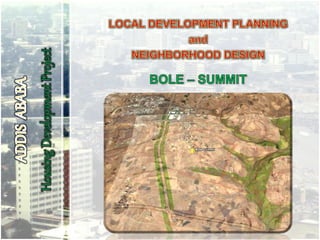
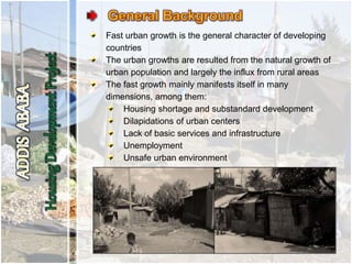
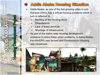
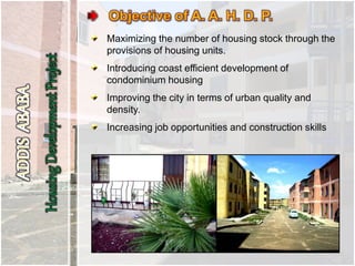
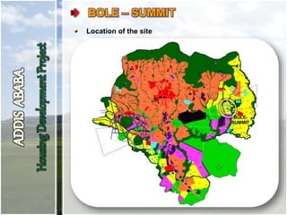
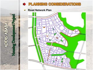
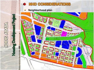
Fast urban growth is the general character of developing
countries
The urban growths are resulted from the natural growth of
urban population and largely the influx from rural areas
The fast growth mainly manifests itself in many
dimensions, among them:
Housing shortage and substandard development
Dilapidations of urban centers
Lack of basic services and infrastructure
Unemployment
Unsafe urban environment
Addis Ababa, as one of the fast growing cities in sub-
Saharan Africa, has a critical housing problems which in
turn is reflected in:
Backlog of the housing stock
Dilapidations
Lack of basic services
Shortage of infrastructure
As part of the nation wide housing development
endeavor to solve these urban problems, in Addis Ababa,
the AAHDPO was formed and Condominium Housing
was introduced.
Maximizing the number of housing stock through the
provisions of housing units.
Introducing coast efficient development of
condominium housing
Improving the city in terms of urban quality and
density.
Increasing job opportunities and construction skills
The AAHDPO is leading the construction of several
condominium housing project sites, while some are being
completed such as the recently inaugurated Mickey
Leyland site.
Several new project sites are also being designed
Our office, Consulting Architects and Engineers,
has been working on the LDP and NHD of Bole –
Summit site closely with AAHDP Office through multiple
presentations and discussions.
Consulting Architects and Engineers.
Comprises professionals in the areas of:
Urban Planning and Design
Architecture
Engineering, and
Construction Technology and Management
Previous experiences in Urban Planning and Design:
Adama Master Plan Revision Project
Tisabay Town Base Plan
LDP and NHD for
Jemo-II and Jemo-II Extension in Addis Ababa
11 towns in ONRS
7 towns in SNNPRS
Jemo – II Land Use
Assignments of the consultant:
Conducting topographic assessments
Existing situation analysis
Preparation of Local Development Plan
Design of the Neighborhood
Preparation of design documents and detailed
implementation tools
Location of the site
BOLE-
SUMMIT
Bole – Summit on Addis Ababa Land Use Plan
THE SITE
Located in the East of Addis Ababa, to the South of Summit
Factory
The site is bounded by three arterial streets and natural
gorges that penetrated into the site like fingers:
North: Secondary ring road
West: Road to CMC sub-center
South: Road to existing ring road at Bole
East: natural gorges
General slope of the site varies from 1% to >15%
The natural green gorges, the park strips along the west
arterial street and the surrounding of the site are important
scenic features.
The top soil of the site and its surrounding is black cotton
soil.
THE SITE
At the northern periphery of the site, along the secondary
ring road, a regulated but partially informal settlement is
found. Some farmer houses are also found scattered on
the site.
Around the north-western part of the site two worship
centers, an Orthodox Church (with adjacent burial ground)
and a Waqe-fenna, are found.
Navigation Radio Transition Antenna (Beacon) is located at
the north-eastern part of the site.
Satellite image of the site
Existing Infrastructural features
Slope Analysis
Gorge
Gorge
Gorge
Surrounding Green
Asphalted Road along the western edge of the site
Existing Regulated Settlement
Existing Farmers Houses
Navigation Radio Transition Antenna (Beacon)
Bridge on the North-astern Corner (U. C.)
The provisions and regulations of Revised Addis
Ababa Master Plan relevant documents to asses
the structure, services distribution, connections,
access provision, etc. of the city and in particular the
surrounding of the given site – Bole-summit
The housing neighborhood planning and design
manual
Topographic maps: Nortech, Israeli & Dev’t Partners
The given architectural typology designs of the
housing blocks
Previously finalized LDPs and NHDs for the Housing
Development Project
Other planning and design reference books
Size and shape of the site
Access and outlets
Topography and land cover
Structure Plan of Addis Ababa and its documents
Existing settlements and infrastructure
Existing service locations and their accessibility
Connection to major centers of the city and
surrounding nodes of services
Environmental Issues
Safety and livability
Connection to surrounding nodes of services
Concept Plan
Livable Neighborhood
Hierarchy of Open spaces
Adequate parking space
Adapting to the topography
Clearly defined neighborhood centers
Resettlement possibility for existing settlers
Well mixed and balanced land use
Consideration for commercial hot spots
Social mix (based on income group)
20% Studios (low income)
40% One bedroom (low-middle income)
20% Two bedroom (middle income)
10% Three bedroom (high-middle income)
10% Commercial units
Social services and facilities for Kebele-01
No. Services and Facilities Number of units
1 Health center 1
2 Kindergarten 24
3 Primary school 4
4 Secondary school 2
5 TEVT and Preparatory 2
6 Administrative and cultural
center
1
7 Sport and recreation center 1
Proposed Land Use
Utilities and Services
Connection to municipal sewer system
Provision of communal garbage collection points
Consideration of norms and standards for each type
of services
Roads and their hierarchy
Collector street- 1: 30m
Collector street- 2: 21m
Collector street- 3: 16m
Local Street : 10m
Pedestrian way- 1: 4m
Pedestrian way- 2: 2m (within parcel)
Road Network Plan
Clearly defined and accessible site blocks
Formation of smaller (manageable) and integrated
communities by arranging buildings within a
compound defined by local and collector roads
Security and sense of privacy
Up keeping and managing shared facilities like: green
areas, walkways, car parking areas, common facility
building blocks
Pedestrianizing the compound
Separation of vehicular circulations from communal
open spaces
Safety of each parcel blocks
Clean and livable environment
Communicative
Arrangement of blocks
Street definition
Definition of meaningful communal space
Accessibility
Density
Open spaces
Hierarchy of the communal green
Communal internal green
Pedestrian access to internal open spaces
Topography
Adaptation to the major features of the site
Slope analysis
Selecting topography suitable for cost-efficient
housing
Raising of the ground floor level by 30 cm (from
higher point)
Setbacks
2.5 – 3m from street
2.0m between walkway and building
8.0m between windows of buildings
4.0m minimum between buildings
Parking
Residents: one parking for five households (onsite)
Commercial parking is provided mainly along collector
streets.
Provision of Coordinates and Dimensions
All necessary dimensions
Coordinates for collector and local street centers
Coordinates for the structural axis intersection of the
buildings
Building typologies
M1
T18
T16 T4
Neighborhood plan
3D of site blocks
NHD detail drawing
NHD detail drawing
Dimensions and coordinates
3D of site blocks and their elements
Car parking
Communal open space within a parcel
AAHDP_BOLE-SUMMIT Presentation Nove 5.pptx

AAHDP_BOLE-SUMMIT Presentation Nove 5.pptx

  • 2.
    Fast urban growthis the general character of developing countries The urban growths are resulted from the natural growth of urban population and largely the influx from rural areas The fast growth mainly manifests itself in many dimensions, among them: Housing shortage and substandard development Dilapidations of urban centers Lack of basic services and infrastructure Unemployment Unsafe urban environment
  • 3.
    Addis Ababa, asone of the fast growing cities in sub- Saharan Africa, has a critical housing problems which in turn is reflected in: Backlog of the housing stock Dilapidations Lack of basic services Shortage of infrastructure As part of the nation wide housing development endeavor to solve these urban problems, in Addis Ababa, the AAHDPO was formed and Condominium Housing was introduced.
  • 4.
    Maximizing the numberof housing stock through the provisions of housing units. Introducing coast efficient development of condominium housing Improving the city in terms of urban quality and density. Increasing job opportunities and construction skills
  • 5.
    The AAHDPO isleading the construction of several condominium housing project sites, while some are being completed such as the recently inaugurated Mickey Leyland site. Several new project sites are also being designed Our office, Consulting Architects and Engineers, has been working on the LDP and NHD of Bole – Summit site closely with AAHDP Office through multiple presentations and discussions.
  • 6.
    Consulting Architects andEngineers. Comprises professionals in the areas of: Urban Planning and Design Architecture Engineering, and Construction Technology and Management Previous experiences in Urban Planning and Design: Adama Master Plan Revision Project Tisabay Town Base Plan LDP and NHD for Jemo-II and Jemo-II Extension in Addis Ababa 11 towns in ONRS 7 towns in SNNPRS
  • 7.
    Jemo – IILand Use
  • 8.
    Assignments of theconsultant: Conducting topographic assessments Existing situation analysis Preparation of Local Development Plan Design of the Neighborhood Preparation of design documents and detailed implementation tools
  • 9.
    Location of thesite BOLE- SUMMIT
  • 10.
    Bole – Summiton Addis Ababa Land Use Plan
  • 11.
    THE SITE Located inthe East of Addis Ababa, to the South of Summit Factory The site is bounded by three arterial streets and natural gorges that penetrated into the site like fingers: North: Secondary ring road West: Road to CMC sub-center South: Road to existing ring road at Bole East: natural gorges General slope of the site varies from 1% to >15% The natural green gorges, the park strips along the west arterial street and the surrounding of the site are important scenic features. The top soil of the site and its surrounding is black cotton soil.
  • 12.
    THE SITE At thenorthern periphery of the site, along the secondary ring road, a regulated but partially informal settlement is found. Some farmer houses are also found scattered on the site. Around the north-western part of the site two worship centers, an Orthodox Church (with adjacent burial ground) and a Waqe-fenna, are found. Navigation Radio Transition Antenna (Beacon) is located at the north-eastern part of the site.
  • 13.
  • 14.
  • 15.
  • 16.
  • 17.
  • 18.
  • 19.
  • 20.
  • 21.
    Asphalted Road alongthe western edge of the site
  • 22.
  • 23.
  • 24.
  • 25.
    Bridge on theNorth-astern Corner (U. C.)
  • 26.
    Bridge on theNorth-astern Corner (U. C.)
  • 27.
    The provisions andregulations of Revised Addis Ababa Master Plan relevant documents to asses the structure, services distribution, connections, access provision, etc. of the city and in particular the surrounding of the given site – Bole-summit The housing neighborhood planning and design manual Topographic maps: Nortech, Israeli & Dev’t Partners The given architectural typology designs of the housing blocks Previously finalized LDPs and NHDs for the Housing Development Project Other planning and design reference books
  • 28.
    Size and shapeof the site Access and outlets Topography and land cover Structure Plan of Addis Ababa and its documents Existing settlements and infrastructure Existing service locations and their accessibility Connection to major centers of the city and surrounding nodes of services Environmental Issues Safety and livability
  • 29.
    Connection to surroundingnodes of services
  • 30.
  • 31.
    Livable Neighborhood Hierarchy ofOpen spaces Adequate parking space Adapting to the topography Clearly defined neighborhood centers Resettlement possibility for existing settlers Well mixed and balanced land use Consideration for commercial hot spots Social mix (based on income group) 20% Studios (low income) 40% One bedroom (low-middle income) 20% Two bedroom (middle income) 10% Three bedroom (high-middle income) 10% Commercial units
  • 32.
    Social services andfacilities for Kebele-01 No. Services and Facilities Number of units 1 Health center 1 2 Kindergarten 24 3 Primary school 4 4 Secondary school 2 5 TEVT and Preparatory 2 6 Administrative and cultural center 1 7 Sport and recreation center 1
  • 33.
  • 34.
    Utilities and Services Connectionto municipal sewer system Provision of communal garbage collection points Consideration of norms and standards for each type of services Roads and their hierarchy Collector street- 1: 30m Collector street- 2: 21m Collector street- 3: 16m Local Street : 10m Pedestrian way- 1: 4m Pedestrian way- 2: 2m (within parcel)
  • 35.
  • 36.
    Clearly defined andaccessible site blocks Formation of smaller (manageable) and integrated communities by arranging buildings within a compound defined by local and collector roads Security and sense of privacy Up keeping and managing shared facilities like: green areas, walkways, car parking areas, common facility building blocks Pedestrianizing the compound Separation of vehicular circulations from communal open spaces Safety of each parcel blocks Clean and livable environment Communicative
  • 37.
    Arrangement of blocks Streetdefinition Definition of meaningful communal space Accessibility Density Open spaces Hierarchy of the communal green Communal internal green Pedestrian access to internal open spaces Topography Adaptation to the major features of the site Slope analysis Selecting topography suitable for cost-efficient housing Raising of the ground floor level by 30 cm (from higher point)
  • 38.
    Setbacks 2.5 – 3mfrom street 2.0m between walkway and building 8.0m between windows of buildings 4.0m minimum between buildings Parking Residents: one parking for five households (onsite) Commercial parking is provided mainly along collector streets. Provision of Coordinates and Dimensions All necessary dimensions Coordinates for collector and local street centers Coordinates for the structural axis intersection of the buildings
  • 39.
  • 40.
  • 41.
    3D of siteblocks
  • 42.
  • 43.
  • 44.
  • 45.
    3D of siteblocks and their elements
  • 46.
  • 47.
    Communal open spacewithin a parcel