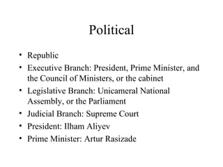
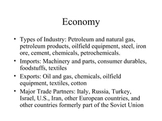
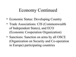
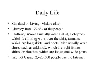
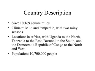
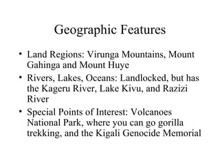
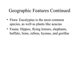
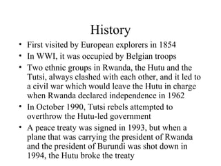
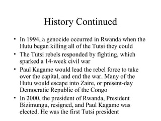
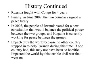
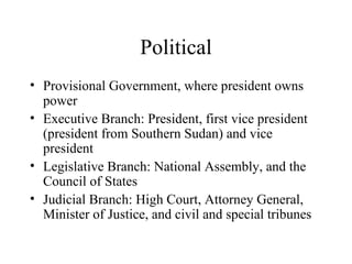
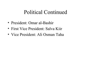
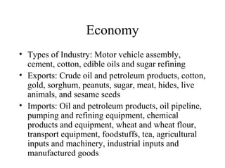
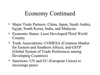
Country Project By: Steven Ferrigno
Azerbaijan
Country Map
Country Description Size: 33,774 square miles Climate: Dry, subtropical with hot summers and mild winters Location: In Asia, with Russia to the North, the Caspian Sea to the East, Iran to the South, and Georgia and Armenia to the West Population: 9,022,000 people
Geographic Features Land Regions: Caucasus mountain range, Talysh Mountains, Kura-Aras lowlands Rivers, Lakes, Oceans: Borders the Caspian Sea, Mtkvari River, which is the longest in Azerbaijan, and the Mingechaur Reservoir Special Points of Interest: Baku, one of the most beautiful cities in the world, Tenghi Canyon, Afurdzhin Waterfall, and Sheki, with palaces that are converted to hotels
Geographic Features Continued Flora: Very rich, more than 4,500 species because of the fertile area that it’s located in. Species include Russian knapweed and fringed water lilly Fauna: The Karabakh horse, which can only be found in Azerbaijan, goats, gazelles, salmoon, eel, and the golden eagle
Vacation Tour You would arrive in Baku, and explore the city. Then, you would go to a city and see Guba Mosques and other features. From there, you would go to Nakhchivan, and see the beautiful city and its healing spring. From there, you would visit Kars, where you would see the fortresses there.The last stop before departing from Baku would be to go to Kazbegi, and see the northern slopes of the Caucasus Mountains.
History Conquered by Arabs in 642 AD After decline of Arab Empire, was conquered by Mongol invasions Fought over by many countries because of its location on the Caspian Sea Split between Russia and Persia in 1828 by Treaty of Turkmenchay Oil fields found in Azerbaijan led to a time of prosperity in 1870s After WWI and the collapse of the Russian Empire in 1917, became a democratic republic
History Continued Recognized by the Allies as an independent nation in 1920 Became a part of U.S.S.R in 1936 Declared independence from U.S.S.R on August 30, 1991 Impacted by world after WWI, because that was when Russia broke apart, and it became an independent nation for the first time Current Event: In February 2011, activists demanding a change in government were arrested and thrown in jail. It looks like the revolution in Egypt is not only spreading to Libya, but also to nearby countries, and may result in a change of government for Azerbaijan.
Political Republic Executive Branch: President, Prime Minister, and the Council of Ministers, or the cabinet Legislative Branch: Unicameral National Assembly, or the Parliament Judicial Branch: Supreme Court President: Ilham Aliyev Prime Minister: Artur Rasizade
Economy Types of Industry: Petroleum and natural gas, petroleum products, oilfield equipment, steel, iron ore, cement, chemicals, petrochemicals. Imports: Machinery and parts, consumer durables, foodstuffs, textiles Exports: Oil and gas, chemicals, oilfield equipment, textiles, cotton Major Trade Partners: Italy, Russia, Turkey, Israel, U.S., Iran, other European countries, and other countries formerly part of the Soviet Union
Economy Continued Economic Status: Developing Country Trade Associations: CIS (Commonwealth of Independent States), and ECO (Economic Cooperation Organization) Sanctions: Sanction on arms by all OSCE (Organization on Security and Co-operation in Europe) participating countries
Daily Life Standard of Living: Middle class Literacy Rate: 99.5% of the people Clothing: Women usually wear a shirt, a chepken, which is clothing worn over the shirt, turmans, which are long skirts, and boots. Men usually wear shirts, such as arkhaluk, which are tight fitting shirts, or chukhas, which are loose, and wide pants Internet Usage: 2,420,000 people use the Internet
Culture Traditions: Novruz is celebrated, which is where the people say goodbye to the Old Year and welcome in the New Year with four pre-holiday Wednesdays where the people try make things new. Everyone in the family participates Customs: The family is the most important element. It is a very hierarchal society. People also tend to for the needs of their family and tradition over any set laws. People in Azerbaijan also tend to have many superstitions Religions: Mostly Islamic, with some Armenian Orthodox and Russian Orthodox
Culture Continued Foods: Many unique foods that have been passed from generation to generation, such as soups, meat kebabs, sheep meat, dried fruit, and walnuts Music/Dance: Folk dances that are very old, usually done at celebrations. Music has a fast rhythm, and is played mostly with string instruments
Unique Facts/Places Every year in Goychay, there is a pomegranate festival, where there is dancing, music, and of course, pomegranates The main language is Azerbaijani, but people also speak English and Russian The currency there is the Marat The capital is Baku It is the largest and most populous country in the South Caucasus region
Conclusion Azerbaijan is a small, yet important country. It sells many of the resources that the United States needs to survive, and so it is a developing country. It isn’t a very old country, and has only been independent for a few years. I found the most interesting thing to be that they have their own type of clothing, and they don’t just wear western-style clothing.
Montenegro
Country Map
Country Description Size: 5,381 square miles Climate: Generally continental; Mediterranean along the coast Location: In Europe, with Bosnia and Herzegovina to the North, Serbia and Kosovo to the East,  the Adriatic Sea to the West, and Albania to the South Population: 630,548 people
Geographic Features Land Regions: Mount Lovcen, Mount Orjen, Zeta River Valley, and Tara River Canyon Rivers, Lakes, Oceans: borders Adriatic Sea, Skadar Lake (largest lake), Bay of Kotor, and part of Danube River passes through Special Points of Interest: Tara River Canyon, which is a popular rafting spot, remains of the ancient city of Duklja, and Biogradska Gora, which is a national park and Europe’s only virgin forest
Geographic Features Continued Flora: 2,833 types, which makes up almost a quarter of European flora. Includes white water lillies, bamboo, and orchids Fauna: Deer, hare, fox, wild boar, crane, duck, and goose
Vacation Tour First, you would land in Podgorica, where you would go sightseeing in this beautiful city. Then, you would go to the Tara Canyon, which is the deepest canyon in Europe and a famous river rafting spot. You would then visit the Skadar Lake, which has a large variety of flora and fauna. Finally, before leaving, you should visit Ostrog and see the monastery there. It is carved into rocks, and it is such a big structure that you’ll have trouble believing that it was built by humans.
History Resisted rule of Ottoman Turks and was recognized as an independent nation by the Congress of Berlin in 1878 Fought on side of Allies in WWI, but was defeated and then taken over by Austria Serbians killed king of Montenegro in 1918, and declared unification with Serbia; was part of Kingdom of Yugoslavia from 1919 to 1941 When Axis powers invaded Yugoslavia in 1941, Montenegro was freed Declared a republic inside Yugoslavia after the war Yugoslav federation broke up in 1989, and Montenegro, Serbia, and Belgrade passed the Constitution of the Federal Republic of Yugoslav
History Continued In 2003, the Constitutional Charter was ratified, which changed the name of the country from Yugoslavia to Serbia and Montenegro On June 3, 2006, Montenegro declared independence from Serbia Impacted by WWI when it was taken over by Austria, and WWII, when it was freed and declared a republic Current Event: In December 2010, Prime Minister Milo Djukanovic stepped down from his job because he felt as though he had led the nation closer to becoming part of the European Union. Milo was influential in helping Montenegro separate from Serbia, and he will be missed.
Political Republic Executive Branch: President and Prime Minister Legislative Branch: Parliament Judicial Branch: Constitutional Court and Supreme Court President:Filip Vujanovic Prime Minister: Igor Luksic
Economy Types of Industry: Steelmaking, agricultural processing, consumer goods, tourism Exports: Manufactured goods, food, live animals and raw materials Imports: Machinery and transport equipment, fuels and lubricants, and manufactured goods Major Trade Partners: Italy, Greece, Slovenia, Hungary, and Germany Economic Status: Developing Country Trade Associations: None Sanctions: None
Daily Life Standard of Living: Recovering Literacy Rate: 93% of the people Clothing: Most people dress in Western style clothing, such as shirts and jeans for men and skirts and blouses for women Internet Usage: 280,000 people use the Internet
Culture Traditions: One traditions is the Sota dance, which is performed between a man and woman at a wedding, and is very fast. Epic songs are often played at many events, which are music played reciting stories of past heroes and telling of their accomplishments Customs: Culture often revolves around clans. Families are very close, and many generations often live together under one roof. The first born son inherits the money  Religions:Orthodox Christian, Catholicism, and Islamic
Culture Continued Foods: Influenced by Italian food, like meatballs and soups, and Hungarian dishes like goulash. Seafood is also a common dish Music/Dance: Classical music, as well as choir music is enjoyed. One popular dance is the Oro dance, where people form a circle and sing, and people jump in and dance
Unique Facts/Places The capital is Podgorica It is slightly smaller than Connecticut The official language is Montenegrin, but people also speak Serbian, Bosnian, or Albanian Montenegro translates in Montenegrin to mean “Black Mountain”  The currency used is the Euro
Conclusion Montenegro is still developing, and seems to be fighting with its neighbors a lot. This isn’t a good thing. It is a beautiful place to travel, and I would like to go there. The thing I found most interesting was the fact that it has only been independent for a few years, and it is trying to make a name for itself.
Rwanda
Country Map
Country Description Size: 10,169 square miles Climate: Mild and temperate, with two rainy seasons Location: In Africa, with Uganda to the North, Tanzania to the East, Burundi to the South, and the Democratic Republic of Congo to the North and West Population: 10,700,000 people
Geographic Features Land Regions: Virunga Mountains, Mount Gahinga and Mount Huye Rivers, Lakes, Oceans: Landlocked, but has the Kageru River, Lake Kivu, and Razizi River Special Points of Interest: Volcanoes National Park, where you can go gorilla trekking, and the Kigali Genocide Memorial
Geographic Features Continued Flora: Eucalyptus is the most common species, as well as plants like acacias Fauna: Hippos, flying lemurs, elephants, buffalo, lions, zebras, hyenas, and gorillas
Vacation Tour First, you would arrive in the capital city of Kigali, where you would see it as being the commercial center of Rwanda. Then, you would go and see the Virunga Volcanoes, which are still active. Then, you would visit Kagera National Park, near Kibungu. It has many lakes and waterfalls. Finally, before heading back to Kigali to go home, you would visit Butare, which is the intellectual city of the country and has a museum and a botanical garden.
History First visited by European explorers in 1854 In WWI, it was occupied by Belgian troops Two ethnic groups in Rwanda, the Hutu and the Tutsi, always clashed with each other, and it led to a civil war which would leave the Hutu in charge when Rwanda declared independence in 1962 In October 1990, Tutsi rebels attempted to overthrow the Hutu-led government A peace treaty was signed in 1993, but when a plane that was carrying the president of Rwanda and the president of Burundi was shot down in 1994, the Hutu broke the treaty
History Continued In 1994, a genocide occurred in Rwanda when the Hutu began killing all of the Tutsi they could The Tutsi rebels responded by fighting, which sparked a 14-week civil war Paul Kagame would lead the rebel force to take over the capital, and end the war. Many of the Hutu would escape into Zaire, or present-day Democratic Republic of the Congo In 2000, the president of Rwanda, President Bizimungu, resigned, and Paul Kagame was elected. He was the first Tutsi president
History Continued Rwanda fought with Congo for 4 years Finally, in June 2002, the two countries signed a peace treaty In 2003, the people of Rwanda voted for a new constitution that would balance the political power between the two groups, and Kagame is currently working for peace between the groups Impacted by the world because no other country stepped in to help Rwanda during this time. If one country had, this may not have been so horrific. Impacted the world by this terrible civil war that went on
History Continued Current Event: In February 2011, leaders of African countries met in Rwanda to discuss how to make their individual countries better, in a meeting called the African Capacity Building Foundation. This is good for Rwanda not only for the business it brings in, but also because Rwanda has to fix its country after the terrible genocide, and the Rwandan leaders might get some ideas on how to do that from this meeting.
Political Republic Executive Branch: President and Prime Minister Legislative Branch: Bicameral Parliament, with Chamber of Deputies and the Senate Judicial Branch: Supreme Court President: Paul Kagame Prime Minister:  Bernard Makuza
Economy Types of Industry: Cement, agricultural products, small-scale beverages, soap, furniture, shoes, plastic goods, textiles, cigarettes Exports: Coffee, tea, hides, tin ore Imports: Foodstuffs, machinery and equipment, steel, petroleum products, cement and construction material Major Trade Partners: Kenya, Germany, USA, and Belgium Economic Status: Developing Country
Economy Continued Trade Associations: AGOA (African Growth and Opportunity Act), and COMESA ( Common Market for Eastern and Southern Africa) Sanctions: None
Daily Life Standard of Living: Poor Literacy Rate: 70.4% of the people Clothing: Most people wear Western-style clothing. However, they buy it at used clothing stores. Traditional Rwadan costumes made of animal skins are only seen in museums Internet Usage: 450,000 people use the Internet
Culture Traditions: National Mourning Day, which is celebrated to remember all of the people who lost their lives in the Rwandan genocide Customs: Jobs are given out to people according to gender. Also, men are considered more important in Rwanda, and therefore are given the inheritance when the head of household dies Religions: Catholic, Protestant, Seventh-day Adventist, and Muslim
Culture Continued Foods: Agricultural food, such as bananas, sweet potatoes, and beans. Milk is commonly drunk, but meat is rarely eaten Music/Dance: Important part of culture. Happens at ceremonies and social gatherings. The most famous dance is Intore, which consists of a ballet, a dance of heroes, and playing of the drums. The most popular genres are hip-hop, dance-pop, and R&B. Drums also are played a lot
Unique Facts/Places The capital is Kigali Rwanda is also known as the Land of a Thousand Hills The currency is the Rwandan franc Homosexuality is legal in Rwanda The average life expectancy in Rwanda is very low: only 40 years The official languages are Kinyarwanda, French, and English
Conclusion Rwanda is not a very good place to live right now. It is having trouble ever since the genocide that occurred there. The literacy rate isn’t very high, but the people in Rwanda are working very hard to improve the standard of living. The thing that I found most interesting is that the life expectancy is only 40 years, which is very low. This is a sad thing to hear.
Serbia
Country Map
Country Description Size: 29,912 square miles Climate:In the north, continental climate; central portion, continental and Mediterranean climate; to the south, hot, dry summers and autumns and relatively cold winters with heavy snowfall inland Location: In Europe, with Hungary to the North, Bosnia and Herzegovina, Croatia, and Montenegro to the west, Romania to the East, and Kosovo to the South Population: 7,478,820 people
Geographic Features Land Regions: Dinaric Alps, Carpathian Mountains, Balkan Mountains, and the Morava river valley Rivers, Lakes, Oceans: Landlocked, but has the Danube River, and the Morava River Special Points of Interest: Zlatibor, which is a mountainous tourist site and ski resort, Pozarevac, one of the oldest cities in Serbia, and Kragujecvac, which is the industrial hub of Serbia
Geographic Features Continued Flora: Rosy garlic, Aquilegia grata, which is a type of perennial, and Macedonian pines Fauna: Brown bears, mice, jackal, wolves, moles, bats, white-tailed eagles, and ducks
Vacation Tour You would first land in Belgrade, where you can explore the capital city and see the industrial hub of Serbia. Then, you should explore the Danube River, which has the huge Kalemegdan fortress right by it. It is over 2,000 years old, and a great tourism spot. If you’re into history, you should also check out the city of Smederevo, which has a lot of medieval artifacts. Finally, before you go, you should visit some ancient monasteries, like Zica and Studenica, which show off Serbia’s history.
History First Serbian kingdom was created in 1170 AD by Stefan Nemanja Territory expanded under the rule of King Milutin In 1459, however, Serbia was losing power, and the Ottoman empire took control over all Serbian lands Ruled by the empire for 370 years, until some people began leading rebellions After waging war against Turkey in 1876, Serbia gained independence in 1878 Serbia seized the rest of the Ottoman Empire in 1913 with help from Montenegro, Bulgaria, and Greece
History Continued The assassination of Austria archduke Franz Ferdinand on June 28, 1914, by a Serbian, would set off WWI Austria, Hungary, and Bulgaria took over Serbia during WWI After Austria-Hungary broke up after WWI, Serbia, Vojvodina, and Montenegro united to form a country named Yugoslavia During WWII, Yugoslavia was occupied by Axis powers, and royal army soldiers tried to form a Serbian resistance movement that was put down In 1980, when Yugoslavian ruler Josip Tito died, the economy started to fail
History Continued This led to unrest by many of the countries, and in 1991 and 1992, Slovenia, Croatia, Bosnia and Herzegovina, and Macedonia seceded from Yugoslavia In 1992, Serbia and Montenegro passed the Constitution of the Federal Republic of Yugoslavia Fighting broke out between Serbia and Kosovo when Kosovo tried to declare independence In 2003, the Constitutional Charter was passed, which changed the country’s name from Yugoslavia to Serbia and Montenegro In 2006, Montenegro declared independence from Serbia
History Continued Kosovo declared independence from Serbia in 2008, but Serbia doesn’t recognize it as an independent nation Impacted the world by starting the first WW, and fighting with Kosovo, which led to the UN stepping in to help. Impacted by the world when it was occupied by countries during both of the world wars Current Event: In March 2011, Serbia decided to  stop selling wheat to other countries in order to boost domestic sales. This, however, hurts other countries around Serbia, like Montenegro, and may even lead to fighting for the wheat.
Political Republic Executive Branch: President, Prime Ministers, and Council of Ministers Legislative Branch: Parliament Judicial Branch: Supreme Court of Cassation and Constitutional Court President: Boris Tadic Prime Minister: Mirko Cvetkovic
Economy Types of Industry: Base metals, furniture, food processing, machinery, chemicals, sugar, tires, clothes, pharmaceuticals Exports: Iron and metal, non-ferrous metals, electrical machines, cereals, and vegetables Imports: Oil, natural gas, types of metals Major Trade Partners:Italy, Germany, Austria, Greece, France, and Slovenia
Economy Continued Economic Status: Developing Country Trade Associations: None Sanctions: None
Daily Life Standard of Living: Recovering Literacy: 96.4% of the people Clothing: Most people dress in Western style clothing, like T-shirts, jeans, and dresses Internet Usage: 4,107,000 people use the Internet
Culture Traditions: Slava is a tradition where each family honoring a saint’s feast day and then considers that saint that particular family’s protector  Customs: On Christmas, there is a tradition where each family cuts down their tree on Christmas Day, then has a main meal. On Easter, Serbs celebrate with the tradition of Slavic Egg decorating Religions: The most common is Orthodox Christianity. Also has Christianity, Protestant Islam, and Jews
Culture Continued Foods: Influenced by Meditteranean and Oriental cuisine, like jam, jelly, sausage, sauerkraut, spices, and many meat dishes Music/Dance: Folk music, and well as rock and pop music. Traditional dance is the Kolo, which is where a group of people form a circle and hold hands and dance
Unique Facts/Places The capital is Belgrade The majority of people in Serbia are Serbian The official language is Serbian, but people also speak Hungarian, Slovak, and Croatian The currency of Serbia is the Serbian Dinar Belgrade is one of the oldest cities in Europe, and was settled in the 3rd century BC
Conclusion Serbia is a very old country. It has been around for a long time, and has been at the center of world history ever since World War I. I found it interesting that as long as Serbia has been around, it has not been independent for very long, and it is still trying to make a name for itself.
Sudan
Country Map
Country Description Size: 967,500 square miles Climate: Desert and savanna in the north and central regions and tropical in the south Location: In Africa, with Egypt to the North, Ethiopia to the East, Chad and Libya to the West, and Uganda, Kenya, and the Democratic Republic of Congo to the South  Population: 41,087,825 people
Geographic Features Land Regions: Nubian Desert, Libyan Desert, Nile Valley, and the Ironstone Plateau Rivers, Lakes, Oceans: Borders the Red Sea,  Dindar River, Rahad River, Qash River, and the Sudd, the world’s largest swamp Special Points of Interest: The Red Sea, Khartoum, who’s National Museum has many old treasures, and Dinder National Park, which has many species of animals and is one of the largest in the world
Geographic Features Continued Flora: Acacia, desert shrub, and acacia short grass grow in the desert, and date palms grow along the Nile River Fauna: Hippos, crocodiles, giraffes, leopards, many types of monkeys, migratory birds, and insects such as the tsetse fly
Vacation Tour You would arrive in Khartoum, and explore all of the museums in the capital. Then, you would drive to Kawa and all of the ancient temples that are located there. You would then visit the Mahila Desert and explore the tombs of some ancient kings. After that, you would visit the city of Meroe, which is a very important trade city. Finally, before leaving from Khartoum, you would make a stop at Naqaa, which has some interesting sanctuaries and palaces.
History Collection of small, independent kingdoms until conquered and united by Egypt in 1820-1821 Man named Muhammad ibn Abdalla unified the tribes of Sudan in 1881 and took over the government until 1898 Conquered by Britain and Egypt in 1898 First parliament established in 1954 Declared independence in 1956 Constitution led to anger because it didn’t cover Islamic rights Led to a civil war between the Arab and Islamic (who were in the South) people that started in 1956
History Continued Led to a civil war between the Arab (who were in the North) and Islamic (who were in the South) people that started in 1956 Power was switched between many rulers over many years who battled to provide the rights everyone deserved The ruler at the time, Gaafar Nimeiri, decided to sign a peace treaty with the rebels in 1972. This would end the civil war However, the peace was shattered when Nimeiri declared Arabic the official language in 1983 The second Sudan war then began
History Continued A civilian government took over in 1986, but fighting still went on Finally, in 2002, talks were held between the two sides in the nation of Kenya On December 31, 2004, the two sides signed a peace treaty that is still holding up today Impacted the world by the fact that many different nations had to step in in order to make this treaty come together, and to stop this long war. Thankfully, this treaty is still effective today
History Continued Current Events: Over the past few years, there has been a vicious genocide in Darfur of non-Arab Sudanese people by Sudanese Arabs. This has been going on since 2003, and things haven’t gotten much better. There have been talks of peace, and Darfur might be broken up into two separate states in order to end the fighting.
Political Provisional Government, where president owns power Executive Branch: President, first vice president (president from Southern Sudan) and vice president Legislative Branch: National Assembly, and the Council of States Judicial Branch: High Court, Attorney General, Minister of Justice, and civil and special tribunes
Political Continued President: Omar al-Bashir First Vice President: Salva Kiir Vice President: Ali Osman Taha
Economy Types of Industry: Motor vehicle assembly, cement, cotton, edible oils and sugar refining Exports: Crude oil and petroleum products, cotton, gold, sorghum, peanuts, sugar, meat, hides, live animals, and sesame seeds Imports: Oil and petroleum products, oil pipeline, pumping and refining equipment, chemical products and equipment, wheat and wheat flour, transport equipment, foodstuffs, tea, agricultural inputs and machinery, industrial inputs and manufactured goods
Economy Continued Major Trade Partners: China, Japan, Saudi Arabia, Egypt, South Korea, India, and Malaysia Economic Status: Least Developed/Third World Country Trade Associations: COMESA (Common Market for Eastern and Southern Africa), and GSTP (Global System of Trade Preferences among Developing Countries) Sanctions: UN and EU (European Union) to encourage peace
Daily Life Standard of Living: Poor Literacy Rate: 61.1% of the people Clothing: Many people wear either traditional or western clothes. Two common outfits are the jalabiya, which is a long-sleeved garment, or the thawb, which is like a tunic Internet Usage: 4,200,000 people use the Internet
Culture Traditions: Ramadan, which is a month of fasting in order to purify yourself. After the month, they celebrate Eid ul-Fitr, which marks the end of Ramadan, and is a time of feasting and celebration Customs: Women take care of the home, while men go off to work. Only 29% of the workforce is female. Sudan is a patriarchal society, and women have a lesser status then men. However, both men and women receive educations. The family lives close together, including relatives Religions: Islam, Catholic, Anglican
Culture Continued Food: Tea is often drunk. A food called millet is one of the most important foods, and is often eaten in porridges. Many vegetables stews and salads are eaten, and meat is so expensive that it is rarely eaten Music/Dance: Folk music that reflects the customs of an area, as well as hip-hop and jazz
Unique Facts/Places The capital is Khartoum The official languages are Arabic and English, but people also speak Dinka, Nuer, Acholi, and Lango The currency is the Sudanese dinar No credit cards can be used in Sudan because of the US embargo It is the largest country in all of Africa
Conclusion Sudan is not the best place to live in, especially if you are a woman. Women aren’t given the respect they deserve. The literacy rate is very low, and the standard of living is poor, mostly because of the genocides in Darfur that have torn the country apart. I found it interesting to see all of the civil wars that Sudan has been a part of. It is a sign that something needs to change fast.
Trinidad and Tobago
Country Map
Country Description Size: 1,980 square miles Climate: Tropical; principal rainy season is June through December Location: Two islands in the Caribbean, with South America to the South, and Central America to the West Population: 1,303,188 people
Geographic Features Land Regions: Trinidad has three mountain ranges called the Northern Range, the Central Range, which goes diagonally across the island, and the Southern Range. Tobago has a range called the Main Ridge, and fertile valleys that are located right near that Rivers, Lakes, Oceans: It’s an archipelago surronded by the Atlantic Ocean, the Caribbean Sea, and the Gulf of Paria. Also has the Ortoire River and the Caroni River
Geographic Features Continued Special Points of Interest: The Asa Wright Nature Center in Trinidad, where you can see many different species of birds, and the Fort King George in Tobago, which has many old monuments Flora: Small trees, ferns, herbs, papayas, and mangos Fauna: Vampire bats, ocelots, raccoon, otters, armadillo, and opossums, and many species of birds
Vacation Tour You would land in Port-of-Spain in Trinidad, and would explore the city. Then, you would go to the Hills of Paramin, where many different types of flora grow. Then, you would go birdwatching at the Caroni Bird Sanctuary, where many different types of species of birds make their home. You would then fly to Tobago, where the Fort King George gives a great view of the ocean, and has many famous monuments. You should also see the Tobago Museum before heading home.
History Columbus first landed here in 1498 Spaniards settled the island in the 16th century, and wiped out the inhabitants named the Arawak and Carib Indians Remained under Spanish rule until it was captured by the British in 1797 For next 5 years, control of the islands was switched between the British, French, and Dutch 22 times until Britain gained final possession in 1803
History Continued The two islands were made into one colony in 1888 Achieved independence in 1962 and joined the British Commonwealth Became a republic in 1976 Impacted by the drive to gain as many colonies as possible, which led to the death of the native peoples Current Event: Trinidad and Tobago had the annual festival of Carnival on March 8th, which is one of the biggest pre-Lenten celebrations in the world. However, this year was disappointing this year, and people hope that new and exciting things can be introduced next year.
Political Parliamentary Democracy Executive Branch: President, and Prime Minister Legislative Branch: Bicameral Parliament Judicial Branch: Independent Court System President: George Maxwell Richards Prime Minister: Kamla Persad-Bissessar
Economy Types of Industry: Petroleum, chemicals, tourism, food processing, cement, beverage, cotton textiles Exports: Petroleum and petroleum products, ethanol, steel products, beverages, cereal and cereal products, sugar, cocoa, coffee, vegetables, flowers Imports: Mineral fuels, machinery, transportation equipment, manufactured goods, food, chemicals, live animals
Economy Continued Major Trade Partners: USA, Mexico, China, Brazil, Spain, Jamaica, Russia, and France Economic Status: Developing Country Trade Associations: CARICOM (Caribbean Community and Common Market), FTAA (Free Trade Area of the Americas), and GSTP (Global System of Trade Preferences among Developing Countries)  Sanctions: None
Daily Life Standard of Living: Poor Literacy Rate: 98.6% of the people Clothing: People usually wear Western-style clothing. However, since Trindad and Tobago is so close to the ocean, people dress for warm weather, and usually wear skirts, T-shirts, or shorts Internet Usage: 593,000 people use the Internet
Culture Traditions: A Festival called Carnival is held right before Lent. It is a parade that has elements of a circus. People dress up with masks, and it marks the overturning of daily life in preparation for Lent Customs: Women have made gains in the past years, but are still paid less than men. Women and men both get about the same amount of respect though. Males generally inherit more things. Families usually have many generations, and are very important in the culture Religions: Main groups are Catholics and Hindus, also includes Muslims, Methodists, Anglicans, and Presbyterians
Culture Continued Food: Chicken, beans, many different types of fish, potatoes, and pasta  Music/Dance: Soca, which is a type of dance music original to this country, which has fast rhythm and playing of the drums
Unique Facts and Places Along with the two main islands, the country of Trinidad and Tobago also includes the islands of Chacachacare, Monos, Huevos, Gaspar Grande, Little Tobago, and St. Giles Island The capital is Port-of-Spain The official language is English, but most people speak one of two English based languages: either Trinidadian Creole or Tobagonian Creole The currency there is the Eastern Caribbean dollar The law requires children from the ages of 5 to 16 go to school, which makes the literacy rate very high
Conclusion Trinidad and Tobago is a beautiful place to live in. The culture is placed pretty high there, as people come from all over to celebrate the annual celebration of Carnival. It is doing fairly well, and even has a higher literacy rate than the US, which is a very good sign. The most interesting thing I learned is that Christopher Columbus was the first European to discover these islands, all the way back in 1498.
Uzbekistan
Country Map
Country Description Size:172,741square miles Climate: Mid-latitude desert; long, hot summers, mild winters Location: In Asia, with Kazakhstan to the North and East, Turkmenistan to the South, and Kyrgyzstan and Tajikistan to the East Population: 28,095,000 people
Geographic Features Land Regions: Mount Adelung, Mount Beshtor, the Kyzylkum Desert, and the Greater Chimgan mountain range Rivers, Lakes, Oceans: Landlocked, but borders the Aral Sea, Amu Darya River, Syr River, and the Zeravshan River Special Points of Interest: Khiva, with many historical museums, Karakalpakstan, with its architectual and archeological sites, and Samarkand, which is the second largest city in Uzbekistan and was an important stop on the Silk Road
Geographic Features Continued Flora: More than 3,700 species, with many types of bushes and trees. Plants include onion, tulips, and rhubarb, while trees include cherry, birch, and maple Fauna:Bears, wolves, deer, salmon, trout, hedgehogs, cobras, finches, and vultures
Vacation Tour You would arrive in Tashkent, and seeing ancient buildings there. You would then go to the city of Bukhara and visit the Gazella Nature Reserve, which has many plants and animals. You would then go to the Samish Gorge, where you could see ancient ruins and rock paintings. After that, you could then go to Samarkand to take a lake tour as well as a sightseeing tour to see the city and its museums. Finally, you would go back to Tashkent and go home.
History Area conquered by Muslim Arabs in the 8th century AD Genghis Khan took over the territory in 1220 In the 1300s, a man named Timur built an empire in this region By the end of the 19th century, Russia had conquered all of Central Asia In 1924, Russia founded the Soviet Socialist Republic of Uzbekistan Mainly used for its natural resources
History Continued On September 1, 1991, Uzbekistan declared independence Impacted by Russia because it was used for its plentiful natural resources to benefit Russia Current Event: In the past couple months, representative from the US and Uzbekistan have been meeting in order to discuss cooperation between the two countries in areas like trading. This would be good for both countries, because Uzbekistan has many natural resources that the US wants, and the money that Uzbekistan receives from the US will help further Uzbekistan’s developing economy. Tourists from the US could also help improve Uzbekistan’s economy.
Political Republic Executive Branch: President, Prime Minister, and Cabinet Legislative Branch:Bicameral Supreme Assembly Judicial Branch: Supreme Court, Constitutional Court, and Economic Court President:Islam Karimov Prime Minister:Shavkat Mirziyoyev
Economy Types of Industry: textiles, food processing, machine building, metallurgy, natural gas, automobiles, chemicals Exports: Natural gas, ferrous metals, cotton fiber, food products, automobiles Imports: Machinery and equipment, chemicals, metals, foodstuffs Major Trade Partners: Russia, China, Ukraine, Switzerland, and Kazkhstan Economic Status: Developing Country
Economy Continued Trade Associations: CIS (Commonwealth of Independent States), and ECO (Economic Cooperation Organization) Sanctions: EU, in order to encourage human rights
Daily Life Standard of Living: Middle Class Literacy Rate: 99.3% of the people Clothing: Men wear shirts, and dressing gowns that cover the body and are made from cotton. Women wear dresses or dressing gowns as well Internet Usage: 4,689,000 people use the Internet
Culture Traditions: It is a tradition to drink tea in a chaikhana (tea-house) in order to find peace and serenity, and relax. It is usually located in a calming spot, and most of the time shouting or curse words are never heard when people are drinking tea in it Customs: Usually, families are very big, and respect toward elderly people in families is a must. Boys are required to be circumcised before the age of 9. Mahallya, which is a community of neighbors look out for each other, is something almost everyone joins Religions: Majority of people are Muslim, along with Christianity and some Jews
Culture Continued Food: Palov, which is a course made with rice, pieces of meat, and grated carrots and onions, mutton, breads, noodles, and different types of teas Music/Dance: Folk rock, pop music, classical music
Unique Facts/Places The capital is Tashkent The official language is Uzbek, but people also speak the Tajik language The currency is the Uzbekistan Sum Homosexuality in Uzbekistan is illegal In 2002, ancient pyramids were discovered in the Kashkadarya and Samarkand regions of Uzbekistan that are believed to be almost 2,700 years old
Conclusion Uzbekistan is another country that was once part of the USSR. It hasn’t been independent for long, but it is important for the natural resources that it exports. The most interesting fact I found out about Uzbekistan is that there is a community of neighbors called Mahallya, which almost everyone joins in order to protect each other. I think this is a good idea, one that the US should consider.

7 Countries Project

  • 1.
    Country Project By:Steven Ferrigno
  • 2.
  • 3.
  • 4.
    Country Description Size:33,774 square miles Climate: Dry, subtropical with hot summers and mild winters Location: In Asia, with Russia to the North, the Caspian Sea to the East, Iran to the South, and Georgia and Armenia to the West Population: 9,022,000 people
  • 5.
    Geographic Features LandRegions: Caucasus mountain range, Talysh Mountains, Kura-Aras lowlands Rivers, Lakes, Oceans: Borders the Caspian Sea, Mtkvari River, which is the longest in Azerbaijan, and the Mingechaur Reservoir Special Points of Interest: Baku, one of the most beautiful cities in the world, Tenghi Canyon, Afurdzhin Waterfall, and Sheki, with palaces that are converted to hotels
  • 6.
    Geographic Features ContinuedFlora: Very rich, more than 4,500 species because of the fertile area that it’s located in. Species include Russian knapweed and fringed water lilly Fauna: The Karabakh horse, which can only be found in Azerbaijan, goats, gazelles, salmoon, eel, and the golden eagle
  • 7.
    Vacation Tour Youwould arrive in Baku, and explore the city. Then, you would go to a city and see Guba Mosques and other features. From there, you would go to Nakhchivan, and see the beautiful city and its healing spring. From there, you would visit Kars, where you would see the fortresses there.The last stop before departing from Baku would be to go to Kazbegi, and see the northern slopes of the Caucasus Mountains.
  • 8.
    History Conquered byArabs in 642 AD After decline of Arab Empire, was conquered by Mongol invasions Fought over by many countries because of its location on the Caspian Sea Split between Russia and Persia in 1828 by Treaty of Turkmenchay Oil fields found in Azerbaijan led to a time of prosperity in 1870s After WWI and the collapse of the Russian Empire in 1917, became a democratic republic
  • 9.
    History Continued Recognizedby the Allies as an independent nation in 1920 Became a part of U.S.S.R in 1936 Declared independence from U.S.S.R on August 30, 1991 Impacted by world after WWI, because that was when Russia broke apart, and it became an independent nation for the first time Current Event: In February 2011, activists demanding a change in government were arrested and thrown in jail. It looks like the revolution in Egypt is not only spreading to Libya, but also to nearby countries, and may result in a change of government for Azerbaijan.
  • 10.
    Political Republic ExecutiveBranch: President, Prime Minister, and the Council of Ministers, or the cabinet Legislative Branch: Unicameral National Assembly, or the Parliament Judicial Branch: Supreme Court President: Ilham Aliyev Prime Minister: Artur Rasizade
  • 11.
    Economy Types ofIndustry: Petroleum and natural gas, petroleum products, oilfield equipment, steel, iron ore, cement, chemicals, petrochemicals. Imports: Machinery and parts, consumer durables, foodstuffs, textiles Exports: Oil and gas, chemicals, oilfield equipment, textiles, cotton Major Trade Partners: Italy, Russia, Turkey, Israel, U.S., Iran, other European countries, and other countries formerly part of the Soviet Union
  • 12.
    Economy Continued EconomicStatus: Developing Country Trade Associations: CIS (Commonwealth of Independent States), and ECO (Economic Cooperation Organization) Sanctions: Sanction on arms by all OSCE (Organization on Security and Co-operation in Europe) participating countries
  • 13.
    Daily Life Standardof Living: Middle class Literacy Rate: 99.5% of the people Clothing: Women usually wear a shirt, a chepken, which is clothing worn over the shirt, turmans, which are long skirts, and boots. Men usually wear shirts, such as arkhaluk, which are tight fitting shirts, or chukhas, which are loose, and wide pants Internet Usage: 2,420,000 people use the Internet
  • 14.
    Culture Traditions: Novruzis celebrated, which is where the people say goodbye to the Old Year and welcome in the New Year with four pre-holiday Wednesdays where the people try make things new. Everyone in the family participates Customs: The family is the most important element. It is a very hierarchal society. People also tend to for the needs of their family and tradition over any set laws. People in Azerbaijan also tend to have many superstitions Religions: Mostly Islamic, with some Armenian Orthodox and Russian Orthodox
  • 15.
    Culture Continued Foods:Many unique foods that have been passed from generation to generation, such as soups, meat kebabs, sheep meat, dried fruit, and walnuts Music/Dance: Folk dances that are very old, usually done at celebrations. Music has a fast rhythm, and is played mostly with string instruments
  • 16.
    Unique Facts/Places Everyyear in Goychay, there is a pomegranate festival, where there is dancing, music, and of course, pomegranates The main language is Azerbaijani, but people also speak English and Russian The currency there is the Marat The capital is Baku It is the largest and most populous country in the South Caucasus region
  • 17.
    Conclusion Azerbaijan isa small, yet important country. It sells many of the resources that the United States needs to survive, and so it is a developing country. It isn’t a very old country, and has only been independent for a few years. I found the most interesting thing to be that they have their own type of clothing, and they don’t just wear western-style clothing.
  • 18.
  • 19.
  • 20.
    Country Description Size:5,381 square miles Climate: Generally continental; Mediterranean along the coast Location: In Europe, with Bosnia and Herzegovina to the North, Serbia and Kosovo to the East, the Adriatic Sea to the West, and Albania to the South Population: 630,548 people
  • 21.
    Geographic Features LandRegions: Mount Lovcen, Mount Orjen, Zeta River Valley, and Tara River Canyon Rivers, Lakes, Oceans: borders Adriatic Sea, Skadar Lake (largest lake), Bay of Kotor, and part of Danube River passes through Special Points of Interest: Tara River Canyon, which is a popular rafting spot, remains of the ancient city of Duklja, and Biogradska Gora, which is a national park and Europe’s only virgin forest
  • 22.
    Geographic Features ContinuedFlora: 2,833 types, which makes up almost a quarter of European flora. Includes white water lillies, bamboo, and orchids Fauna: Deer, hare, fox, wild boar, crane, duck, and goose
  • 23.
    Vacation Tour First,you would land in Podgorica, where you would go sightseeing in this beautiful city. Then, you would go to the Tara Canyon, which is the deepest canyon in Europe and a famous river rafting spot. You would then visit the Skadar Lake, which has a large variety of flora and fauna. Finally, before leaving, you should visit Ostrog and see the monastery there. It is carved into rocks, and it is such a big structure that you’ll have trouble believing that it was built by humans.
  • 24.
    History Resisted ruleof Ottoman Turks and was recognized as an independent nation by the Congress of Berlin in 1878 Fought on side of Allies in WWI, but was defeated and then taken over by Austria Serbians killed king of Montenegro in 1918, and declared unification with Serbia; was part of Kingdom of Yugoslavia from 1919 to 1941 When Axis powers invaded Yugoslavia in 1941, Montenegro was freed Declared a republic inside Yugoslavia after the war Yugoslav federation broke up in 1989, and Montenegro, Serbia, and Belgrade passed the Constitution of the Federal Republic of Yugoslav
  • 25.
    History Continued In2003, the Constitutional Charter was ratified, which changed the name of the country from Yugoslavia to Serbia and Montenegro On June 3, 2006, Montenegro declared independence from Serbia Impacted by WWI when it was taken over by Austria, and WWII, when it was freed and declared a republic Current Event: In December 2010, Prime Minister Milo Djukanovic stepped down from his job because he felt as though he had led the nation closer to becoming part of the European Union. Milo was influential in helping Montenegro separate from Serbia, and he will be missed.
  • 26.
    Political Republic ExecutiveBranch: President and Prime Minister Legislative Branch: Parliament Judicial Branch: Constitutional Court and Supreme Court President:Filip Vujanovic Prime Minister: Igor Luksic
  • 27.
    Economy Types ofIndustry: Steelmaking, agricultural processing, consumer goods, tourism Exports: Manufactured goods, food, live animals and raw materials Imports: Machinery and transport equipment, fuels and lubricants, and manufactured goods Major Trade Partners: Italy, Greece, Slovenia, Hungary, and Germany Economic Status: Developing Country Trade Associations: None Sanctions: None
  • 28.
    Daily Life Standardof Living: Recovering Literacy Rate: 93% of the people Clothing: Most people dress in Western style clothing, such as shirts and jeans for men and skirts and blouses for women Internet Usage: 280,000 people use the Internet
  • 29.
    Culture Traditions: Onetraditions is the Sota dance, which is performed between a man and woman at a wedding, and is very fast. Epic songs are often played at many events, which are music played reciting stories of past heroes and telling of their accomplishments Customs: Culture often revolves around clans. Families are very close, and many generations often live together under one roof. The first born son inherits the money Religions:Orthodox Christian, Catholicism, and Islamic
  • 30.
    Culture Continued Foods:Influenced by Italian food, like meatballs and soups, and Hungarian dishes like goulash. Seafood is also a common dish Music/Dance: Classical music, as well as choir music is enjoyed. One popular dance is the Oro dance, where people form a circle and sing, and people jump in and dance
  • 31.
    Unique Facts/Places Thecapital is Podgorica It is slightly smaller than Connecticut The official language is Montenegrin, but people also speak Serbian, Bosnian, or Albanian Montenegro translates in Montenegrin to mean “Black Mountain” The currency used is the Euro
  • 32.
    Conclusion Montenegro isstill developing, and seems to be fighting with its neighbors a lot. This isn’t a good thing. It is a beautiful place to travel, and I would like to go there. The thing I found most interesting was the fact that it has only been independent for a few years, and it is trying to make a name for itself.
  • 33.
  • 34.
  • 35.
    Country Description Size:10,169 square miles Climate: Mild and temperate, with two rainy seasons Location: In Africa, with Uganda to the North, Tanzania to the East, Burundi to the South, and the Democratic Republic of Congo to the North and West Population: 10,700,000 people
  • 36.
    Geographic Features LandRegions: Virunga Mountains, Mount Gahinga and Mount Huye Rivers, Lakes, Oceans: Landlocked, but has the Kageru River, Lake Kivu, and Razizi River Special Points of Interest: Volcanoes National Park, where you can go gorilla trekking, and the Kigali Genocide Memorial
  • 37.
    Geographic Features ContinuedFlora: Eucalyptus is the most common species, as well as plants like acacias Fauna: Hippos, flying lemurs, elephants, buffalo, lions, zebras, hyenas, and gorillas
  • 38.
    Vacation Tour First,you would arrive in the capital city of Kigali, where you would see it as being the commercial center of Rwanda. Then, you would go and see the Virunga Volcanoes, which are still active. Then, you would visit Kagera National Park, near Kibungu. It has many lakes and waterfalls. Finally, before heading back to Kigali to go home, you would visit Butare, which is the intellectual city of the country and has a museum and a botanical garden.
  • 39.
    History First visitedby European explorers in 1854 In WWI, it was occupied by Belgian troops Two ethnic groups in Rwanda, the Hutu and the Tutsi, always clashed with each other, and it led to a civil war which would leave the Hutu in charge when Rwanda declared independence in 1962 In October 1990, Tutsi rebels attempted to overthrow the Hutu-led government A peace treaty was signed in 1993, but when a plane that was carrying the president of Rwanda and the president of Burundi was shot down in 1994, the Hutu broke the treaty
  • 40.
    History Continued In1994, a genocide occurred in Rwanda when the Hutu began killing all of the Tutsi they could The Tutsi rebels responded by fighting, which sparked a 14-week civil war Paul Kagame would lead the rebel force to take over the capital, and end the war. Many of the Hutu would escape into Zaire, or present-day Democratic Republic of the Congo In 2000, the president of Rwanda, President Bizimungu, resigned, and Paul Kagame was elected. He was the first Tutsi president
  • 41.
    History Continued Rwandafought with Congo for 4 years Finally, in June 2002, the two countries signed a peace treaty In 2003, the people of Rwanda voted for a new constitution that would balance the political power between the two groups, and Kagame is currently working for peace between the groups Impacted by the world because no other country stepped in to help Rwanda during this time. If one country had, this may not have been so horrific. Impacted the world by this terrible civil war that went on
  • 42.
    History Continued CurrentEvent: In February 2011, leaders of African countries met in Rwanda to discuss how to make their individual countries better, in a meeting called the African Capacity Building Foundation. This is good for Rwanda not only for the business it brings in, but also because Rwanda has to fix its country after the terrible genocide, and the Rwandan leaders might get some ideas on how to do that from this meeting.
  • 43.
    Political Republic ExecutiveBranch: President and Prime Minister Legislative Branch: Bicameral Parliament, with Chamber of Deputies and the Senate Judicial Branch: Supreme Court President: Paul Kagame Prime Minister: Bernard Makuza
  • 44.
    Economy Types ofIndustry: Cement, agricultural products, small-scale beverages, soap, furniture, shoes, plastic goods, textiles, cigarettes Exports: Coffee, tea, hides, tin ore Imports: Foodstuffs, machinery and equipment, steel, petroleum products, cement and construction material Major Trade Partners: Kenya, Germany, USA, and Belgium Economic Status: Developing Country
  • 45.
    Economy Continued TradeAssociations: AGOA (African Growth and Opportunity Act), and COMESA ( Common Market for Eastern and Southern Africa) Sanctions: None
  • 46.
    Daily Life Standardof Living: Poor Literacy Rate: 70.4% of the people Clothing: Most people wear Western-style clothing. However, they buy it at used clothing stores. Traditional Rwadan costumes made of animal skins are only seen in museums Internet Usage: 450,000 people use the Internet
  • 47.
    Culture Traditions: NationalMourning Day, which is celebrated to remember all of the people who lost their lives in the Rwandan genocide Customs: Jobs are given out to people according to gender. Also, men are considered more important in Rwanda, and therefore are given the inheritance when the head of household dies Religions: Catholic, Protestant, Seventh-day Adventist, and Muslim
  • 48.
    Culture Continued Foods:Agricultural food, such as bananas, sweet potatoes, and beans. Milk is commonly drunk, but meat is rarely eaten Music/Dance: Important part of culture. Happens at ceremonies and social gatherings. The most famous dance is Intore, which consists of a ballet, a dance of heroes, and playing of the drums. The most popular genres are hip-hop, dance-pop, and R&B. Drums also are played a lot
  • 49.
    Unique Facts/Places Thecapital is Kigali Rwanda is also known as the Land of a Thousand Hills The currency is the Rwandan franc Homosexuality is legal in Rwanda The average life expectancy in Rwanda is very low: only 40 years The official languages are Kinyarwanda, French, and English
  • 50.
    Conclusion Rwanda isnot a very good place to live right now. It is having trouble ever since the genocide that occurred there. The literacy rate isn’t very high, but the people in Rwanda are working very hard to improve the standard of living. The thing that I found most interesting is that the life expectancy is only 40 years, which is very low. This is a sad thing to hear.
  • 51.
  • 52.
  • 53.
    Country Description Size:29,912 square miles Climate:In the north, continental climate; central portion, continental and Mediterranean climate; to the south, hot, dry summers and autumns and relatively cold winters with heavy snowfall inland Location: In Europe, with Hungary to the North, Bosnia and Herzegovina, Croatia, and Montenegro to the west, Romania to the East, and Kosovo to the South Population: 7,478,820 people
  • 54.
    Geographic Features LandRegions: Dinaric Alps, Carpathian Mountains, Balkan Mountains, and the Morava river valley Rivers, Lakes, Oceans: Landlocked, but has the Danube River, and the Morava River Special Points of Interest: Zlatibor, which is a mountainous tourist site and ski resort, Pozarevac, one of the oldest cities in Serbia, and Kragujecvac, which is the industrial hub of Serbia
  • 55.
    Geographic Features ContinuedFlora: Rosy garlic, Aquilegia grata, which is a type of perennial, and Macedonian pines Fauna: Brown bears, mice, jackal, wolves, moles, bats, white-tailed eagles, and ducks
  • 56.
    Vacation Tour Youwould first land in Belgrade, where you can explore the capital city and see the industrial hub of Serbia. Then, you should explore the Danube River, which has the huge Kalemegdan fortress right by it. It is over 2,000 years old, and a great tourism spot. If you’re into history, you should also check out the city of Smederevo, which has a lot of medieval artifacts. Finally, before you go, you should visit some ancient monasteries, like Zica and Studenica, which show off Serbia’s history.
  • 57.
    History First Serbiankingdom was created in 1170 AD by Stefan Nemanja Territory expanded under the rule of King Milutin In 1459, however, Serbia was losing power, and the Ottoman empire took control over all Serbian lands Ruled by the empire for 370 years, until some people began leading rebellions After waging war against Turkey in 1876, Serbia gained independence in 1878 Serbia seized the rest of the Ottoman Empire in 1913 with help from Montenegro, Bulgaria, and Greece
  • 58.
    History Continued Theassassination of Austria archduke Franz Ferdinand on June 28, 1914, by a Serbian, would set off WWI Austria, Hungary, and Bulgaria took over Serbia during WWI After Austria-Hungary broke up after WWI, Serbia, Vojvodina, and Montenegro united to form a country named Yugoslavia During WWII, Yugoslavia was occupied by Axis powers, and royal army soldiers tried to form a Serbian resistance movement that was put down In 1980, when Yugoslavian ruler Josip Tito died, the economy started to fail
  • 59.
    History Continued Thisled to unrest by many of the countries, and in 1991 and 1992, Slovenia, Croatia, Bosnia and Herzegovina, and Macedonia seceded from Yugoslavia In 1992, Serbia and Montenegro passed the Constitution of the Federal Republic of Yugoslavia Fighting broke out between Serbia and Kosovo when Kosovo tried to declare independence In 2003, the Constitutional Charter was passed, which changed the country’s name from Yugoslavia to Serbia and Montenegro In 2006, Montenegro declared independence from Serbia
  • 60.
    History Continued Kosovodeclared independence from Serbia in 2008, but Serbia doesn’t recognize it as an independent nation Impacted the world by starting the first WW, and fighting with Kosovo, which led to the UN stepping in to help. Impacted by the world when it was occupied by countries during both of the world wars Current Event: In March 2011, Serbia decided to stop selling wheat to other countries in order to boost domestic sales. This, however, hurts other countries around Serbia, like Montenegro, and may even lead to fighting for the wheat.
  • 61.
    Political Republic ExecutiveBranch: President, Prime Ministers, and Council of Ministers Legislative Branch: Parliament Judicial Branch: Supreme Court of Cassation and Constitutional Court President: Boris Tadic Prime Minister: Mirko Cvetkovic
  • 62.
    Economy Types ofIndustry: Base metals, furniture, food processing, machinery, chemicals, sugar, tires, clothes, pharmaceuticals Exports: Iron and metal, non-ferrous metals, electrical machines, cereals, and vegetables Imports: Oil, natural gas, types of metals Major Trade Partners:Italy, Germany, Austria, Greece, France, and Slovenia
  • 63.
    Economy Continued EconomicStatus: Developing Country Trade Associations: None Sanctions: None
  • 64.
    Daily Life Standardof Living: Recovering Literacy: 96.4% of the people Clothing: Most people dress in Western style clothing, like T-shirts, jeans, and dresses Internet Usage: 4,107,000 people use the Internet
  • 65.
    Culture Traditions: Slavais a tradition where each family honoring a saint’s feast day and then considers that saint that particular family’s protector Customs: On Christmas, there is a tradition where each family cuts down their tree on Christmas Day, then has a main meal. On Easter, Serbs celebrate with the tradition of Slavic Egg decorating Religions: The most common is Orthodox Christianity. Also has Christianity, Protestant Islam, and Jews
  • 66.
    Culture Continued Foods:Influenced by Meditteranean and Oriental cuisine, like jam, jelly, sausage, sauerkraut, spices, and many meat dishes Music/Dance: Folk music, and well as rock and pop music. Traditional dance is the Kolo, which is where a group of people form a circle and hold hands and dance
  • 67.
    Unique Facts/Places Thecapital is Belgrade The majority of people in Serbia are Serbian The official language is Serbian, but people also speak Hungarian, Slovak, and Croatian The currency of Serbia is the Serbian Dinar Belgrade is one of the oldest cities in Europe, and was settled in the 3rd century BC
  • 68.
    Conclusion Serbia isa very old country. It has been around for a long time, and has been at the center of world history ever since World War I. I found it interesting that as long as Serbia has been around, it has not been independent for very long, and it is still trying to make a name for itself.
  • 69.
  • 70.
  • 71.
    Country Description Size:967,500 square miles Climate: Desert and savanna in the north and central regions and tropical in the south Location: In Africa, with Egypt to the North, Ethiopia to the East, Chad and Libya to the West, and Uganda, Kenya, and the Democratic Republic of Congo to the South Population: 41,087,825 people
  • 72.
    Geographic Features LandRegions: Nubian Desert, Libyan Desert, Nile Valley, and the Ironstone Plateau Rivers, Lakes, Oceans: Borders the Red Sea, Dindar River, Rahad River, Qash River, and the Sudd, the world’s largest swamp Special Points of Interest: The Red Sea, Khartoum, who’s National Museum has many old treasures, and Dinder National Park, which has many species of animals and is one of the largest in the world
  • 73.
    Geographic Features ContinuedFlora: Acacia, desert shrub, and acacia short grass grow in the desert, and date palms grow along the Nile River Fauna: Hippos, crocodiles, giraffes, leopards, many types of monkeys, migratory birds, and insects such as the tsetse fly
  • 74.
    Vacation Tour Youwould arrive in Khartoum, and explore all of the museums in the capital. Then, you would drive to Kawa and all of the ancient temples that are located there. You would then visit the Mahila Desert and explore the tombs of some ancient kings. After that, you would visit the city of Meroe, which is a very important trade city. Finally, before leaving from Khartoum, you would make a stop at Naqaa, which has some interesting sanctuaries and palaces.
  • 75.
    History Collection ofsmall, independent kingdoms until conquered and united by Egypt in 1820-1821 Man named Muhammad ibn Abdalla unified the tribes of Sudan in 1881 and took over the government until 1898 Conquered by Britain and Egypt in 1898 First parliament established in 1954 Declared independence in 1956 Constitution led to anger because it didn’t cover Islamic rights Led to a civil war between the Arab and Islamic (who were in the South) people that started in 1956
  • 76.
    History Continued Ledto a civil war between the Arab (who were in the North) and Islamic (who were in the South) people that started in 1956 Power was switched between many rulers over many years who battled to provide the rights everyone deserved The ruler at the time, Gaafar Nimeiri, decided to sign a peace treaty with the rebels in 1972. This would end the civil war However, the peace was shattered when Nimeiri declared Arabic the official language in 1983 The second Sudan war then began
  • 77.
    History Continued Acivilian government took over in 1986, but fighting still went on Finally, in 2002, talks were held between the two sides in the nation of Kenya On December 31, 2004, the two sides signed a peace treaty that is still holding up today Impacted the world by the fact that many different nations had to step in in order to make this treaty come together, and to stop this long war. Thankfully, this treaty is still effective today
  • 78.
    History Continued CurrentEvents: Over the past few years, there has been a vicious genocide in Darfur of non-Arab Sudanese people by Sudanese Arabs. This has been going on since 2003, and things haven’t gotten much better. There have been talks of peace, and Darfur might be broken up into two separate states in order to end the fighting.
  • 79.
    Political Provisional Government,where president owns power Executive Branch: President, first vice president (president from Southern Sudan) and vice president Legislative Branch: National Assembly, and the Council of States Judicial Branch: High Court, Attorney General, Minister of Justice, and civil and special tribunes
  • 80.
    Political Continued President:Omar al-Bashir First Vice President: Salva Kiir Vice President: Ali Osman Taha
  • 81.
    Economy Types ofIndustry: Motor vehicle assembly, cement, cotton, edible oils and sugar refining Exports: Crude oil and petroleum products, cotton, gold, sorghum, peanuts, sugar, meat, hides, live animals, and sesame seeds Imports: Oil and petroleum products, oil pipeline, pumping and refining equipment, chemical products and equipment, wheat and wheat flour, transport equipment, foodstuffs, tea, agricultural inputs and machinery, industrial inputs and manufactured goods
  • 82.
    Economy Continued MajorTrade Partners: China, Japan, Saudi Arabia, Egypt, South Korea, India, and Malaysia Economic Status: Least Developed/Third World Country Trade Associations: COMESA (Common Market for Eastern and Southern Africa), and GSTP (Global System of Trade Preferences among Developing Countries) Sanctions: UN and EU (European Union) to encourage peace
  • 83.
    Daily Life Standardof Living: Poor Literacy Rate: 61.1% of the people Clothing: Many people wear either traditional or western clothes. Two common outfits are the jalabiya, which is a long-sleeved garment, or the thawb, which is like a tunic Internet Usage: 4,200,000 people use the Internet
  • 84.
    Culture Traditions: Ramadan,which is a month of fasting in order to purify yourself. After the month, they celebrate Eid ul-Fitr, which marks the end of Ramadan, and is a time of feasting and celebration Customs: Women take care of the home, while men go off to work. Only 29% of the workforce is female. Sudan is a patriarchal society, and women have a lesser status then men. However, both men and women receive educations. The family lives close together, including relatives Religions: Islam, Catholic, Anglican
  • 85.
    Culture Continued Food:Tea is often drunk. A food called millet is one of the most important foods, and is often eaten in porridges. Many vegetables stews and salads are eaten, and meat is so expensive that it is rarely eaten Music/Dance: Folk music that reflects the customs of an area, as well as hip-hop and jazz
  • 86.
    Unique Facts/Places Thecapital is Khartoum The official languages are Arabic and English, but people also speak Dinka, Nuer, Acholi, and Lango The currency is the Sudanese dinar No credit cards can be used in Sudan because of the US embargo It is the largest country in all of Africa
  • 87.
    Conclusion Sudan isnot the best place to live in, especially if you are a woman. Women aren’t given the respect they deserve. The literacy rate is very low, and the standard of living is poor, mostly because of the genocides in Darfur that have torn the country apart. I found it interesting to see all of the civil wars that Sudan has been a part of. It is a sign that something needs to change fast.
  • 88.
  • 89.
  • 90.
    Country Description Size:1,980 square miles Climate: Tropical; principal rainy season is June through December Location: Two islands in the Caribbean, with South America to the South, and Central America to the West Population: 1,303,188 people
  • 91.
    Geographic Features LandRegions: Trinidad has three mountain ranges called the Northern Range, the Central Range, which goes diagonally across the island, and the Southern Range. Tobago has a range called the Main Ridge, and fertile valleys that are located right near that Rivers, Lakes, Oceans: It’s an archipelago surronded by the Atlantic Ocean, the Caribbean Sea, and the Gulf of Paria. Also has the Ortoire River and the Caroni River
  • 92.
    Geographic Features ContinuedSpecial Points of Interest: The Asa Wright Nature Center in Trinidad, where you can see many different species of birds, and the Fort King George in Tobago, which has many old monuments Flora: Small trees, ferns, herbs, papayas, and mangos Fauna: Vampire bats, ocelots, raccoon, otters, armadillo, and opossums, and many species of birds
  • 93.
    Vacation Tour Youwould land in Port-of-Spain in Trinidad, and would explore the city. Then, you would go to the Hills of Paramin, where many different types of flora grow. Then, you would go birdwatching at the Caroni Bird Sanctuary, where many different types of species of birds make their home. You would then fly to Tobago, where the Fort King George gives a great view of the ocean, and has many famous monuments. You should also see the Tobago Museum before heading home.
  • 94.
    History Columbus firstlanded here in 1498 Spaniards settled the island in the 16th century, and wiped out the inhabitants named the Arawak and Carib Indians Remained under Spanish rule until it was captured by the British in 1797 For next 5 years, control of the islands was switched between the British, French, and Dutch 22 times until Britain gained final possession in 1803
  • 95.
    History Continued Thetwo islands were made into one colony in 1888 Achieved independence in 1962 and joined the British Commonwealth Became a republic in 1976 Impacted by the drive to gain as many colonies as possible, which led to the death of the native peoples Current Event: Trinidad and Tobago had the annual festival of Carnival on March 8th, which is one of the biggest pre-Lenten celebrations in the world. However, this year was disappointing this year, and people hope that new and exciting things can be introduced next year.
  • 96.
    Political Parliamentary DemocracyExecutive Branch: President, and Prime Minister Legislative Branch: Bicameral Parliament Judicial Branch: Independent Court System President: George Maxwell Richards Prime Minister: Kamla Persad-Bissessar
  • 97.
    Economy Types ofIndustry: Petroleum, chemicals, tourism, food processing, cement, beverage, cotton textiles Exports: Petroleum and petroleum products, ethanol, steel products, beverages, cereal and cereal products, sugar, cocoa, coffee, vegetables, flowers Imports: Mineral fuels, machinery, transportation equipment, manufactured goods, food, chemicals, live animals
  • 98.
    Economy Continued MajorTrade Partners: USA, Mexico, China, Brazil, Spain, Jamaica, Russia, and France Economic Status: Developing Country Trade Associations: CARICOM (Caribbean Community and Common Market), FTAA (Free Trade Area of the Americas), and GSTP (Global System of Trade Preferences among Developing Countries) Sanctions: None
  • 99.
    Daily Life Standardof Living: Poor Literacy Rate: 98.6% of the people Clothing: People usually wear Western-style clothing. However, since Trindad and Tobago is so close to the ocean, people dress for warm weather, and usually wear skirts, T-shirts, or shorts Internet Usage: 593,000 people use the Internet
  • 100.
    Culture Traditions: AFestival called Carnival is held right before Lent. It is a parade that has elements of a circus. People dress up with masks, and it marks the overturning of daily life in preparation for Lent Customs: Women have made gains in the past years, but are still paid less than men. Women and men both get about the same amount of respect though. Males generally inherit more things. Families usually have many generations, and are very important in the culture Religions: Main groups are Catholics and Hindus, also includes Muslims, Methodists, Anglicans, and Presbyterians
  • 101.
    Culture Continued Food:Chicken, beans, many different types of fish, potatoes, and pasta Music/Dance: Soca, which is a type of dance music original to this country, which has fast rhythm and playing of the drums
  • 102.
    Unique Facts andPlaces Along with the two main islands, the country of Trinidad and Tobago also includes the islands of Chacachacare, Monos, Huevos, Gaspar Grande, Little Tobago, and St. Giles Island The capital is Port-of-Spain The official language is English, but most people speak one of two English based languages: either Trinidadian Creole or Tobagonian Creole The currency there is the Eastern Caribbean dollar The law requires children from the ages of 5 to 16 go to school, which makes the literacy rate very high
  • 103.
    Conclusion Trinidad andTobago is a beautiful place to live in. The culture is placed pretty high there, as people come from all over to celebrate the annual celebration of Carnival. It is doing fairly well, and even has a higher literacy rate than the US, which is a very good sign. The most interesting thing I learned is that Christopher Columbus was the first European to discover these islands, all the way back in 1498.
  • 104.
  • 105.
  • 106.
    Country Description Size:172,741squaremiles Climate: Mid-latitude desert; long, hot summers, mild winters Location: In Asia, with Kazakhstan to the North and East, Turkmenistan to the South, and Kyrgyzstan and Tajikistan to the East Population: 28,095,000 people
  • 107.
    Geographic Features LandRegions: Mount Adelung, Mount Beshtor, the Kyzylkum Desert, and the Greater Chimgan mountain range Rivers, Lakes, Oceans: Landlocked, but borders the Aral Sea, Amu Darya River, Syr River, and the Zeravshan River Special Points of Interest: Khiva, with many historical museums, Karakalpakstan, with its architectual and archeological sites, and Samarkand, which is the second largest city in Uzbekistan and was an important stop on the Silk Road
  • 108.
    Geographic Features ContinuedFlora: More than 3,700 species, with many types of bushes and trees. Plants include onion, tulips, and rhubarb, while trees include cherry, birch, and maple Fauna:Bears, wolves, deer, salmon, trout, hedgehogs, cobras, finches, and vultures
  • 109.
    Vacation Tour Youwould arrive in Tashkent, and seeing ancient buildings there. You would then go to the city of Bukhara and visit the Gazella Nature Reserve, which has many plants and animals. You would then go to the Samish Gorge, where you could see ancient ruins and rock paintings. After that, you could then go to Samarkand to take a lake tour as well as a sightseeing tour to see the city and its museums. Finally, you would go back to Tashkent and go home.
  • 110.
    History Area conqueredby Muslim Arabs in the 8th century AD Genghis Khan took over the territory in 1220 In the 1300s, a man named Timur built an empire in this region By the end of the 19th century, Russia had conquered all of Central Asia In 1924, Russia founded the Soviet Socialist Republic of Uzbekistan Mainly used for its natural resources
  • 111.
    History Continued OnSeptember 1, 1991, Uzbekistan declared independence Impacted by Russia because it was used for its plentiful natural resources to benefit Russia Current Event: In the past couple months, representative from the US and Uzbekistan have been meeting in order to discuss cooperation between the two countries in areas like trading. This would be good for both countries, because Uzbekistan has many natural resources that the US wants, and the money that Uzbekistan receives from the US will help further Uzbekistan’s developing economy. Tourists from the US could also help improve Uzbekistan’s economy.
  • 112.
    Political Republic ExecutiveBranch: President, Prime Minister, and Cabinet Legislative Branch:Bicameral Supreme Assembly Judicial Branch: Supreme Court, Constitutional Court, and Economic Court President:Islam Karimov Prime Minister:Shavkat Mirziyoyev
  • 113.
    Economy Types ofIndustry: textiles, food processing, machine building, metallurgy, natural gas, automobiles, chemicals Exports: Natural gas, ferrous metals, cotton fiber, food products, automobiles Imports: Machinery and equipment, chemicals, metals, foodstuffs Major Trade Partners: Russia, China, Ukraine, Switzerland, and Kazkhstan Economic Status: Developing Country
  • 114.
    Economy Continued TradeAssociations: CIS (Commonwealth of Independent States), and ECO (Economic Cooperation Organization) Sanctions: EU, in order to encourage human rights
  • 115.
    Daily Life Standardof Living: Middle Class Literacy Rate: 99.3% of the people Clothing: Men wear shirts, and dressing gowns that cover the body and are made from cotton. Women wear dresses or dressing gowns as well Internet Usage: 4,689,000 people use the Internet
  • 116.
    Culture Traditions: Itis a tradition to drink tea in a chaikhana (tea-house) in order to find peace and serenity, and relax. It is usually located in a calming spot, and most of the time shouting or curse words are never heard when people are drinking tea in it Customs: Usually, families are very big, and respect toward elderly people in families is a must. Boys are required to be circumcised before the age of 9. Mahallya, which is a community of neighbors look out for each other, is something almost everyone joins Religions: Majority of people are Muslim, along with Christianity and some Jews
  • 117.
    Culture Continued Food:Palov, which is a course made with rice, pieces of meat, and grated carrots and onions, mutton, breads, noodles, and different types of teas Music/Dance: Folk rock, pop music, classical music
  • 118.
    Unique Facts/Places Thecapital is Tashkent The official language is Uzbek, but people also speak the Tajik language The currency is the Uzbekistan Sum Homosexuality in Uzbekistan is illegal In 2002, ancient pyramids were discovered in the Kashkadarya and Samarkand regions of Uzbekistan that are believed to be almost 2,700 years old
  • 119.
    Conclusion Uzbekistan isanother country that was once part of the USSR. It hasn’t been independent for long, but it is important for the natural resources that it exports. The most interesting fact I found out about Uzbekistan is that there is a community of neighbors called Mahallya, which almost everyone joins in order to protect each other. I think this is a good idea, one that the US should consider.