Eastern Europe(Landscapes)
•Download as PPTX, PDF•
0 likes•667 views

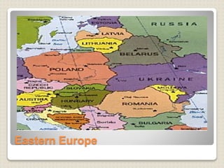
The landscapes of Eastern Europe which includes the countries, capitals, landmarks, land forms and water forms as well as their major products.

Recommended
More Related Content
Viewers also liked
Similar to Eastern Europe(Landscapes)
Similar to Eastern Europe(Landscapes) (20)
Recently uploaded
Recently uploaded (20)
Eastern Europe(Landscapes)
- 2. Country Capital Albania Tirane Bosnia and Herzegovina Sarajevo Bulgaria Sofia Croatia Zagreb Czech Republic Prague Estonia Tallinn Hungary Budapest Latvia Riga Lithuania Vilnius Macedonia Skopje Moldova Chisinau Montenegro Podgorica Poland Warsaw Romania Bucharest Serbia Belgrade Slovakia Bratislava Slovenia Ljubljana memorize
- 3. albania
- 4. landmarks Apollonia Next to the city of Fier in the middle of Albania one can find the ruins of an ancient town, named after the god Apollon. Apollonia was the biggest and most important city in the ancient world. The ruins are still impressing and show a little piece of the original glory. Libraries, temples, theatres and other buildings can be visited, as well as a triumphal arch and rotted mansions.
- 5. Products-tobacco, figs, olives, wheat, maize, potatoes, vegetables, fruits, sugar beets, grapes; meat, honey, dairy products, and traditional medicine and aromatic plants
- 6. Topography-is predominantly mountainous, with 70% of the territory at elevations of more than 300 m (1,000 ft). The rest of the country consists of a coastal lowland and the lower reaches of river valleys opening onto the coastal plain. The Albanian mountains, representing a southern continuation of the Dinaric system, rise abruptly from the plains and are especially rugged along the country's borders. The highest peak, Mt. Korabit (2,751 m/9,026 ft) lies in eastern Albania on the Macedonian border. The most important rivers—the Drin, the Buna, the Mat, the Shkumbin, the Seman, and the Vijosë—empty into the Adriatic. Albania shares Lake Scutari ( Skadarsko Jezero ) with Serbia and Montenegro, Lake Ohrid ( Ohridsko Jezero ) with Macedonia, and Lake Prespë ( Prespansko Jezero) with Macedonia and Greece
- 7. Flag of Albania drin valley albania
- 8. Berat jala Land forms Water forms
- 9. Facts Albania currency – lek Capital city-tirana Religion- muslim(70 percent of its population) Language- albanian,greek,romani,vlack and slavic dialect GDP total: $25.86 billion (2012 est.) GDP per capita: $8,000 (2012 est.)
- 10. • Ethnicity: Albanian 95%, Greek 3%, other 2% (Vlach, Roma (Gypsy), Serb, Macedonian, Bulgarian) • Government-Emerging democracy. • Land area: 10,579 sq mi (27,400 sq km); total area: 11,100 sq mi (28,748 sq km) • Population (2014 est.): 3,020,209 (growth rate: 0.3%);
- 12. landmarks The Mehmed Paša Sokolović Bridge This is a historic bridge in Višegrad, over the Drina River in eastern Republika Srpska entity of Bosnia and Herzegovina. It was completed in 1577. by the Ottoman court architect Mimar Sinan on the order of the Grand Vizier Mehmed Paša Sokolović. UNESCO included the facility in its 2007 World Heritage List. The bridge is widely known because of the book ''The Bridge on the Drina'' (1945) written by Yugoslav writer Ivo Andrić, Nobel prize winning author.
- 13. Products- wheat, corn, fruits, vegetables; livestock
- 14. Topography Bosnia and Herzegovina features hills, mountains, and valleys. Approximately 50% of the land is forested. The country has three main geographic zones: high plains and plateaus along the northern border with Croatia, low mountains in the center, and the higher Dinaric Alps which cover the rest of the country. Approximately 10% of the land in Bosnia and Herzegovina is arable. Bosnia and Herzegovina is subject to frequent and destructive earthquakes.
- 15. Land and water forms landforms Water forms
- 16. Facts Name: Bosnia and Herzegovina (long form) Republic of Bosnia and Herzegovina Capital City: Sarajevo (310,605 pop.) (436,000 metro) Bosnia and Herzegovina Population:3,875,723 (2013 est.) Ethnicity: Bosniak 48%, Serb 37.1%, Croat 14.3%, other 0.6% note: Bosniak has replaced Muslim as an ethnic term in part to avoid confusion with the religious term Muslim - an adherent of Islam
- 17. •GDP total: $32.08 billion (2012 est.) •GDP per capita: $8,300 (2012 est.) •Language: Bosnian (official), Croatian (official), Serbian •Largest Cities: (by population) Sarajevo, Banja Luka, Zenica, Tuzla, Mostar, Bihac, Bugojno, Brcko, Bijeljina, Prijedor, Trebinje, Travnik •Religion: Muslim 40%, Orthodox 31%, Roman Catholic 15%, other 14% •type of government-:parliamentary representative democracy
- 18. croatia
- 19. Landmarks FlEuphrasian Basilica The 6th century Euphrasian Basilica is the top attraction of Poreč, a 2,000 year old town in Istria. It is one of the best examples of early Byzantine architecture in the Mediterranean region and, for the most part, has retained its original shape, though accidents, fires and earthquakes have altered a few details. The present basilica was built on the site of an older basilica during the period of Bishop Euphrasius. The wall mosaics were executed by Byzantian masters and the floor mosaics by local experts.
- 20. Water forms Dalmatian coast Land forms The old town
- 21. Products- arable crops (wheat, corn, barley, sugar beet, sunflower, rapeseed, alfalfa, clover); vegetables (potatoes, cabbage, onion, tomato, pepper); fruits (apples, plum, mandarins, olives), grapes for wine; livestock (cattle, cows, pigs); dairy products
- 22. Topography Croatia is geographically diverse, with flat plains along the Hungarian border, as well as low mountains and highlands near the Adriatic coast. The country is generally divided into three main geographic zones: the Pannonian and Peri- Pannonian Plains in the east and northwest, the central hills and mountains, and the Adriatic coast. Approximately 24% of Croatia's land is arable. Croatia's natural resources include: oil, some coal, bauxite, low-grade iron ore, calcium, natural asphalt, silica, mica, clays, and salt. Croatia's natural environment experiences effects from frequent earthquakes, air pollution from metallurgical plants, coastal pollution from industrial and domestic waste, and forest damage.
- 23. Facts Name: Croatia (long form) Republic of Croatia Capital City: Zagreb (686,568 pop.) (1,288,000 metro) Croatia Population: 4,475,611(2013 est.) Religion: Roman Catholic 87.8%, Orthodox 4.4%, other Christian 0.4%, Muslim 1.3%, other and unspecified 0.9%, none 5.2%
- 24. •Currency:Croatian kuna •Ethnicity: Croat 89.6%, Serb 4.5%, other 5.9% (including Bosniak, Hungarian, Slovene, Czech, and Roma) •GDP total: $79.14 billion (2012 est.) •GDP per capita: $18,100 (2012 est.) •Language: Croatian (official) 96.1%, Serbian 1%, other and undesignated 2.9% (including Italian, Hungarian, Czech, Slovak, and German)
- 25. Romania
- 26. landmarks The Turda Salt Mine The salt mine of Turda can be found in the Dugau-Valea Sarata area of Turda, and it is over 13 million years old, weighing a total of 38 million tons. Tourists can enter the mines and admire their exquisite natural beauty through the Salina- Durgau tourist center. Highlights include the Altar Room, the Rudolf Mine, the Terezia Mine (367 feet tall) and the Ghizela Room.
- 27. Products-coal, oil, natural gas, hydro, nuclear and wind). Romania's main exports are agricultural and food products ,wines and alcoholic drinks , wood products, textiles and leather , industrial machinery, electrical and electronic equipment, metallurgic products, cars , software, pharmaceuticals, fine chemicals.
- 28. topography The backbone of Romania is formed by the Carpathian Mountains, which swing southeastward and then westward through the country. The southern limb of this arc-shaped system is known as the Transylvanian Alps, whose compact, rugged peaks rise to 2,543 m (8,343 ft) in Mt. Moldoveanu, Romania's highest. The eastern Carpathians have an average elevation of 1,000 m (3,300 ft) and exceed 1,900 m (6,200 ft) only in the highest ranges. On the eastern and southern fringes of the Carpathian arc are the low plateau sand plains of Walachia, extending to the Prut River (Moldovan border) in the east and to the Danube(Bulgarian border) in the south. On the inside of the Carpathian arc is the Transylvanian Basin, a hilly region dissected by the wide, deep valleys of the Mures and Somes rivers
- 29. Alpine pasture danube pasture Land forms Water forms
- 30. Facts Name: Romania Capital City: Bucharest (10,000,000 pop.) (2,150,000 metro) Romania Population: 21,790,479 (2013 est.) Ethnicity: Romanian 89.5%, Hungarian 6.6%, Roma 2.5%, Ukrainian 0.3%, German 0.3%, Russian 0.2%, Turkish 0.2%, other 0.4% Type of government:unitary state
- 31. •GDP total: $274.1 billion (2012 est.) •GDP per capita: $12,800 (2012 est) •Language: Romanian 91% (official), Hungarian 6.7%, Romany (Gypsy) 1.1%, other 1.2% •Religion: Eastern Orthodox (including all sub-denominations) 86.8%, Protestant (various denominations including Reformate and Pentecostal) 7.5%, Roman Catholic 4.7%, other (mostly Muslim) and unspecified 0.9%, none 0.1%
- 32. Hungary
- 33. landmarks The Caves of Lillafüred-Lillafüred in the Bükk Mountains is another very popular spa destination in Hungary. It's also famous for its many spectacular caves, all within an easy walk of the town. Some of the most interesting to explore are the István Cave with its fantastic stalactite formations
- 34. Fisherman basion lake balaton Land forms Water forms
- 35. Products-mining, metallurgy, construction materials, processed foods, textiles, chemicals (especially pharmaceuticals), and motor vehicles. Hungary's main agricultural products are wheat, corn, sunflower seed, potatoes, sugar beets; pigs, cattle, poultry, and dairy products.
- 36. Topography The country has mostly plains; mountains can be found only in the middle of Transdanubia and in the northern part of East Hungary
- 37. Facts Name: Hungary Republic of Hungary (long form) Capital City: Budapest (1,721,556 pop.) (3,271,110 metro) Hungary Population: 9,939,470 (2013 est.) Currency: Hungarian forint Type of government: parliamentary government
- 38. •Ethnicity: Hungarian 92.3%, Roma 1.9%, other or unknown 5.8% •GDP total: $195.4 billion (2012 est.) •GDP per capita: $19,800 (2012 est.) •Language: Hungarian 93.6%, unspecified 6.4% • Religion: Roman Catholic 51.9%, Calvinist 15.9%, Lutheran 3%, Greek Catholic 2.6%, other Christian 1%, other or unspecified 11.1%, unaffiliated 14.5%
- 39. Slovenia
- 40. landmark
- 41. Topography Slovenia features a small coastal strip on the Adriatic, an alpine region adjacent to Italy, and mixed mountains and valleys with numerous rivers in the east. Slovenia's natural resources include lignite coal, lead, zinc, mercury, uranium, and silver. Approximately 11% of Slovenia's land is arable
- 42. Facts Name: Slovenia (long form) Republic of Slovenia Capital City: Ljubljana (272,220 pop.) Slovenia Population: 1,992,690 (2013 est.) Ethnicity: Slovene 83.1%, Serb 2%, Croat 1.8%, Bosniak 1.1%, other or unspecified 12% GDP total: $58.06 billion (2012 est.) GDP per capita: $28,600 (2012 est.) Type of government :parliamentary republic
- 43. •Language: Slovenian (official) 91.1%, Serbo- Croatian 4.5%, other or unspecified 4.4%, Italian (official, only in municipalities where Hungarian national communities reside), Hungarian (official, only in municipalities where Hungarian national communities reside) • Religion: Catholic 57.8%, Muslim 2.4%, Orthodox 2.3%, other Christian 0.9%, unaffiliated 3.5%, other or unspecified 23%, none 10.1%
- 44. Karst bled lake Land forms Water forms
- 45. Macedonia
- 46. landmark
- 47. Topography Macedonia is a landlocked country that is geographically clearly defined by a central valley formed by the Vardar river and framed along its borders by mountain ranges. The terrain is mostly rugged, located between the Šar Mountains and Osogovo, which frame the valley of the Vardar river. Three large lakes — Lake Ohrid, Lake Prespa and Dojran Lake — lie on the southern borders, bisected by the frontiers with Albania and Greece. Ohrid is considered to be one of the oldest lakes and biotopes in the world.
- 48. Products-major agricultural production is of tobacco, rice, grapes, fruits and vegetables. There is significant production of wine from domestic grapes. Cattle, sheep, horses, goats and pigs are raised, along with chickens and bees for honey. The raising of sheep and chickens is much more common than that of cattle, horses and goats. There is a rapidly growing textile industry, primarily for export, and the manufacturing sector has been growing rapidly in recent decades.
- 49. facts •Name: Macedonia (long form) Republic of Macedonia •Capital City: Skopje (668,518 pop.) •Macedonia Population: 2,087,171 (2013 est.) •Ethnicity: Macedonian 64.2%, Albanian 25.2%, Turkish 3.9%, Roma (Gypsy) 2.7%, Serb 1.8%, other 2.2% •GDP total: $10.5 billion (2012 est.) •GDP per capita: $10,700 (2012 est.) •Currrency :macedonian denar
- 50. •Language: Macedonian (official) 66.5%, Albanian (official) 25.1%, Turkish 3.5%, Roma 1.9%, Serbian 1.2%, other 1.8% •Religion: Macedonian Orthodox 64.7%, Muslim 33.3%, other Christian 0.37%, other 1.63% •Government type-parliamentary represent government
- 51. Korab mountain makta Land forms Water forms