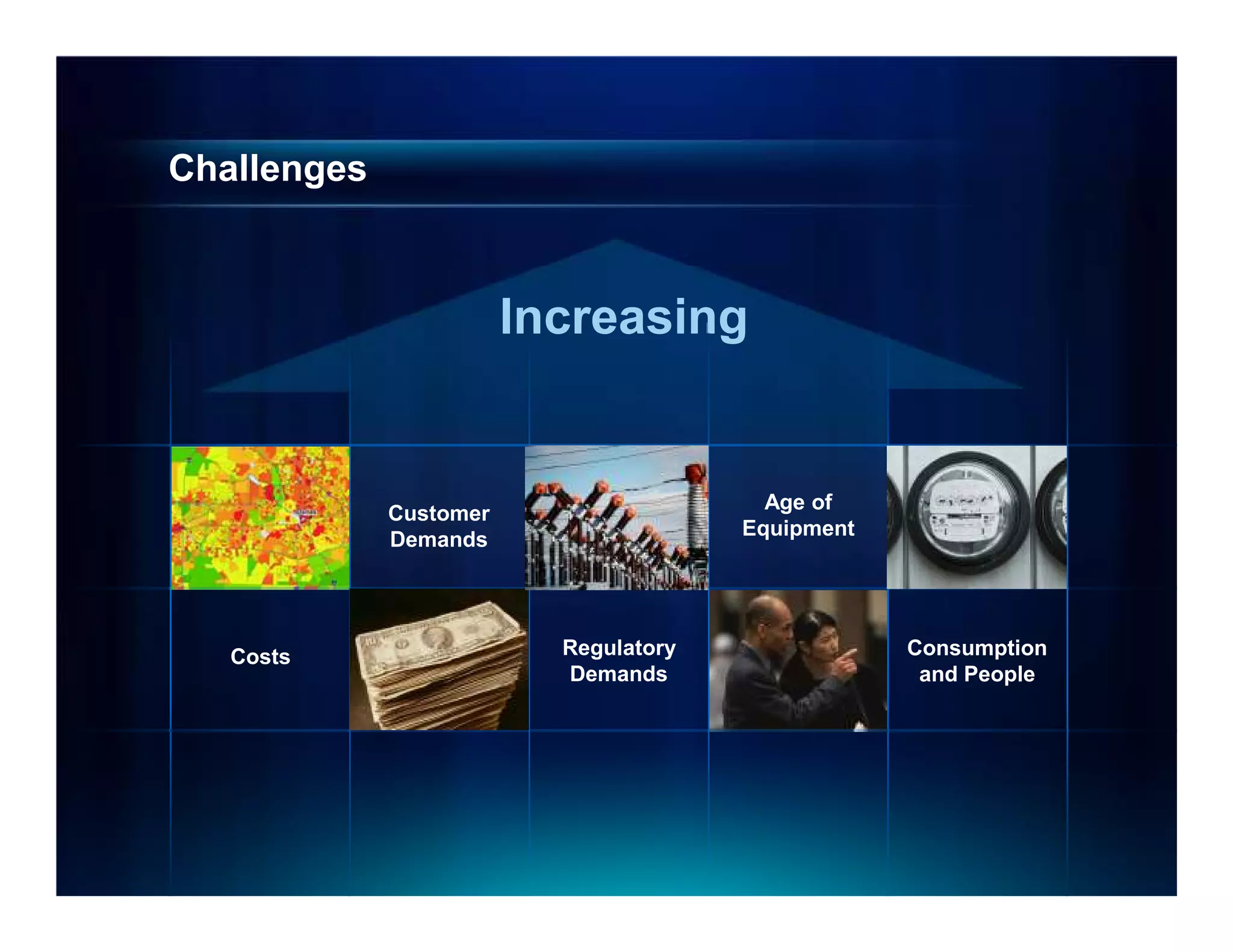
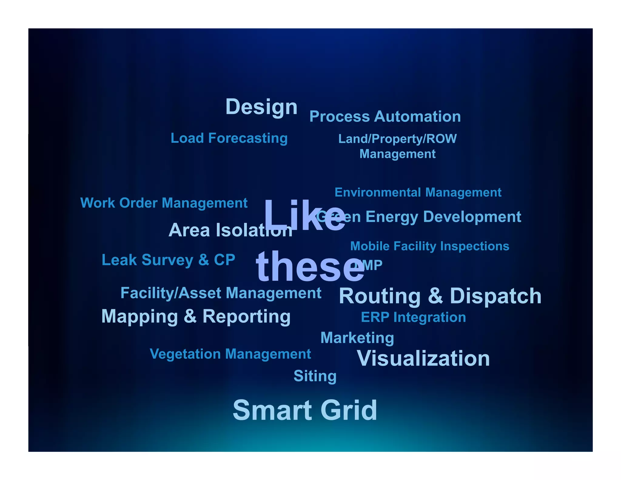
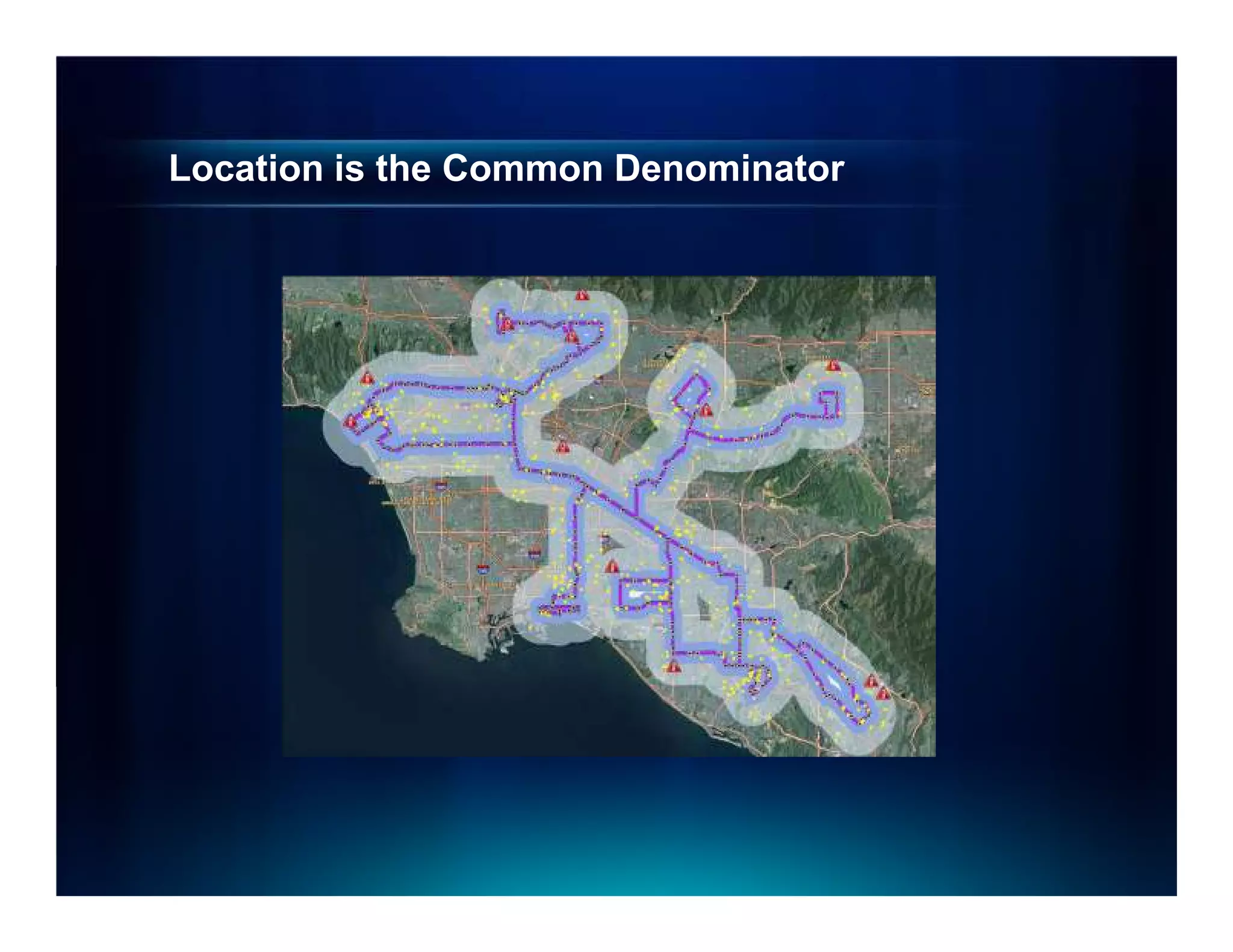
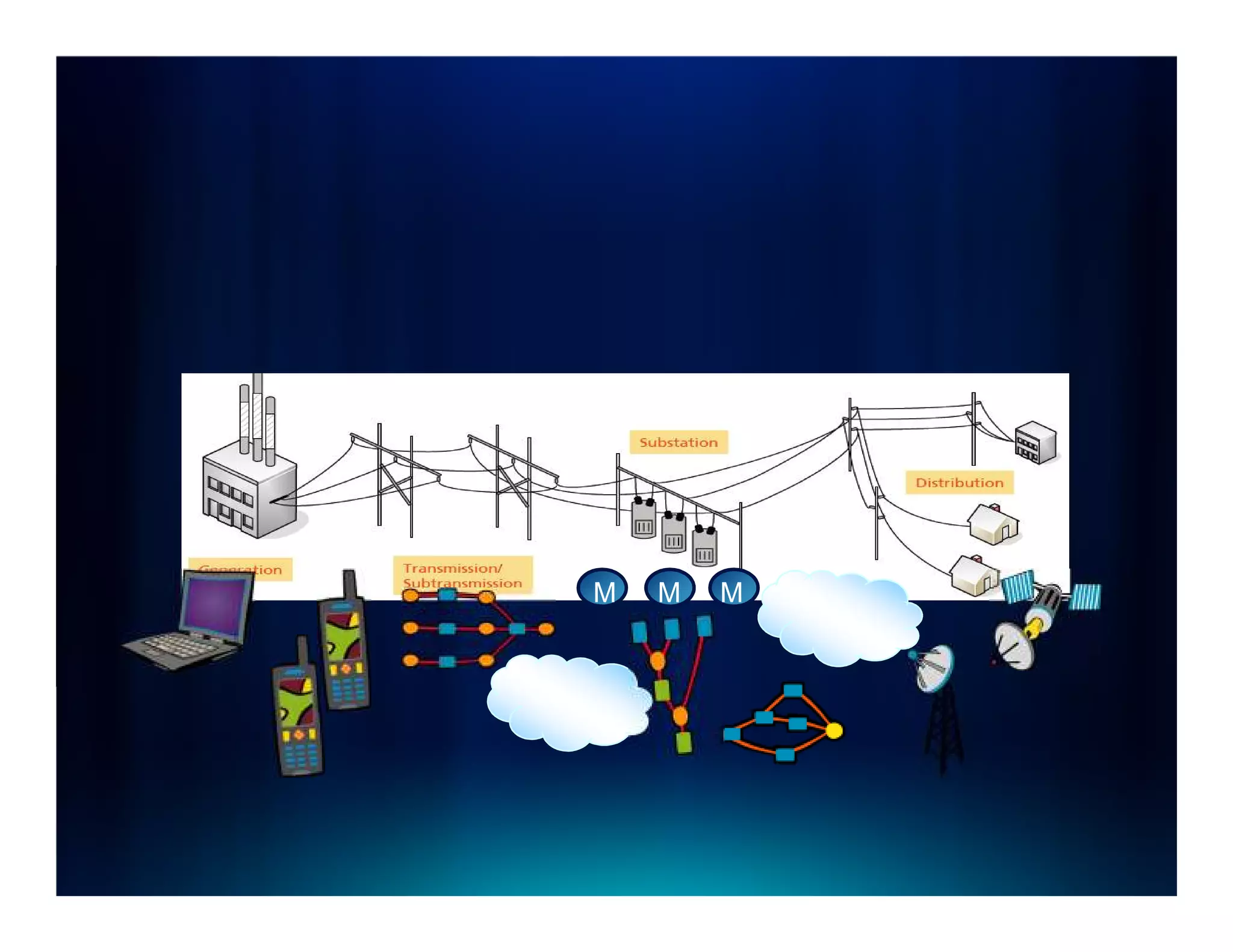
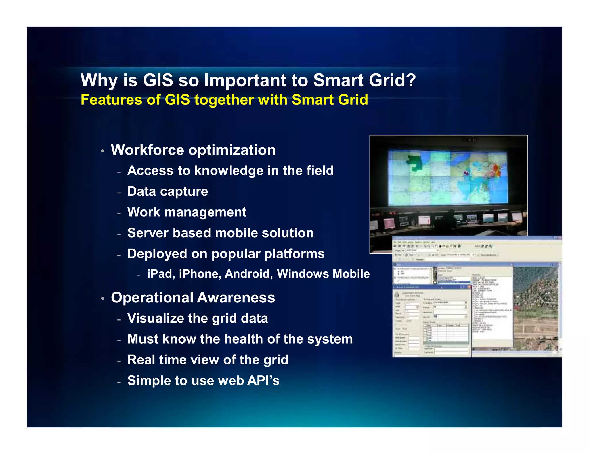
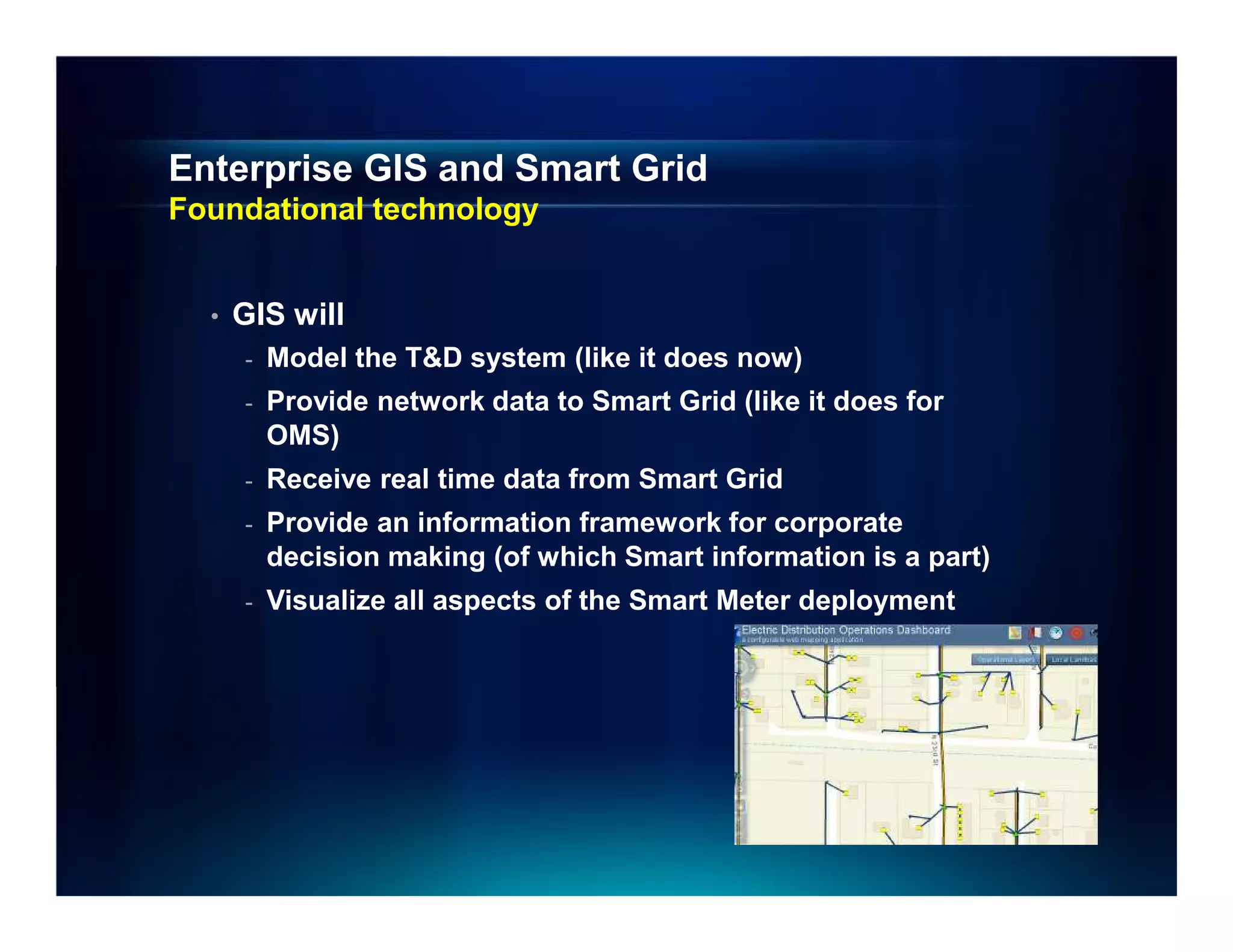
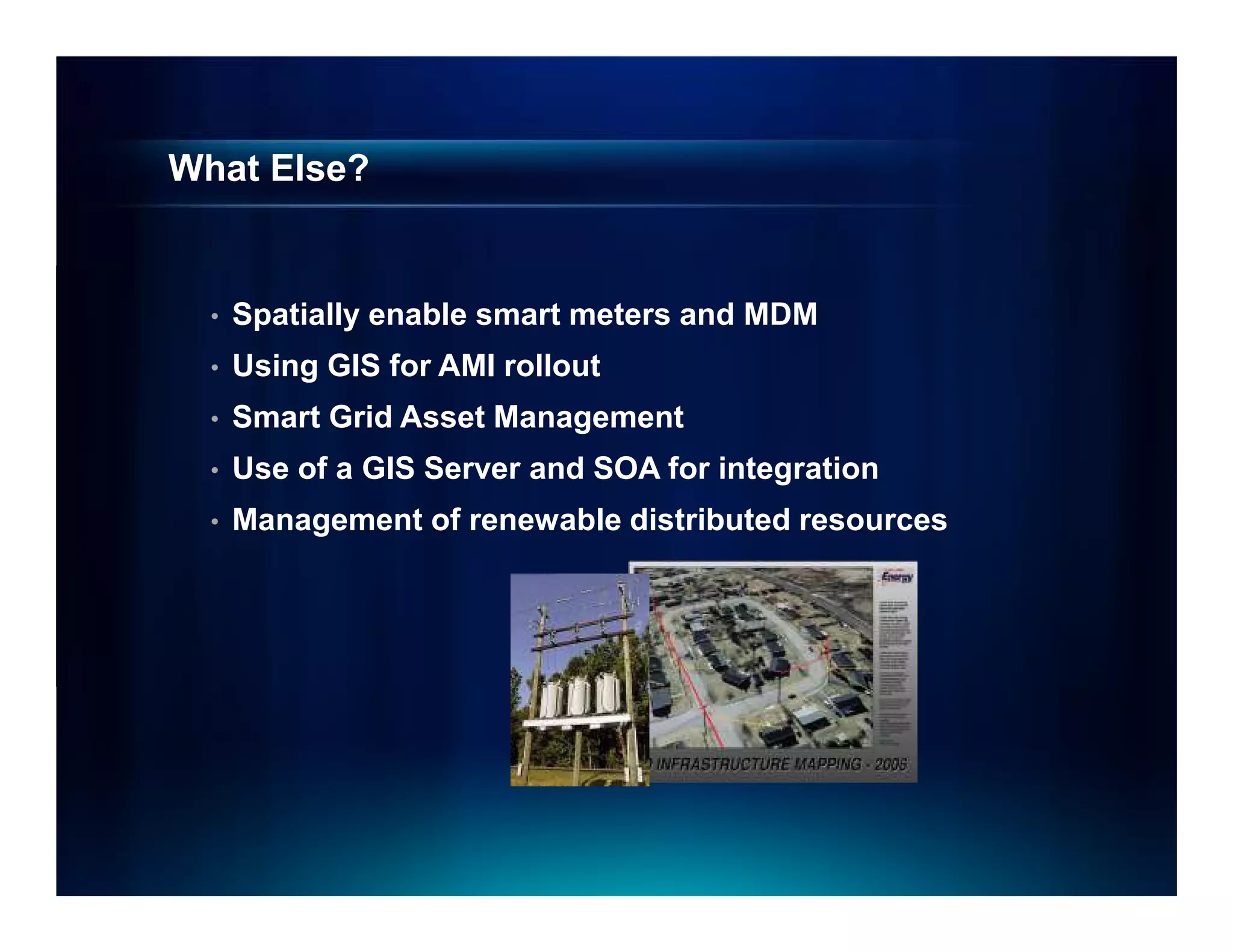
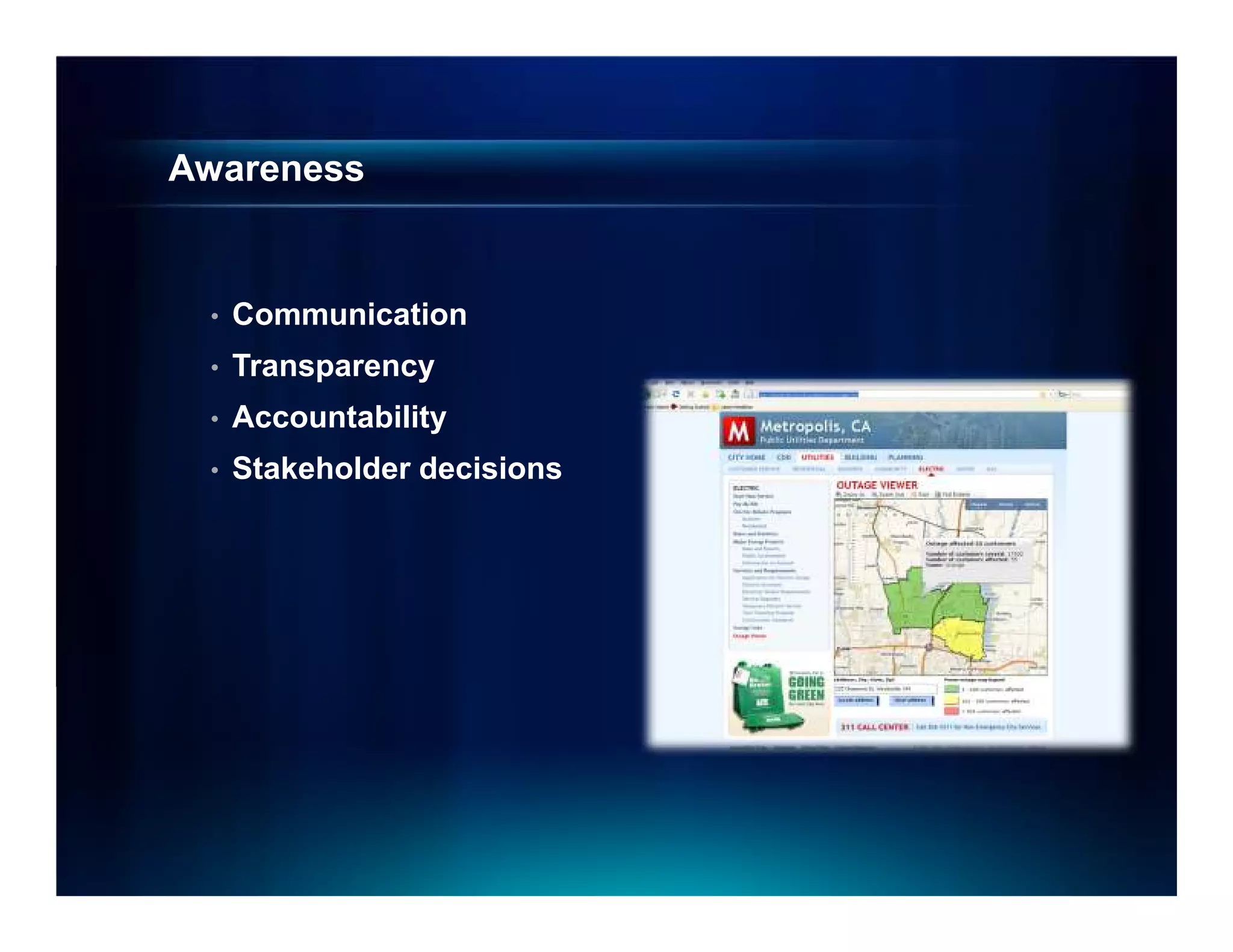
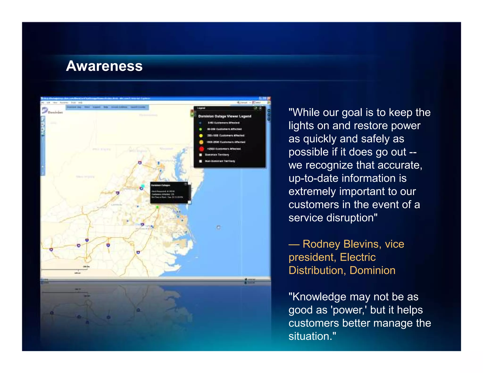
William Meehan, Director Utility Solutions at ESRI, Procálculo – Prosis
Congreso Andesco de Servicios Públicos y TIC 14º Nacional y 5º Internacional, Cartagena Colombia, Junio 27, 28 y 29 de 2012
Mitel offers a portfolio of voice, data, and managed network solutions including local and long distance phone services, audio and web conferencing, dedicated internet access, MPLS VPN services, mobile wireless services, and network management tools. Their solutions are designed to meet the total communications needs of businesses through a single provider and are supported by industry-leading customer service.
Les "systèmes intelligents" constituent la nouvelle génération de systèmes embarqués, qui, en s'appuyant sur les caractéristiques de robustesse et de déterminisme de leurs aînés, se connectent au cloud afin d'enrichir l'expérience utilisateur, qu'il s'agisse d'entreprises (collectant des données ou surveillant des systèmes par exemple), de particuliers (à la maison ou dans un contexte médical, ou bien dans la voiture) ou bien d'autres machines (dans le cas de systèmes automatisés à grande échelle). Le cloud et particulièrement Windows Azure fourni les vecteurs de communication et les moyens de stocker massivement des données et de les traiter, déchargeant ainsi les installations locales et donc rendant le déploiement de ses systèmes plus simple. Cette session, riche en exemples concrets, présentera la stratégie qui est celle de Microsoft autour du futur des systèmes embarqués, et leur connexion au cloud, ainsi que les technologies et les partenariats mis en oeuvre pour accélérer ces déploiements de systèmes intelligents. avec un exemple qui parlera à tous: le futur de la voiture, avec Windows Embedded Automotive!
Corporate Senior Vice President, Noriyuki Toyoki, shares Fujitsu’s vision of the increasingly prevalent role technology takes in our daily lives. Everything you ever wanted to know about big data, smart grids, supercomputing and how they can support society through disaster recovery, healthcare ICT and food production - to create a human centric intelligent society.
The document describes a wireless GPS wristwatch tracking solution called TIDGET. TIDGET is a low power GPS tracking device developed by NAVSYS for the US Army. It uses a client/server approach to send raw GPS data through a ZigBee wireless link to a LocatorNet server for processing. The server uses software defined radio to compute positions from the GPS data. TIDGET can operate for over 30 days on a wristwatch battery by offloading GPS processing to the server. A web portal allows users to access location data from the tracking devices.
Avaya%20data%20solutions%20 %20creating%20a%20fit%20for%20purpose%20networkSteven J. Bocker, MBA
The document discusses the need for a new type of "fit for purpose" enterprise network architecture to address the challenges of today's environment where real-time communications and collaboration applications are driving increased network traffic and mobility requirements. Traditional general purpose network architectures were not designed for these demands and can experience problems as more hardware and bandwidth are added, such as increased management complexity and scalability issues. A new approach focused specifically on supporting real-time applications is needed to provide efficient, effective access for the modern workforce.
MercaSID is a manufacturer and distributor in the Dominican Republic that was experiencing issues with its aging network. It deployed a new network solution from Juniper Networks including EX Series switches in the data center and locations, as well as WLA wireless access points and a WLC controller. This provided a highly reliable, unified wired and wireless network that improved network performance, simplified management, and supported the growing business needs of employees and partners.
This document provides an overview of a company's private digital network capabilities and services. The company is a full-service systems integrator that offers converged solutions for video, IP networking, applications and integration. It has a nationwide presence and over 55 employees. The private digital network includes fiber rings, tier 3+ data centers, carrier neutral hotels, high performance, reliability, support services and secure data center environments. It provides private cloud services for voice, data, video, storage and more.
[Case study] City of Peoria Municipality: Getting the most impact for GIS tec...Schneider Electric
Project Type:
Operational utility solutions
Applications:
Provide a graphical, data-rich environment that displays the information utilities need for
maximum reliability and efficiency.
Customer benefits:
• Less time and resources to maintain
• Increased accuracy of information
• Highly configurable and easily adapted for multiple uses
This document introduces representations, which allow storing symbolization rules with geographic data. Representations provide greater control over symbolization and allow dynamic depiction of features. The tutorial contains 5 exercises to learn about creating and modifying representations, overriding rules for individual features, using free representations, and automating mapmaking with geoprocessing tools. It demonstrates converting existing layer symbology to representations and creating representations from scratch.
Harris County Appraisal District is considering migrating its parcel data from an ESRI SDE database to parcel fabric. A pilot project will test the migration in two areas containing a mix of parcel types and geometries. Lessons from other Texas appraisal districts that migrated indicate more upfront data cleanup is needed. Once complete, the migration is expected to improve topology, increase consistency and productivity through automated workflows, and better track parcel history over time. At over 1.4 million parcels, this will be the largest parcel fabric migration to date.
Esri Location Analytics for Business IntelligenceEsri
This document discusses Esri's Location Analytics solution which integrates business intelligence (BI) and geographic information system (GIS) technologies. The Location Analytics solution seamlessly embeds mapping and spatial analysis tools into existing BI systems. This allows users to visualize and analyze key BI data on interactive maps to discover new patterns and trends. The benefits of Location Analytics include more valuable analytics through spatial visualization, leveraging existing BI investments, and minimal disruption to existing workflows and skills.
This document discusses the evolution of location business models from carrier gardens to trusted third party applications to service delivery platforms. It describes characteristics of each model and provides examples. It emphasizes that large enterprises require telecom-enabling services to integrate their internal applications rather than separate point solutions. The document advocates for exposing geospatial functionality through service-oriented architectures to integrate across departments. It provides examples of industry vertical fits and discusses how one company automated their field service process using location technologies to increase productivity.
KliqMap for Esri: Actionable Location AnalyticsKT-Labs
At KT Labs we strongly believe that there is much more to “Location Intelligence” that simply linking a map to a report.
KliqMap leverages QlikView, Esri ArcGIS (the leading GIS platform) and KT Labs’ Planning Suite to create a fully integrated and interactive environment where analytics and simulation can be performed in the context of business processes. The native access to “ArcGIS Online” makes this solution accessible to businesses of any size with an amazing simplicity and speed of deployment.
With KliqMap the GIS becomes a key element in empowering decision making through analysis, simulation, prediction and optimization.
This is what we call “Actionable Location Analytics”.
This document provides instructions for creating an animation in ArcMap to visualize population changes in the contiguous United States from 1800 to 2000 using county-level feature class layers. It describes organizing data in ArcCatalog, viewing an existing animation, and creating a new animation to examine population changes in the ArcMap display and through a graph over time. The steps can be applied to other data types and programs besides ArcMap.
This document provides instructions for creating an address locator in ArcGIS that uses alternate street names and place name aliases. It describes how to create a new address locator using the US Streets with AltName style and selecting the streets feature class and altname table as reference data. It then explains how to use the new address locator in ArcMap to locate addresses, demonstrating how alternate names and aliases are searched to find potential matches.
During the Great Depression of the 1930s, movies and cartoons provided much needed entertainment for Americans. Animated films used individual drawings photographed in sequence to depict movement. Major studios like MGM, Warner Brothers, and Walt Disney animated cartoons and films that brought characters like Mickey Mouse and Bugs Bunny to life. The introduction of sound and color further advanced animated films and cartoons during this era.
This document provides an overview of common GIS data models, including PODS and APDM. PODS is a pipeline open data standard that uses a relational, hierarchical structure and GUIDs. APDM is designed for Esri software and uses relational and spatial relationships as well as Esri database types to differentiate domains. Both standards provide structured models for storing pipeline GIS data.
Network Mapping - Esri UK Annual Conference 2016Esri UK
This document discusses how NM Group uses geospatial technology and mapping to provide solutions for infrastructure projects. It outlines their process of taking infrastructure data from proprietary formats and converting it into mapbooks, GIS layers, reports and web services using ArcGIS tools. This streamlines their workflow compared to other software, allowing them to produce maps, reports and deliverables for infrastructure corridors more quickly and with less manual effort and errors. The mapping solutions provide spatial context and relationships that spreadsheets alone cannot, and make the data more accessible and usable for clients.
ArcGIS Pro is Esri's new desktop GIS software that integrates 2D and 3D mapping, analysis, and editing capabilities. It combines the functionality of ArcMap, ArcCatalog, ArcGlobe, and ArcScene into a single application with a modern 64-bit architecture. ArcGIS Pro allows users to work with multiple maps and layouts simultaneously. It also features tasks that guide users through workflows. The software is tightly integrated with ArcGIS Online and portal environments. Esri is continuously improving ArcGIS Pro based on customer feedback, with new releases adding capabilities like vector tiles, publishing by reference, 3D scenes, and concurrent licensing.
The document discusses how ArcGIS software has evolved to support 3D capabilities that allow users to process drone imagery into 3D models and point clouds, manage large volumes of imagery and 3D data from multiple sources, and share 3D content and services. Challenges of 3D imagery such as file sizes, projections, and accuracy are addressed with tools in ArcGIS like Drone2Map and new 3D scene layer formats that facilitate the creation and use of 3D content across industries.
Telling Stories with Maps - Esri UK Annual Conference 2016acEsri UK
Story Maps are web apps created with ArcGIS Online that combine maps, text, photos, and multimedia to tell geography-based stories. There are different types of Story Map apps that allow for sequential narratives, journal-style narratives, displaying single maps, or comparing two maps. Story Maps are used to tell stories, raise awareness, create reports, highlight locations, share analysis, and compare maps. They are hosted through ArcGIS Online or Portal for ArcGIS and can be easily created and shared.
Spatial data defines a location using points, lines, polygons or pixels and includes location, shape, size and orientation. Non-spatial data relates to a specific location and includes statistical, text, image or multimedia data linked to spatial data defining the location. The document outlines key differences between spatial and non-spatial data, noting that spatial data is multi-dimensional and correlated while non-spatial data is one-dimensional and independent, with implications for conceptual, processing and storage issues.
An introduction to GIS Data Types. Strengths and weaknesses of raster and vector data are discussed. Also covered is the importance of topology. Concludes with a discussion of the vector-based format of OpenStreetMap data.
This document provides an overview of geographical information systems (GIS), including definitions of GIS, its basic principles and components, data types used in GIS (vector and raster), advantages and applications of GIS. Specifically, it defines GIS as a computer system for capturing, storing, analyzing and displaying spatially referenced data. It describes the key principles of data capture, management, analysis and visualization. It outlines the typical hardware, software and data components of a GIS, and differentiates between vector and raster data types. Finally, it discusses advantages like accurate representation and analysis, and applications across different domains.
TELUS Case Study: GIS for Telecommunicationseventspat
This document describes how TELUS implemented an iVAULT system to improve access to and use of their spatial data. Key points:
1. TELUS integrated their disparate GIS systems and data into a single iVAULT system with a spatial data store, allowing unified access for field users and departments.
2. The iVAULT system included a new FieldView application for viewing, searching, analyzing and editing spatial and attribute data via web and mobile.
3. The spatial data store cleaned up TELUS' IMAGE database and consolidated over 1,000 design files, improving data quality and access.
4. The unified system allows TELUS to better analyze customer and network data
This document summarizes a presentation on the strategic positioning of telecommunications operators in information and communications technology (ICT) value networks. It discusses the convergence of telecom, software, hardware and media industries and increasing complexity of ICT ecosystems. It analyzes the quantitative relationships between telecom activities and other industry segments using cluster analysis. The results show telecom activities are most strongly associated with software and media activities, and less associated with hardware components. Governance of relationships ranges from market-based to strategic cooperation, depending on the level of interdependency between industries.
TELUS Case Study: iVAULT implementation improved corporate intelligence eventspat
This document summarizes a webinar about TELUS's implementation of the iVAULT content management system. Some key points:
- iVAULT was implemented to improve TELUS's corporate intelligence by creating a centralized spatial data store and new FieldView application. This consolidated data from disparate legacy systems and maps like ArcGIS, MapGuide, and Google Maps.
- The new architecture included an Oracle spatial data store replicating TELUS infrastructure data from their Intergraph Framme system. This cleaned up issues and standardized the data.
- A new FieldView application was developed to provide customized analysis tools for various departments through a web interface on both desktop and mobile.
- The
Suraj Informatics is an IT and telecommunications infrastructure services company with offices across India that offers wireless infrastructure, campus networking solutions, security surveillance, RFID solutions, and software products and platforms while focusing on industries like government, broadband services, transportation, education and more. The company has over 50 employees including a management and technical team and partners with technology providers like Cisco, Psion and Altai to deliver end-to-end solutions to customers.
With millions of hotspots deployed around the world, and ever growing integration of Wi-Fi into wireless devices, Wi-Fi is rapidly becoming ubiquitous. This presentation discusses Wi-Fi evolution, its critical role in addressing the looming 1000x data challenge, enabling smart connected homes, and exciting new frontiers it is poised to explore.
For more information please visit www.qualcomm.com/wi-fi
Download the presentation here: http://www.qualcomm.com/media/documents/wireless-networks-wi-fi-evolution
Effective Data Collection and Management through Mobile Phone ApplicationsMichael Baker Jr., Inc.
This document discusses how mobile phone applications can effectively collect and manage data. It provides examples of using mobile apps for tasks like public needs assessments, design work, and capturing or analyzing large amounts of data by leveraging mobile technologies. Specific considerations for deploying smartphone apps include platform choice, connectivity needs, ruggedness, battery life, and GPS accuracy. The document outlines benefits like improved user efficiency, low costs, and ability to integrate maps, cameras, and GPS. Examples illustrated include infrastructure condition assessments, regulatory delineations, and stormwater permit tracking using mobile GIS apps.
Back to the future with simple wholesale services nowADVA
The past few months have shown that networks are essential for all of us, and it’s clear that we need to rethink how we build and use them. The digitization of all ecosystems will be a key part of the “new normal,” and efforts to digitize networks need to accelerate. It’s also now important for service providers to team up to address changing requirements. Is charging for network usage becoming essential? What new technologies are emerging that will enable us to do more with less and at a faster pace? In his NAMEX 2020 workshop, Christoph Glingener explained how simple wholesale services will be key to the digital revolution.
Transforming Cook County: Changing the Game with Shared Services and Open Gov...Greg Wass
Cook County is facing a fiscal crisis with expenses exceeding revenues each year. This is driving the need to transform through shared services and open government. The document discusses lessons learned from examples like Zipcar about identifying shared service opportunities both within and outside the organization, leveraging behavioral changes, and letting customers participate through open data and civic apps. This would help modernize Cook County's legacy IT systems and processes to be more efficient, collaborative, and customer-focused.
P2P - Real Time Communications in the EnterpriseMead Eblan
"Mainstreaming Peer-to-Peer Connectivity:
Real-Time Communications in the Enterprise"
- Presented at Digital Government Institute Conference on IPv6
- September 2007
Firetide is a market leader in providing wireless mesh networking equipment for public safety applications like real-time video surveillance. Their unique core technology includes multiple patents and their equipment has been proven through 3000 worldwide installations. Firetide's mesh technology provides high performance and reliability comparable to fiber networks, with benefits like ease of deployment and mobility. They are expanding into new markets like transportation, smart grid, and utilities and recently raised $8.6 million in funding.
The document discusses various topics related to wireless and mobile computing including wireless communication, effects of device portability, mobile computing platforms, wireless and fixed networks, wireless management, building blocks of mobile computing, CDMA and DAMA, wireless networks, CSMA problems, and the hidden terminal problem. It also covers applications of wireless technology and security concerns in wireless networks.
CDMA2000 and WCDMA are the two main 3G standards. CDMA2000 uses a 1.25 MHz bandwidth and has achieved success in markets like Korea and Japan, with over 80 million subscribers. It provides broader coverage than WCDMA which uses 5 MHz bandwidth and operates at higher frequencies. While WCDMA's initial data rate was 384 Kbps, CDMA2000's 1xEV-DO can support up to 2.4 Mbps, giving it a performance advantage currently. Both standards continue to evolve but CDMA2000 has proven successful in commercial deployments in Asia.
This document discusses the benefits of moving enterprise utility GIS systems to the cloud. It begins by outlining challenges utilities currently face, such as increased data volume and complexity from smart grid technologies. This has led to greater data management challenges around quality, timeliness, and integration. The document then argues that the cloud can help address these issues by providing benefits like reduced costs, increased storage, flexibility, and mobility. It also allows IT teams to focus less on infrastructure maintenance. Finally, the document presents a two-step solution approach using ArcFM software hosted in the cloud to provide utilities with a complete GIS system.
Future networks including cloud computing, mobile and next-generation networks
This document discusses future networks and related technologies being studied by ITU-T Study Group 13, including 5G, software-defined networking, cloud computing, big data, mobility management, and more. It provides an overview of the study group's mandate, leadership structure, and work items covering requirements, architectures, and mechanisms for future networks.
Regulator's role in ensuring successful MNP implementation and managementBSP Media Group
The document discusses the regulator's role in ensuring successful mobile number portability (MNP) implementation and management in Tanzania. It provides an overview of Tanzania's communications sector, including policies, regulations, licensing frameworks, market growth, and infrastructure development. It then examines available MNP approaches, noting Tanzania opted for direct routing using All Call Query and a centralized clearinghouse operated by an independent third party. The regulator's involvement in MNP includes establishing robust processes, managing numbering resources, ensuring quality of service, and facilitating dispute resolution. Stakeholder collaboration is also key to the success of MNP.
Digital Prospectors Corp (DPC) is a small, woman-owned IT and engineering consulting firm specializing in providing qualified professionals to government agencies and commercial clients. DPC has a facility security clearance and is certified as a small, woman-owned business. It has extensive experience working with Department of Defense agencies and contractors, providing over 600 personnel to projects. DPC's core competencies include engineering, IT, and administrative services.
Augview presentation GE user conference bali 2014 - MIke BundockGeo AR Games
This presentation is available as a You Tube video with Mike Bundock, CEO and founder of Augview. http://youtu.be/uQX_XMnjfng?list=PLhXjq-hI-gjCsDc1pfqLIOYODK4he2U92
The document discusses a new managed services offering called SmartCloud from SpiderCloud Wireless that provides indoor 3G and WiFi access as a managed service for enterprises. It allows enterprises to outsource indoor wireless access and mobility management to reduce costs and IT burdens. SmartCloud provides a seamless network experience between enterprise LANs and cellular networks for mobile employees. The system architecture uses scalable radio nodes and services nodes to provide a flexible, mobile network as a service. This allows enterprises to focus on their core business instead of managing complex indoor wireless networks.
Fibertech Networks is a fiber optic network provider founded in 2000 and headquartered in Rochester, NY. It owns over 8,200 miles of fiber network across 23 metropolitan areas in the Northeast and Mid-Atlantic. Fibertech provides metro Ethernet, SONET, DWDM, dark fiber, internet access, and colocation services to over 800 business customers. It prides itself on award-winning customer service and a privately-owned, flexible network that allows for scalable, reliable connectivity.
Similar to Sistemas de Información Geográfica en la gestión y operación de redes de servicios públicos (20)
El alcalde de Cartagena da la bienvenida a los asistentes al Decimocuarto Congreso Andesco sobre servicios públicos y TIC. Agradece que se haya elegido a Cartagena como sede y resalta la importancia de los temas a tratar, como sostenibilidad, responsabilidad social empresarial y el papel de los servicios públicos y las TIC. Pide a los asistentes que contribuyan a encontrar caminos de desarrollo para los colombianos.
La Unión Europea ha propuesto un nuevo paquete de sanciones contra Rusia que incluye un embargo al petróleo. El embargo prohibiría la importación de petróleo ruso a la UE y también prohibiría a los buques europeos transportar petróleo ruso a otros lugares. Sin embargo, Hungría se opone al embargo al petróleo, lo que podría retrasar la aprobación del paquete de sanciones de la UE.
Luis Francisco Bohórquez, Alcalde de Bucaramanga Andesco
Luis Francisco Bohórquez, Alcalde de Bucaramanga
Congreso Andesco de Servicios Públicos y TIC 14º Nacional y 5º Internacional, Cartagena Colombia, Junio 27, 28 y 29 de 2012
Jorge Eduardo Rojas Giraldo, Alcalde de Manizales Andesco
Este documento presenta información sobre cuatro ciudades colombianas piloto (Barranquilla, Bucaramanga, Pereira y Manizales) que buscan convertirse en ciudades sostenibles y competitivas. Proporciona datos demográficos e indicadores económicos, sociales y ambientales sobre estas ciudades. El objetivo es identificar acciones estratégicas en áreas como la sostenibilidad ambiental, urbana, fiscal y social para mejorar la calidad de vida de los ciudadanos.
Rodrigo Guerrero, Alcalde de Cali
Congreso Andesco de Servicios Públicos y TIC 14º Nacional y 5º Internacional, Cartagena Colombia, Junio 27, 28 y 29 de 2012
Huella de Carbono Congreso ANDESCO 2012
Congreso Andesco de Servicios Públicos y TIC 14º Nacional y 5º Internacional, Cartagena Colombia, Junio 27, 28 y 29 de 2012
Entrega del Premio Andesco a la Responsabilidad Social Empresarial Andesco
El documento presenta los resultados de una verificación independiente del Premio Andesco a la Responsabilidad Social Empresarial 2012. Se resumieron los principales cambios en las fichas técnicas, incluyendo la reducción de preguntas y solicitud de documentos, y el enfoque en 15 temas materiales clave. La participación disminuyó un 25%, pero la calificación promedio aumentó un 8%. Finalmente, se destacaron aspectos positivos y áreas de mejora.
Experiencia Internacional en Políticas Públicas para cerrar la brecha digitalAndesco
Howard Williams, Profesor emérito Universidad de Strathclyde, consultor internacional
Congreso Andesco de Servicios Públicos y TIC 14º Nacional y 5º Internacional, Cartagena Colombia, Junio 27, 28 y 29 de 2012
Experiencia Internacional en Políticas Públicas para cerrar la brecha digitalAndesco
Jorge Hernando Pedraza, Senador de la República de Colombia
Congreso Andesco de Servicios Públicos y TIC 14º Nacional y 5º Internacional, Cartagena Colombia, Junio 27, 28 y 29 de 2012
Medidas actuales para la defensa de infraestructura como elemento esencial pa...Andesco
El documento analiza el problema del hurto de infraestructura de comunicaciones en Colombia y propone una política estatal para enfrentarlo. Describe el impacto financiero y en la infraestructura que genera el robo, y propone crear un sistema de información sobre el mercado de chatarra de cobre, coordinar instituciones contra el hurto, y una estrategia de comunicación nacional.
Medidas actuales para la defensa de infraestructura como elemento esencial pa...Andesco
Tatiana Parra, Asesora para la Alta Consejería para la Convivencia y la Seguridad Ciudadana
Congreso Andesco de Servicios Públicos y TIC 14º Nacional y 5º Internacional, Cartagena Colombia, Junio 27, 28 y 29 de 2012
Medidas actuales para la defensa de infraestructura como elemento esencial pa...Andesco
Este documento presenta estadísticas sobre el hurto de infraestructura como cables de cobre y celulares en Colombia entre 2009 y 2011, y propone medidas para combatir este problema. Muestra que los eventos de hurto aumentaron 46% durante este periodo, con un costo total de reposición de $70 mil millones de pesos en 2011. Además, presenta iniciativas a nivel nacional e internacional como restringir exportaciones de cobre, crear un sistema de trazabilidad, y campañas de sensibilización pública.
Condiciones regulatorias para el despliegue de banda ancha en redes de nueva ...Andesco
Marc Eichmann (Presidente UNE)
Congreso Andesco de Servicios Públicos y TIC 14º Nacional y 5º Internacional, Cartagena Colombia, Junio 27, 28 y 29 de 2012
Condiciones regulatorias para el despliegue de banda ancha en redes de nueva ...Andesco
Este documento discute las condiciones regulatorias para el despliegue de banda ancha en redes de nueva generación. Explica que el uso de datos móviles está creciendo rápidamente y que se necesita espectro y un marco regulatorio claro. También analiza las tecnologías móviles emergentes como LTE, la gestión del espectro a largo plazo, y los desafíos regulatorios de la convergencia tecnológica.
Condiciones regulatorias para el despliegue de banda ancha en redes de nueva ...Andesco
Carlos Rebellón, Director Ejecutivo CRC
Congreso Andesco de Servicios Públicos y TIC 14º Nacional y 5º Internacional, Cartagena Colombia, Junio 27, 28 y 29 de 2012
Experiencia Internacional en Políticas Públicas para cerrar la brecha digitalAndesco
Alejandro Barros. Consultor Internacional
Congreso Andesco de Servicios Públicos y TIC 14º Nacional y 5º Internacional, Cartagena Colombia, Junio 27, 28 y 29 de 2012
Regulación de confiabilidad para el servicio de gas natural – Resolución CREG...Andesco
Este documento propone criterios y reglas para evaluar y remunerar proyectos de inversión en confiabilidad del servicio público de gas natural. Se analizan los beneficios de proyectos como plantas de gas natural importado y se concluye que reducen los costos de restricción del sistema. Se propone una metodología de evaluación de costo-beneficio y un proceso competitivo para seleccionar proyectos que minimicen los costos totales del sistema y definir su remuneración regulatoria.
Confiabilidad y garantía de abastecimiento de gas natural en el largo plazo.Andesco
Jean Phillippe Pening, Director Infraestructura, DNP
Congreso Andesco de Servicios Públicos y TIC 14º Nacional y 5º Internacional, Cartagena Colombia, Junio 27, 28 y 29 de 2012
Plan Indicativo de Abastecimiento de gas natural en ColombiaAndesco
Beatriz Herrera, Asesora Hidrocarburos UPME
Congreso Andesco de Servicios Públicos y TIC 14º Nacional y 5º Internacional, Cartagena Colombia, Junio 27, 28 y 29 de 2012
Desarrollo de la Política de garantía de abastecimiento de gas naturalAndesco
Tomás González, Viceministro de Energía MME
Congreso Andesco de Servicios Públicos y TIC 14º Nacional y 5º Internacional, Cartagena Colombia, Junio 27, 28 y 29 de 2012
What is an RPA CoE? Session 1 – CoE VisionDianaGray10
In the first session, we will review the organization's vision and how this has an impact on the COE Structure.
Topics covered:
• The role of a steering committee
• How do the organization’s priorities determine CoE Structure?
Speaker:
Chris Bolin, Senior Intelligent Automation Architect Anika Systems
"Scaling RAG Applications to serve millions of users", Kevin GoedeckeFwdays
How we managed to grow and scale a RAG application from zero to thousands of users in 7 months. Lessons from technical challenges around managing high load for LLMs, RAGs and Vector databases.
"What does it really mean for your system to be available, or how to define w...Fwdays
We will talk about system monitoring from a few different angles. We will start by covering the basics, then discuss SLOs, how to define them, and why understanding the business well is crucial for success in this exercise.
"Choosing proper type of scaling", Olena SyrotaFwdays
Imagine an IoT processing system that is already quite mature and production-ready and for which client coverage is growing and scaling and performance aspects are life and death questions. The system has Redis, MongoDB, and stream processing based on ksqldb. In this talk, firstly, we will analyze scaling approaches and then select the proper ones for our system.
Dandelion Hashtable: beyond billion requests per second on a commodity serverAntonios Katsarakis
This slide deck presents DLHT, a concurrent in-memory hashtable. Despite efforts to optimize hashtables, that go as far as sacrificing core functionality, state-of-the-art designs still incur multiple memory accesses per request and block request processing in three cases. First, most hashtables block while waiting for data to be retrieved from memory. Second, open-addressing designs, which represent the current state-of-the-art, either cannot free index slots on deletes or must block all requests to do so. Third, index resizes block every request until all objects are copied to the new index. Defying folklore wisdom, DLHT forgoes open-addressing and adopts a fully-featured and memory-aware closed-addressing design based on bounded cache-line-chaining. This design offers lock-free index operations and deletes that free slots instantly, (2) completes most requests with a single memory access, (3) utilizes software prefetching to hide memory latencies, and (4) employs a novel non-blocking and parallel resizing. In a commodity server and a memory-resident workload, DLHT surpasses 1.6B requests per second and provides 3.5x (12x) the throughput of the state-of-the-art closed-addressing (open-addressing) resizable hashtable on Gets (Deletes).
Must Know Postgres Extension for DBA and Developer during MigrationMydbops
Mydbops Opensource Database Meetup 16
Topic: Must-Know PostgreSQL Extensions for Developers and DBAs During Migration
Speaker: Deepak Mahto, Founder of DataCloudGaze Consulting
Date & Time: 8th June | 10 AM - 1 PM IST
Venue: Bangalore International Centre, Bangalore
Abstract: Discover how PostgreSQL extensions can be your secret weapon! This talk explores how key extensions enhance database capabilities and streamline the migration process for users moving from other relational databases like Oracle.
Key Takeaways:
* Learn about crucial extensions like oracle_fdw, pgtt, and pg_audit that ease migration complexities.
* Gain valuable strategies for implementing these extensions in PostgreSQL to achieve license freedom.
* Discover how these key extensions can empower both developers and DBAs during the migration process.
* Don't miss this chance to gain practical knowledge from an industry expert and stay updated on the latest open-source database trends.
Mydbops Managed Services specializes in taking the pain out of database management while optimizing performance. Since 2015, we have been providing top-notch support and assistance for the top three open-source databases: MySQL, MongoDB, and PostgreSQL.
Our team offers a wide range of services, including assistance, support, consulting, 24/7 operations, and expertise in all relevant technologies. We help organizations improve their database's performance, scalability, efficiency, and availability.
Contact us: info@mydbops.com
Visit: https://www.mydbops.com/
Follow us on LinkedIn: https://in.linkedin.com/company/mydbops
For more details and updates, please follow up the below links.
Meetup Page : https://www.meetup.com/mydbops-databa...
Twitter: https://twitter.com/mydbopsofficial
Blogs: https://www.mydbops.com/blog/
Facebook(Meta): https://www.facebook.com/mydbops/
AppSec PNW: Android and iOS Application Security with MobSFAjin Abraham
Mobile Security Framework - MobSF is a free and open source automated mobile application security testing environment designed to help security engineers, researchers, developers, and penetration testers to identify security vulnerabilities, malicious behaviours and privacy concerns in mobile applications using static and dynamic analysis. It supports all the popular mobile application binaries and source code formats built for Android and iOS devices. In addition to automated security assessment, it also offers an interactive testing environment to build and execute scenario based test/fuzz cases against the application.
This talk covers:
Using MobSF for static analysis of mobile applications.
Interactive dynamic security assessment of Android and iOS applications.
Solving Mobile app CTF challenges.
Reverse engineering and runtime analysis of Mobile malware.
How to shift left and integrate MobSF/mobsfscan SAST and DAST in your build pipeline.
How information systems are built or acquired puts information, which is what they should be about, in a secondary place. Our language adapted accordingly, and we no longer talk about information systems but applications. Applications evolved in a way to break data into diverse fragments, tightly coupled with applications and expensive to integrate. The result is technical debt, which is re-paid by taking even bigger "loans", resulting in an ever-increasing technical debt. Software engineering and procurement practices work in sync with market forces to maintain this trend. This talk demonstrates how natural this situation is. The question is: can something be done to reverse the trend?
Northern Engraving | Modern Metal Trim, Nameplates and Appliance PanelsNorthern Engraving
What began over 115 years ago as a supplier of precision gauges to the automotive industry has evolved into being an industry leader in the manufacture of product branding, automotive cockpit trim and decorative appliance trim. Value-added services include in-house Design, Engineering, Program Management, Test Lab and Tool Shops.
Session 1 - Intro to Robotic Process Automation.pdfUiPathCommunity
👉 Check out our full 'Africa Series - Automation Student Developers (EN)' page to register for the full program:
https://bit.ly/Automation_Student_Kickstart
In this session, we shall introduce you to the world of automation, the UiPath Platform, and guide you on how to install and setup UiPath Studio on your Windows PC.
📕 Detailed agenda:
What is RPA? Benefits of RPA?
RPA Applications
The UiPath End-to-End Automation Platform
UiPath Studio CE Installation and Setup
💻 Extra training through UiPath Academy:
Introduction to Automation
UiPath Business Automation Platform
Explore automation development with UiPath Studio
👉 Register here for our upcoming Session 2 on June 20: Introduction to UiPath Studio Fundamentals: https://community.uipath.com/events/details/uipath-lagos-presents-session-2-introduction-to-uipath-studio-fundamentals/
QR Secure: A Hybrid Approach Using Machine Learning and Security Validation F...AlexanderRichford
QR Secure: A Hybrid Approach Using Machine Learning and Security Validation Functions to Prevent Interaction with Malicious QR Codes.
Aim of the Study: The goal of this research was to develop a robust hybrid approach for identifying malicious and insecure URLs derived from QR codes, ensuring safe interactions.
This is achieved through:
Machine Learning Model: Predicts the likelihood of a URL being malicious.
Security Validation Functions: Ensures the derived URL has a valid certificate and proper URL format.
This innovative blend of technology aims to enhance cybersecurity measures and protect users from potential threats hidden within QR codes 🖥 🔒
This study was my first introduction to using ML which has shown me the immense potential of ML in creating more secure digital environments!
The Department of Veteran Affairs (VA) invited Taylor Paschal, Knowledge & Information Management Consultant at Enterprise Knowledge, to speak at a Knowledge Management Lunch and Learn hosted on June 12, 2024. All Office of Administration staff were invited to attend and received professional development credit for participating in the voluntary event.
The objectives of the Lunch and Learn presentation were to:
- Review what KM ‘is’ and ‘isn’t’
- Understand the value of KM and the benefits of engaging
- Define and reflect on your “what’s in it for me?”
- Share actionable ways you can participate in Knowledge - - Capture & Transfer
Discover the Unseen: Tailored Recommendation of Unwatched ContentScyllaDB
The session shares how JioCinema approaches ""watch discounting."" This capability ensures that if a user watched a certain amount of a show/movie, the platform no longer recommends that particular content to the user. Flawless operation of this feature promotes the discover of new content, improving the overall user experience.
JioCinema is an Indian over-the-top media streaming service owned by Viacom18.
"$10 thousand per minute of downtime: architecture, queues, streaming and fin...Fwdays
Direct losses from downtime in 1 minute = $5-$10 thousand dollars. Reputation is priceless.
As part of the talk, we will consider the architectural strategies necessary for the development of highly loaded fintech solutions. We will focus on using queues and streaming to efficiently work and manage large amounts of data in real-time and to minimize latency.
We will focus special attention on the architectural patterns used in the design of the fintech system, microservices and event-driven architecture, which ensure scalability, fault tolerance, and consistency of the entire system.
As AI technology is pushing into IT I was wondering myself, as an “infrastructure container kubernetes guy”, how get this fancy AI technology get managed from an infrastructure operational view? Is it possible to apply our lovely cloud native principals as well? What benefit’s both technologies could bring to each other?
Let me take this questions and provide you a short journey through existing deployment models and use cases for AI software. On practical examples, we discuss what cloud/on-premise strategy we may need for applying it to our own infrastructure to get it to work from an enterprise perspective. I want to give an overview about infrastructure requirements and technologies, what could be beneficial or limiting your AI use cases in an enterprise environment. An interactive Demo will give you some insides, what approaches I got already working for real.
Keywords: AI, Containeres, Kubernetes, Cloud Native
Event Link: https://meine.doag.org/events/cloudland/2024/agenda/#agendaId.4211
Lee Barnes - Path to Becoming an Effective Test Automation Engineer.pdfleebarnesutopia
So… you want to become a Test Automation Engineer (or hire and develop one)? While there’s quite a bit of information available about important technical and tool skills to master, there’s not enough discussion around the path to becoming an effective Test Automation Engineer that knows how to add VALUE. In my experience this had led to a proliferation of engineers who are proficient with tools and building frameworks but have skill and knowledge gaps, especially in software testing, that reduce the value they deliver with test automation.
In this talk, Lee will share his lessons learned from over 30 years of working with, and mentoring, hundreds of Test Automation Engineers. Whether you’re looking to get started in test automation or just want to improve your trade, this talk will give you a solid foundation and roadmap for ensuring your test automation efforts continuously add value. This talk is equally valuable for both aspiring Test Automation Engineers and those managing them! All attendees will take away a set of key foundational knowledge and a high-level learning path for leveling up test automation skills and ensuring they add value to their organizations.
What is an RPA CoE? Session 2 – CoE RolesDianaGray10
In this session, we will review the players involved in the CoE and how each role impacts opportunities.
Topics covered:
• What roles are essential?
• What place in the automation journey does each role play?
Speaker:
Chris Bolin, Senior Intelligent Automation Architect Anika Systems
11. Design Process Automation
Load Forecasting Land/Property/ROW
Management
Environmental Management
Work Order Management
Like
Area Isolation
Green Energy Development
Mobile Facility Inspections
Leak Survey & CP
these
Facility/Asset Management
DIMP
Routing & Dispatch
Mapping & Reporting ERP Integration
Marketing
Vegetation Management Visualization
Siting
Smart Grid
14. Why is GIS so Important to Smart Grid?
Features of GIS together with Smart Grid
• Manages the grid data
- Wires/devices
- Telco
- Integrates the grid parts
- Server based
• Provides analysis capabilities
- RF planning (AMI)
- Transformer loading/reliability studies
- Risk analysis
- ArcGIS provides rich analytics
15. Why is GIS so Important to Smart Grid?
Features of GIS together with Smart Grid
• Workforce optimization
- Access to knowledge in the field
- Data capture
- Work management
- Server based mobile solution
- Deployed on popular platforms
- iPad, iPhone, Android, Windows Mobile
• Operational Awareness
- Visualize the grid data
- Must know the health of the system
- Real time view of the grid
- Simple to use web API’s
16. Enterprise GIS and Smart Grid
Foundational technology
• GIS will not
- Control and monitor
- Process sensor data
- Manage Smart Meter data
• Smart Grid will not
- Collect, process on-going network data transactions
- Provide visualization – particularly spatial
- Provide an integration framework for corporate data
17. Enterprise GIS and Smart Grid
Foundational technology
• GIS will
- Model the T&D system (like it does now)
- Provide network data to Smart Grid (like it does for
OMS)
- Receive real time data from Smart Grid
- Provide an information framework for corporate
decision making (of which Smart information is a part)
- Visualize all aspects of the Smart Meter deployment
18. What Else?
• Spatially enable smart meters and MDM
• Using GIS for AMI rollout
• Smart Grid Asset Management
• Use of a GIS Server and SOA for integration
• Management of renewable distributed resources
32. Mobile
• Optimize
• Accurate
• Empowered
• Confidence
33. Mobile
“Our employees used to see pieces of the picture in their minds or on
a scrap of paper. Now they can all see the whole picture and
contribute to it.”
—Duane Holt, Intermountain REA
36. Awareness
"While our goal is to keep the
lights on and restore power
as quickly and safely as
possible if it does go out --
we recognize that accurate,
up-to-date information is
extremely important to our
customers in the event of a
service disruption"
— Rodney Blevins, vice
president, Electric
Distribution, Dominion
"Knowledge may not be as
good as 'power,' but it helps
customers better manage the
situation."
38. You can’t have a Smart Grid without GIS
• GIS is an integral part of Smart Grid
• Must have completely accurate data
• Need fast process to feed analytics
• ArcGIS is the integration framework for Smart Grid