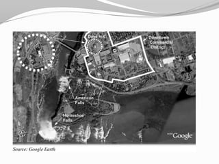
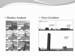
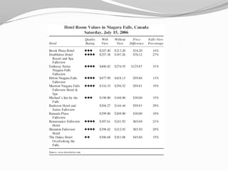
Assessing Visibility by Using 3D Visualization and GIS Tec. For Hotel Development in Niagara, NYPresented By:Abdullah Almodian
ContentsBackgroundBuilding RestrictionsThe Study GoalsThe ToolsQuestions
Assessing Visibility by Using 3D Visualization and GIS Tec. For Hotel Development in Niagara, NYBackground:-Millions of visitors every year come to visit the City of Niagara Falls, NY which is about 25 miles north of Buffalo, NY. The City has also the first world wonder state park in the US.-Niagara Falls, NY suffered from lack of government investment in tourism in the past. But yeas ago, government has rebuilt the whole area.Building Restrictions:- The tourist district of Niagara Falls limit hotel development to low-rise bulky type.-The maximum height is 20 stories or 200 feet - The typical commercial story is 13 feet which makes it 15 stories
Continued……-The building height restrictions may be based on an assumption that tall buildings block view corridors and cast potentially harmful shadows on surrounding properties.
 The StudyThe Goals:-GIS and 3D visualization technologies helps the tourist district of downtown Niagara Falls, NY to assess the visibility of Niagara Falls, the Horseshoe Falls in particular.-Examine how a hotel could capitalize on views of the Falls and help revitalize the districtThe Tools:GIS maps and a 3D model of the city and the Falls were created using both ArcScene and Sketchup to :-Explore and analyze view potentials -Compare view corridors-Examine shadow effects assuming that existing height regulations could be revised to allow high-rise hotels.
Continued……Why ArcScene & Sketchup:Simple and user-friendly developed to be an alternative to AutoCAD & 3D StudioMAXPowerful tool for creating, viewing, modifying, and communicating 3D ideas quickly and easilyWork with most other modeling, image editing, illustration applications, and GIS softwareIt is quick and easy to make changes in Sketchup
Shadow AnalysisView Corridors
QuestionsThis would possibly help rejunuate the area economically and even give better corridors views as fiqure 6 depicts in the article.  What are your thoughts?Do you feel it can be a valuable tool for other projects?What is the cost range to perform a GIS and 3-D modeling study?

3 d visualization and gis

  • 1.
    Assessing Visibility byUsing 3D Visualization and GIS Tec. For Hotel Development in Niagara, NYPresented By:Abdullah Almodian
  • 2.
  • 3.
    Assessing Visibility byUsing 3D Visualization and GIS Tec. For Hotel Development in Niagara, NYBackground:-Millions of visitors every year come to visit the City of Niagara Falls, NY which is about 25 miles north of Buffalo, NY. The City has also the first world wonder state park in the US.-Niagara Falls, NY suffered from lack of government investment in tourism in the past. But yeas ago, government has rebuilt the whole area.Building Restrictions:- The tourist district of Niagara Falls limit hotel development to low-rise bulky type.-The maximum height is 20 stories or 200 feet - The typical commercial story is 13 feet which makes it 15 stories
  • 4.
    Continued……-The building heightrestrictions may be based on an assumption that tall buildings block view corridors and cast potentially harmful shadows on surrounding properties.
  • 5.
    The StudyTheGoals:-GIS and 3D visualization technologies helps the tourist district of downtown Niagara Falls, NY to assess the visibility of Niagara Falls, the Horseshoe Falls in particular.-Examine how a hotel could capitalize on views of the Falls and help revitalize the districtThe Tools:GIS maps and a 3D model of the city and the Falls were created using both ArcScene and Sketchup to :-Explore and analyze view potentials -Compare view corridors-Examine shadow effects assuming that existing height regulations could be revised to allow high-rise hotels.
  • 6.
    Continued……Why ArcScene &Sketchup:Simple and user-friendly developed to be an alternative to AutoCAD & 3D StudioMAXPowerful tool for creating, viewing, modifying, and communicating 3D ideas quickly and easilyWork with most other modeling, image editing, illustration applications, and GIS softwareIt is quick and easy to make changes in Sketchup
  • 8.
  • 10.
    QuestionsThis would possiblyhelp rejunuate the area economically and even give better corridors views as fiqure 6 depicts in the article.  What are your thoughts?Do you feel it can be a valuable tool for other projects?What is the cost range to perform a GIS and 3-D modeling study?