Download free for 30 days
Sign in
Upload
Language (EN)
Support
Business
Mobile
Social Media
Marketing
Technology
Art & Photos
Career
Design
Education
Presentations & Public Speaking
Government & Nonprofit
Healthcare
Internet
Law
Leadership & Management
Automotive
Engineering
Software
Recruiting & HR
Retail
Sales
Services
Science
Small Business & Entrepreneurship
Food
Environment
Economy & Finance
Data & Analytics
Investor Relations
Sports
Spiritual
News & Politics
Travel
Self Improvement
Real Estate
Entertainment & Humor
Health & Medicine
Devices & Hardware
Lifestyle
Change Language
Language
English
Español
Português
Français
Deutsche
Cancel
Save
Submit search
EN
Uploaded by
Tom Hayakawa
PPT, PDF
333 views
2005 11 29_template_customize_seminer_04
2005年11月29日 Do XOOPS セミナー 株式会社ドゥ・ハウス 「XOOPS テンプレートをマスターしよう」
Read more
0
Save
Share
Embed
Embed presentation
Download
Download to read offline
1
/ 9
2
/ 9
3
/ 9
4
/ 9
5
/ 9
6
/ 9
7
/ 9
8
/ 9
9
/ 9
More Related Content
PDF
Cakephp2.1 ViewBlock view-inheritance
by
Kohji Tanaka
PDF
Try Jetpack
by
Hideaki Miyake
PDF
Symfony2からdoctrine mongo db odmを使ってみる
by
Koji Iwazaki
PDF
Jetpack Workshop
by
Hideaki Miyake
PDF
MT meets PHP
by
純生 野田
PDF
MT meets PHP - PHP conference Kansai 2013
by
純生 野田
PDF
Inside Movable Type
by
純生 野田
PDF
やはりお前らのMTMLは間違っている!
by
純生 野田
Cakephp2.1 ViewBlock view-inheritance
by
Kohji Tanaka
Try Jetpack
by
Hideaki Miyake
Symfony2からdoctrine mongo db odmを使ってみる
by
Koji Iwazaki
Jetpack Workshop
by
Hideaki Miyake
MT meets PHP
by
純生 野田
MT meets PHP - PHP conference Kansai 2013
by
純生 野田
Inside Movable Type
by
純生 野田
やはりお前らのMTMLは間違っている!
by
純生 野田
Viewers also liked
PPT
2010 09 08_nagoya-cu_osm
by
Tom Hayakawa
PPS
LUGARES - Veneza e as chuvas*
by
Cristiane Freitas
PPS
Passaros incansaveis*
by
Cristiane Freitas
PDF
2012 05 12_osc2012_nagoya_osm
by
Tom Hayakawa
PPT
2009 11 13_osm-tokai
by
Tom Hayakawa
PPS
REFLEXAO - La bordadora del hierro*
by
Cristiane Freitas
PDF
Introductie HollandLeert
by
Paul Alders
PPT
2007 10 27_fsij_xc-tokai
by
Tom Hayakawa
PPT
2009 08 08_wcan_xcl
by
Tom Hayakawa
2010 09 08_nagoya-cu_osm
by
Tom Hayakawa
LUGARES - Veneza e as chuvas*
by
Cristiane Freitas
Passaros incansaveis*
by
Cristiane Freitas
2012 05 12_osc2012_nagoya_osm
by
Tom Hayakawa
2009 11 13_osm-tokai
by
Tom Hayakawa
REFLEXAO - La bordadora del hierro*
by
Cristiane Freitas
Introductie HollandLeert
by
Paul Alders
2007 10 27_fsij_xc-tokai
by
Tom Hayakawa
2009 08 08_wcan_xcl
by
Tom Hayakawa
Similar to 2005 11 29_template_customize_seminer_04
PPT
2005 07 30_xwj_customizinig
by
Tom Hayakawa
PPT
2005 09 17_osc2005_xoops
by
Tom Hayakawa
PPT
2005 10 07_kof2005_xoops
by
Tom Hayakawa
PPT
2005 05 21_xoops_xev4_customizing
by
Tom Hayakawa
PDF
Xoopsサイト制作セミナー 20120922
by
Toshihiro Takehara
PPT
2006 03 18_osc2006_x_cube_template
by
Tom Hayakawa
PPTX
開発初心者のためのMoodleプラグインの開発と利用(第二部) for Moodle Moot 2015
by
Shigeharu Yamaoka
KEY
Cmsインサイド 120801 公開版
by
株式会社RYUS
PDF
XOOPS Cube Conference 2012 Developer Workshop 4
by
Hikawa Kilica
2005 07 30_xwj_customizinig
by
Tom Hayakawa
2005 09 17_osc2005_xoops
by
Tom Hayakawa
2005 10 07_kof2005_xoops
by
Tom Hayakawa
2005 05 21_xoops_xev4_customizing
by
Tom Hayakawa
Xoopsサイト制作セミナー 20120922
by
Toshihiro Takehara
2006 03 18_osc2006_x_cube_template
by
Tom Hayakawa
開発初心者のためのMoodleプラグインの開発と利用(第二部) for Moodle Moot 2015
by
Shigeharu Yamaoka
Cmsインサイド 120801 公開版
by
株式会社RYUS
XOOPS Cube Conference 2012 Developer Workshop 4
by
Hikawa Kilica
More from Tom Hayakawa
PDF
2014 07 23 豊橋IT勉強会
by
Tom Hayakawa
PDF
2014 07 05 OSC2014Nagoya
by
Tom Hayakawa
PDF
2013/12/07 浜松勉強会_osm-edit
by
Tom Hayakawa
PDF
2013 12 02_osm 浜松セミナー
by
Tom Hayakawa
PDF
JOSM資料
by
Tom Hayakawa
PDF
OpenStreetMap資料
by
Tom Hayakawa
PDF
2013 02 09_osc2013_hamamatsu_osm
by
Tom Hayakawa
PDF
2012 12 08_ngk_osm_a
by
Tom Hayakawa
PDF
2012 09 06_sot_m_osm
by
Tom Hayakawa
PDF
2012 09 06_sot_m_osm_tokai
by
Tom Hayakawa
PDF
2012 08 11_josm-hamamatsu
by
Tom Hayakawa
PDF
2012 08 11_osm_hamamatsu
by
Tom Hayakawa
PDF
2012 07 28_osm_ws3
by
Tom Hayakawa
PDF
2012 07 27_osm_project10
by
Tom Hayakawa
PDF
2012 07 27_geo_mediasumit_lt
by
Tom Hayakawa
PDF
2012 07 14_osm-ws_2
by
Tom Hayakawa
PDF
2012 06 30_osm-ws_1a
by
Tom Hayakawa
PDF
2012 04 14_foss4_g_nagoya_osm
by
Tom Hayakawa
PPT
2011 08 09_open_streetmap_general
by
Tom Hayakawa
PPT
2011 06 18_osmfj_osm-tokai
by
Tom Hayakawa
2014 07 23 豊橋IT勉強会
by
Tom Hayakawa
2014 07 05 OSC2014Nagoya
by
Tom Hayakawa
2013/12/07 浜松勉強会_osm-edit
by
Tom Hayakawa
2013 12 02_osm 浜松セミナー
by
Tom Hayakawa
JOSM資料
by
Tom Hayakawa
OpenStreetMap資料
by
Tom Hayakawa
2013 02 09_osc2013_hamamatsu_osm
by
Tom Hayakawa
2012 12 08_ngk_osm_a
by
Tom Hayakawa
2012 09 06_sot_m_osm
by
Tom Hayakawa
2012 09 06_sot_m_osm_tokai
by
Tom Hayakawa
2012 08 11_josm-hamamatsu
by
Tom Hayakawa
2012 08 11_osm_hamamatsu
by
Tom Hayakawa
2012 07 28_osm_ws3
by
Tom Hayakawa
2012 07 27_osm_project10
by
Tom Hayakawa
2012 07 27_geo_mediasumit_lt
by
Tom Hayakawa
2012 07 14_osm-ws_2
by
Tom Hayakawa
2012 06 30_osm-ws_1a
by
Tom Hayakawa
2012 04 14_foss4_g_nagoya_osm
by
Tom Hayakawa
2011 08 09_open_streetmap_general
by
Tom Hayakawa
2011 06 18_osmfj_osm-tokai
by
Tom Hayakawa
2005 11 29_template_customize_seminer_04
1.
TinyD プラグイン TinyD
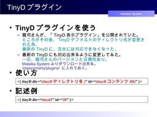
プラグインを使う 龍司さんが、「 TinyD 表示プラグイン」を公開されていた。 ところがその後、 TinyD デフォルトのディレクトリ名が変更された為、 最新の TinyD に、完全には対応できなくなった。 最新の TinyD にも対応出来るように変更してみた。 一応、龍司さんのバージョンと互換性あり。 Malaika System よりダウンロード出来る。 /class/smarty/plugins/ に入れておく。 <{ tinyD dir=“ (tinyD ディレクトリ名 ) ” id=“ (tinyD コンテンツ ID) ” }> 使い方 <{ tinyD dir=“ tinyd1 ” id=“ 20 ” }> 記述例
2.
TinyD をテーマに使う (
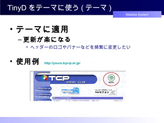
テーマ ) テーマに適用 更新が楽になる ヘッダーのロゴやバナーなどを頻繁に変更したい 使用例 http://yours.tcp-ip.or.jp/
3.
TinyD をテーマに使う (
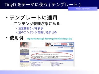
テンプレート ) 使用例 http://www. kasugai-komaki . jp /modules/ xoopsfaq / テンプレートに適用 コンテンツ管理が楽になる 注意書きなどを表示 別のコンテンツを割り込ませる
4.
xoops_block プラグイン Xoops_block
プラグイン 「どこでもブロック」プラグイン ? (^^ ゞ テーマ・テンプレートなどの Smarty レベル上であれば、 どこでもブロック関数を呼び出して表示できる。 テーマの通常のブロック表示エリア以外(ヘッダー・フッターなど)にも ブロックを呼び出し表示できる。 ブロックのテンプレートに使えば、ニコイチブロックが出来る。 コンテンツの中に、ブロックを表示する事も可能になる。 ブロック関数を呼出し、 Smarty 変数にアサインしてるだけ 自由にレイアウト可能 上級者向けではあるが、使いこなせれば超強力 ・・・・・・かも (^^ ゞ
5.
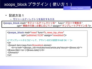
xoops_block プラグイン(使い方 1
) 記述方法1 モジュールディレクトリを指定する方法 <{ xoops_block mod=“ モジュールディレクトリ名 ” func=“ ブロック関数名 ” opt=“ 関数の引数 ( 必要に応じて ) " assign=" テンプレートアサイン名 "}> <{ xoops_block mod=" news " func=" b_news_top_show " opt=“ published,10,50 ” assign=“ newsblock ”}> <{* テンプレートからコピーして、アサイン名だけ変更すれば OK ! *}> <ul> <{foreach item=news from= $newsblock .stories}> <li><a href="<{$xoops_url}>/modules/news/article.php?storyid=<{$news.id}>"> <{$news.title}></a> (<{$news.date}>)</li> <{/foreach}> </ul>
6.
xoops_block プラグイン(使い方2) 記述方法2
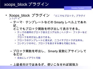
ブロック関数が記述されたファイルを直接指定する方法 <{ xoops_block file=“ ブロック関数が記述されたファイル ” func=“ ブロック関数名 ” opt=“ 関数の引数 ( 必要に応じて ) " assign=" テンプレートアサイン名 "}> <{ xoops_block file =“ modules/news/block/news_top.php " func=" b_news_top_show " opt=“ published,10,50 ” assign=“ newsblock ”}> <{* テンプレートからコピーして、アサイン名だけ変更すれば OK ! *}> <ul> <{foreach item=news from= $newsblock .stories}> <li><a href="<{$xoops_url}>/modules/news/article.php?storyid=<{$news.id}>"> <{$news.title}></a> (<{$news.date}>)</li> <{/foreach}> </ul> [ 裏技 ] ブロック関数の記述ルールに沿っていれば、独自関数も使用できる。 <{ xoops_block file =“ myfunction .php " func=“ my_xxxx_show " assign=“ myblock ”}>
7.
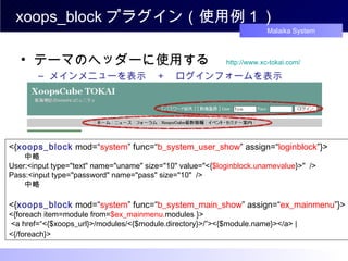
xoops_block プラグイン(使用例1) テーマのヘッダーに使用する
http://www.xc-tokai.com/ メインメニューを表示 + ログインフォームを表示 <{ xoops_block mod=“ system ” func=“ b_system_user_show ” assign=“ loginblock ”}> 中略 User:<input type="text" name="uname" size="10" value="<{ $loginblock.unamevalue }>" /> Pass:<input type="password" name="pass" size="10" /> 中略 <{ xoops_block mod=“ system ” func=“ b_system_main_show ” assign=“ ex_mainmenu ”}> <{foreach item=module from= $ex_mainmenu. modules }> <a href=“<{$xoops_url}>/modules/<{$module.directory}>/”><{$module.name}></a> | <{/foreach}>
8.
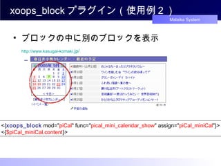
xoops_block プラグイン(使用例2) ブロックの中に別のブロックを表示
http://www.kasugai-komaki .jp/ piCal ミニカレンダーを表示する <{ xoops_block mod=" piCal " func=" pical_mini_calendar_show " assign=" piCal_miniCal "}> <{ $piCal_miniCal.content }>
9.
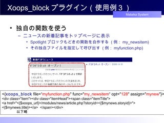
Xoops_block プラグイン(使用例3) 独自の関数を使う
ニュースの新着記事をトップページに表示 Spotlight ブロックもどきの関数を自作する ( 例: my_newsitem) その独自ファイルを指定して呼び出す ( 例: myfunction.php) <{ xoops_block file=“ myfunction.php " func=" my_newsitem “ opt=" 128 " assign=" mynew "}> <div class="item"><div class="itemHead"><span class="itemTitle"> <a href="<{$xoops_url}>/modules/news/article.php?storyid=<{$mynews.storyid}>"> <{$mynews.title}></a> </span></div> 以下略
Editor's Notes
#2
実は、龍司さんが tinyD のコンテンツをテーマなどで表示出来るような、 Smarty プラグインを公開されていたんですが、 その後に、 tinyD のデフォルトのディレクトリ名が変更になり、また、ディレクトリ名が柔軟に変更可能になりましたので、 龍司さんの Smarty プラグインは、 TinyD 最新版に対して、完全には対応しきれなくなってしまっていました。 それで、ちょっと、最新版 TinyD に対応出来るように変更を加えてみましたので、それを使ってみる事にします。 その Smarty プラグインは、私のサイトよりダウンロード可能ですので、宜しかったらダウンロードしてみてください。 ダウンロード後、解凍してから、 XOOPS ルートディレクリの class/smarty/plugins/ に入れていただければ、使用可能になります。 また、龍司さんのバージョンとも互換性を維持している筈ですので、上書きされれば使えます。 使い方は、簡単で、 TinyD ディレクトリ名 と コンテンツIDを指定するだけです。こんな感じですね。 では、実際の使用例を見てみましょう。
#3
で、どうゆうところで、活用でするのか・・・・。 テーマでは、ヘッダーやロゴなど、頻繁に変更したいような時に活用すると便利かと思います。 「 TCP-IP 」 は、テーマ内に使った例です。 ちょっと、言われなければ気が付かないかもしれませんが、この画像がそれです。 通常は、こんなところは、テーマに直接書いちゃう、ところかと思いますが、 この方法で表示する事により、画像などの変更が管理画面からできますので、大変便利になったと思います。 他にも、応用例として、 さっきのモジュールの判別の方法と併用すれば、モジュール毎に表示を変えたりも可能ですし、 また、もしかしたら、 Google アドセンスとかでも、面白い使い方があるかもしれませんね。
#4
テンプレート使ってみる場合ですと・・・・、 ちょっとした文章だったら、直接テンプレートに書き込んでも良いかもしれませんが、 まとまった文章や、頻繁に変更したいような文章とかだったら、この方法の方が管理しやすいかと思います。 こんな感じで、注意書きなどを tinyD で書いて、それをテンプレート内に表示しています。 応用例としては、ユーザー毎に表示を変えたりとかも、その気になれば可能ですよね。 Smaty プラグインさえ入れていれば、比較的簡単に、このワザは使えますし、応用範囲は広いと思います。
#7
なぜ、この記述方法も使えるようにしたのかと言うと・・、 ・直接、ファイルを呼び出すので、 SQL を回さずに使える。(理論上は、こっちの方が軽い筈です。) ・裏技的に、独自の関数を使う事が出来る。
#8
ログインフォームなどは、フォームを直接記述すれば良いように思われるが、 その場合、クッキーを呼び出すことが出来ない。
#9
たった、これだけで、どこにでも、 piCal ミニカレンダーを表示出来ます。 幸か不幸か (^^ ゞ、 piCal ミニカレンダーはテンプレートに対応してませんので、簡単に記述できます。
Download
![xoops_block プラグイン(使い方2) 記述方法2 ブロック関数が記述されたファイルを直接指定する方法 <{ xoops_block file=“ ブロック関数が記述されたファイル ” func=“ ブロック関数名 ” opt=“ 関数の引数 ( 必要に応じて ) " assign=" テンプレートアサイン名 "}> <{ xoops_block file =“ modules/news/block/news_top.php " func=" b_news_top_show " opt=“ published,10,50 ” assign=“ newsblock ”}> <{* テンプレートからコピーして、アサイン名だけ変更すれば OK ! *}> <ul> <{foreach item=news from= $newsblock .stories}> <li><a href="<{$xoops_url}>/modules/news/article.php?storyid=<{$news.id}>"> <{$news.title}></a> (<{$news.date}>)</li> <{/foreach}> </ul> [ 裏技 ] ブロック関数の記述ルールに沿っていれば、独自関数も使用できる。 <{ xoops_block file =“ myfunction .php " func=“ my_xxxx_show " assign=“ myblock ”}>](https://image.slidesharecdn.com/20051129templatecustomizeseminer04-111218061934-phpapp02/85/2005-11-29_template_customize_seminer_04-6-320.jpg)