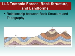
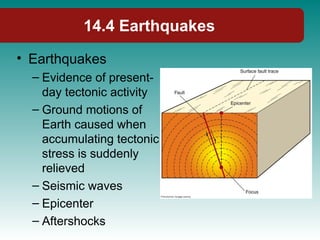
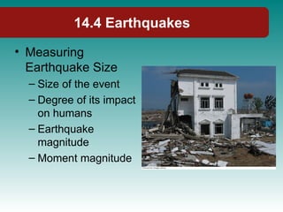
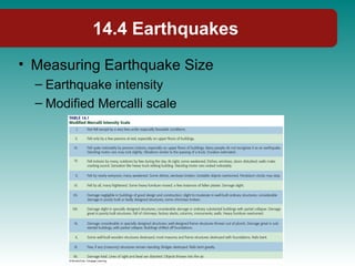
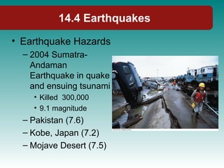
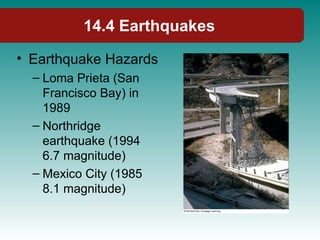
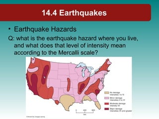
Chapter 14: Volcanic and Tectonic
Processes and Landforms
Physical Geography
Physical Geography
Ninth Edition
Ninth Edition
Robert E. Gabler
James. F. Petersen
L. Michael Trapasso
Dorothy Sack
Volcanic and Tectonic Processes and
Landforms
Volcanic and Tectonic Processes and
Landforms
• Topography: distribution of landscape
(mountains, plains, hills, valleys, plateaus)
• Landforms: surface terrain features
• Geomorphology
– Understanding landforms and landscapes
– Seek explanations for the shape, origin,
spatial distribution, and development of terrain
features
– Igneous processes and tectonic processes
14.1 Landforms and Geomorphology
• Relief
– Low relief (e.g. western Utah)
– High relief (e.g. Great Basin, Rockies, Himalayas)
14.1 Landforms and Geomorphology
• Geomorphic Processes
– Endogenic processes: originate within earth and
result in an increase in surface relief
– Exogenic processes: originate at Earth’s
surface, tend to decrease relief
• Examples:
– Weathering
– Erosion
– Transportation
– Deposition
– Geomorphic agent (e.g. flowing water or ice)
14.1 Landforms and Geomorphology
• Rising Relief:
– Endogenic processes
greater than exogenic
processes
– Grand Tetons, Wyoming
• Punctuated Equilibrium
– Examples:
• Earthquakes
• Volcanic eruption
• Exogenic processes (e.g.
flood)
14.1 Landforms and Geomorphology
• Punctuated Equilibrium
– Mt. Vesuvius
14.2 Igneous Processes and
Landforms
• Landforms resulting from
igneous processes are
related to:
– Volcanism (extrusive)
• Volcanoes
– Plutonism (below Earth’s
surface)
14.2 Igneous Processes and
Landforms
• Volcanic Eruptions
– Natural processes
– Large eruptions can be
devastating
– Vary greatly in size and
character
– Resulting landform varies
– Two main types of Eruptions:
• Explosive
• Effusive
14.2 Igneous Processes and
Landforms
• Nature of Volcanic Eruption
dependent on:
– Mineral composition
• Silica rich felsic (cool, thick,
resistant to flowing)
• Mafic (very hot, flows readily)
• Silica rich magmas with rhyolite
(violent eruption)
• Basaltic (effusive)
– Pressure
– Pyroclastic materials (ash and
tephra)
14.2 Igneous Processes and
Landforms
• Volcanic Landforms
– Depends primarily on explosiveness
– 6 major kinds (least explosive to most explosive)
• Lava flows
• Shield Volcanoes
• Cinder Cones
• Composite Cones
• Plug Domes
• Calderas
14.2 Igneous Processes and
Landforms
• Lava Flows
– Basalt is the most
common
– Small potential for
explosive eruption
– Joints and columnar-
jointed basalt flows
– Pahoehoe
14.2 Igneous Processes and
Landforms
• Lava Flows
– Aa
– Fissures
– Flood basalts
– Basalt plateaus
• Columbia plateau
• Deccan plateau in
India
14.2 Igneous Processes and
Landforms
• Shield Volcanoes
– Numerous basaltic
lava flows piling up
– Gently sloping, dome
shaped cone
– Hawaii
– Not very explosive,
but still damaging
14.2 Igneous Processes and
Landforms
• Shield Volcanoes
Q: Why do Hawaiian volcanoes erupt less explosively than
volcanoes of the Andes or Cascades?
14.2 Igneous Processes and
Landforms
• Cinder Cones
– Smallest type of
volcano
– Rhyolite composition
– Steep, straight sides
and a large crater in
the center
– Examples:
• Craters of the Moon,
ID
• Sunset Crater, AZ
14.2 Igneous Processes and
Landforms
• Composite Cones
– Effusive or explosive
– Composite of lava and
pyroclastic
– Stratovolcanoes
– Pyroclastic flows
– Concave slopes that are
gently near the base and
steep near the top
– Fujiyama, Vesuvius,
Rainer, Mt. St Helens
14.2 Igneous Processes and
Landforms
• Composite Cones
Q: Could other volcanoes
in the Cascade Range,
such as Oregon’s Mount
Hood, erupt with the kind
of violence that Mount St.
Helen’s displayed in
1980?
14.2 Igneous Processes and
Landforms
• Composite Cones
– Examples:
• Krakotoa (1883 and
subsequent tsunami)
• Mount Pinatubo
(1991)
• Many died in both
events above.
– Mexico City is
threatened
14.2 Igneous Processes and
Landforms
• Plug Domes
– Viscous silica-rich
magma pushed into a
vent
– Dome shaped summit
and jagged blocks
make up cone on
steep sloping sides
– Lassen Peak, CA
14.2 Igneous Processes and
Landforms
• Calderas
– Large
depression
– Crater Lake
– Yellowstone
14.2 Igneous Processes and
Landforms
• Plutonism and
Intrusions
– Igneous intrusions
(plutons)
– Classified by size,
shape, and
relationships to
surrounding rocks
– Stock
– Laccolith
14.2 Igneous Processes and
Landforms
• Examples of
Laccoliths
– Henry and La Sal
Mountains in S. Utah
• Sill
– Palisades along
Hudson River, NY
14.2 Igneous Processes and
Landforms
• Dike
– New Mexico
• Volcanic Neck
– Shiprock, New
Mexico
14.3 Tectonic Forces, Rock Structure,
and Landforms
• Rock Structure
– Nature
– Orientation
– Inclination
– Arrangement of
affected rock layers
– Strike
– Dip
14.3 Tectonic Forces, Rock Structure,
and Landforms
• 3 Principal Tectonic
Forces:
– Compressional
– Tensional
– Shearing
14.3 Tectonic Forces, Rock Structure,
and Landforms
• Compressional
Tectonic Forces
– Folding (e.g.
Appalachians,
Rockies)
– Anticlines
– Synclines
– Recumbent folds
14.3 Tectonic Forces, Rock Structure,
and Landforms
• Compressional
Tectonic Forces
– Faulting
– Reverse Fault
– Fault
– Thrust fault
– Overthrust
14.3 Tectonic Forces, Rock Structure,
and Landforms
• Tensional Tectonic
Forces
– Fault blocks
– Normal faults
– Graben and Horst
(e.g. Great Basin)
14.3 Tectonic Forces, Rock Structure,
and Landforms
• Tensional Tectonic
Forces
– Tilted fault blocks
(e.g. Death Valley)
– Rift valleys
• Rift Valley of east
Africa
• Rio Grande rift
14.3 Tectonic Forces, Rock Structure,
and Landforms
• Tensional Tectonic
Forces
– Escarpment (scarp)
– Fault scarp
• Eastern Sierra
Nevada
• Grand Tetons
– Piedmont fault
scarps
14.3 Tectonic Forces, Rock Structure,
and Landforms
• Shearing Tectonic
Forces
– Dip-slip faults
– Strike-slip faults
– Lateral fault
• San Andreas Fault
• 1906 san Francisco
Earthquake
14.3 Tectonic Forces, Rock Structure,
and Landforms
• Relationship between Rock Structure and
Topography
14.4 Earthquakes
• Earthquakes
– Evidence of present-
day tectonic activity
– Ground motions of
Earth caused when
accumulating tectonic
stress is suddenly
relieved
– Seismic waves
– Epicenter
– Aftershocks
14.4 Earthquakes
• Measuring
Earthquake Size
– Size of the event
– Degree of its impact
on humans
– Earthquake
magnitude
– Moment magnitude
14.4 Earthquakes
• Measuring Earthquake Size
– Earthquake intensity
– Modified Mercalli scale
14.4 Earthquakes
• Earthquake Hazards
– 2004 Sumatra-
Andaman
Earthquake in quake
and ensuing tsunami
• Killed 300,000
• 9.1 magnitude
– Pakistan (7.6)
– Kobe, Japan (7.2)
– Mojave Desert (7.5)
14.4 Earthquakes
• Earthquake Hazards
– Loma Prieta (San
Francisco Bay) in
1989
– Northridge
earthquake (1994
6.7 magnitude)
– Mexico City (1985
8.1 magnitude)
14.4 Earthquakes
• Earthquake Hazards
Q: what is the earthquake hazard where you live,
and what does that level of intensity mean
according to the Mercalli scale?
Physical Geography
End of Chapter 14: Volcanic and
Tectonic Processes and Landforms

14-11021asdaddasadsdasd7020243-phpapp02.ppt

  • 1.
    Chapter 14: Volcanicand Tectonic Processes and Landforms Physical Geography Physical Geography Ninth Edition Ninth Edition Robert E. Gabler James. F. Petersen L. Michael Trapasso Dorothy Sack
  • 2.
    Volcanic and TectonicProcesses and Landforms
  • 3.
    Volcanic and TectonicProcesses and Landforms • Topography: distribution of landscape (mountains, plains, hills, valleys, plateaus) • Landforms: surface terrain features • Geomorphology – Understanding landforms and landscapes – Seek explanations for the shape, origin, spatial distribution, and development of terrain features – Igneous processes and tectonic processes
  • 4.
    14.1 Landforms andGeomorphology • Relief – Low relief (e.g. western Utah) – High relief (e.g. Great Basin, Rockies, Himalayas)
  • 5.
    14.1 Landforms andGeomorphology • Geomorphic Processes – Endogenic processes: originate within earth and result in an increase in surface relief – Exogenic processes: originate at Earth’s surface, tend to decrease relief • Examples: – Weathering – Erosion – Transportation – Deposition – Geomorphic agent (e.g. flowing water or ice)
  • 6.
    14.1 Landforms andGeomorphology • Rising Relief: – Endogenic processes greater than exogenic processes – Grand Tetons, Wyoming • Punctuated Equilibrium – Examples: • Earthquakes • Volcanic eruption • Exogenic processes (e.g. flood)
  • 7.
    14.1 Landforms andGeomorphology • Punctuated Equilibrium – Mt. Vesuvius
  • 8.
    14.2 Igneous Processesand Landforms • Landforms resulting from igneous processes are related to: – Volcanism (extrusive) • Volcanoes – Plutonism (below Earth’s surface)
  • 9.
    14.2 Igneous Processesand Landforms • Volcanic Eruptions – Natural processes – Large eruptions can be devastating – Vary greatly in size and character – Resulting landform varies – Two main types of Eruptions: • Explosive • Effusive
  • 10.
    14.2 Igneous Processesand Landforms • Nature of Volcanic Eruption dependent on: – Mineral composition • Silica rich felsic (cool, thick, resistant to flowing) • Mafic (very hot, flows readily) • Silica rich magmas with rhyolite (violent eruption) • Basaltic (effusive) – Pressure – Pyroclastic materials (ash and tephra)
  • 11.
    14.2 Igneous Processesand Landforms • Volcanic Landforms – Depends primarily on explosiveness – 6 major kinds (least explosive to most explosive) • Lava flows • Shield Volcanoes • Cinder Cones • Composite Cones • Plug Domes • Calderas
  • 12.
    14.2 Igneous Processesand Landforms • Lava Flows – Basalt is the most common – Small potential for explosive eruption – Joints and columnar- jointed basalt flows – Pahoehoe
  • 13.
    14.2 Igneous Processesand Landforms • Lava Flows – Aa – Fissures – Flood basalts – Basalt plateaus • Columbia plateau • Deccan plateau in India
  • 14.
    14.2 Igneous Processesand Landforms • Shield Volcanoes – Numerous basaltic lava flows piling up – Gently sloping, dome shaped cone – Hawaii – Not very explosive, but still damaging
  • 15.
    14.2 Igneous Processesand Landforms • Shield Volcanoes Q: Why do Hawaiian volcanoes erupt less explosively than volcanoes of the Andes or Cascades?
  • 16.
    14.2 Igneous Processesand Landforms • Cinder Cones – Smallest type of volcano – Rhyolite composition – Steep, straight sides and a large crater in the center – Examples: • Craters of the Moon, ID • Sunset Crater, AZ
  • 17.
    14.2 Igneous Processesand Landforms • Composite Cones – Effusive or explosive – Composite of lava and pyroclastic – Stratovolcanoes – Pyroclastic flows – Concave slopes that are gently near the base and steep near the top – Fujiyama, Vesuvius, Rainer, Mt. St Helens
  • 18.
    14.2 Igneous Processesand Landforms • Composite Cones Q: Could other volcanoes in the Cascade Range, such as Oregon’s Mount Hood, erupt with the kind of violence that Mount St. Helen’s displayed in 1980?
  • 19.
    14.2 Igneous Processesand Landforms • Composite Cones – Examples: • Krakotoa (1883 and subsequent tsunami) • Mount Pinatubo (1991) • Many died in both events above. – Mexico City is threatened
  • 20.
    14.2 Igneous Processesand Landforms • Plug Domes – Viscous silica-rich magma pushed into a vent – Dome shaped summit and jagged blocks make up cone on steep sloping sides – Lassen Peak, CA
  • 21.
    14.2 Igneous Processesand Landforms • Calderas – Large depression – Crater Lake – Yellowstone
  • 22.
    14.2 Igneous Processesand Landforms • Plutonism and Intrusions – Igneous intrusions (plutons) – Classified by size, shape, and relationships to surrounding rocks – Stock – Laccolith
  • 23.
    14.2 Igneous Processesand Landforms • Examples of Laccoliths – Henry and La Sal Mountains in S. Utah • Sill – Palisades along Hudson River, NY
  • 24.
    14.2 Igneous Processesand Landforms • Dike – New Mexico • Volcanic Neck – Shiprock, New Mexico
  • 25.
    14.3 Tectonic Forces,Rock Structure, and Landforms • Rock Structure – Nature – Orientation – Inclination – Arrangement of affected rock layers – Strike – Dip
  • 26.
    14.3 Tectonic Forces,Rock Structure, and Landforms • 3 Principal Tectonic Forces: – Compressional – Tensional – Shearing
  • 27.
    14.3 Tectonic Forces,Rock Structure, and Landforms • Compressional Tectonic Forces – Folding (e.g. Appalachians, Rockies) – Anticlines – Synclines – Recumbent folds
  • 28.
    14.3 Tectonic Forces,Rock Structure, and Landforms • Compressional Tectonic Forces – Faulting – Reverse Fault – Fault – Thrust fault – Overthrust
  • 29.
    14.3 Tectonic Forces,Rock Structure, and Landforms • Tensional Tectonic Forces – Fault blocks – Normal faults – Graben and Horst (e.g. Great Basin)
  • 30.
    14.3 Tectonic Forces,Rock Structure, and Landforms • Tensional Tectonic Forces – Tilted fault blocks (e.g. Death Valley) – Rift valleys • Rift Valley of east Africa • Rio Grande rift
  • 31.
    14.3 Tectonic Forces,Rock Structure, and Landforms • Tensional Tectonic Forces – Escarpment (scarp) – Fault scarp • Eastern Sierra Nevada • Grand Tetons – Piedmont fault scarps
  • 32.
    14.3 Tectonic Forces,Rock Structure, and Landforms • Shearing Tectonic Forces – Dip-slip faults – Strike-slip faults – Lateral fault • San Andreas Fault • 1906 san Francisco Earthquake
  • 33.
    14.3 Tectonic Forces,Rock Structure, and Landforms • Relationship between Rock Structure and Topography
  • 34.
    14.4 Earthquakes • Earthquakes –Evidence of present- day tectonic activity – Ground motions of Earth caused when accumulating tectonic stress is suddenly relieved – Seismic waves – Epicenter – Aftershocks
  • 35.
    14.4 Earthquakes • Measuring EarthquakeSize – Size of the event – Degree of its impact on humans – Earthquake magnitude – Moment magnitude
  • 36.
    14.4 Earthquakes • MeasuringEarthquake Size – Earthquake intensity – Modified Mercalli scale
  • 37.
    14.4 Earthquakes • EarthquakeHazards – 2004 Sumatra- Andaman Earthquake in quake and ensuing tsunami • Killed 300,000 • 9.1 magnitude – Pakistan (7.6) – Kobe, Japan (7.2) – Mojave Desert (7.5)
  • 38.
    14.4 Earthquakes • EarthquakeHazards – Loma Prieta (San Francisco Bay) in 1989 – Northridge earthquake (1994 6.7 magnitude) – Mexico City (1985 8.1 magnitude)
  • 39.
    14.4 Earthquakes • EarthquakeHazards Q: what is the earthquake hazard where you live, and what does that level of intensity mean according to the Mercalli scale?
  • 40.
    Physical Geography End ofChapter 14: Volcanic and Tectonic Processes and Landforms

Editor's Notes

  • #2 Insert cover image for Chapter 14 (p. 378).
  • #4 Insert Figure 14.1
  • #6 Insert Figure 14.2 and 14.3
  • #7 Insert Figure 14.4
  • #8 Insert Figure 14.5
  • #9 Insert Figure 14.5
  • #10 Insert Figure 14.6
  • #12 Insert Figure 14.7
  • #13 Insert Figure 14.8b and 14.9
  • #14 Insert Figure 14.10
  • #15 Insert Figure 14.11 and 14.12
  • #16 Insert Figure 14.13
  • #17 Insert Figure 14.14
  • #18 Insert Figure 14.15
  • #19 Insert Figure 14.16
  • #20 Insert Figure 14.17
  • #21 Insert Figure 14.18
  • #22 Insert Figure 14.19
  • #23 Insert Figure 14.20 and 14.21
  • #24 Insert Figure 14.22 and 14.23
  • #25 Insert Figure 14.24
  • #26 Insert Figure 14.25
  • #27 Insert Figure 14.26 and 14.27
  • #28 Insert Figure 14.28
  • #29 Insert Figure 14.29
  • #30 Insert Figure 14.30 and 14.31
  • #31 Insert Figure 14.32 and 14.33
  • #32 Insert Figure 14.28d and 14.35
  • #33 Insert Figure 14.36
  • #34 Insert Figure 14.37
  • #35 Insert Figure 14.38
  • #36 Insert Table 14.1
  • #37 Insert Figure 14.39
  • #38 Insert Figure 14.40
  • #39 Insert Figure 14.41