The Georges River begins near Appin, NSW, Australia and flows north through suburbs like Liverpool before emptying into Botany Bay. It has several tributaries and is used for recreation as well as commercial oyster farming. However, stormwater runoff from urban and rural areas pollutes the river with nutrients, metals, and organic compounds. A regional plan aims to improve the river's water quality and flows through coordinated management between local and state governments. Individual actions like reducing litter and government actions like improving stormwater infrastructure can help address pollution issues and protect the river catchment.
By Md. Rezaul Hasan, Md. Shamsuddin, Md. Sohel Masud, Dr. AFM Afzal Hossain (Institute of Water Modelling)
Revitalizing the Ganges Coastal Zone Conference
21-23 October 2014, Dhaka, Bangladesh
http://waterandfood.org/ganges-conference/
In recent years, Westport residents noticed that the salt marsh islands in the Westport Rivers, particularly in the West Branch, were disappearing rapidly. In response, the Westport Fishermen’s Association, the Buzzards Bay Coalition, the Marine Biological Laboratory Ecosystems Center, and the Buzzards Bay National Estuary Program partnered to measure the rate of salt marsh loss in the Westport Rivers and try to identify causes of this erosion
West Falmouth Nitrogen-Reducing Septic System Demonstration Project - May 201...Buzzards Bay Coalition
The West Falmouth Nitrogen-Reducing Septic System Demonstration Project illustrates how nitrogen pollution can be reduced by upgrading on-site septic systems and cesspools.
On 17 and 18 June 2020 the EPA held its National Water Event as an online conference.
This year's theme was 'Restoring our waters'.
This years event was free to attend. It was the EPA's largest water event ever, with over 1250 attending.
To everyone who joined us: thanks for attending; thanks for your probing questions; thanks for your passion; thanks for caring about our waters. We can achieve more working together.
Special thanks to all our presenters and the team who worked behind the scenes to make sure this years conference happened.
For science and stories about water quality in Ireland, check out www.catchments.ie
The Water Supply in Mumbai is quavering. Despite the fact that there are a large number of lakes situated within the city, Mumbaikars have to face water scarcity everyday.
To know more log on to http://www.ward64matters.com
Sand mining is the practice that is used to extract sand.Sand is mined from beaches,ocean beds and river beds.It is used in manufacturing cement,construction purpose etc.
Jennifer Birchfield, Water Program Director with Save the Dunes, will update the group on several news items and initiatives.
Save the Dunes in partnership with the city of Valparaiso, was recently awarded a $607,000 EPA grant to improve a large detention area located at Evans & Roosevelt in Valparaiso. The basin feeds into the Salt Creek watershed and eventually into Lake Michigan.
Birchfield said more than 500 acres of developed land drains into the 2-acre Thorgren basin after a storm. That water contains pollutants, such as lawn chemicals, oil and animal feces. The grant money will spur efforts to naturalize the basin to mimic a wetland surrounding to filter pollutants. Concrete will be replaced by a meandering waterway. Turfgrass will be replaced with native plantings that have deep roots that absorb water and pollutants.
Save the Dunes officials hope the Thorgren basin will become a model for other basins in the Lake Michigan watershed.
This presentation was given at the Catchment Management Network meeting on February 24th 2017. The Catchment Management Network consists of the EPA, all of Ireland's Local Authorities, and other public bodies involved in looking after Ireland's catchments, sub-catchments and water bodies. For more information about this work see www.catchments.ie
Jenny Deakin from the EPA Catchments Unit gave a Teagasc Signpost Seminar on April 20 2021. The seminar covered water quality, focused on the agricultural sector, and the solutions needed to improve water quality, and new tools to target the right measure in the right place. This includes upgraded Pollution Impact Potential Maps for Nitrogen and Phosphorus, together with overland flow and focused delivery points.
Sewage, or domestic/municipal wastewater, is a type of wastewater that is produced by a community of people. It is characterized by volume or rate of flow, physical condition, chemical and toxic constituents, and its bacteriologic status (which organisms it contains and in what quantities). It consists mostly of greywater (from sinks, bathtubs, showers, dishwashers, and clothes washers), blackwater (the water used to flush toilets, combined with the human waste that it flushes away); soaps and detergents; and toilet paper (less so in regions where bidets are widely used instead of paper).
ASSESSMENT OF WASTE WATER TREATMENT IN CANAANLAND, OTA, OGUN STATE, NIGERIA.O...Felix Oginni
Effluent from a sewage treatment plant in Covenant University, Canaanland is made to pass through a series of constructed wetland before discharging into a gully that drains into River Iju (also known as Atuara). This river is used as a source of drinking water and also provides food in form of fish for hundreds of thousands of people downstream and eventually enters the lagoon, some 60km away. Effectiveness and adequacy of the wastewater treatment facility in place was assessed in order to improve sanitation within this watershed, thereby alleviating environmental challenges in this coastal region of Nigeria. Waste water is gravity drained to the southwest portion of the campus where the solid is removed and the liquid is allowed to flow through six sets of constructed wetlands, each with four chambers. Within each chamber are water hyacinth plants put in place to remove nutrients from the waster water.
A quick survey of the facility shows the system to be effective in reducing and removing solids and dissolved solids from the waste water. The pH ranged between 6.6 and 6.8, conductivity from 530 to 600, and total dissolved solids (TDS) ranged from 360 – 400 ppm. The data obtained indicate that some modifications need to be made as the waste water treatment system is not very efficient in reducing the amount of TDS and nutrients. The flow rate is considered to be very high from cell to cell, thereby not allowing time for the plants and microbes to reduce the TDS. It is suggested that some method be devised to slow down the flow rate to allow the plants and microbes to work on reducing the TDS. Parameters also also considered included DO, E. Coli. Nitrate and Phosphates.
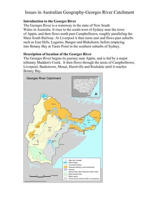
1. Issues in Australian Geography-Georges River Catchment
Introduction to the Georges River
The Georges River is a waterway in the state of New South
Wales in Australia. It rises to the south-west of Sydney near the town
of Appin, and then flows north past Campbelltown, roughly paralleling the
Main South Railway. At Liverpool it then turns east and flows past suburbs
such as East Hills, Lugarno, Bangor and Blakehurst, before emptying
into Botany Bay at Taren Point in the southern suburbs of Sydney.
Description of location of the Georges River
The Georges River begins its journey near Appin, and is fed by a major
tributary Madden's Creek. It then flows through the areas of Campbelltown,
Liverpool, Bankstown, Menai, Hurstville and Rockdale until it reaches
Botany Bay.
2. Major tributaries include Cabramatta Creek, Prospect Creek and the
Woronora River. The Georges River is popular for recreational activities
such as water skiing and swimming. The banks of the river along the lower
reaches are marked by large inlets and indentations overlooked by steep
sandstone ridges and scarps, many being home to expensive residential
properties.
The Georges River features some artificial lakes in the suburb of Chipping
Norton, near Liverpool. These lakes, known as the Chipping Norton Lakes,
are the result of sand mining. The Lakes are now a popular water sports and
recreational facility.
Geographical Processes relevant to the catchment
A catchment is an area where water is collected by the natural landscape. In
a catchment, all rain and run-off water eventually flows to a creek, river,
lake or ocean, or into the groundwater system.
3. Natural and human systems such as rivers, bushland, farms, dams, homes,
plants, animals and people can co-exist in a catchment.
Healthy catchments provide:
a source of clean drinking water
unspoilt natural areas for recreation and scenic enjoyment
habitat for plants and animals
healthy vegetation and waterways
reliable and clean water for stock and irrigation, and
Opportunities for sustainable agriculture and industry.
The Georges River is home to many different species of flora and fauna and
has a big biodiversity range. The Georges River is used for recreational
activities such as fishing, water skiing and boating, it is also used for
commercial oyster farming and the water from the Georges River connects
with the Woronora River which is then used for drinking water and water
around the house.
Fluvial processes comprise the motion of sediment and erosion of
or deposition on the river bed.
Erosion by moving water happens in two ways. First, the movement of water
across the bed has an effect (This is called hydraulic action). Second, the
sediment being transported in the river wears away the bed (Abrasion) and
the fragments themselves are ground down becoming smaller and more
rounded (Attrition).
The sediment is transported as either bedload (The coarser fragments which
move close to the bed) or as the suspended load (Finer fragments carried in
the water). There is also a component carried as dissolved material.
Storm water runoff & waste water issues
The water quality was not good enough to be drinkable. But it was
acceptable to swim in.
Test Type Test Results Acceptable Std
Chemical Phosphates 1 0-0.1 ppm
pH 7 6-8.3
Biological Faecal Coliform- <4 colonies per
Easgel 2.5ml
Physical Turbidity 10.15 <30 NTU
4. There were a few particles in the water at the time of testing and there was
little litter present.
There were no odours.
The major sources of pollution to the Georges River Estuary are stormwater
run off from urban areas including roads and open spaces, wet weather
sewer overflows, past contamination of land and sediment, and stormwater
run off from rural lands. These sources put metals, oils, grease, toxic
organic compounds and high levels of nutrients in the river. Contaminants
found in bottom sediments have resulted in commercial and recreational
fishing bans in the lower reaches. An oyster industry previously operated
but was stopped due to oyster disease. In addition, poor water quality after
heavy rains compromises swimming and boating activities. Increased runoff
from impervious surfaces, the removal of upland swamps, groundwater
extractions and past dredging have modified the volume and pattern of the
river flows.
An evaluation of Georges River Catchments current management
practices
Name of plan
This plan is Greater Metropolitan Regional Environmental Plan No 2—
Georges River
Catchment.
2 Where plan applies
This plan applies to the Catchment, which is part of the region declared
under the Act and known as the Greater Metropolitan Region. The
Catchment consists of parts of Bankstown City, Blacktown City,
Campbelltown City, Camden, Canterbury City, Fairfield City, Holroyd
City, Hurstville City, Kogarah, Liverpool City, Rockdale City, Sutherland,
Wollondilly and Wollongong City local government areas that are within the
Georges River Catchment. The catchment map indicates the boundary of the
Catchment.
5 Aims and objectives
(1) The general aims and objectives of this plan are as follows:
(a) to maintain and improve the water quality and river flows of the Georges
River and
its tributaries and ensure that development is managed in a manner that is in
keeping
with the national, state, regional and local significance of the Catchment,
5. (b) to protect and enhance the environmental quality of the Catchment for
the benefit of
all users through the management and use of the resources in the Catchment
in an
ecologically sustainable manner,
(c) to ensure consistency with local environmental plans and also in the
delivery of the
principles of ecologically sustainable development in the assessment of
development
within the Catchment where there is potential to impact adversely on ground
water
and on the water quality and river flows within the Georges River or its
tributaries,
(d) to establish a consistent and coordinated approach to environmental
planning and
assessment for land along the Georges River and its tributaries and to
promote
integrated catchment management policies and programs in the planning and
management of the Catchment,
(e) to encourage more effective consultation between local government and
State
Government agencies in executing the responsibility for environmental
planning
within the Catchment,
(f) to provide a mechanism that assists in achieving the water quality
objectives and river
flow objectives agreed under the Water Reform Package.
Current river plans are effective, but they are hard to notice because it takes
a lot of time for its effect to be seen.
Propose Individual and Government/Group action
Individuals can use less storm water, not littering in the river, campaigning
with friends against dumping rubbish in the river.
Government/groups can help by removing litter, using more
environmentally friendly products. They can also raise awareness through
education, campaigns and T.V. advertising.
Governments can shut off all storm water pipes into the Georges River,
invest in environmentally friendly products and reduce fishing.