1. Societal GIS for Ooty, The Queen of Hill Stations
Spatial data available for any part of India on the internet, fired the imagination of people with
identification of locations on web-sites like 'Googlemaps', etc. Thanks to agencies like Google and
OpenStreetMaps, geospatial data has become useful to the common-man, though the user is rarely
aware of the work that goes behind, for creation of GIS.
Ooty is one of the most scenic of Indian Hill stations, with large crowds of tourists thronging it's
famous gardens and the highest point in South-India 'Dodabetta', meaning 'Highest Point'. Ooty is
part of Western-Ghat Ecosystem, with a variety of ancient tribal populations. There is also a need to
improve civic amenities of Ooty, and make Tourism Eco-friendly.
Societal GIS:
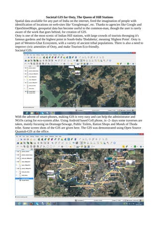
With the advent of smart-phones, making GIS is very easy and can help the administrator and
NGOs caring for eco-system alike. Using Android based Cell phone, in -2- days some traverses are
taken, mainly focusing on Drainage/Sewage, Public Toilets, Ration Shops and Munds of Thoda
tribe. Some screen shots of the GIS are given here. The GIS was demonstrated using Open Source
Quantub-GIS at the office.
2. The field work was done from 15th
May 2014 to 16th
May 2014, by self, and Ajay, Rajahmundry
project researcher.
Software/Hardware for data collection: Samsung Android mobile with 'OsmAnd', and
'GpsEssentials' software which are 'free'.
Software for GIS: Open Source Qgis.
A demonstration of Societal GIS was done on 17-5-2014 C.P.R Environmental educational centre,
Side of Ponmari Hotel, 26-B Kothagiri rd, Ooty 643002. Mr Komaravelu and invited societal
activists were present.
V.Ravi Kumar
Secretary, OSGeo India
IIIT, Hyderabad