History Class XII Ch. 3 Kinship, Caste and Class (1).pptx
Earth
1. http://astrogeology.usgs.gov
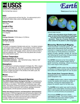
Earth
Third planet from the Sun
Orbit
Earth is 1 astronomical unit from the Sun. An astronomical unit is
92,955,807 million miles, which is 499 light seconds
Orbital Period
365.2 days
Length of Day
24 hours, or 1 day
Tilt of Rotation Axis
23.5 degrees NASA/JPL/NIMA PIA03394
Earth is the only planet whose English name
Size does not derive from Greek/Roman mythology.
Average Diameter: 7,918 miles or 12,740 km The name derives from old English and
Germanic. There are, of course, hundreds of
Surface Gravity other names for the planet in other languages.
32.1 ft/s2 or 9.8 m/s2
Structure Measuring, Monitoring & Mapping
The Earth is composed of silicate rocks and iron. Its interior contains There have been numerous space-, air-, and
a core largely made of molten iron, surrounded by a thick mantle of water-borne instruments that have been
partly molten rock (oxygen, silicon, magnesium and iron) , covered by
important in mapping the Earth and learning
a very thin surface crust (oxygen, silicon, aluminum and iron) that is
solid and relatively cool. The Earth is the only planet with a known more about our home planet as a dynamic
active plate tectonic system. system of water, geology, climate, air, and life.
The following list is just a few of these remote
Surface Temperature sensing instruments and platforms:
Mean temperature: 59° Fahrenheit
Temperature extremes: 136° Fahrenheit (Libya, 1922) to -128° The ASTER instrument on the Terra satellite is
Fahrenheit (Vostok Base, 1983) being used to obtain detailed images used for
glacier monitoring, climatology, volcano monitoring,
Atmosphere and a wide range of other purposes.
The atmosphere is primarily composed of nitrogen (N2, 78%), xxygen
(O2, 21%), and argon (Ar, 1%). Earth’s substantial atmosphere has The LANDSAT satellite system has been gathering
weather patterns primarily driven by heat from the Sun. On Earth, a collection of imagery covering most of the Earth’s
however, another key factor in the climate is the water cycle, the land surface and coastal regions for over 30 years.
continual cycling of water.
Space Shuttle Radar Topography Mission
Moons completed Earth’s most extensive and detailed
Number of Moons: 1 global topographic map.
Core U.S. Government Research Agencies The GOES satellite system collects images used to
The USGS (United States Geological Survey) was established by monitor the weather and climate by a variety of
Congress in 1879 to provide geologic, topographic, and hydrologic scientists, including the meteorologists who
information to the Nation. This information comprises maps, data prepare the weather report for the daily news.
bases, and reports containing analyses and interpretations of water,
energy and mineral resources, land surfaces, geologic structures, The GLORIA sonar system was used to map the
natural hazards, and the dynamic process of the Earth. seafloor in the United States’ Exclusive Economic
Zone, a 200 nautical mile zone around the coasts
NOAA (the National Oceanic and Atmospheric Administration) of the U.S. and its territories and possessions.
was formed in 1970 from agencies that are among the oldest in the
Federal government. NOAA has as its mission to understand and The air-borne AVIRIS instrument collects
predict changes in the Earth’s environment and conserve and hyperspectral images. The primary research done
manage coastal and marine resources to meet our Nation’s with AVIRIS data have been related to global
economic, social, and environmental needs. environment and climate change.
9/20/2005