SlideShare a Scribd company logo
1 of 44
Download to read offline
1
2
3
4
5
6
7
8
9
10
11
12
13
14
15
16
17
ft.
ft.
0
Pre-Sandy Base Flood Elevation
Sea level datum NAVD 88
Projected Year 2080 Flood Height with Sea Level Rise
Projected Year 2050 Flood Height with Sea Level Rise
Post-Sandy Advisory Base Flood Elevation
with Residential Freeboard
2012 Sandy Surge Level
Post-Sandy Advisory Base Flood Elevation
INITIATIVE
POST
SANDY
Nominal Ground Level
Building Better,
Building Smarter:
Opportunities
for Design
and Development
May 2013
8'10.8"
0'
16'7"
14'5"
14'
13'
12'
8'
16'7" Projected Year 2080 Flood Height
with Sea Level Rise
14'5" Projected Year 2050 Flood Height
with Sea Level Rise
“Climate Change Adaptation in New York City:
Building a Risk Management Response:
New York City Panel on Climate Change 2010,”
Annals of the New York Academy of Sciences
Volume 1196, 41-62. New York, May 2010.
14' Post-Sandy Advisory Base Flood
Elevation with Residential Freeboard
Mayor Bloomberg Announces New Measures
to Allow Home and Property Owners Rebuild-
ing after Hurricane Sandy to Meet Updated
Flood Standards, January 31 2013
http://www.nyc.gov/portal/site/nycgov/
menuitem.c0935b9a57bb4ef3daf2f1c-
701c789a0/index.jsp?pageID=mayor_press_
release&catID=1194&doc_name=
http%3A%2F%2Fwww.nyc.gov%2Fhtml%
2Fom%2Fhtml%2F2013a%2Fpr044-13.html
&cc=unused1978&rc=1194&ndi=1
13' 2012 Sandy Surge Level
“NYC Storm Surge Map,” Center for the
Advanced Research of Spatial Information,
Hunter College, City University of New
York, 2012. http://www.carsilab.org/sandy
12' Post-Sandy Advisory Base Flood Elevation
(see source for 14')
8'10.8" Pre-Sandy Base Flood Elevation
Federal Emergency Management Agency.
“Advisory Base Flood Elevation Information,
Region 2 Coastal Analysis and Mapping.”
2013. http://www.region2coastal.com/sandy/
table
8' Nominal Ground Level
Federal Emergency Management Agency.
Ground level at example site (111 Beach 222nd
Street, Breezy Point, Queens), “Advisory Base
Flood Elevation Information, Region 2 Coastal
Analysis and Mapping.” 2013.
http://www.region2coastal.com/sandy/table
0' Sea level datum NAVD 88
Wikipedia. “North American Vertical Datum
of 1988,” last modified April 10, 2013.
http://en.wikipedia.org/wiki/North_Ameri-
can_Vertical_Datum of_1988
Cover Image credit: NASA/NOAA
1
2
3
4
5
6
7
8
9
10
11
12
13
14
15
16
17
ft.
ft.
0
Pre-Sandy Base Flood Elevation
Nominal Ground Level
Sea level datum NAVD 88
Projected Year 2080 Flood Height with Sea Level Rise
Projected Year 2050 Flood Height with Sea Level Rise
Post-Sandy Advisory Base Flood Elevation
with Residential Freeboard
2012 Sandy Surge Level
Post-Sandy Advisory Base Flood Elevation
POST
SANDY
Building Better,
Building Smarter:
Opportunities
for Design
and Development
May 2013
INITIATIVE
8'10.8"
0'
16'7"
14'5"
14'
13'
12'
8'
In response to Superstorm Sandy, the
American Institute of Architects New York
(AIANY) has spearheaded a collaborative
initiative investigating issues and outlining
options and opportunities to address the
short-, intermediate-, and long-term
impacts of the storm and the escalating
effects of climate change on New York
City. The impetus for this work grew in part
from an informal partnership that had
developed between the AIANY Design for
Risk and Reconstruction Committee (DfRR)
and the NYC Department of City Planning
(DCP). Starting well in advance of Hurri-
cane Sandy, these two groups had collabo-
rated on multidisciplinary design explora-
tions related to climate change. In addition,
the DfRR Committee and AIANY undertook
a number of other pre- and post-Sandy
initiatives, including training and organiza-
tion of FEMA neighborhood assessment
programs and coordination of initiatives
with the NYC Office of Emergency Man-
agement (OEM), the Dean’s Roundtable,
related area design schools, and relevant
AIA National programs. After the devasta-
tion of the storm, this relationship expand-
ed to include a larger set of collaborators,
the Post-Sandy Initiative, which prepared
this summary.
This Initiative includes relevant committee
members from AIANY and volunteer
representatives from other AIA chapters
and sister organizations who share the
commitment to recovery and belief that
planning and design are a crucial compo-
nent of rational decision-making. Numer-
ous other agencies, panels, and organiza-
tions have been working in parallel with
this Initiative, including those convened by
the Mayor’s Office, the City Council, the
Governor’s Office, the Municipal Art
Society, the Regional Plan Association,
Pratt Institute, and many others. We intend
our work to complement and support these
efforts, especially those with ties to the
most affected populations.
The Initiative has four
overarching objectives:
First, to prepare a multifaceted report
illuminating options and opportunities
based on the best information available
in a short amount of time. The report is
intended to provide policymakers with
additional tools as we forge ahead in
response to Sandy.
Second, to mount an exhibition of this
open-ended information so that it can be
shared, discussed, and debated by design
professionals, stakeholders, and recovery
leaders.
Third, to initiate public symposia
and ongoing programs in the four
areas covered in the report, providing
a framework for continued focus on
Sandy recovery.
Fourth, to undertake continuing advocacy
with relevant public, private, and institu-
tional stakeholders, expanding the re-
sponse to Sandy into efforts for a more
resilient future.
In the wake of Sandy, it is evident that we
need to learn from other cities and regions
that have suffered similar weather events.
These precedents serve as best practices
on which we can rely as we begin to build
back better and smarter. We support
research into resilient measures of
building, which can secure our regional
future and become, in turn, best practices
that can be helpful to other areas at risk.
As delineated in the following pages,
participants have defined a variety of
short-, medium-, and long-term responses
in four key areas—Transportation &
Infrastructure, Housing, Critical & Com-
mercial Buildings, and Waterfront—that
will feed into these larger public, private,
and institutional efforts. Following the
release of this report, we will continue
these fruitful collaborations and advocate
for ensuring the health, safety, wellbeing,
and quality of life of our magnificent city
and region. Building Better. Building
Smarter.
Preface
Collaborating Organizations:
American Council of Engineering
Companies (ACEC New York)
American Society of Landscape
Architects New York Chapter
(ASLA-NY)
Citizens Housing & Planning Council
(CHPC)
New York State Association
for Affordable Housing (NYSAFAH)
American Planning Association New
York Metro Chapter (APA-NYM)
Regional Plan Association (RPA)
Structural Engineers Association
of New York (SEAoNY)
For more information on AIANY’s
Design for Risk and Reconstruction
Committee (DfRR) please refer to
www.designforrisk.com
4
Post-Sandy Initiative
Executive Summary
INTRODUCTION
TRANSPORTATION
& INFRASTRUCTURE
HOUSING
CRITICAL
& COMMERCIAL
BUILDINGS
WATERFRONT
ADAPTATION,
ADVOCACY
& NEXT STEPS
List of Volunteers
12
8
6
43
18
26
32
40
5
Table of Contents
Superstorm Sandy revealed that we have
created a defenseless built environment:
1. Land-use patterns encourage fragile
dwelling units and critical facilities in
the most vulnerable locations.
2. Transportation and utility systems fail
in the face of extreme weather events.
3. Stormwater management and develop-
ment policies now in effect actually
increase the impact of runoff.
4. Existing buildings are barriers to
sustainability, squandering power
and producing greenhouse gases.
The overarching long-term objective is
resilience, which can best be achieved by
modifying buildings, transportation and
infrastructure networks, and land-use
patterns.
XX This will require consensus on stan-
dards and where they apply—what
constitutes “harm’s way,” based on
updated predictions of flood zones,
storm surges, and sea-level rise, and
how these assumptions may shift or
increase in coming years.
XX It will also take careful analysis of many
possible strategies—examining relative
costs and benefits in the context of likely
useful lifespans.
XX There is no universal solution. Design
approaches should be site-specific and
respond to local programmatic needs.
A great deal of work has been published
and is underway on responding immedi-
ately after disasters. As architects,
planners, and designers, our focus has
been, instead, in an area where we can
make the most meaningful contribution:
design approaches to new construction
and rehabilitation to help limit the effects
of future storms on our built environment,
and processes to help us coordinate our
efforts to provide critical services, includ-
ing regional transportation, immediately
after a major storm.
Building back better and smarter—moder-
ating past mistakes through careful
planning, becoming more energy indepen-
dent, and requiring sustainable design and
construction practices—will help reverse
the vulnerability we have inherited from
centuries of misguided development.
before the fact and regional coordina-
tion during extreme events, including
emergency wayfinding strategies to
inform residents about alternative
backup plans for transportation, power,
fuel, and locations for assistance.
XX Recognize that infrastructure failures in
New York City can have catastrophic
international impacts. The funding
required to strengthen our infrastructure
should be leveraged through all parties
that benefit from preventing expanding
economic disorder.
HOUSING
Multi-family buildings fared much better
than one- and two-family dwellings. Yet
local and national regulations related to
housing in flood zones do not address the
conditions of a dense urban place like New
York City.
Superstorm Sandy revealed the need for
new strategies to address evacuating
residents who will be displaced in future
disasters, and their security and comfort if
sheltering in place is necessary. The
existing housing stock must be retrofitted
to become more resilient. Standards for
new housing must ensure that it can be
safe, accessible, and attractive.
Key concepts and findings
Housing displaced people in extreme
events requires knowledge of available
units, a centralized intake process, and a
set of tools including appropriate waivers,
qualifying processes, model lease agree-
ments, and allocation of subsidies.
Non-profit housing providers need support
with post-disaster training to address
residents’ needs, especially in flood-prone
neighborhoods.
Gaps in current floodproofing guidelines
and regulations—at both local and federal
levels—must take into account the charac-
ter of dense urban environments.
Multi-unit housing stock in flood zones,
even where damaged, remains largely
sound. With strategic modifications, the
useful life of most of these buildings can
be extended well into the future.
Broader planning implications should be
addressed, such as whether exceptions to
allow multi-family housing in downzoned
coastal areas could increase community
resiliency.
Opportunities and next steps
FEMA and National Flood Insurance
Program literature is largely focused on
one- and two-family housing. It is our
conclusion that a FEMA multi-family
design guide is very much needed.
Executive
Summary
TRANSPORTATION
 INFRASTRUCTURE
Regional coordination and planning for
redundancy can ensure that our transpor-
tation and infrastructure networks will
operate before, during, and after severe
weather events.
These aging systems were not built to
withstand today’s rising sea levels and
severe storms. Identifying their vulnerabili-
ties and planning for their reinforcement is
an urgent priority, demanding interagency
collaboration, public education and
commitment, and solutions that contribute
to the design quality of the City and region.
Key concepts and findings
Planning for Redundancy: Transportation
and infrastructure networks are interde-
pendent. Multiple and alternative power
sources can keep them functioning during
severe weather events. Robust, multiple-
system communication plans can alert the
public to evolving conditions.
Planning for Resiliency: Reinforcing
vulnerable structures and repositioning
critical equipment can protect vital
infrastructure systems. Sensitively-de-
signed elements can also serve as urban
amenities. Replacement of those systems
that were heavily damaged by Superstorm
Sandy should maximize long-term sustain-
ability.
Planning Smart: We have identified case
studies that reveal three distinct strategic
approaches—defensive, adaptive, and
passive. Defensive infrastructure can
demand burdensome long-term funding
and management; for each particular
situation, scenario-planning exercises and
other research are needed to suggest
whether hard infrastructure (with a
constructed resiliency) or simpler, softer
solutions will best protect the community.
Adaptive efforts reduce disruption of
natural ecosystems, and focus on green
infrastructure approaches. Passive
solutions accept that protecting invest-
ments is impractical in a particular
situation, and focus on moving or provid-
ing alternative systems. For all strategies,
solutions must contribute to the ameliora-
tion of service gaps and improved design
quality of the public realm.
Opportunities and next steps
XX Assess the infrastructure and transpor-
tation systems at greatest risk, and
identify strategies for their redundancy
and resiliency.
XX Educate the public about challenges
ahead to ensure realistic expectations
and support for required expenditures.
XX Improve interagency and interstate
communications for holistic planning
6
Post-Sandy Initiative
Zoning regulations should be adjusted, in
light of predicted higher flood levels, to
recognize the amount of space needed by
required ramps, elevators, and lifts in
multi-family buildings, and to provide for
the relaxation of height restrictions in
order to accommodate higher-elevation
ground floors.
In low-income rental buildings and
supportive and senior housing, where
residents may not be able to individually
evacuate, safe rooms and expanded
programs should be provided to allow
congregation, roll call, and rescue during
emergency conditions.
Multi-family housing should be engineered
with building systems that protect against
HVAC shutdowns, provide for alternative
power during outages, and ensure a quick
return to normal.
CRITICAL  COMMERCIAL BUILDINGS
The challenges of adapting the vast
inventory of existing critical buildings to
withstand the effects of extreme climate
events are distinct from the relatively
easier task of designing new structures for
resiliency.
Critical facilities like hospitals, police
stations, and data centers must be able to
withstand the effects of a disaster and
remain in operation without evacuation.
Other buildings in vulnerable locations
may be evacuated, but should be designed
to survive without structural failure.
Building owners have a responsibility to
protect occupants, protect structures and
contents from damage, and ensure that
buildings can operate during and after the
event.
Key concepts and findings
Owners of all commercial and institutional
buildings—existing, in construction, or
planned—should begin now to:
XX Conduct vulnerability assessments of
their buildings in anticipation of the
likely effects of extreme climate events.
XX Identify technical standards and tech-
nologies that will allow their buildings to
successfully withstand these events.
XX Update plans to keep buildings opera-
tional during disasters and to quickly
recover functionality afterwards.
XX Create implementation plans to put in
place remedial actions indicated by the
three preceding steps.
Opportunities and next steps
Disaster-resistant building design strate-
gies, technologies, and materials that
already exist or are being developed
elsewhere should be examined and
adapted here.
We should move toward replacing existing
critical buildings in harm’s way that cannot
be hardened, with exceptions for buildings
of historic or cultural significance.
We need regional protective systems that
can enhance, or eliminate the need for,
individual building responses.
The challenges that hurricane conditions
and floods pose for buildings, in particular
those in densely populated areas, should
be brought to the attention of the many
scientific, governmental, and professional
organizations currently exploring the
potential impacts of climate change.
Dialogue will lead to better simulation
models of water and wind behavior on
built structures, a new national reference
code for building construction, and zoning
and planning approaches that bring
patterns of development into line with
present and emerging knowledge about
disaster-prone areas.
WATERFRONT
The future of New York as a waterfront city
depends on respecting our changing
environment and building on the unifying
strength of our dynamic harbor and
waterways in creative ways.
Superstorm Sandy has given us a new
perspective on New York City’s diverse
waterfront and watershed—comprising
ocean, riverine, and estuarine systems
within a broader context of interactive
water flow. Floods and storm surges are
part of natural cycles, although their
frequency, intensity, and impact on our city
are increasing. Within this ecological
context, an array of opportunities exists
that can integrate diverse land-uses—pub-
lic access, parks, housing, commercial
districts, and working waterfronts—and
accommodate the climatic events we must
now anticipate.
Key concepts and findings
More scientific research will help us to
understand the interactions between
urban waterfront and human ecologies.
We need a dynamic and innovative
approach to waterfront projects, allowing
for experimentation and novel resiliency
strategies.
Interdisciplinary collaborations, organiza-
tional structures, and funding mechanisms
could promote robust collaborations
among pure and applied disciplines—link-
ing the design community, the scientific
research community, and the regulatory
community.
There is always more than one solution.
New York City has 520 miles of shoreline,
with varying geomorphology, hydrology,
land-uses, and habitat types. Planning and
design of waterfronts should embrace
unique, site-specific attributes.
For instance, we need to set priorities for
current and future funding for the alterna-
tives being identified and discussed by the
City’s post-Sandy task force, the Special
Initiative for Rebuilding and Resiliency
(SIRR).
There is always more than one solution.
New York City has 520 miles of shoreline,
with varying geomorphology, hydrology,
land-uses, and habitat types. Planning and
design of waterfronts should embrace
unique, site-specific attributes. For
instance, we need to set priorities for
current and future funding for the alterna-
tives being identified and discussed by the
City’s post-Sandy task force, the Special
Initiative for Rebuilding and Resiliency
(SIRR), the Department of City Planning’s
year-long Urban Waterfront Adaptive
Strategies Study, and NYS 2100 Commis-
sion. These include nourishing beaches
and expanding dunes, reinserting wet-
lands, raising bulkheads, adding tide gates
and revetments, building breakwaters,
installing passive and deployable flood-
walls, constructing seawalls and surge
barriers, and conceiving of dual-use or
multi-purpose levees.
Redundancy and modularity should be
built into flood protection and stormwater
management systems in densely-populat-
ed areas.
All members of waterfront communities
should be included in the planning and
implementation processes via community
outreach and communication.
Opportunities and next steps
We need a ground-up, incremental
approach to waterfront resiliency, partner-
ing with local communities to generate
sensitively formulated solutions, and
arming property owners with a menu of
strategies. From government we need
agility and flexibility in regulations, and
funding that affects the planning and
design of waterfront solutions in the
context of a collaborative, problem-solving
approach.
We propose Waterfront Labs to investigate
strategies that could mitigate storm surge,
prevent erosion, and soften the impact of
rising tides. Experiments would focus on
both predictable and unpredictable events,
and take into account the different natural
typologies found in the New York City
region. The Waterfront Lab will make an
important contribution by bringing New
York City to the forefront of innovative
waterfront resiliency planning and design.
7
Executive Summary
The cover of this report graphically
quantifies Sandy’s impact—and future
potential implications—in terms of
comparative feet and inches. Sandy’s
regional inundation levels are shown
in the adjacent map.
As we now understand, many of the
most acute impacts of Superstorm
Sandy resulted from the confluence of
several unique circumstances: an
off-shore hurricane that entered the
New Jersey / New York City / Long
Island region at full bore; a fast-rising
storm surge that came and went quickly;
one of the highest tides of the year
combined with a full moon; a
Nor’Easter, and a disturbance in the jet
stream that caused the storm’s turn
west into New Jersey. We need to learn
from Sandy in order to address other
different but equally threatening factors
that may emerge from the next storms.
For example, Hurricane Irene in 2011
caused flooding resulting from intense
rainfall, rather than the storm-surge-
driven flooding seen during Sandy.
Wind damage from Sandy was limited
to the area of first landfall, although tree
damage and resulting power outages
were major issues in adjacent inland
areas. Obviously it is difficult to predict
the factors and results associated with
any storm.
Superstorm Sandy resulted in large
numbers of people losing their homes,
livelihoods, and in some instances, their
INTRODUCTION
lives. More than 10% of the City’s
population (almost 850,000 people)
lived in Sandy’s Inundation Zone—
over 325,000 dwelling units in 78,000
buildings (85% of which were built
before 1983 flood-related building code
upgrades, and over 60% of which
suffered FEMA-inspected damage).
The New York City Police and Fire
Departments rescued more than 1,700
people, with likely many more unre-
ported. While the vast majority in the
region did not suffer to the degree as
those in that zone, what did affect
everyone unilaterally was the damage
to our citywide systems: transporta-
tion and utilities, housing, critical and
commercial buildings, and the water-
front. The energy infrastructure was
damaged along the regional supply
chain of fuel terminals, pipelines, and
gas stations. Hundreds of thousands
were without power—approximately
80,000 residents in more than 400 New
York City Housing Authority (NYCHA)
buildings were affected by loss of
electricity, heat, or hot water. The
storm revealed vulnerabilities across
the Tri-State Area and focused atten-
tion on the question of long-term
viability. Since October 2012, numer-
ous initiatives are under way at local,
regional, and federal levels to deter-
mine how to respond to future impacts
from such storms, which are antici-
pated to happen with even greater
frequency and intensity.
8
Post-Sandy Initiative
Superstorm Sandy
Surge Infiltration MapSource: MOTF Inundation Model Date: April 3, 2013
© 2013 ESRI, DeLorme, NAVTEQ
9
Sandy’s unexpected power and breadth
created a need for realistic standards to
protect communities in the way of future
storms—which may be even more
powerful in terms of wind, rain, and
potential damage. This unprecedented
challenge, complicated by estimates of
rising sea levels and increasing frequen-
cy of events, will define how we plan and
regenerate the inundated areas and the
regional context.
Even as people and buildings suffered
terrible direct impacts, the City and
region as a whole suffered massive
indirect impacts of the storm. Adverse
effects to economic vitality, communica-
tions infrastructure, and connectivity
networks were widespread.
The initial step in any disaster is
response, preserving life and critical
property in the midst and immediate
aftermath of the event (ideally preceded
by effective pre-planning for evacuation
and staging of needed resources). This
is followed by recovery, returning to as
much normalcy as possible, in turn
followed by organized and deliberate
rebuilding. The overarching long-term
objective is resilience—modifying
buildings and land-use patterns over
time, and infrastructure where significant
investment prevents physical relocation,
and waterfront edges that transition
between the shore and upland areas—
hardening and/or softening as relevant
to mitigate the impact of future events.
In order to deal with these challenges,
Mayor Michael Bloomberg’s Special
Initiative for Rebuilding and Resiliency
(SIRR) program is engaged in preparing
an integrated strategy to address how
we rebuild New York City to be more
resilient in the wake of Hurricane Sandy,
but with a long-term focus. The City will
use its first allocation of federal Commu-
nity Development Block Grant (CDBG)
funds to support recovery from Sandy
and to build in resilience to the challeng-
es of climate change, including programs
to build and support housing, businesses,
infrastructure, and other city services.
This process, undertaken through the
coordination of numerous governmental
agencies and multidisciplinary advisors,
relies heavily on community outreach to
define issues and priorities. As planning
and design professionals, our intent is to
support that process through our parallel
volunteer efforts.
But as we step back from the immediate
shock and imperative response to
emergency conditions, we must recog-
nize that much of the problem lies in our
own culpability as a client society—the
way we have helped over the years to
create a susceptible built environment:
XX Land-use patterns that encourage
fragile dwelling units and critical
facilities in the most vulnerable loca-
tions;
XX Transportation and utility systems that
fail more and more frequently in the
face of natural events;
XX Stormwater management and develop-
ment policies that increase rather than
decrease the impact of runoff;
XX Existing buildings that are barriers to
sustainability—and that, in NYC, use
94% of electrical production and
produce 75% of greenhouse gas
emissions.
Overall, sea levels are rising and extreme
storm events are becoming more
frequent, both because of natural cycles
and the worsening impact of human-
induced climate change. By building back
better and smarter—moderating our past
poor decisions through careful planning,
becoming more energy-independent,
and setting in motion new, sustainable
design and construction practices—we
can begin to mitigate or reverse the
effects of centuries of misguided devel-
opment policies.
The Post-Sandy Initiative
The Post-Sandy Initiative, the collabora-
tion that produced this summary report,
is structured as the planning and design
community’s response to this challenge.
Initiated by the American Institute of
Architects New York (AIANY) in the
weeks that followed the storm and in
collaboration with a wide range of other
professional organizations and con-
cerned individuals, it has been supported
by the participation of a variety of local,
regional, state, and national public
agency participants. At publication time,
still only months after Sandy swept
through our region, this report is a slice
in time of our efforts as of April 2013—
a definition of issues, an analysis of
options and opportunities, and the
establishment of a framework for next
steps. As our community continues to
explore these issues and develop ideas
for building better and building smarter,
progress reports will be issued online at
www.postsandyinitiative.org
Unlike many of the areas devastated by
comparable American storms, New York
City is a major urban region whose
vitality and resiliency depends on a
complex web of interconnected systems.
With more than 8 million residents,
6 million commuters each day, and 50
million annual visitors, New York City is
the largest regional economy in the
United States, and the second largest
city economy in the world after Tokyo.
New York is a cultural capital and home
to hundreds of museums, performing
arts venues, and historic sites; and more
than 600,000 students are enrolled at the
City’s 110 higher education institutions, a
larger number than the entire population
of Boston.
Through the Post-Sandy Initiative’s
working groups, it quickly became clear
that “one size does not fit all”—the
imposition of national or other stan-
dards, often based on rural, suburban,
or small-city situations, may not always
be applicable to our high-density envi-
ronment, and falls short in addressing
our complex, interconnected social and
economic culture. A series of comple-
mentary initiatives, many based on
experience from outside the United
States, is required to affect meaningful
change.
As part of this Initiative, many profes-
sionals have given their time to explore
important issues about Sandy and the
response to date, both in terms of
shorter-term recovery efforts and
longer-term resiliency considerations.
It is clear that we can, and need to, do
better in the face of future extreme
weather events. Key areas for further
discussion include:
During a major storm event:
XX Dealing with governmental/OEM and
FEMA evacuation mandates in the face
of concerns such as public housing
10
Introduction
Post-Sandy Initiative
constraints, property owner reluctance,
and public safety considerations;
XX Ensure that evacuees have places to go
out of harm’s way, and reliable means
to get there;
XX Reinforce and protecting building
systems, infrastructure function, and
ability to provide police and fire
protection.
Short-term recovery:
XX Assess the damage to property and
community;
XX Provide equitable public support in the
face of varying insurance coverage;
XX Justify and balance rapid-recovery
efforts and costs with follow-up
repairs;
XX Define the standards for remediation,
and resulting costs, in terms of
medium-and long-term benefits;
XX Understand the implications of insur-
ance rates based on those standards,
and their impact on property owners of
various incomes.
Medium-term remediation:
XX Define workable standards for both
relatively easier new construction and
significantly more difficult existing
repair and reconstruction;
XX Develop approaches for rebuilding
based on sustainability and resource
conservation;
XX Establish clear standards from amongst
differing expectations on the rate of
climate change and sea-level rise
predictions;
XX Deal with social inequity, community,
and economic issues of long-term
settlement in areas that are now in
harm’s way;
XX Create equitable (and appropriately
funded) programs for purchase of
destroyed or damaged homes and
transference into open space.
Long-term resilience:
XX Analyze long-term infrastructure and
waterfront investments despite a lack
of definitive new scientific standards
for flood zones and sea-level rise;
XX Evaluate how to finance premiums for
design and construction based on
short-term cost but long-term benefit
without affecting immediate alternative
needs or choices;
XX Advocate planning and design solu-
tions that reduce carbon emissions
and our reliance on fossil fuels, as well
as work with anticipated future water
levels.
There are two major determining
factors in defining resilience:
XX Achieve consensus among the respon-
sible parties (FEMA, the states, the City,
and other municipalities, insurance
companies) as to standards— what
constitutes “harm’s way.” This defini-
tion will necessarily be based on
predictions of sea-level rise, possible
storm surges, and recommended
allowances for “freeboard” above
those flood levels—and how they are
predicted to increase over a series of
benchmarks throughout the coming
century and beyond.
XX Careful cost-benefit analyses that
take into account funding cycles and
the benefits of funds at the users’ end,
present value, and alternative uses
of funds.
As the planning and design community,
we are one voice in these critical issues.
But our expertise and perspective are
invaluable components of the solution.
Architects, landscape architects, plan-
ners, and engineers must be at the table
as policies and standards are developed
to mitigate or reduce the risk of cata-
strophic damage from the next storm.
We must apply our experience to those
issues that speak to the physical, social,
and environmental implications of
possible decisions. More value and
emphasis must be placed on long-range
comprehensive planning under the
initiative of elected leaders. Systems and
resources must be organized so that
short-term decisions are aligned with
long-term health, safety, and sound
investment.
We framed this Post-Sandy Initiative in
terms of design implications and applied
design thinking. A set of working groups
examined key aspects of the built
environment in detail, through collabora-
tion, research, workshops, and design
charrettes. We have examined these
topics in terms of short-, medium-, and
long-term time frames, and at a range of
scales, from individual buildings to
neighborhood contexts, the surrounding
city, and the region as a whole.
The following chapters summarize
issues, options, and opportunities
identified by four of these working
groups—Transportation  Infrastructure,
Housing, Critical  Commercial
Buildings, and Waterfront. The valuable
work of a fifth working group—Zoning
 Codes—has been incorporated
throughout the text. Each of these
reports is supplemented online by
additional material delving into specific
areas of concern and concepts for
building better and building smarter at
www.postsandyinitiative.org
The overarching long-
term objective is
resilience—modifying
buildings and land-
use patterns over time,
infrastructure where
significant investment
prevents physical
relocation, and waterfront
edges that transition
between the shore and
upland areas —
hardening and/or
softening as relevant to
mitigate the impact of
future events.
11
Introduction
Public transportation entities such as the Metropolitan
Transportation Authority (MTA), NJ TRANSIT, the Port
Authority of New York  New Jersey (PANYNJ), and Amtrak
are all re-examining Sandy’s impacts and developing short-
and long-term responses to climate change within the
context of restricted budgets and smaller workforces.
City agencies responsible for infrastructure—sewer, water,
and stormwater drainage—are examining failures and
planning for future needs. Power utility providers such as
ConEdison, LIPA, and PSEG are developing new strategies.
Advocacy groups such as the Municipal Art Society (MAS),
the Regional Plan Association (RPA), and the Rudin Center for
Transportation have served in multiple roles, from educating
the public through public dialogues and white papers, to
lobbying for funding and improved communication among
infrastructure and transportation providers. It is critical to
understand all of these ongoing efforts while working across
disciplines that cross municipal and state lines.
Interagency collaboration and a well-developed communica-
tions plan established jointly by various transportation and
infrastructure agencies that serve the City and region can
strengthen the framework for future multi-modal redundancy
and resiliency.
Regional coordination and planning
for redundancy can ensure that our
transportation and infrastructure
networks will operate before, during,
and after severe weather events.
TRANSPORTATION
 INFRASTRUCTURE
12
Post-Sandy Initiative
KEY CONCEPTS
AND FINDINGS
As noted in Governor Andrew Cuomo’s
NYS 2100 Commission report, “Recom-
mendations to Improve the Strength and
Resilience of the Empire State’s Infra-
structure” (November 2012), New York
State’s recent ClimAID projections show
that higher temperatures and sea-level
rise are extremely likely for New York
State through the end of the century,
and that by 2100, experts project sea
levels to rise in New York City and Long
Island by as much as six feet under
certain scenarios. Given our aging
transportation and infrastructure, those
statistics make identifying the weak-
nesses in our systems of utmost urgen-
cy. The following strategies are our
recommendations for responding to the
new anticipated norm.
Planning for Redundancy
Planned redundancy provides a more
flexible infrastructure. As many of our
transportation and infrastructure
networks are interdependent, losing
one often causes the loss of others.
Working towards providing appropriate
backup power systems along with
alternative power sources, such as solar,
wind, or geothermal, will make grid
dependency less critical. Policies that
encourage redundancy would promote
these actions.
Developing a robust communications
network and plan will allow transporta-
tion agencies to alert the public about
station closings and alternate transpor-
tation routes, prior to and immediately
after severe storm events.
Planning for Resiliency
There are currently available physical
solutions that can protect our transpor-
tation and infrastructure networks
against flooding. Sensitively designed,
these barriers can also serve as urban
amenities. By reinforcing vulnerable
structures, we can fortify them to
withstand these “new normal” events.
These actions should be supported by
policies that address strengthening
existing structures with ongoing repair
programs, as detailed in Section 3 on
critical and commercial buildings.
Placing new electrical equipment above
anticipated flood levels and replacing
damaged equipment with new equip-
ment designed to work in a harsh
salt-water environment are examples of
strategies that could be implemented as
part of an overall plan.
As we move from short-term recovery to
long-term planning for redundancy and
resiliency, we need to plan smart so we
can build smart.
Planning Smart
Smart planning in the new ecosystem
involves looking at transportation and
infrastructure systems in new ways. It
begins with an intermodal interagency
process of regional cooperation, commu-
nication, and coordination for standard
operations, regular outages, and extreme
weather situations.
Once in operation, New York City’s CitiBike program will provide alternative
transportation for some residents. Photo credit: CitiBike / NYC Bikeshare
Temporary flood barriers were constructed
prior to the storm at vulnerable entrances.
Photo credit: Flickr / MTA Photos Photostream
13
Options and Opportunities: Transporation  Infrastructure
It includes recognizing the efficiency of
having tunnels act as drains for our
cities, and considering the different ways
that systems can function during severe
storms, and how that differs from how
they perform during a non-event.
Providing uninterrupted services at vital
facilities such as hospitals, firehouses,
and shelters should be prioritized as
part of an overall infrastructure network.
Planning smart means examining
existing and new infrastructure compre-
hensively with a clear understanding of
specific risks that vary based on loca-
tion. Building better will mean coordi-
nating systems between agencies
serving the same region, and acknowl-
edging that often a replacement in-kind
is not an adequate solution.
To plan smart, we need to enhance our
guidelines and standards for resiliency
and redundancy by integrating the
following best practices:
New Infrastructure
The Inner Harbor Navigation Canal
Surge Barrier in New Orleans (the only
one like it to date in the United States),
London’s Thames Barrier, and the Delta
Works in the Netherlands are examples
of climate change-responsive infrastruc-
ture solutions that are less than 30 years
old. These structures typically need to
be funded from design through con-
struction and maintenance. As an
example, sewage treatment failures in
extreme storm events may require
long-term funding of a hardened system
to mitigate such problems in future
storms. We recognize that in our region,
these new types of infrastructure will
need to be developed and maintained by
a new public institution, or added to the
responsibilities of an existing one.
Scenario-planning exercises in different
communities, similar to what is being
demonstrated as part of Mayor Bloom-
berg’s citywide Special Initiative for
Rebuilding and Resiliency (SIRR), can
further inform how soft solutions or hard
infrastructure can protect communities
from severe storms like Sandy, and how
they may either detract from or enhance
those communities’ quality of life.
Reduce Impact to the Ecosystems
New York City already has one of the
lowest carbon footprints per capita in
the country. As we develop these
recommendations, we must continue to
reduce this footprint and reinforce our
city’s approach to sustainability, ensur-
ing that our redundancy recommenda-
tions reduce negative environmental
impacts as well. The use of permeable
paving materials and water retention
systems that reduce the demands on
sewer systems are two such viable
possibilities. Another is to encourage
less energy-dependent transportation
modes, such as bicycle and pedestrian
networks and technologies, as part of
the overall regional transportation
system.
It will also be important to look at areas
and communities that may have been
underserved in terms of a broader
adoption of green infrastructure mea-
sures, and how that, in fact, may mini-
mize flooding in the future.
G-Cans Project,
Tokyo, Japan
One of the world’s
largest underground
flood-water diversion
facilities was designed
to protect Toyko
from flooding during
typhoon season and
heavy rains.
14
Options and Opportunities: Transporation  Infrastructure
Post-Sandy Initiative
Urban Design Quality
Part of building for a resilient future is
protecting our communities from
problems resulting from climate change,
and doing so in a way that uses natural
as well as engineered measures to
improve both redundancy and resiliency.
Neither measure should, however,
exclude maintaining the quality of the
built and natural environment. There-
fore, it is critical to solve these technical
challenges in a way that does not lose
sight of the human condition. Solutions
must generate positive interventions
from architectural and urban design
perspectives. We must not forgo the
vitality of our built environment, and in
cases where communities may have
been underserved aesthetically, address
infrastructure and transportation needs
as an opportunity for both urban and
economic enhancement.
Responses Prior
to Catastrophic Events
Having plans in place for catastrophic
events, and communicating them to the
public, is a low-cost initiative that pays
dividends. Procedures to close transpor-
tation systems in order to safeguard
transportation and infrastructure
networks (including relocating mobile
equipment to higher ground, installing
temporary flood barriers, etc.), and
requiring mandatory evacuations of
vulnerable areas must be developed.
This would increase safety and security
during a storm. The MTA and the City of
New York taught this lesson to millions.
A regional process for communicating
station, road, and line closures to the
public prior to severe weather events—
and providing clear information about
alternative routes—should be developed
and employed, as mentioned above.
Responses to Catastrophic
Events After the Fact
The recovery after Superstorm Sandy
was uneven, and for many residents, not
knowing when essential services would
be restored was more difficult to
accept than the event itself. Implemen-
tation of the strategies summarized
previously, in particular the redundant
and resilient systems, will help to
mitigate future similar challenges.
Additionally, local outreach facilitators
should be trained to educate communi-
ties about their various transportation
options. Key information points can be
established in advance so that in the
event of a broad-based Internet
shutdown, data on current and planned
operations are accessible throughout
the City. Details on alternative trans-
portation systems, including bike
routes and ferries, should be well
distributed. Workforce development
programs can help to lessen post-cata-
strophic isolation.
There remains much that can be done.
Our institutions need to treat the
“catastrophic” as “expected” and
prepare accordingly. Doing so may
change the “catastrophic” to merely
“inconvenient.”
POLICY
CONSIDERATIONS
AND REGULATORY
IMPLICATIONS
Transportation and infrastructure,
when compared to other aspects of
the built environment, are far more
developed, controlled, and managed
by public agencies. Responsive
programs will necessarily be filtered
through government programs and
regulatory modifications. This includes
agencies such as the Federal Emer-
gency Management Agency (FEMA),
the Federal Transportation Administra-
tion (FTA), the Federal Aviation
Administration (FAA), the Environmen-
tal Protection Agency (EPA),
MODE 1
Normal Conditions
2 Roadways Open
MODE 2
Moderate Storms
1 Roadway Open
MODE 3
Heavy Storms
0 Roadways Open
SMART Tunnel, Kuala Lumpur, Malaysia
The SMART tunnel is six miles long and consists
of two tubes, each carrying two traffic lanes,
situated one above the other. The tunnel is used to
manage severe flooding during monsoon season.
Its mechanical and electrical equipment can handle
submersion to a depth of 65 feet during flooding.
15
Options and Opportunities: Transporation  Infrastructure
the Federal Highway Administration
(FHWA), and the Federal Railroad
Administration (FRA).
To fund the responses to climate
change, sea-level rise, and potentially
catastrophic natural events, we must
demand a new paradigm of investment.
With federal support in place for a
considerable amount of repair work,
how can we refocus the discussion on
longer-term capital needs? And where
will the money come from?
OPPORTUNITIES
AND NEXT STEPS
We must maintain a sense of immediacy.
Keeping awareness of these issues front
and center needs to continue and be
brought to the transportation and
infrastructure conversation if we are
going to evolve these ideas into tangible
next steps.
When it comes to transportation and
infrastructure, the responses will come
from the public, with advocacy groups
helping to inform decision makers.
This starts with education. The public
must be educated about the challenges
ahead so that their expectations are
realistically maintained within the
context of this new reality. Cooperative
efforts need to continue on a regional
level. This begins with shared knowl-
edge, including lessons learned,
followed by the development of
coordinated common standards and
guidelines. Therefore, we need to
improve interagency and interstate
communications so that we are plan-
ning holistically and not in geographic
vacuums. We must advocate for
methods of sharing information, we
must advocate for methods of sharing
information, especially during a crisis.
This should include emergency way-
finding strategies to inform residents
about alternative backup plans for
transportation, power, fuel and loca-
tions for assistance.
Ultimately it is about risk management.
How do we (stakeholders, the public,
decision makers, government, and
advocacy groups) navigate through this
Thames Barrier, Thames River, London, UK
Designed by Rendel, Palmer and Tritton to prevent flooding from high tides and North Sea
storm surges, the Thames Barrier is located downstream from central London. It needs to
be raised (closed) only during high tide; at ebb tide it can be lowered to release the water
that backs up behind it. Photo credit: Bikeworldtravel / Shutterstock.com
MuseumPark, Rotterdam, The Netherlands
Underground parking garage designed by Paul de
Ruiter Architects accommodates 1,150 cars and a
10-million-liter water reservoir, when necessary.
Photo credit: Pieter Kers
16
Post-Sandy Initiative
historical moment in the Northeast? If
we are to continue living and working
here, we need to recognize all these
issues, and then manage the associated
risks. Superstorm Sandy forced us to
recognize the fragility of our position,
with millions of people from New Jersey
to New England affected. Now we have
to manage it. We need to begin to
assess the transportation and infrastruc-
ture systems that are at greatest risk,
and then identify and prioritize strate-
gies for redundancy and resiliency in
the near and long term.
It is clear that we need to expend the
resources that can manage these risks.
The challenge will be for the public to
accept these expenditures as part of a
new standard, and for the agencies that
are their guardians to strengthen
interagency communications during
severe climatic events.
New York City, as a global city, is linked
inextricably with the rest of the world.
That global interdependency means that
minimizing the health and responsive-
ness of our transportation and infra-
structure networks can result in cata-
strophic impacts throughout the world.
The funding necessary to manage risks
and sustain the continued strength of
the region should be leveraged through
all parties that benefit from this truly
vital region.
STRATEGIC
APPROACHES
Case studies from around the country
and the world reveal three distinct
strategic approaches: Defensive,
Adaptive, and Passive.
A defensive approach implies that the
subject is being attacked and must be
protected. A boundary is employed
like a fortress to resist the elements.
These defensive approaches offer
varying degrees of effectiveness,
resiliency, and environmental impact,
and require ongoing operations and
maintenance programs.
An adaptive approach implies a
balance between the need to protect
and the acceptance of the overwhelming
forces of nature. We adapt by altering
the subject to live in symbiosis with
the threat. If we embrace adaptive as
co-existence, then solutions will become
more apparent in adapting to the new
normal.
A passive approach implies recognition
that the forces of climate change have or
will have such a great impact that they
have won. We accept their overwhelm-
ing power completely, and the solution
is to live with and embrace the threat.
Sidewalk Gratings, Queens,
NY, USA
MTA commissioned raised
sidewalk gratings to mitigate
local flood-waters at existing
subway ventilation structures.
Rogers Marvel’s adaptive
approach serves as a bench,
adding a streetscape amenity.
Photo credit: David Sundberg/Esto
17
Options and Opportunities: Transporation  Infrastructure
HOUSING
Local and national regulations related
to housing in flood zones do not address
the conditions of a dense urban place
like New York City.
The Post-Sandy Housing Working Group’s focus was to
learn what happened during Sandy and why,
and to use these lessons to:
XX Encourage the development of new strategies to address
the evacuation and temporary rehousing of those dis-
placed by future disasters;
XX Make existing housing stock more resilient;
XX Ensure that future housing is built in a way that is safe,
resilient, and beautiful.
An analysis by NYU’s Furman Center for Real Estate and
Urban Policy and the NYC Department of City Planning
revealed a few clear patterns about what worked and what
did not work in residential construction.
Buildings built to modern floodproofing standards fared
much better structurally than older buildings. 84% of the
buildings in the flood zones were built before 1983, when
New York City incorporated floodproofing requirements
into the Building Code. 94% of the red-tagged buildings (i.e.,
those requiring repair before occupants can re-enter) were
built before this date. 98% of the destroyed buildings were
built before this date. Retrofitting existing housing stock
and rebuilding new housing to higher, more stringent
standards will require changes to the multilayered
regulatory climate currently governing floodproofing issues.
Also needed are creative approaches to ensuring that these
changes result in safer, more resilient, and beautiful buildings
and communities.
Multi-family buildings fared much better than one- and
two-family buildings. 90% of the red-tagged buildings
were one- and two-family buildings, even though they made
up less than 30% of the floor area of all red-tagged buildings.
Local and national regulations related to the design and
construction of housing in flood zones have yet to take
into account issues related to floodproofing in the country’s
densest urban environments. As building owners have
moved on from immediate post-disaster recovery efforts
and take the next steps to make their buildings more resilient
in a post-Sandy world, the need for more attention to the
future floodproofing needs of multifamily buildings has
become clear.
The work by CHPC, NYSAFAH, and AIANY after Sandy
revealed several issues related to displacement and
rebuilding. These include: the need for organizational
structures for non-profit housing providers to work together
after such disasters; the potential for alternate solutions to
the trailers and other temporary housing deployed after
Sandy; and the need for protections that allow design
professionals to play a constructive role in addressing
emergency situations (the Good Samaritan Law). CHPC has
recently employed a full-time Fellow who has established
Zone A New York, Inc., a non-profit organization working on
the ground building capacity and charged with addressing
many of the key priority items outlined by the Housing
Working Group.
18
Post-Sandy Initiative
The Post-Sandy Housing Working Group is a
partnership of six professional organizations:
American Institute of Architects
New York (AIANY)
American Society of Landscape
Architects New York Chapter (ASLA-NY)
American Planning Association
New York Metro Chapter (APA-NYM)
The New York City Bar Association,
Committee on Land-use and Zoning
Structural Engineers Association
of New York (SEAoNY)
American Council of Engineering Companies
of New York (ACEC New York)
These organizations were joined by four
housing policy organizations:
Citizens Housing and Planning Council (CHPC)
New York University (NYU), Furman Center
for Real Estate and Urban Policy
New York State Association for Affordable
Housing (NYSAFAH)
Regional Plan Association (RPA)
KEY CONCEPTS
AND FINDINGS
Five months after Sandy, the short term
has already come and gone. The Hous-
ing Working Group accordingly focused
on mid- and long-term recommenda-
tions, particularly the most important
needs and priorities. We identified six
priority areas for the design commu-
nity’s attention.
Post-disaster measures to house
people displaced from their homes
NYSAFAH’s experience coordinating the
use of vacant apartments for temporary
housing for people displaced by Sandy
showed that there are alternatives to
mobile homes or other temporary
housing. However, the currently low
vacancy rate and issues of supply vs.
demand complicated this. Learning from
Sandy, they recommended the following
ideas to prepare for future disasters:
XX Develop an outreach strategy to
communicate with building owners
on available vacant units;
XX Develop a centralized intake process
for applications and referrals for
displaced households;
XX Identify waivers necessary for
the rehousing process;
XX Identify and craft a model third-party
lease agreement for households
seeking temporary housing;
XX Adopt an expedited qualifying process
for displaced households applying
for permanent affordable housing;
XX Advocate for allocation of disaster-
related Section 8 vouchers for house-
holds below 30% AMI.
As for the regulatory requirements for
design and construction of buildings,
many of these are affected by overlap-
ping regulations that make sense in
normal times, but are not set up to deal
with issues of housing after disasters
such as Sandy.
Capacity building
The period after Sandy revealed an
absence of organizational structures to
support the efforts of non-profit housing
providers trying to work together. Two
key priority areas were identified:
XX Establishing programs in post-disaster
training for non-profit leadership;
XX Establishing a new citywide non-profit
organization charged with addressing
the needs of residents living in Zones
A and V neighborhoods.
The Working Group also benefited from
the participation and support of a number of
public agencies including the New York City
Department of City Planning (DCP), the New
York City Department of Buildings (DOB),
the Mayor’s Office of Housing Recovery
Operations, the Mayor’s Office of Emergency
Management (OEM), the New York City
Housing Authority (NYCHA), and observers
from the Federal Emergency Management
Agency (FEMA).
19
Options and Opportunities: Housing
Changes to the existing patchwork quilt
of floodproofing regulations
The NYC Zoning Resolution, NYC
Building Code, FEMA design standards,
and federal accessibility guidelines all
address floodproofing issues to some
extent. However, as may be expected,
these regulations are not fully coordi-
nated. Through a multidisciplinary
Post-Sandy Housing Charrette, the
Working Group generated a series of
recommendations for addressing gaps
both within and between each of the set
regulations pertaining to floodproofing.
Retrofitting existing multi-unit
housing stock
New York is a growing city with limited
land. In most cases, multi-family build-
ings in the flood zone were heavily
damaged, but by and large remain
structurally sound. These buildings,
particularly those owned by the New
York City Housing Authority (NYCHA),
represent a significant portion of the
City’s low-income housing inventory
and would be exceedingly costly to
replace. With strategic modifications,
the useful life of most of this stock can
be extended well into the future.
Create a body of literature to guide
the future floodproofing needs of
multi-family buildings, available
in various languages
Local and national regulations related
to the design and construction of hous-
ing in flood zones have not fully taken
into account what is required for flood-
proofing in dense urban environments.
Study the broader
planning implications
The specific focus of the Housing
Working Group was the scale of the
individual residential building. During
the course of our work, however, many
questions regarding larger planning
and policy decisions were raised:
Given the likelihood of rising sea levels,
for instance, should building codes
require that buildings in the City’s
coastal zones be designed for higher
flood levels than currently projected?
Should recent downzonings in coastal
areas be reexamined to understand
whether allowing exceptions for multi-
family housing could increase the
resiliency of these communities?
How can other equally threatening
factors that may emerge from the next
storm, including flooding resulting from
intense rainfall and wind, be addressed?
It is the hope of the Housing Working
Group that its work and recommenda-
tions will be considered and used by the
responsible agencies. It should be
stressed that the conclusions and
recommendations in this report do not
represent the policies or recommenda-
tions of any one of these individual
groups or agencies.
Interventions for single-family bungalow housing stock
were explored through charrettes.
20
Options and Opportunities: Housing
Post-Sandy Initiative
POLICY
CONSIDERATIONS
AND REGULATORY
IMPLICATIONS
Local and national regulations governing
the design and construction of housing
in flood zones have not fully taken into
account what is required for floodproof-
ing in the densest urban environment in
the country. The New York City Zoning
Resolution, the New York City Building
Code, FEMA design standards, and
federal ADA guidelines all address
flooding issues to some degree. How-
ever, these regulations are not fully
coordinated, so a requirement stated in
one may be in conflict with another. As
a result of the multidisciplinary charrette
held in February 2013, the Working
Group generated several recommenda-
tions, which will need to be verified and
modified based on specific neighbor-
hood characters, building types, and
site conditions.
NYC Building Code
XX Permit handicapped lifts in flood
zones;
XX Wet floodproofed buildings should
have an emergency exit at the first
floor above flood elevation;
XX As an alternative to floodproofing
individual buildings, allow block-wide
or neighborhood-wide floodproofing.
NYC Zoning Resolution
XX Once a Design Flood Elevation of
three feet is reached in a residential
building, its first residential floor should
be allowed to be raised to ten feet,
without maximum building height
penalty, so as to create a full-height
floor at grade. This would allow a
full-height lobby and elevator, providing
an accessible common entrance
at grade for all residents, and use for
storage or parking or community space.
XX In an existing building, if the ground
floor cannot be used, expansion should
be permitted horizontally or vertically,
where possible, to make up for lost
habitable space.
Once raised, ground floor planes can be activated
by retail and community facilities.
XX Make alignment provisions in contex-
tual districts more flexible. In some
cases they currently prevent setting a
building far enough from the property
line to have a ramp composed of a
flood-dampening landscape or perme-
able paving in front of the building.
XX Where a building may have to be set
back from the street line to accommo-
date flood zone-related steps and
ramps, rear yard requirements
should be reduced.
XX Study of more flexible zoning enve-
lopes should be undertaken so that
moving more of the mechanical spaces
above the flood zone is encouraged.
XX Allow electric rooms to be floor-area
deductible.
XX Permit mechanical equipment in rear
yards above flood elevation.
XX Rezoning should allow for greater
density in return for greater landscape
buffer zones in the flood zone.
21
Options and Opportunities: Housing
XX Stairs with natural light should be
deductible, as is already encouraged in
quality housing zoning for corridors in
buildings in contextual districts.
FEMA
XX Dry floodproofing of lobbies, currently
permitted for mixed-use residential
only, should be allowed for all multi-
family buildings.
XX Evacuation in place—FEMA’s objective
is to evacuate flood areas before floods
occur, and to minimize the risks,
especially to first responders. This may
not always be possible in a dense
urban environment such as New York.
It is important in a flood event that
those who do not follow government
orders, for whatever reason, have a
way to get out of their buildings and to
safety during a flood.
Accessibility Regulations
XX Entrances and ramps that lead to the
interior of the primary lobby should be
permitted.
Changes in National Flood
Insurance Policies
The National Flood Insurance Program
(NFIP) was recently changed so that
rates for buildings that meet floodproof-
ing requirements will be significantly
lower than rates for buildings that do
not. This will mean that many building
owners who cannot afford to meet the
requirements will not be able to afford
flood insurance. This is particularly true
of one- and two-family and attached row
houses within the flood zones, where
modifying the buildings may be as
costly as building new. Therefore, many
buildings will not get insurance and
cannot be upgraded to current flood-
proofing standards. This creates poten-
tial risks and costs for the City and other
levels of government when the next
catastrophic storm hits.
For existing buildings in the new or
expanded flood zones, particularly
one- and two-family detached and
attached homes, renewing insurance
will require much more robust flood-
proofing measures. These measures are
likely to be costly. Efforts should be
made to develop more affordable
floodproofing options such as active bar-
rier installations. Techniques to collec-
tively fund and maintain such systems,
which would decrease costs to individu-
al homeowners, are used successfully in
places like Prague in the Czech Republic
and should be studied.
Other Issues
XX Illegal basement apartments in build-
ings in the flood zone. While there is no
definitive count of how many exist,
there are vast numbers of such units
that cannot be re-inhabited. This will
be a hardship for displaced renters and
owners who are dependent on this
income.
XX Dealing with the regulatory impedi-
ments to short-term rental of vacant
housing units (see Appendix posted on
www.postsandyinitiative.org)
XX A Good Samaritan law for design
professionals.
Options are being explored that combine
wet-proofing and dry-proofing.
22
Options and Opportunities: Housing
Post-Sandy Initiative
1. The Building
Rising Ground Floors
2. The Problem
3. Raise the Building
4. Support the Building
5. Enter the Building
What do we do with
the ground floor?
Pushes building back.
Ramp may be too
long to fit.
6. Enter the Building
7. Enter the Building II
Permitted in mixed
buildings either wet or
dry flood proofing
Residential buildings only
wet floodproofing.
8. Enter the Building II
9. Enter the Building II
Do we need emergency
exit for floods?
Required for dry flood-
proofing.
10. Enter the Building III
Primary entrance is not
accessible.
If Ramp is in Lobby OK.
NYC does not permit
lifts.
Credit: Curtis+Ginsberg Architects
23
Options and Opportunities: Housing
The Broader Context
Although the charge of the Working
Group was to focus on individual
residential buildings, many questions
regarding larger planning and policy
decisions were raised. Should the
building code require that buildings in
the City’s coastal zones be designed for
higher flood levels than currently
projected? Or, if possible, should we find
ways to return vacant or irrevocably
damaged sites to soft-edge conditions (a
program initiated by New York State on
Staten Island)? Newly published projec-
tions on sea-level rise should be closely
studied in conjunction with the now
updated FEMA flood maps. Regulations
could, for instance, permit or encourage
floodproofing in the 500-year flood zone.
Over the last twenty years, many
low-density areas of the City have been
downzoned. For a variety of reasons
described elsewhere in this chapter,
multifamily buildings are more resilient
and easier to retrofit to incorporate
floodproof features. In addition, efficien-
cies of scale allow emergency systems
that facilitate faster reoccupations of
multifamily buildings in flood areas. In
coastal areas, these downzoned areas
should be reexamined.
OPPORTUNITIES
AND NEXT STEPS
FEMA Multifamily Manual
Existing FEMA literature had tremen-
dous value in getting the Working
Group up to speed. However, regarding
residential construction, the current
FEMA and National Flood Insurance
Program (NFIP) literature are largely
focused on one- and two-family housing
and fail to cover many issues related to
multifamily housing. The Housing
Working Group has identified several
areas where we believe that we can be
of help to FEMA in outlining, and
perhaps helping to author, a FEMA
multifamily design guide.
Design of Areas Below
Base Flood Elevations
Careful design of spaces below the base
flood elevation (BFE) is important for all
types of housing. It would be expected
that only water- and mold-resistant
materials be used below the BFE no
matter the housing type. Multifamily
housing structures, however, often differ
from one- and two-family buildings.
Based on height, longevity, and combus-
tibility concerns, multifamily housing
typically incorporates robust materials
such as masonry and concrete. During
Sandy, it became clear that these
structures performed better than the
wood framing typical of one- and
two-family homes.
When flood elevations rise, minimum
required elevations for residential
spaces rise, and with these increased
elevations come the vertical convey-
ances needed to get people to those
elevations. In one- and two- family
housing, where accessibility rules do not
apply or are often less stringent, stairs
can be used for elevations too high for
ramps. Because of a multitude of
accessibility regulations, multifamily
housing typically must incorporate
ramps, elevators, and lifts. Zoning
regulations should be adjusted to
recognize the amount of space these
features occupy. For instance, as BFEs
exceed three feet above grade, we
recommend that first-floor residential be
permitted to be raised to ten feet
without maximum building height
penalty, so that a full-height lobby can
be accessed at grade and dry- or wet-
floodproofed as required for common
access to an elevator.
On-Site Evacuation
and Areas of Refuge
When it comes to occupants’ life safety
at the time of an impending storm,
evacuation is the best policy, regardless
of housing type. Yet several external
factors combine to make evacuation
from multifamily housing more difficult,
placing rapid post-storm re-occupation
of homes more critical. Multifamily
housing often occurs in dense, urban
communities that are transit-dependent,
like New York City. But as Sandy has
shown, mass transportation may be
affected by or limited during an emer-
gency, and mass evacuations can lead to
congestion and a reduction in mobility.
Two types of specialized multifamily
housing present particular challenges to
evacuation, and underscore the need to
address the issue of those who may not
be able to leave their homes. First,
low-income rental buildings, where
residents may not possess cars, or the
resources to move to temporary hous-
ing. Secondly, supportive and senior
housing where residents may be at-
tached to their permanent homes
because of medical or disability con-
cerns and cannot easily transport
themselves elsewhere. To address these
situations, the Working Group recom-
mends identifying a safe room (most
likely, a community room) that can be
used for congregating, roll call, and
rescue during emergency conditions.
Building Systems
Multifamily housing should be engi-
neered with building systems that
protect against building shutdowns
during emergencies and ensure a quick
return to normal or standby functions
post-event. One example is reliance in
municipal utility-provided electricity.
One- and two-family home operators
may opt to partially power their homes
with oil-fueled generators. This is not an
option for multifamily housing.
Mid-rise multifamily housing is, how-
ever, a good candidate for the use of
emergency generators wired to a
transfer switch with emergency power
circuits. In high-rise construction, in fact,
the Building Code requires this. In New
York City, more and more buildings are
installing city-piped natural gas-fueled
generators; this trend may have broader
policy implications given the fact that
the City gas supply has not been inter-
rupted during major storms.
We believe there are additional opportu-
nities for emergency generators to be
used for cogeneration. Cogeneration, in
which heat entropy generated in the
process of creating electric power is
captured for heating and domestic hot
water, is most efficient in multifamily
housing, particularly in projects of 100
or more units. With cogeneration’s
24
Options and Opportunities: Housing
Post-Sandy Initiative
transfer switch and emergency circuitry
also comes the opportunity to wire
renewable power sources, such as
photovoltaic panels and wind turbines,
into the building for safe use during
power outages. This would allow fire
pumps, elevators, emergency lighting,
refrigerators, and even a convenience
outlet in each apartment to remain
operational. It would also provide for
heat and hot water to remain available
via cogeneration. Finally, high-perfor-
mance building envelopes, which are
increasingly required and more likely to
be financed for multifamily housing
projects, could contribute to the efficien-
cy of backup systems.
Best Practices
The Housing Working Group contacted
AIA, ASLA, and APA chapters around the
country, asking for best practices in
floodproof design. We developed a form
to collect information in an organized
and comparative format listing project
location, housing type, flood elevation
data, design strategies, flood-based
regulatory actions, lessons learned/
recommendations, and project graphics.
All of these documents are catalogued
and appear in the online appendix.
These materials include methods for
installing removable dry-flood barriers
to existing buildings as used in Coney
Island, and the Pontilly Neighborhoods
Association’s work in New Orleans,
where landscape architects used flood
mitigation techniques to absorb and
re-channel floodwaters. Future research
will collect examples from overseas as
well as other cities in the United States.
Section through two-family house illustrating
adaptation for ramped accessibility and the
addition of a new top floor.
When flood elevations
rise, minimum required
elevations for residential
spaces rise and with these
increased elevations come
the vertical conveyances
needed to get people to
those elevations.
25
Options and Opportunities: Housing
CRITICAL
 COMMERCIAL
BUILDINGS
With substantial parts of the New York City metro area’s
power grid down and with Superstorm Sandy’s floodwaters
disabling emergency power, at least 4 major NYC hospitals
(Bellevue, Coney Island, Manhattan VA, and NYU Langone)
were forced to evacuate all patients and to completely shut
down. Coler at the north end of Roosevelt Island transferred
some patients to its sister Goldwater at the south. The
same level of vulnerability took down four major data
centers supporting the telecommunications networks in
Lower Manhattan. A police station was abandoned when
it flooded and a wall collapsed. In Brooklyn and Queens,
29 nursing homes were severely damaged; despite receiving
instructions to shelter their populations in place, they were
unprepared to endure the storm and its desolating
aftermath. Individual buildings, as well as city- and region-
wide systems, were also unready. They still are.
Building owners have a four-fold responsibility when
climate-driven disasters strike:
XX Protecting occupants and users from death, injury,
and suffering;
XX Avoiding the evacuation of occupants if possible;
XX Protecting buildings and their contents from damage;
XX Ensuring that buildings can operate during
and after the event.
The challenges of adapting the vast
inventory of existing critical buildings to
withstand the effects of extreme climate
events are distinct from the relatively
easier task of designing new structures
for resiliency.
Current building technologies offer the ability to construct
new buildings and retrofit existing ones to better withstand
the anticipated impacts of climate change. However,
the challenges of adapting the vast inventory of existing
buildings to those standards are distinct from the relatively
easier task of designing new structures for resiliency. There
exists a vast body of technical standards that can be put in
place, or adapted for the local situation as it is coming to be
understood. But a sobering aspect of the new paradigm is
the rapid increase in dangerous conditions, such as rising
sea levels and more powerful storms, as well as the ever-
deepening science of the likely effects of climate change.
Building standards and disaster planning will need to be
revisited and updated frequently.
26
Post-Sandy Initiative
The Critical  Commercial Buildings
Working Group consisted of 18
professionals, representing the main
disciplines of the design profession
including architects, planners, mechanical
engineers, structural engineers, and
hospital administrators. The group
conducted six evening workshops over the
course of two months. The Working Group
incorporated five sub-groups: Vulnerability
Assessment, Structural/Façade, Building
Infrastructure, Operational Planning, and
Implementation. Each sub-group produced
a report on its assigned topic, which was
incorporated into the final report.
KEY CONCEPTS
AND FINDINGS
Owners of all commercial and institu-
tional buildings—existing, in construc-
tion or planned—can begin now on a
four-part process to meet their responsi-
bilities in response to climate disasters.
Owners should:
XX Conduct vulnerability assessments of
their buildings in anticipation of the
likely effects of extreme climate
events;
XX Identify the specific technical stan-
dards their buildings must meet, and
the technologies and products avail-
able to do so;
XX Update operational plans to keep their
buildings working during disasters,
and to quickly recover functionality
afterwards;
XX Create implementation plans to put in
place the remedial actions indicated by
the three preceding steps.
Assessing Vulnerability
First, the specific impacts buildings
might experience during climate-driven
disasters should be determined. The
potential effects on a given location can
be inferred from published flood-zone
and wind maps, as well as historical and
modeled future weather data. As noted
in the Introduction, however, the increas-
ing severity of recent and anticipated
climate events reveals much existing
data to be inadequate, and highlights an
urgent need to update and reach con-
sensus on such standards.
Second, the critical roles of specific
buildings should be established. A
building, or a portion of one, should be
considered a critical facility if it is
required to withstand the effects of a
disaster and remain in operation,
whether to safeguard the activity
conducted within it, or the lives and well-
being of its occupants, other disaster
victims, or emergency-services person-
nel. Critical facilities include, for exam-
ple, hospitals, police and fire stations,
data centers, evacuation shelters, and
New York City during the lower Manhattan
blackout, after Superstorm Sandy.
Photo credit: Vanni Archive
27
Utility Services
Risk
Addressed Proposed Measure
Critical Facility
New Existing
Incoming Electric
Service
Flood Locate or relocate incoming service above FEMA flood evaluation Req. BP
Existing Utility Rooms to be made watertight with bulkhead or submarine doors and extensive
waterproofing. Waterproof cable entries below flood plain.
N/A Req.
Existing Utility Rooms to be made watertight with bulkhead or submarine doors and extensive
waterproofing. Waterproof cable entries below flood plain.
Req. Req.
Extreme
Heat
Electric Utility Rooms to be provided with ventilation and/or air conditioning to maintain room
temperature to stay below equipment temperature ratings. Use ASHRAE Weather Data.codemandated
Req. BP
Wind Evaluate overhead distribution (where permissible) versus direct buried based on potential wind and flood
events. Design overhead distribution to FEMA Wind Zone Maps.
Req. BP
Incoming
IT Services
(Telephone 
Data)
Flood Locate or relocate incoming services above FEMA flood elevation using approved cables Req. BP
Existing Utility Rooms to be made watertight with bulkhead or submarine doors and extensive
waterproofing. Waterproof cable entries below flood plain.
N/A Req.
Provider
Interruption
If existing Utility Rooms cannon be relocated, consider redundant wireless communication
and data system.
BP BP
Gas Service Flood Locate or relocate incoming gas service above FEMA flood evaluation Req. BP
Existing Gas Service Rooms to be made watertight with bulkhead or submarine doors and extensive
waterproofing. Waterproof pipe entry.
N/A Req.
Domestic Water Flood Locate or relocate incoming water service above FEMA flood evaluation Req. BP
Provider
Interruption
Consider water storage tanks on site. BP BP
Steam Service Flood Locate or relocate incoming steam service above FEMA flood evaluation Req. BP
Existing Steam Service Utility Rooms to be made watertight with bulkhead or submarine doors
and extensive waterproofing.
N/A Req.
Mechanical
Equipment
(boilers, chillers,
pumps, fans, air
conditioning units,
storage tanks,
etc.) essential
for the facility to
operate and fulfull
its mission
Flood Locate or relocate above FEMA flood elevations. Req. BP
Existing Mechanical Rooms to be made watertight where practical with bulkhead doors and extensive
waterproofing. External flood barriers should be considered.
N/A*
Req.
BP
Wind All exterior equipment to be property strapped down to meet FEMA Wind Maps. Req. Req.
Provide barriers to protect against damage from wind-blown projectiles. N/A Req.
Extreme
Heat
Systems to be designed to maintain minimum code requirements for occupant and building functionality.
Load shedding to be employed. Use code-mandated ASHRAE Weather Data.
Req. BP
Fire Pump Flood Locate fire pumps above FEMA flood plain elevation. If not feasible due to code or inadequate street
pressure, provide submersible watertight room. Review with FDNY.
Req. BP
Emergency and
Standby Power
Flood Locate or relocate generators above FEMA flood evaluation Req. Req.
Wind Protect exterior equipment from wind-blown damage and projectiles. Req. Req.
Extreme
Heat
Evaluate capacity to serve life safety loads during extreme heat. BP BP
Extended
Widespread
Outage
Evaluate and add additional loads above Code mandated to fulfull the building’s functional requirements
during prolonged outages. Provide additional standby generation.
BP BP
Emergency
and Standby
Generator Fuel
Source
Flood Fuel oil tank’s pumps and controls to be located in a submersible watertight room with bulkhead or
submarine doors. Fuel pump to be submersible to pump up to transfer tank and pumps on level located
above the FEMA flood plain elevations.
Req. Req.
Prolonged
Outage of
Power
Provide additional fuel capacity above code-mandated minmum for emergency and stanby loads needed
for building functionality, or provide dual fueld source (oil and gas) fired generators to extend existing oil
storage. Technology not readily available.
BP BP
Sump Pumps
 Ejectors
Flood Locate in watertight submersible room with bulkhead or submarine doors and put on emergency power. Req. BP
Enhanced Standby
Power Generation
and/or Co-
Generation
Prolonged
Outage of
Power
Based on a regional plan for healthcare and critical facilities, designate those facilities that need
to operate in a self-sufficient mode with no reliance on the normal electric grid.
BP BP
Fire Alarm
Command Station
Flood Provide redundant Fire Command Station above the FEMA flood plain. Req. BP
Fire Alarm Devices Flood Locate fire alarm system devices above the FEMA flood plain. Req. BP
Elevators Flood Locate power and controls above FEMA flood plain. Cars to recall above FEMA flood plain. Req. BP
This matrix illustrates the kinds of changes that can be integrated
into code, using healthcare facilities as a category of building.
BP = Best Practices Req. = Required *N/A for Healthcare Facility
Systems Matrix
28
Options and Opportunities: Critical  Commercial Buildings
Post-Sandy Initiative
buildings or portions of buildings that
provide essential support to them. Other
vulnerable buildings should be required
to withstand a climate disaster without
failure of structural components,
including façade elements, though they
need not remain functioning and are
likely to be evacuated during the disas-
ter; these should be considered protect-
ed facilities rather than critical.
Third, survey building systems. Essential
building systems comprise the design
features, technologies, and equipment
necessary to support continued opera-
tions. For critical facilities, for example,
these include emergency power sys-
tems, water and ventilation systems,
vertical transportation systems, and
food storage and preparation facilities.
For critical facilities, the survey should
assess the ability of essential building
systems to continue functioning during
a disaster. For protected facilities, the
survey should evaluate the ability of
the building structure and façade to
survive intact.
Meeting Updated Technical Standards
Two building components—structure/
facades and internal systems—are key
to resisting climate-driven threats
whether from flooding, wind, snow,
or extreme temperatures. Simply put,
the goal is to assure that a building’s
physical structure remains intact and
relatively undamaged by the forces of
a disaster, especially the structural
system and the building envelope,
including fenestration.
Façade and structure: Current New York
City and State codes specifying design
requirements for snow resistance and
flood resistance do not require changes.
For wind load design, however, require-
ments should be upgraded to ASCE/SEI
7-10; this code provides ultimate wind-
speed values and introduces maps that
incorporate the risk categories. For
example, for Occupancy Category III
and IV buildings, which include those
posing a substantial hazard to human
life in the event of failure, such as
schools, hospitals, and critical facilities
as defined above, this code requirement
corresponds to wind speeds with only
a 3% probability of being exceeded in
50 years.
Systems: We studied a range of building
system and utility issues, including the
vulnerability points of electricity, IT, gas,
water, and steam services as they enter
a building; the location and protection of
mechanical equipment; emergency
equipment to provide for and back up
supplies of water and power; fire alarm
and firefighting systems; and elevators.
We reviewed these in the context of
three facility types—commercial and
institutional; healthcare; and other
mission-critical buildings—and for both
new and existing structures. Examples
of options for making these systems
more resilient are shown here.
In general, a new critical building must
meet higher performance standards
than a commercial building, since its ser-
vices are to be available before, during,
and after a climate-driven event; new
critical buildings should comply fully
with new standards. Existing buildings
demand more flexibility in determining
the best corrective action. A realistic
approach for an existing building is
generally a best-practice standard, with
some latitude in offering equivalent
solutions. In some cases for existing
buildings, even those deemed critical in
function, evacuation may be the only
feasible action to permit compliance.
Developing Operational Plans
While many New York City-area
agencies and institutions have disaster
plans in place, in general these need
to be updated to reflect the increased
risks our region is now understood to
face. Moreover, disaster planning
should always consider buildings and
their particular vulnerabilities and
requirements.
Before An Event
Not all disasters can be foreseen,
but for some—in particular, weather
events—there may be substantial
warning and the ability to anticipate
specific effects like flooding. Building
owners’ advance operational plans
should address a range of issues,
including the evacuation and relocation
of occupants, building shutdowns,
and the possible extended relocation
of occupants afterwards. For critical
facilities, emergency equipment and
supplies should be accommodated,
temporary relocations should be envi-
sioned, and advance arrangements
should be made with the NYC Office
of Emergency Management for disaster-
zone access for essential personnel.
Hospital protected from flood water by a flood wall in mid-state New York.
Photo credit: FEMA
29
Options and Opportunities: Critical  Commercial Buildings
During An Event
Planning should consider the provision
of security for evacuated buildings; in
Class E high-rise buildings, the risk of a
fire-detection system failure requires
particular attention. Hospitals by
definition are both especially vulnerable
and uniquely essential during disasters,
and disaster planning for them creates
distinct obligations. For example,
hospitals should plan for surge capacity
for emergency and inpatient depart-
ments, the capability to house and feed
stranded staff, and provisions for
“passive operational survivability,” such
as natural ventilation during power
failures and electric generation capabili-
ties independent of the City’s grid.
After An Event
Plans for continuing or resuming
operations in the wake of a disaster
should consider that normal transporta-
tion and supply routes will most likely
be disrupted. Therefore, back-up sup-
plies and the on-site storage capacity
for them are necessary. Emergency-
supply agreements made in advance
with vendors may be advisable. Portable
emergency trailers housing heating
or electrical generators, water or oxygen
supply, and sewage or waste contain-
ment may need to be accommodated
as well.
Clean-up and decontamination may
require, for example, pre-negotiated
arrangements with specialized
contractors or vendors for mold remov-
al, fuel or sewage overflows, debris
removal, disposal of floodwater and
the like, and environmental waivers
for removing contaminated water and
debris to disposal points. Restoration
of normal operations may require
post-storm inspections of floor and
façade walls; testing and remediation
of mechanical, electrical, plumbing,
and communications systems; drying
out of flooded areas; prioritizing of
repairs and/or demolition; and even
a strategy for abandonment or managed
retreat, if a facility is found to be dam-
aged beyond repair.
Implementing a Plan
Determining A Building’s Risks,
Strengths, and Weaknesses
Conducting a vulnerability assessment
of a building and evaluating it against
updated technical standards will indicate
what must be done to make it disaster-
ready. This process will also illuminate
relative priorities among the risks a
building faces and the available solu-
tions, and create a sense of sequence
for how to proceed.
Calculating Available Resources
Implementation of a plan requires
evaluating both capital and human
resources. Capital resources could be
funds from internal sources, such as
operating budgets and borrowing; or
from external sources, such as grants,
tax incentives, and philanthropy. Human
resources include the personnel who
will be expected to follow the operation-
al procedures developed for withstand-
ing and recovering from an extreme
event. They also include a building’s
stakeholders who may be potential allies
or opponents in preparedness planning.
Reconciling Needs and Resources
Arriving at a realistic plan will mean
reconciling needs with resources.
Typically, needs outstrip resources,
so that strategic trade-offs and defer-
ments are necessary. These can be
arrived at by:
XX Developing a detailed plan;
XX Conducting cost-benefit analyses of
its elements;
XX Determining a timeframe and budget;
XX Assembling a team responsible for
implementation.
Keeping On Track
XX A progress-monitoring system,
and honest assessments of progress,
should be part of establishing
a building’s preparedness.
XX Deviations from a plan must
be corrected.
XX Standards may change, our under-
standing of the risks may change,
and available funding may change,
so periodic re-examination and
re-calibration will be necessary.
Intervals of four and eight years
are realistic to stay up to date.
POLICY
CONSIDERATIONS
AND REGULATORY
IMPLICATIONS
Because vulnerability assessments
are the necessary first step in making
buildings resilient, and because no
obstacles exist to undertaking them
immediately, the City Council should
enact a law requiring building owners
to conduct vulnerability assessments
of their properties.
A great number of specific changes to
current zoning and building codes will
Flood wall near New Orleans, LA, USA
Photo credit: FEMA
30
Options and Opportunities: Critical  Commercial Buildings
Post-Sandy Initiative
be called for if the City and its buildings
are to withstand repeated climate-driven
and other disasters. In general, these
include:
XX An updated building code mandating
a more robust disaster resistance
capability for all new buildings.
XX Hardening and retrofitting of existing
buildings deemed vulnerable. This
will be expensive, and in some cases
impossible. The building code should
provide a mechanism for permitting
non-compliance; in such cases, an
alternative strategy of evacuation
should be required. Critical-function
buildings in vulnerable locations must
have a plan for Transfer of Service to
a protected alternate facility, and these
alternate facilities should be required
to have the additional capacity and
equipment to accommodate such a
transfer.
XX Zoning for land-uses should appropri-
ately align with new and updated
knowledge of flood zones and other
risks, which may mean downzoning in
some areas; and revisions to zoning
and density limits for other areas that
may in the future be required to absorb
growth previously destined for flood
zones and vulnerable waterfronts.
OPPORTUNITIES
AND NEXT STEPS
Long Term
Innovation in the development of
disaster-resistant building design
strategies, technologies, and materials
is essential. Where applicable, such
innovations that already exist or are
being implemented in other countries
where resiliency planning is more
advanced should be adopted or
adapted. New York City’s particular
vulnerabilities call for:
XX Policies that move toward elimination
of non-compliant existing buildings
that cannot be hardened, and their
replacement—with an exception path
for buildings deemed of significant
historic or cultural value.
XX Regional protective systems that
enhance, or eliminate the need for,
individual building responses.
These should involve making utility,
data, and security networks redundant
and resilient, and finding regional
strategies for maintaining essential
services and supplies, such as public
transport, food, and fuel, during
disasters. In particular, regional
networks for maintaining essential
healthcare services must be estab-
lished.
Medium Term
Numerous scientific, governmental, and
professional organizations and collab-
oratives are exploring the potential
impacts of climate change on natural
and built environments; these include
the Federal Emergency Management
Agency, the National Academy of
Sciences, the National Oceanic and
Atmospheric Administration, the U.S.
Conference of Mayors, C40 Cities Climate
Leadership Group, and many others. The
specific challenges that extreme climate
events pose for buildings, cities, and in
particular for densely populated areas,
illuminated by our experience of Sandy
and explored by this and other initiatives
in the storm’s aftermath, must be
brought to the attention of these re-
search bodies. The goals should include:
XX Better simulation models of water
and wind behavior on built structures;
XX New national reference code for
building construction;
XX Zoning and planning approaches that
bring patterns of development into line
with present and emerging knowledge
of disaster-prone areas.
Short Term
Advisory bodies have been established
at the City and state levels, and among
professional associations, to develop
recommendations for changes to codes
and zoning, façade and structural
systems, building systems, and opera-
tional requirements. Similar groups
focused on disaster-response planning
will also have recommendations relevant
to the design and operation of buildings.
Their valuable findings will need to be
aligned and reconciled. In the meantime,
building owners should begin assess-
ment programs to determine their risks;
undertake voluntary upgrades to their
properties; and update operational plans
for disaster events.
A collaborative, integrated design
approach to assessing and upgrading
critical and commercial buildings will
enable these important facilities to
remain in operation when we most
need them.
Watertight submarine door for creation of a
protected infrastructure space. Photo credit: FEMA
Watertight submarine door for protection
of critical equipment within an unprotected
passageway. Photo credit: FEMA
31
Options and Opportunities: Critical  Commercial Buildings
WATERFRONT
The Waterfront is Not Alone
“The waterfront” in New York City and the region is
actually a placeholder term for an astoundingly diverse
range of conditions, comprising ocean, riverine, and
estuarine systems within a broader context of water flow.
The Urban Waterfront Adaptive Strategies study that is
currently being drafted by the New York City Department
of City Planning will elucidate and classify the array of
different shoreline and land-use conditions that make
up “the waterfront.”
The waterfront zone is, literally, a transitory edge. Our
culture has been changing in recent years to counter
attempts to harden waterfront edges and transform them
into permanent habitable places. If we are to continue to
adapt to changing conditions in the future, we will need to
be even more versatile in the ways we design our coastal
built environments. Flood events and storm surges are not
anomalies; rather, they are parts of historic natural cycles,
although their frequency and intensity are dramatically
increasing because of continuing global warming. They
only become tragic events if we deny their existence and
fail to plan for them.
Every waterfront edge is an integral part of an intercon-
nected regional watershed, and the dynamics of that
watershed provide the context for any individual water-
front plan or design.
Within this ecological context, and with appropriate
planning and design, there is a wide array of opportunities
to integrate diverse land-uses including natural habitats,
public access, parks, housing, commercial districts, and
working waterfronts at appropriate locations.
The future of New York as a waterfront
city depends on respecting our changing
environment and building on the
unifying strength of our dynamic harbor
and waterways in creative ways.
32
Post sandy-report full -- 4-30-13

More Related Content

Viewers also liked (7)

Go Navy
Go NavyGo Navy
Go Navy
 
Bondia.cat 29/05/2014
Bondia.cat 29/05/2014Bondia.cat 29/05/2014
Bondia.cat 29/05/2014
 
Comunidades urbanas
Comunidades urbanasComunidades urbanas
Comunidades urbanas
 
15 Introd..
15 Introd..15 Introd..
15 Introd..
 
European Location Framework
European Location FrameworkEuropean Location Framework
European Location Framework
 
De externe insider
De externe insiderDe externe insider
De externe insider
 
El diezmo es abolido por el nuevo pacto
El diezmo es abolido por el nuevo pactoEl diezmo es abolido por el nuevo pacto
El diezmo es abolido por el nuevo pacto
 

Similar to Post sandy-report full -- 4-30-13

ACCCRN City Projects
ACCCRN City ProjectsACCCRN City Projects
ACCCRN City Projects
The Rockefeller Foundation
 
ADAM PARRISHowHurricane SandyTamed tneBureaucracy.docx
ADAM PARRISHowHurricane SandyTamed tneBureaucracy.docxADAM PARRISHowHurricane SandyTamed tneBureaucracy.docx
ADAM PARRISHowHurricane SandyTamed tneBureaucracy.docx
coubroughcosta
 
ACCCRN Cities Projects 2014
ACCCRN Cities Projects 2014ACCCRN Cities Projects 2014
ACCCRN Cities Projects 2014
The Rockefeller Foundation
 
Preview_SLR_Presentation_1_14_14_Commission1
Preview_SLR_Presentation_1_14_14_Commission1Preview_SLR_Presentation_1_14_14_Commission1
Preview_SLR_Presentation_1_14_14_Commission1
nesmia
 
Rebuild by Design Phase 1 Evaluation Report
Rebuild by Design Phase 1 Evaluation ReportRebuild by Design Phase 1 Evaluation Report
Rebuild by Design Phase 1 Evaluation Report
The Rockefeller Foundation
 
aiaResilience Summit15
aiaResilience Summit15aiaResilience Summit15
aiaResilience Summit15
Illya Azaroff
 
A Public Engagement Toolkit for Sea Level Rise_Vancouver_July2015
A Public Engagement Toolkit for Sea Level Rise_Vancouver_July2015A Public Engagement Toolkit for Sea Level Rise_Vancouver_July2015
A Public Engagement Toolkit for Sea Level Rise_Vancouver_July2015
Tina Barisky
 
Building urban resilince
Building urban resilinceBuilding urban resilince
Building urban resilince
URRworkshop
 
Sirr presentation
Sirr presentationSirr presentation
Sirr presentation
ecowatchers
 
FinalReportFall2009_LB
FinalReportFall2009_LBFinalReportFall2009_LB
FinalReportFall2009_LB
Lydia Bi
 

Similar to Post sandy-report full -- 4-30-13 (20)

Retrofiting Buildings for Flood Risk
Retrofiting Buildings for Flood RiskRetrofiting Buildings for Flood Risk
Retrofiting Buildings for Flood Risk
 
ACCCRN City Projects
ACCCRN City ProjectsACCCRN City Projects
ACCCRN City Projects
 
ADAM PARRISHowHurricane SandyTamed tneBureaucracy.docx
ADAM PARRISHowHurricane SandyTamed tneBureaucracy.docxADAM PARRISHowHurricane SandyTamed tneBureaucracy.docx
ADAM PARRISHowHurricane SandyTamed tneBureaucracy.docx
 
report_151222
report_151222report_151222
report_151222
 
Report
ReportReport
Report
 
ACCCRN Cities Projects 2014
ACCCRN Cities Projects 2014ACCCRN Cities Projects 2014
ACCCRN Cities Projects 2014
 
ACCCRN Cities Poject - May 2013
ACCCRN Cities Poject - May 2013ACCCRN Cities Poject - May 2013
ACCCRN Cities Poject - May 2013
 
NRF Dryline Proposal.Short.051115
NRF Dryline Proposal.Short.051115NRF Dryline Proposal.Short.051115
NRF Dryline Proposal.Short.051115
 
Cat Tales January/February 2015
Cat Tales January/February 2015Cat Tales January/February 2015
Cat Tales January/February 2015
 
Cat Tales January/February 2015
Cat Tales January/February 2015Cat Tales January/February 2015
Cat Tales January/February 2015
 
Turning Black into Green - Incorporating DRR into Social and Economic Develop...
Turning Black into Green - Incorporating DRR into Social and Economic Develop...Turning Black into Green - Incorporating DRR into Social and Economic Develop...
Turning Black into Green - Incorporating DRR into Social and Economic Develop...
 
Preview_SLR_Presentation_1_14_14_Commission1
Preview_SLR_Presentation_1_14_14_Commission1Preview_SLR_Presentation_1_14_14_Commission1
Preview_SLR_Presentation_1_14_14_Commission1
 
Seaside Heights Charrete Report
Seaside Heights Charrete ReportSeaside Heights Charrete Report
Seaside Heights Charrete Report
 
Rebuild by Design Phase 1 Evaluation Report
Rebuild by Design Phase 1 Evaluation ReportRebuild by Design Phase 1 Evaluation Report
Rebuild by Design Phase 1 Evaluation Report
 
aiaResilience Summit15
aiaResilience Summit15aiaResilience Summit15
aiaResilience Summit15
 
Symposium 2015
Symposium 2015Symposium 2015
Symposium 2015
 
A Public Engagement Toolkit for Sea Level Rise_Vancouver_July2015
A Public Engagement Toolkit for Sea Level Rise_Vancouver_July2015A Public Engagement Toolkit for Sea Level Rise_Vancouver_July2015
A Public Engagement Toolkit for Sea Level Rise_Vancouver_July2015
 
Building urban resilince
Building urban resilinceBuilding urban resilince
Building urban resilince
 
Sirr presentation
Sirr presentationSirr presentation
Sirr presentation
 
FinalReportFall2009_LB
FinalReportFall2009_LBFinalReportFall2009_LB
FinalReportFall2009_LB
 

Recently uploaded

怎样办理伯明翰大学学院毕业证(Birmingham毕业证书)成绩单留信认证
怎样办理伯明翰大学学院毕业证(Birmingham毕业证书)成绩单留信认证怎样办理伯明翰大学学院毕业证(Birmingham毕业证书)成绩单留信认证
怎样办理伯明翰大学学院毕业证(Birmingham毕业证书)成绩单留信认证
eeanqy
 
👉 Call Girls Service Amritsar 👉📞 6367187148 👉📞 Just📲 Call Ruhi Call Girl Agen...
👉 Call Girls Service Amritsar 👉📞 6367187148 👉📞 Just📲 Call Ruhi Call Girl Agen...👉 Call Girls Service Amritsar 👉📞 6367187148 👉📞 Just📲 Call Ruhi Call Girl Agen...
👉 Call Girls Service Amritsar 👉📞 6367187148 👉📞 Just📲 Call Ruhi Call Girl Agen...
karishmasinghjnh
 
Abortion pill for sale in Muscat (+918761049707)) Get Cytotec Cash on deliver...
Abortion pill for sale in Muscat (+918761049707)) Get Cytotec Cash on deliver...Abortion pill for sale in Muscat (+918761049707)) Get Cytotec Cash on deliver...
Abortion pill for sale in Muscat (+918761049707)) Get Cytotec Cash on deliver...
instagramfab782445
 
Nisha Yadav Escorts Service Ernakulam ❣️ 7014168258 ❣️ High Cost Unlimited Ha...
Nisha Yadav Escorts Service Ernakulam ❣️ 7014168258 ❣️ High Cost Unlimited Ha...Nisha Yadav Escorts Service Ernakulam ❣️ 7014168258 ❣️ High Cost Unlimited Ha...
Nisha Yadav Escorts Service Ernakulam ❣️ 7014168258 ❣️ High Cost Unlimited Ha...
nirzagarg
 
➥🔝 7737669865 🔝▻ dehradun Call-girls in Women Seeking Men 🔝dehradun🔝 Escor...
➥🔝 7737669865 🔝▻ dehradun Call-girls in Women Seeking Men  🔝dehradun🔝   Escor...➥🔝 7737669865 🔝▻ dehradun Call-girls in Women Seeking Men  🔝dehradun🔝   Escor...
➥🔝 7737669865 🔝▻ dehradun Call-girls in Women Seeking Men 🔝dehradun🔝 Escor...
amitlee9823
 
Jigani Call Girls Service: 🍓 7737669865 🍓 High Profile Model Escorts | Bangal...
Jigani Call Girls Service: 🍓 7737669865 🍓 High Profile Model Escorts | Bangal...Jigani Call Girls Service: 🍓 7737669865 🍓 High Profile Model Escorts | Bangal...
Jigani Call Girls Service: 🍓 7737669865 🍓 High Profile Model Escorts | Bangal...
amitlee9823
 
Call Girls Basavanagudi Just Call 👗 7737669865 👗 Top Class Call Girl Service ...
Call Girls Basavanagudi Just Call 👗 7737669865 👗 Top Class Call Girl Service ...Call Girls Basavanagudi Just Call 👗 7737669865 👗 Top Class Call Girl Service ...
Call Girls Basavanagudi Just Call 👗 7737669865 👗 Top Class Call Girl Service ...
amitlee9823
 
FULL ENJOY Call Girls In Mahipalpur Delhi Contact Us 8377877756
FULL ENJOY Call Girls In Mahipalpur Delhi Contact Us 8377877756FULL ENJOY Call Girls In Mahipalpur Delhi Contact Us 8377877756
FULL ENJOY Call Girls In Mahipalpur Delhi Contact Us 8377877756
dollysharma2066
 
Anamika Escorts Service Darbhanga ❣️ 7014168258 ❣️ High Cost Unlimited Hard ...
Anamika Escorts Service Darbhanga ❣️ 7014168258 ❣️ High Cost Unlimited Hard  ...Anamika Escorts Service Darbhanga ❣️ 7014168258 ❣️ High Cost Unlimited Hard  ...
Anamika Escorts Service Darbhanga ❣️ 7014168258 ❣️ High Cost Unlimited Hard ...
nirzagarg
 
Editorial design Magazine design project.pdf
Editorial design Magazine design project.pdfEditorial design Magazine design project.pdf
Editorial design Magazine design project.pdf
tbatkhuu1
 

Recently uploaded (20)

怎样办理伯明翰大学学院毕业证(Birmingham毕业证书)成绩单留信认证
怎样办理伯明翰大学学院毕业证(Birmingham毕业证书)成绩单留信认证怎样办理伯明翰大学学院毕业证(Birmingham毕业证书)成绩单留信认证
怎样办理伯明翰大学学院毕业证(Birmingham毕业证书)成绩单留信认证
 
👉 Call Girls Service Amritsar 👉📞 6367187148 👉📞 Just📲 Call Ruhi Call Girl Agen...
👉 Call Girls Service Amritsar 👉📞 6367187148 👉📞 Just📲 Call Ruhi Call Girl Agen...👉 Call Girls Service Amritsar 👉📞 6367187148 👉📞 Just📲 Call Ruhi Call Girl Agen...
👉 Call Girls Service Amritsar 👉📞 6367187148 👉📞 Just📲 Call Ruhi Call Girl Agen...
 
Q4-W4-SCIENCE-5 power point presentation
Q4-W4-SCIENCE-5 power point presentationQ4-W4-SCIENCE-5 power point presentation
Q4-W4-SCIENCE-5 power point presentation
 
💫✅jodhpur 24×7 BEST GENUINE PERSON LOW PRICE CALL GIRL SERVICE FULL SATISFACT...
💫✅jodhpur 24×7 BEST GENUINE PERSON LOW PRICE CALL GIRL SERVICE FULL SATISFACT...💫✅jodhpur 24×7 BEST GENUINE PERSON LOW PRICE CALL GIRL SERVICE FULL SATISFACT...
💫✅jodhpur 24×7 BEST GENUINE PERSON LOW PRICE CALL GIRL SERVICE FULL SATISFACT...
 
Abortion pill for sale in Muscat (+918761049707)) Get Cytotec Cash on deliver...
Abortion pill for sale in Muscat (+918761049707)) Get Cytotec Cash on deliver...Abortion pill for sale in Muscat (+918761049707)) Get Cytotec Cash on deliver...
Abortion pill for sale in Muscat (+918761049707)) Get Cytotec Cash on deliver...
 
Nisha Yadav Escorts Service Ernakulam ❣️ 7014168258 ❣️ High Cost Unlimited Ha...
Nisha Yadav Escorts Service Ernakulam ❣️ 7014168258 ❣️ High Cost Unlimited Ha...Nisha Yadav Escorts Service Ernakulam ❣️ 7014168258 ❣️ High Cost Unlimited Ha...
Nisha Yadav Escorts Service Ernakulam ❣️ 7014168258 ❣️ High Cost Unlimited Ha...
 
Hingoli ❤CALL GIRL 8617370543 ❤CALL GIRLS IN Hingoli ESCORT SERVICE❤CALL GIRL
Hingoli ❤CALL GIRL 8617370543 ❤CALL GIRLS IN Hingoli ESCORT SERVICE❤CALL GIRLHingoli ❤CALL GIRL 8617370543 ❤CALL GIRLS IN Hingoli ESCORT SERVICE❤CALL GIRL
Hingoli ❤CALL GIRL 8617370543 ❤CALL GIRLS IN Hingoli ESCORT SERVICE❤CALL GIRL
 
❤Personal Whatsapp Number 8617697112 Samba Call Girls 💦✅.
❤Personal Whatsapp Number 8617697112 Samba Call Girls 💦✅.❤Personal Whatsapp Number 8617697112 Samba Call Girls 💦✅.
❤Personal Whatsapp Number 8617697112 Samba Call Girls 💦✅.
 
Just Call Vip call girls Nagpur Escorts ☎️8617370543 Starting From 5K to 25K ...
Just Call Vip call girls Nagpur Escorts ☎️8617370543 Starting From 5K to 25K ...Just Call Vip call girls Nagpur Escorts ☎️8617370543 Starting From 5K to 25K ...
Just Call Vip call girls Nagpur Escorts ☎️8617370543 Starting From 5K to 25K ...
 
➥🔝 7737669865 🔝▻ dehradun Call-girls in Women Seeking Men 🔝dehradun🔝 Escor...
➥🔝 7737669865 🔝▻ dehradun Call-girls in Women Seeking Men  🔝dehradun🔝   Escor...➥🔝 7737669865 🔝▻ dehradun Call-girls in Women Seeking Men  🔝dehradun🔝   Escor...
➥🔝 7737669865 🔝▻ dehradun Call-girls in Women Seeking Men 🔝dehradun🔝 Escor...
 
High Profile Escorts Nerul WhatsApp +91-9930687706, Best Service
High Profile Escorts Nerul WhatsApp +91-9930687706, Best ServiceHigh Profile Escorts Nerul WhatsApp +91-9930687706, Best Service
High Profile Escorts Nerul WhatsApp +91-9930687706, Best Service
 
Jigani Call Girls Service: 🍓 7737669865 🍓 High Profile Model Escorts | Bangal...
Jigani Call Girls Service: 🍓 7737669865 🍓 High Profile Model Escorts | Bangal...Jigani Call Girls Service: 🍓 7737669865 🍓 High Profile Model Escorts | Bangal...
Jigani Call Girls Service: 🍓 7737669865 🍓 High Profile Model Escorts | Bangal...
 
Call Girls Basavanagudi Just Call 👗 7737669865 👗 Top Class Call Girl Service ...
Call Girls Basavanagudi Just Call 👗 7737669865 👗 Top Class Call Girl Service ...Call Girls Basavanagudi Just Call 👗 7737669865 👗 Top Class Call Girl Service ...
Call Girls Basavanagudi Just Call 👗 7737669865 👗 Top Class Call Girl Service ...
 
call girls in Vasundhra (Ghaziabad) 🔝 >༒8448380779 🔝 genuine Escort Service 🔝...
call girls in Vasundhra (Ghaziabad) 🔝 >༒8448380779 🔝 genuine Escort Service 🔝...call girls in Vasundhra (Ghaziabad) 🔝 >༒8448380779 🔝 genuine Escort Service 🔝...
call girls in Vasundhra (Ghaziabad) 🔝 >༒8448380779 🔝 genuine Escort Service 🔝...
 
FULL ENJOY Call Girls In Mahipalpur Delhi Contact Us 8377877756
FULL ENJOY Call Girls In Mahipalpur Delhi Contact Us 8377877756FULL ENJOY Call Girls In Mahipalpur Delhi Contact Us 8377877756
FULL ENJOY Call Girls In Mahipalpur Delhi Contact Us 8377877756
 
Sector 105, Noida Call girls :8448380779 Model Escorts | 100% verified
Sector 105, Noida Call girls :8448380779 Model Escorts | 100% verifiedSector 105, Noida Call girls :8448380779 Model Escorts | 100% verified
Sector 105, Noida Call girls :8448380779 Model Escorts | 100% verified
 
Pooja 9892124323, Call girls Services and Mumbai Escort Service Near Hotel Gi...
Pooja 9892124323, Call girls Services and Mumbai Escort Service Near Hotel Gi...Pooja 9892124323, Call girls Services and Mumbai Escort Service Near Hotel Gi...
Pooja 9892124323, Call girls Services and Mumbai Escort Service Near Hotel Gi...
 
Jordan_Amanda_DMBS202404_PB1_2024-04.pdf
Jordan_Amanda_DMBS202404_PB1_2024-04.pdfJordan_Amanda_DMBS202404_PB1_2024-04.pdf
Jordan_Amanda_DMBS202404_PB1_2024-04.pdf
 
Anamika Escorts Service Darbhanga ❣️ 7014168258 ❣️ High Cost Unlimited Hard ...
Anamika Escorts Service Darbhanga ❣️ 7014168258 ❣️ High Cost Unlimited Hard  ...Anamika Escorts Service Darbhanga ❣️ 7014168258 ❣️ High Cost Unlimited Hard  ...
Anamika Escorts Service Darbhanga ❣️ 7014168258 ❣️ High Cost Unlimited Hard ...
 
Editorial design Magazine design project.pdf
Editorial design Magazine design project.pdfEditorial design Magazine design project.pdf
Editorial design Magazine design project.pdf
 

Post sandy-report full -- 4-30-13

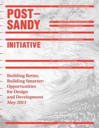
  • 1. 1 2 3 4 5 6 7 8 9 10 11 12 13 14 15 16 17 ft. ft. 0 Pre-Sandy Base Flood Elevation Sea level datum NAVD 88 Projected Year 2080 Flood Height with Sea Level Rise Projected Year 2050 Flood Height with Sea Level Rise Post-Sandy Advisory Base Flood Elevation with Residential Freeboard 2012 Sandy Surge Level Post-Sandy Advisory Base Flood Elevation INITIATIVE POST SANDY Nominal Ground Level Building Better, Building Smarter: Opportunities for Design and Development May 2013 8'10.8" 0' 16'7" 14'5" 14' 13' 12' 8'
  • 2. 16'7" Projected Year 2080 Flood Height with Sea Level Rise 14'5" Projected Year 2050 Flood Height with Sea Level Rise “Climate Change Adaptation in New York City: Building a Risk Management Response: New York City Panel on Climate Change 2010,” Annals of the New York Academy of Sciences Volume 1196, 41-62. New York, May 2010. 14' Post-Sandy Advisory Base Flood Elevation with Residential Freeboard Mayor Bloomberg Announces New Measures to Allow Home and Property Owners Rebuild- ing after Hurricane Sandy to Meet Updated Flood Standards, January 31 2013 http://www.nyc.gov/portal/site/nycgov/ menuitem.c0935b9a57bb4ef3daf2f1c- 701c789a0/index.jsp?pageID=mayor_press_ release&catID=1194&doc_name= http%3A%2F%2Fwww.nyc.gov%2Fhtml% 2Fom%2Fhtml%2F2013a%2Fpr044-13.html &cc=unused1978&rc=1194&ndi=1 13' 2012 Sandy Surge Level “NYC Storm Surge Map,” Center for the Advanced Research of Spatial Information, Hunter College, City University of New York, 2012. http://www.carsilab.org/sandy 12' Post-Sandy Advisory Base Flood Elevation (see source for 14') 8'10.8" Pre-Sandy Base Flood Elevation Federal Emergency Management Agency. “Advisory Base Flood Elevation Information, Region 2 Coastal Analysis and Mapping.” 2013. http://www.region2coastal.com/sandy/ table 8' Nominal Ground Level Federal Emergency Management Agency. Ground level at example site (111 Beach 222nd Street, Breezy Point, Queens), “Advisory Base Flood Elevation Information, Region 2 Coastal Analysis and Mapping.” 2013. http://www.region2coastal.com/sandy/table 0' Sea level datum NAVD 88 Wikipedia. “North American Vertical Datum of 1988,” last modified April 10, 2013. http://en.wikipedia.org/wiki/North_Ameri- can_Vertical_Datum of_1988 Cover Image credit: NASA/NOAA
  • 3. 1 2 3 4 5 6 7 8 9 10 11 12 13 14 15 16 17 ft. ft. 0 Pre-Sandy Base Flood Elevation Nominal Ground Level Sea level datum NAVD 88 Projected Year 2080 Flood Height with Sea Level Rise Projected Year 2050 Flood Height with Sea Level Rise Post-Sandy Advisory Base Flood Elevation with Residential Freeboard 2012 Sandy Surge Level Post-Sandy Advisory Base Flood Elevation POST SANDY Building Better, Building Smarter: Opportunities for Design and Development May 2013 INITIATIVE 8'10.8" 0' 16'7" 14'5" 14' 13' 12' 8'
  • 4. In response to Superstorm Sandy, the American Institute of Architects New York (AIANY) has spearheaded a collaborative initiative investigating issues and outlining options and opportunities to address the short-, intermediate-, and long-term impacts of the storm and the escalating effects of climate change on New York City. The impetus for this work grew in part from an informal partnership that had developed between the AIANY Design for Risk and Reconstruction Committee (DfRR) and the NYC Department of City Planning (DCP). Starting well in advance of Hurri- cane Sandy, these two groups had collabo- rated on multidisciplinary design explora- tions related to climate change. In addition, the DfRR Committee and AIANY undertook a number of other pre- and post-Sandy initiatives, including training and organiza- tion of FEMA neighborhood assessment programs and coordination of initiatives with the NYC Office of Emergency Man- agement (OEM), the Dean’s Roundtable, related area design schools, and relevant AIA National programs. After the devasta- tion of the storm, this relationship expand- ed to include a larger set of collaborators, the Post-Sandy Initiative, which prepared this summary. This Initiative includes relevant committee members from AIANY and volunteer representatives from other AIA chapters and sister organizations who share the commitment to recovery and belief that planning and design are a crucial compo- nent of rational decision-making. Numer- ous other agencies, panels, and organiza- tions have been working in parallel with this Initiative, including those convened by the Mayor’s Office, the City Council, the Governor’s Office, the Municipal Art Society, the Regional Plan Association, Pratt Institute, and many others. We intend our work to complement and support these efforts, especially those with ties to the most affected populations. The Initiative has four overarching objectives: First, to prepare a multifaceted report illuminating options and opportunities based on the best information available in a short amount of time. The report is intended to provide policymakers with additional tools as we forge ahead in response to Sandy. Second, to mount an exhibition of this open-ended information so that it can be shared, discussed, and debated by design professionals, stakeholders, and recovery leaders. Third, to initiate public symposia and ongoing programs in the four areas covered in the report, providing a framework for continued focus on Sandy recovery. Fourth, to undertake continuing advocacy with relevant public, private, and institu- tional stakeholders, expanding the re- sponse to Sandy into efforts for a more resilient future. In the wake of Sandy, it is evident that we need to learn from other cities and regions that have suffered similar weather events. These precedents serve as best practices on which we can rely as we begin to build back better and smarter. We support research into resilient measures of building, which can secure our regional future and become, in turn, best practices that can be helpful to other areas at risk. As delineated in the following pages, participants have defined a variety of short-, medium-, and long-term responses in four key areas—Transportation & Infrastructure, Housing, Critical & Com- mercial Buildings, and Waterfront—that will feed into these larger public, private, and institutional efforts. Following the release of this report, we will continue these fruitful collaborations and advocate for ensuring the health, safety, wellbeing, and quality of life of our magnificent city and region. Building Better. Building Smarter. Preface Collaborating Organizations: American Council of Engineering Companies (ACEC New York) American Society of Landscape Architects New York Chapter (ASLA-NY) Citizens Housing & Planning Council (CHPC) New York State Association for Affordable Housing (NYSAFAH) American Planning Association New York Metro Chapter (APA-NYM) Regional Plan Association (RPA) Structural Engineers Association of New York (SEAoNY) For more information on AIANY’s Design for Risk and Reconstruction Committee (DfRR) please refer to www.designforrisk.com 4
  • 5. Post-Sandy Initiative Executive Summary INTRODUCTION TRANSPORTATION & INFRASTRUCTURE HOUSING CRITICAL & COMMERCIAL BUILDINGS WATERFRONT ADAPTATION, ADVOCACY & NEXT STEPS List of Volunteers 12 8 6 43 18 26 32 40 5 Table of Contents
  • 6. Superstorm Sandy revealed that we have created a defenseless built environment: 1. Land-use patterns encourage fragile dwelling units and critical facilities in the most vulnerable locations. 2. Transportation and utility systems fail in the face of extreme weather events. 3. Stormwater management and develop- ment policies now in effect actually increase the impact of runoff. 4. Existing buildings are barriers to sustainability, squandering power and producing greenhouse gases. The overarching long-term objective is resilience, which can best be achieved by modifying buildings, transportation and infrastructure networks, and land-use patterns. XX This will require consensus on stan- dards and where they apply—what constitutes “harm’s way,” based on updated predictions of flood zones, storm surges, and sea-level rise, and how these assumptions may shift or increase in coming years. XX It will also take careful analysis of many possible strategies—examining relative costs and benefits in the context of likely useful lifespans. XX There is no universal solution. Design approaches should be site-specific and respond to local programmatic needs. A great deal of work has been published and is underway on responding immedi- ately after disasters. As architects, planners, and designers, our focus has been, instead, in an area where we can make the most meaningful contribution: design approaches to new construction and rehabilitation to help limit the effects of future storms on our built environment, and processes to help us coordinate our efforts to provide critical services, includ- ing regional transportation, immediately after a major storm. Building back better and smarter—moder- ating past mistakes through careful planning, becoming more energy indepen- dent, and requiring sustainable design and construction practices—will help reverse the vulnerability we have inherited from centuries of misguided development. before the fact and regional coordina- tion during extreme events, including emergency wayfinding strategies to inform residents about alternative backup plans for transportation, power, fuel, and locations for assistance. XX Recognize that infrastructure failures in New York City can have catastrophic international impacts. The funding required to strengthen our infrastructure should be leveraged through all parties that benefit from preventing expanding economic disorder. HOUSING Multi-family buildings fared much better than one- and two-family dwellings. Yet local and national regulations related to housing in flood zones do not address the conditions of a dense urban place like New York City. Superstorm Sandy revealed the need for new strategies to address evacuating residents who will be displaced in future disasters, and their security and comfort if sheltering in place is necessary. The existing housing stock must be retrofitted to become more resilient. Standards for new housing must ensure that it can be safe, accessible, and attractive. Key concepts and findings Housing displaced people in extreme events requires knowledge of available units, a centralized intake process, and a set of tools including appropriate waivers, qualifying processes, model lease agree- ments, and allocation of subsidies. Non-profit housing providers need support with post-disaster training to address residents’ needs, especially in flood-prone neighborhoods. Gaps in current floodproofing guidelines and regulations—at both local and federal levels—must take into account the charac- ter of dense urban environments. Multi-unit housing stock in flood zones, even where damaged, remains largely sound. With strategic modifications, the useful life of most of these buildings can be extended well into the future. Broader planning implications should be addressed, such as whether exceptions to allow multi-family housing in downzoned coastal areas could increase community resiliency. Opportunities and next steps FEMA and National Flood Insurance Program literature is largely focused on one- and two-family housing. It is our conclusion that a FEMA multi-family design guide is very much needed. Executive Summary TRANSPORTATION INFRASTRUCTURE Regional coordination and planning for redundancy can ensure that our transpor- tation and infrastructure networks will operate before, during, and after severe weather events. These aging systems were not built to withstand today’s rising sea levels and severe storms. Identifying their vulnerabili- ties and planning for their reinforcement is an urgent priority, demanding interagency collaboration, public education and commitment, and solutions that contribute to the design quality of the City and region. Key concepts and findings Planning for Redundancy: Transportation and infrastructure networks are interde- pendent. Multiple and alternative power sources can keep them functioning during severe weather events. Robust, multiple- system communication plans can alert the public to evolving conditions. Planning for Resiliency: Reinforcing vulnerable structures and repositioning critical equipment can protect vital infrastructure systems. Sensitively-de- signed elements can also serve as urban amenities. Replacement of those systems that were heavily damaged by Superstorm Sandy should maximize long-term sustain- ability. Planning Smart: We have identified case studies that reveal three distinct strategic approaches—defensive, adaptive, and passive. Defensive infrastructure can demand burdensome long-term funding and management; for each particular situation, scenario-planning exercises and other research are needed to suggest whether hard infrastructure (with a constructed resiliency) or simpler, softer solutions will best protect the community. Adaptive efforts reduce disruption of natural ecosystems, and focus on green infrastructure approaches. Passive solutions accept that protecting invest- ments is impractical in a particular situation, and focus on moving or provid- ing alternative systems. For all strategies, solutions must contribute to the ameliora- tion of service gaps and improved design quality of the public realm. Opportunities and next steps XX Assess the infrastructure and transpor- tation systems at greatest risk, and identify strategies for their redundancy and resiliency. XX Educate the public about challenges ahead to ensure realistic expectations and support for required expenditures. XX Improve interagency and interstate communications for holistic planning 6
  • 7. Post-Sandy Initiative Zoning regulations should be adjusted, in light of predicted higher flood levels, to recognize the amount of space needed by required ramps, elevators, and lifts in multi-family buildings, and to provide for the relaxation of height restrictions in order to accommodate higher-elevation ground floors. In low-income rental buildings and supportive and senior housing, where residents may not be able to individually evacuate, safe rooms and expanded programs should be provided to allow congregation, roll call, and rescue during emergency conditions. Multi-family housing should be engineered with building systems that protect against HVAC shutdowns, provide for alternative power during outages, and ensure a quick return to normal. CRITICAL COMMERCIAL BUILDINGS The challenges of adapting the vast inventory of existing critical buildings to withstand the effects of extreme climate events are distinct from the relatively easier task of designing new structures for resiliency. Critical facilities like hospitals, police stations, and data centers must be able to withstand the effects of a disaster and remain in operation without evacuation. Other buildings in vulnerable locations may be evacuated, but should be designed to survive without structural failure. Building owners have a responsibility to protect occupants, protect structures and contents from damage, and ensure that buildings can operate during and after the event. Key concepts and findings Owners of all commercial and institutional buildings—existing, in construction, or planned—should begin now to: XX Conduct vulnerability assessments of their buildings in anticipation of the likely effects of extreme climate events. XX Identify technical standards and tech- nologies that will allow their buildings to successfully withstand these events. XX Update plans to keep buildings opera- tional during disasters and to quickly recover functionality afterwards. XX Create implementation plans to put in place remedial actions indicated by the three preceding steps. Opportunities and next steps Disaster-resistant building design strate- gies, technologies, and materials that already exist or are being developed elsewhere should be examined and adapted here. We should move toward replacing existing critical buildings in harm’s way that cannot be hardened, with exceptions for buildings of historic or cultural significance. We need regional protective systems that can enhance, or eliminate the need for, individual building responses. The challenges that hurricane conditions and floods pose for buildings, in particular those in densely populated areas, should be brought to the attention of the many scientific, governmental, and professional organizations currently exploring the potential impacts of climate change. Dialogue will lead to better simulation models of water and wind behavior on built structures, a new national reference code for building construction, and zoning and planning approaches that bring patterns of development into line with present and emerging knowledge about disaster-prone areas. WATERFRONT The future of New York as a waterfront city depends on respecting our changing environment and building on the unifying strength of our dynamic harbor and waterways in creative ways. Superstorm Sandy has given us a new perspective on New York City’s diverse waterfront and watershed—comprising ocean, riverine, and estuarine systems within a broader context of interactive water flow. Floods and storm surges are part of natural cycles, although their frequency, intensity, and impact on our city are increasing. Within this ecological context, an array of opportunities exists that can integrate diverse land-uses—pub- lic access, parks, housing, commercial districts, and working waterfronts—and accommodate the climatic events we must now anticipate. Key concepts and findings More scientific research will help us to understand the interactions between urban waterfront and human ecologies. We need a dynamic and innovative approach to waterfront projects, allowing for experimentation and novel resiliency strategies. Interdisciplinary collaborations, organiza- tional structures, and funding mechanisms could promote robust collaborations among pure and applied disciplines—link- ing the design community, the scientific research community, and the regulatory community. There is always more than one solution. New York City has 520 miles of shoreline, with varying geomorphology, hydrology, land-uses, and habitat types. Planning and design of waterfronts should embrace unique, site-specific attributes. For instance, we need to set priorities for current and future funding for the alterna- tives being identified and discussed by the City’s post-Sandy task force, the Special Initiative for Rebuilding and Resiliency (SIRR). There is always more than one solution. New York City has 520 miles of shoreline, with varying geomorphology, hydrology, land-uses, and habitat types. Planning and design of waterfronts should embrace unique, site-specific attributes. For instance, we need to set priorities for current and future funding for the alterna- tives being identified and discussed by the City’s post-Sandy task force, the Special Initiative for Rebuilding and Resiliency (SIRR), the Department of City Planning’s year-long Urban Waterfront Adaptive Strategies Study, and NYS 2100 Commis- sion. These include nourishing beaches and expanding dunes, reinserting wet- lands, raising bulkheads, adding tide gates and revetments, building breakwaters, installing passive and deployable flood- walls, constructing seawalls and surge barriers, and conceiving of dual-use or multi-purpose levees. Redundancy and modularity should be built into flood protection and stormwater management systems in densely-populat- ed areas. All members of waterfront communities should be included in the planning and implementation processes via community outreach and communication. Opportunities and next steps We need a ground-up, incremental approach to waterfront resiliency, partner- ing with local communities to generate sensitively formulated solutions, and arming property owners with a menu of strategies. From government we need agility and flexibility in regulations, and funding that affects the planning and design of waterfront solutions in the context of a collaborative, problem-solving approach. We propose Waterfront Labs to investigate strategies that could mitigate storm surge, prevent erosion, and soften the impact of rising tides. Experiments would focus on both predictable and unpredictable events, and take into account the different natural typologies found in the New York City region. The Waterfront Lab will make an important contribution by bringing New York City to the forefront of innovative waterfront resiliency planning and design. 7 Executive Summary
  • 8. The cover of this report graphically quantifies Sandy’s impact—and future potential implications—in terms of comparative feet and inches. Sandy’s regional inundation levels are shown in the adjacent map. As we now understand, many of the most acute impacts of Superstorm Sandy resulted from the confluence of several unique circumstances: an off-shore hurricane that entered the New Jersey / New York City / Long Island region at full bore; a fast-rising storm surge that came and went quickly; one of the highest tides of the year combined with a full moon; a Nor’Easter, and a disturbance in the jet stream that caused the storm’s turn west into New Jersey. We need to learn from Sandy in order to address other different but equally threatening factors that may emerge from the next storms. For example, Hurricane Irene in 2011 caused flooding resulting from intense rainfall, rather than the storm-surge- driven flooding seen during Sandy. Wind damage from Sandy was limited to the area of first landfall, although tree damage and resulting power outages were major issues in adjacent inland areas. Obviously it is difficult to predict the factors and results associated with any storm. Superstorm Sandy resulted in large numbers of people losing their homes, livelihoods, and in some instances, their INTRODUCTION lives. More than 10% of the City’s population (almost 850,000 people) lived in Sandy’s Inundation Zone— over 325,000 dwelling units in 78,000 buildings (85% of which were built before 1983 flood-related building code upgrades, and over 60% of which suffered FEMA-inspected damage). The New York City Police and Fire Departments rescued more than 1,700 people, with likely many more unre- ported. While the vast majority in the region did not suffer to the degree as those in that zone, what did affect everyone unilaterally was the damage to our citywide systems: transporta- tion and utilities, housing, critical and commercial buildings, and the water- front. The energy infrastructure was damaged along the regional supply chain of fuel terminals, pipelines, and gas stations. Hundreds of thousands were without power—approximately 80,000 residents in more than 400 New York City Housing Authority (NYCHA) buildings were affected by loss of electricity, heat, or hot water. The storm revealed vulnerabilities across the Tri-State Area and focused atten- tion on the question of long-term viability. Since October 2012, numer- ous initiatives are under way at local, regional, and federal levels to deter- mine how to respond to future impacts from such storms, which are antici- pated to happen with even greater frequency and intensity. 8
  • 9. Post-Sandy Initiative Superstorm Sandy Surge Infiltration MapSource: MOTF Inundation Model Date: April 3, 2013 © 2013 ESRI, DeLorme, NAVTEQ 9
  • 10. Sandy’s unexpected power and breadth created a need for realistic standards to protect communities in the way of future storms—which may be even more powerful in terms of wind, rain, and potential damage. This unprecedented challenge, complicated by estimates of rising sea levels and increasing frequen- cy of events, will define how we plan and regenerate the inundated areas and the regional context. Even as people and buildings suffered terrible direct impacts, the City and region as a whole suffered massive indirect impacts of the storm. Adverse effects to economic vitality, communica- tions infrastructure, and connectivity networks were widespread. The initial step in any disaster is response, preserving life and critical property in the midst and immediate aftermath of the event (ideally preceded by effective pre-planning for evacuation and staging of needed resources). This is followed by recovery, returning to as much normalcy as possible, in turn followed by organized and deliberate rebuilding. The overarching long-term objective is resilience—modifying buildings and land-use patterns over time, and infrastructure where significant investment prevents physical relocation, and waterfront edges that transition between the shore and upland areas— hardening and/or softening as relevant to mitigate the impact of future events. In order to deal with these challenges, Mayor Michael Bloomberg’s Special Initiative for Rebuilding and Resiliency (SIRR) program is engaged in preparing an integrated strategy to address how we rebuild New York City to be more resilient in the wake of Hurricane Sandy, but with a long-term focus. The City will use its first allocation of federal Commu- nity Development Block Grant (CDBG) funds to support recovery from Sandy and to build in resilience to the challeng- es of climate change, including programs to build and support housing, businesses, infrastructure, and other city services. This process, undertaken through the coordination of numerous governmental agencies and multidisciplinary advisors, relies heavily on community outreach to define issues and priorities. As planning and design professionals, our intent is to support that process through our parallel volunteer efforts. But as we step back from the immediate shock and imperative response to emergency conditions, we must recog- nize that much of the problem lies in our own culpability as a client society—the way we have helped over the years to create a susceptible built environment: XX Land-use patterns that encourage fragile dwelling units and critical facilities in the most vulnerable loca- tions; XX Transportation and utility systems that fail more and more frequently in the face of natural events; XX Stormwater management and develop- ment policies that increase rather than decrease the impact of runoff; XX Existing buildings that are barriers to sustainability—and that, in NYC, use 94% of electrical production and produce 75% of greenhouse gas emissions. Overall, sea levels are rising and extreme storm events are becoming more frequent, both because of natural cycles and the worsening impact of human- induced climate change. By building back better and smarter—moderating our past poor decisions through careful planning, becoming more energy-independent, and setting in motion new, sustainable design and construction practices—we can begin to mitigate or reverse the effects of centuries of misguided devel- opment policies. The Post-Sandy Initiative The Post-Sandy Initiative, the collabora- tion that produced this summary report, is structured as the planning and design community’s response to this challenge. Initiated by the American Institute of Architects New York (AIANY) in the weeks that followed the storm and in collaboration with a wide range of other professional organizations and con- cerned individuals, it has been supported by the participation of a variety of local, regional, state, and national public agency participants. At publication time, still only months after Sandy swept through our region, this report is a slice in time of our efforts as of April 2013— a definition of issues, an analysis of options and opportunities, and the establishment of a framework for next steps. As our community continues to explore these issues and develop ideas for building better and building smarter, progress reports will be issued online at www.postsandyinitiative.org Unlike many of the areas devastated by comparable American storms, New York City is a major urban region whose vitality and resiliency depends on a complex web of interconnected systems. With more than 8 million residents, 6 million commuters each day, and 50 million annual visitors, New York City is the largest regional economy in the United States, and the second largest city economy in the world after Tokyo. New York is a cultural capital and home to hundreds of museums, performing arts venues, and historic sites; and more than 600,000 students are enrolled at the City’s 110 higher education institutions, a larger number than the entire population of Boston. Through the Post-Sandy Initiative’s working groups, it quickly became clear that “one size does not fit all”—the imposition of national or other stan- dards, often based on rural, suburban, or small-city situations, may not always be applicable to our high-density envi- ronment, and falls short in addressing our complex, interconnected social and economic culture. A series of comple- mentary initiatives, many based on experience from outside the United States, is required to affect meaningful change. As part of this Initiative, many profes- sionals have given their time to explore important issues about Sandy and the response to date, both in terms of shorter-term recovery efforts and longer-term resiliency considerations. It is clear that we can, and need to, do better in the face of future extreme weather events. Key areas for further discussion include: During a major storm event: XX Dealing with governmental/OEM and FEMA evacuation mandates in the face of concerns such as public housing 10 Introduction
  • 11. Post-Sandy Initiative constraints, property owner reluctance, and public safety considerations; XX Ensure that evacuees have places to go out of harm’s way, and reliable means to get there; XX Reinforce and protecting building systems, infrastructure function, and ability to provide police and fire protection. Short-term recovery: XX Assess the damage to property and community; XX Provide equitable public support in the face of varying insurance coverage; XX Justify and balance rapid-recovery efforts and costs with follow-up repairs; XX Define the standards for remediation, and resulting costs, in terms of medium-and long-term benefits; XX Understand the implications of insur- ance rates based on those standards, and their impact on property owners of various incomes. Medium-term remediation: XX Define workable standards for both relatively easier new construction and significantly more difficult existing repair and reconstruction; XX Develop approaches for rebuilding based on sustainability and resource conservation; XX Establish clear standards from amongst differing expectations on the rate of climate change and sea-level rise predictions; XX Deal with social inequity, community, and economic issues of long-term settlement in areas that are now in harm’s way; XX Create equitable (and appropriately funded) programs for purchase of destroyed or damaged homes and transference into open space. Long-term resilience: XX Analyze long-term infrastructure and waterfront investments despite a lack of definitive new scientific standards for flood zones and sea-level rise; XX Evaluate how to finance premiums for design and construction based on short-term cost but long-term benefit without affecting immediate alternative needs or choices; XX Advocate planning and design solu- tions that reduce carbon emissions and our reliance on fossil fuels, as well as work with anticipated future water levels. There are two major determining factors in defining resilience: XX Achieve consensus among the respon- sible parties (FEMA, the states, the City, and other municipalities, insurance companies) as to standards— what constitutes “harm’s way.” This defini- tion will necessarily be based on predictions of sea-level rise, possible storm surges, and recommended allowances for “freeboard” above those flood levels—and how they are predicted to increase over a series of benchmarks throughout the coming century and beyond. XX Careful cost-benefit analyses that take into account funding cycles and the benefits of funds at the users’ end, present value, and alternative uses of funds. As the planning and design community, we are one voice in these critical issues. But our expertise and perspective are invaluable components of the solution. Architects, landscape architects, plan- ners, and engineers must be at the table as policies and standards are developed to mitigate or reduce the risk of cata- strophic damage from the next storm. We must apply our experience to those issues that speak to the physical, social, and environmental implications of possible decisions. More value and emphasis must be placed on long-range comprehensive planning under the initiative of elected leaders. Systems and resources must be organized so that short-term decisions are aligned with long-term health, safety, and sound investment. We framed this Post-Sandy Initiative in terms of design implications and applied design thinking. A set of working groups examined key aspects of the built environment in detail, through collabora- tion, research, workshops, and design charrettes. We have examined these topics in terms of short-, medium-, and long-term time frames, and at a range of scales, from individual buildings to neighborhood contexts, the surrounding city, and the region as a whole. The following chapters summarize issues, options, and opportunities identified by four of these working groups—Transportation Infrastructure, Housing, Critical Commercial Buildings, and Waterfront. The valuable work of a fifth working group—Zoning Codes—has been incorporated throughout the text. Each of these reports is supplemented online by additional material delving into specific areas of concern and concepts for building better and building smarter at www.postsandyinitiative.org The overarching long- term objective is resilience—modifying buildings and land- use patterns over time, infrastructure where significant investment prevents physical relocation, and waterfront edges that transition between the shore and upland areas — hardening and/or softening as relevant to mitigate the impact of future events. 11 Introduction
  • 12. Public transportation entities such as the Metropolitan Transportation Authority (MTA), NJ TRANSIT, the Port Authority of New York New Jersey (PANYNJ), and Amtrak are all re-examining Sandy’s impacts and developing short- and long-term responses to climate change within the context of restricted budgets and smaller workforces. City agencies responsible for infrastructure—sewer, water, and stormwater drainage—are examining failures and planning for future needs. Power utility providers such as ConEdison, LIPA, and PSEG are developing new strategies. Advocacy groups such as the Municipal Art Society (MAS), the Regional Plan Association (RPA), and the Rudin Center for Transportation have served in multiple roles, from educating the public through public dialogues and white papers, to lobbying for funding and improved communication among infrastructure and transportation providers. It is critical to understand all of these ongoing efforts while working across disciplines that cross municipal and state lines. Interagency collaboration and a well-developed communica- tions plan established jointly by various transportation and infrastructure agencies that serve the City and region can strengthen the framework for future multi-modal redundancy and resiliency. Regional coordination and planning for redundancy can ensure that our transportation and infrastructure networks will operate before, during, and after severe weather events. TRANSPORTATION INFRASTRUCTURE 12
  • 13. Post-Sandy Initiative KEY CONCEPTS AND FINDINGS As noted in Governor Andrew Cuomo’s NYS 2100 Commission report, “Recom- mendations to Improve the Strength and Resilience of the Empire State’s Infra- structure” (November 2012), New York State’s recent ClimAID projections show that higher temperatures and sea-level rise are extremely likely for New York State through the end of the century, and that by 2100, experts project sea levels to rise in New York City and Long Island by as much as six feet under certain scenarios. Given our aging transportation and infrastructure, those statistics make identifying the weak- nesses in our systems of utmost urgen- cy. The following strategies are our recommendations for responding to the new anticipated norm. Planning for Redundancy Planned redundancy provides a more flexible infrastructure. As many of our transportation and infrastructure networks are interdependent, losing one often causes the loss of others. Working towards providing appropriate backup power systems along with alternative power sources, such as solar, wind, or geothermal, will make grid dependency less critical. Policies that encourage redundancy would promote these actions. Developing a robust communications network and plan will allow transporta- tion agencies to alert the public about station closings and alternate transpor- tation routes, prior to and immediately after severe storm events. Planning for Resiliency There are currently available physical solutions that can protect our transpor- tation and infrastructure networks against flooding. Sensitively designed, these barriers can also serve as urban amenities. By reinforcing vulnerable structures, we can fortify them to withstand these “new normal” events. These actions should be supported by policies that address strengthening existing structures with ongoing repair programs, as detailed in Section 3 on critical and commercial buildings. Placing new electrical equipment above anticipated flood levels and replacing damaged equipment with new equip- ment designed to work in a harsh salt-water environment are examples of strategies that could be implemented as part of an overall plan. As we move from short-term recovery to long-term planning for redundancy and resiliency, we need to plan smart so we can build smart. Planning Smart Smart planning in the new ecosystem involves looking at transportation and infrastructure systems in new ways. It begins with an intermodal interagency process of regional cooperation, commu- nication, and coordination for standard operations, regular outages, and extreme weather situations. Once in operation, New York City’s CitiBike program will provide alternative transportation for some residents. Photo credit: CitiBike / NYC Bikeshare Temporary flood barriers were constructed prior to the storm at vulnerable entrances. Photo credit: Flickr / MTA Photos Photostream 13 Options and Opportunities: Transporation Infrastructure
  • 14. It includes recognizing the efficiency of having tunnels act as drains for our cities, and considering the different ways that systems can function during severe storms, and how that differs from how they perform during a non-event. Providing uninterrupted services at vital facilities such as hospitals, firehouses, and shelters should be prioritized as part of an overall infrastructure network. Planning smart means examining existing and new infrastructure compre- hensively with a clear understanding of specific risks that vary based on loca- tion. Building better will mean coordi- nating systems between agencies serving the same region, and acknowl- edging that often a replacement in-kind is not an adequate solution. To plan smart, we need to enhance our guidelines and standards for resiliency and redundancy by integrating the following best practices: New Infrastructure The Inner Harbor Navigation Canal Surge Barrier in New Orleans (the only one like it to date in the United States), London’s Thames Barrier, and the Delta Works in the Netherlands are examples of climate change-responsive infrastruc- ture solutions that are less than 30 years old. These structures typically need to be funded from design through con- struction and maintenance. As an example, sewage treatment failures in extreme storm events may require long-term funding of a hardened system to mitigate such problems in future storms. We recognize that in our region, these new types of infrastructure will need to be developed and maintained by a new public institution, or added to the responsibilities of an existing one. Scenario-planning exercises in different communities, similar to what is being demonstrated as part of Mayor Bloom- berg’s citywide Special Initiative for Rebuilding and Resiliency (SIRR), can further inform how soft solutions or hard infrastructure can protect communities from severe storms like Sandy, and how they may either detract from or enhance those communities’ quality of life. Reduce Impact to the Ecosystems New York City already has one of the lowest carbon footprints per capita in the country. As we develop these recommendations, we must continue to reduce this footprint and reinforce our city’s approach to sustainability, ensur- ing that our redundancy recommenda- tions reduce negative environmental impacts as well. The use of permeable paving materials and water retention systems that reduce the demands on sewer systems are two such viable possibilities. Another is to encourage less energy-dependent transportation modes, such as bicycle and pedestrian networks and technologies, as part of the overall regional transportation system. It will also be important to look at areas and communities that may have been underserved in terms of a broader adoption of green infrastructure mea- sures, and how that, in fact, may mini- mize flooding in the future. G-Cans Project, Tokyo, Japan One of the world’s largest underground flood-water diversion facilities was designed to protect Toyko from flooding during typhoon season and heavy rains. 14 Options and Opportunities: Transporation Infrastructure
  • 15. Post-Sandy Initiative Urban Design Quality Part of building for a resilient future is protecting our communities from problems resulting from climate change, and doing so in a way that uses natural as well as engineered measures to improve both redundancy and resiliency. Neither measure should, however, exclude maintaining the quality of the built and natural environment. There- fore, it is critical to solve these technical challenges in a way that does not lose sight of the human condition. Solutions must generate positive interventions from architectural and urban design perspectives. We must not forgo the vitality of our built environment, and in cases where communities may have been underserved aesthetically, address infrastructure and transportation needs as an opportunity for both urban and economic enhancement. Responses Prior to Catastrophic Events Having plans in place for catastrophic events, and communicating them to the public, is a low-cost initiative that pays dividends. Procedures to close transpor- tation systems in order to safeguard transportation and infrastructure networks (including relocating mobile equipment to higher ground, installing temporary flood barriers, etc.), and requiring mandatory evacuations of vulnerable areas must be developed. This would increase safety and security during a storm. The MTA and the City of New York taught this lesson to millions. A regional process for communicating station, road, and line closures to the public prior to severe weather events— and providing clear information about alternative routes—should be developed and employed, as mentioned above. Responses to Catastrophic Events After the Fact The recovery after Superstorm Sandy was uneven, and for many residents, not knowing when essential services would be restored was more difficult to accept than the event itself. Implemen- tation of the strategies summarized previously, in particular the redundant and resilient systems, will help to mitigate future similar challenges. Additionally, local outreach facilitators should be trained to educate communi- ties about their various transportation options. Key information points can be established in advance so that in the event of a broad-based Internet shutdown, data on current and planned operations are accessible throughout the City. Details on alternative trans- portation systems, including bike routes and ferries, should be well distributed. Workforce development programs can help to lessen post-cata- strophic isolation. There remains much that can be done. Our institutions need to treat the “catastrophic” as “expected” and prepare accordingly. Doing so may change the “catastrophic” to merely “inconvenient.” POLICY CONSIDERATIONS AND REGULATORY IMPLICATIONS Transportation and infrastructure, when compared to other aspects of the built environment, are far more developed, controlled, and managed by public agencies. Responsive programs will necessarily be filtered through government programs and regulatory modifications. This includes agencies such as the Federal Emer- gency Management Agency (FEMA), the Federal Transportation Administra- tion (FTA), the Federal Aviation Administration (FAA), the Environmen- tal Protection Agency (EPA), MODE 1 Normal Conditions 2 Roadways Open MODE 2 Moderate Storms 1 Roadway Open MODE 3 Heavy Storms 0 Roadways Open SMART Tunnel, Kuala Lumpur, Malaysia The SMART tunnel is six miles long and consists of two tubes, each carrying two traffic lanes, situated one above the other. The tunnel is used to manage severe flooding during monsoon season. Its mechanical and electrical equipment can handle submersion to a depth of 65 feet during flooding. 15 Options and Opportunities: Transporation Infrastructure
  • 16. the Federal Highway Administration (FHWA), and the Federal Railroad Administration (FRA). To fund the responses to climate change, sea-level rise, and potentially catastrophic natural events, we must demand a new paradigm of investment. With federal support in place for a considerable amount of repair work, how can we refocus the discussion on longer-term capital needs? And where will the money come from? OPPORTUNITIES AND NEXT STEPS We must maintain a sense of immediacy. Keeping awareness of these issues front and center needs to continue and be brought to the transportation and infrastructure conversation if we are going to evolve these ideas into tangible next steps. When it comes to transportation and infrastructure, the responses will come from the public, with advocacy groups helping to inform decision makers. This starts with education. The public must be educated about the challenges ahead so that their expectations are realistically maintained within the context of this new reality. Cooperative efforts need to continue on a regional level. This begins with shared knowl- edge, including lessons learned, followed by the development of coordinated common standards and guidelines. Therefore, we need to improve interagency and interstate communications so that we are plan- ning holistically and not in geographic vacuums. We must advocate for methods of sharing information, we must advocate for methods of sharing information, especially during a crisis. This should include emergency way- finding strategies to inform residents about alternative backup plans for transportation, power, fuel and loca- tions for assistance. Ultimately it is about risk management. How do we (stakeholders, the public, decision makers, government, and advocacy groups) navigate through this Thames Barrier, Thames River, London, UK Designed by Rendel, Palmer and Tritton to prevent flooding from high tides and North Sea storm surges, the Thames Barrier is located downstream from central London. It needs to be raised (closed) only during high tide; at ebb tide it can be lowered to release the water that backs up behind it. Photo credit: Bikeworldtravel / Shutterstock.com MuseumPark, Rotterdam, The Netherlands Underground parking garage designed by Paul de Ruiter Architects accommodates 1,150 cars and a 10-million-liter water reservoir, when necessary. Photo credit: Pieter Kers 16
  • 17. Post-Sandy Initiative historical moment in the Northeast? If we are to continue living and working here, we need to recognize all these issues, and then manage the associated risks. Superstorm Sandy forced us to recognize the fragility of our position, with millions of people from New Jersey to New England affected. Now we have to manage it. We need to begin to assess the transportation and infrastruc- ture systems that are at greatest risk, and then identify and prioritize strate- gies for redundancy and resiliency in the near and long term. It is clear that we need to expend the resources that can manage these risks. The challenge will be for the public to accept these expenditures as part of a new standard, and for the agencies that are their guardians to strengthen interagency communications during severe climatic events. New York City, as a global city, is linked inextricably with the rest of the world. That global interdependency means that minimizing the health and responsive- ness of our transportation and infra- structure networks can result in cata- strophic impacts throughout the world. The funding necessary to manage risks and sustain the continued strength of the region should be leveraged through all parties that benefit from this truly vital region. STRATEGIC APPROACHES Case studies from around the country and the world reveal three distinct strategic approaches: Defensive, Adaptive, and Passive. A defensive approach implies that the subject is being attacked and must be protected. A boundary is employed like a fortress to resist the elements. These defensive approaches offer varying degrees of effectiveness, resiliency, and environmental impact, and require ongoing operations and maintenance programs. An adaptive approach implies a balance between the need to protect and the acceptance of the overwhelming forces of nature. We adapt by altering the subject to live in symbiosis with the threat. If we embrace adaptive as co-existence, then solutions will become more apparent in adapting to the new normal. A passive approach implies recognition that the forces of climate change have or will have such a great impact that they have won. We accept their overwhelm- ing power completely, and the solution is to live with and embrace the threat. Sidewalk Gratings, Queens, NY, USA MTA commissioned raised sidewalk gratings to mitigate local flood-waters at existing subway ventilation structures. Rogers Marvel’s adaptive approach serves as a bench, adding a streetscape amenity. Photo credit: David Sundberg/Esto 17 Options and Opportunities: Transporation Infrastructure
  • 18. HOUSING Local and national regulations related to housing in flood zones do not address the conditions of a dense urban place like New York City. The Post-Sandy Housing Working Group’s focus was to learn what happened during Sandy and why, and to use these lessons to: XX Encourage the development of new strategies to address the evacuation and temporary rehousing of those dis- placed by future disasters; XX Make existing housing stock more resilient; XX Ensure that future housing is built in a way that is safe, resilient, and beautiful. An analysis by NYU’s Furman Center for Real Estate and Urban Policy and the NYC Department of City Planning revealed a few clear patterns about what worked and what did not work in residential construction. Buildings built to modern floodproofing standards fared much better structurally than older buildings. 84% of the buildings in the flood zones were built before 1983, when New York City incorporated floodproofing requirements into the Building Code. 94% of the red-tagged buildings (i.e., those requiring repair before occupants can re-enter) were built before this date. 98% of the destroyed buildings were built before this date. Retrofitting existing housing stock and rebuilding new housing to higher, more stringent standards will require changes to the multilayered regulatory climate currently governing floodproofing issues. Also needed are creative approaches to ensuring that these changes result in safer, more resilient, and beautiful buildings and communities. Multi-family buildings fared much better than one- and two-family buildings. 90% of the red-tagged buildings were one- and two-family buildings, even though they made up less than 30% of the floor area of all red-tagged buildings. Local and national regulations related to the design and construction of housing in flood zones have yet to take into account issues related to floodproofing in the country’s densest urban environments. As building owners have moved on from immediate post-disaster recovery efforts and take the next steps to make their buildings more resilient in a post-Sandy world, the need for more attention to the future floodproofing needs of multifamily buildings has become clear. The work by CHPC, NYSAFAH, and AIANY after Sandy revealed several issues related to displacement and rebuilding. These include: the need for organizational structures for non-profit housing providers to work together after such disasters; the potential for alternate solutions to the trailers and other temporary housing deployed after Sandy; and the need for protections that allow design professionals to play a constructive role in addressing emergency situations (the Good Samaritan Law). CHPC has recently employed a full-time Fellow who has established Zone A New York, Inc., a non-profit organization working on the ground building capacity and charged with addressing many of the key priority items outlined by the Housing Working Group. 18
  • 19. Post-Sandy Initiative The Post-Sandy Housing Working Group is a partnership of six professional organizations: American Institute of Architects New York (AIANY) American Society of Landscape Architects New York Chapter (ASLA-NY) American Planning Association New York Metro Chapter (APA-NYM) The New York City Bar Association, Committee on Land-use and Zoning Structural Engineers Association of New York (SEAoNY) American Council of Engineering Companies of New York (ACEC New York) These organizations were joined by four housing policy organizations: Citizens Housing and Planning Council (CHPC) New York University (NYU), Furman Center for Real Estate and Urban Policy New York State Association for Affordable Housing (NYSAFAH) Regional Plan Association (RPA) KEY CONCEPTS AND FINDINGS Five months after Sandy, the short term has already come and gone. The Hous- ing Working Group accordingly focused on mid- and long-term recommenda- tions, particularly the most important needs and priorities. We identified six priority areas for the design commu- nity’s attention. Post-disaster measures to house people displaced from their homes NYSAFAH’s experience coordinating the use of vacant apartments for temporary housing for people displaced by Sandy showed that there are alternatives to mobile homes or other temporary housing. However, the currently low vacancy rate and issues of supply vs. demand complicated this. Learning from Sandy, they recommended the following ideas to prepare for future disasters: XX Develop an outreach strategy to communicate with building owners on available vacant units; XX Develop a centralized intake process for applications and referrals for displaced households; XX Identify waivers necessary for the rehousing process; XX Identify and craft a model third-party lease agreement for households seeking temporary housing; XX Adopt an expedited qualifying process for displaced households applying for permanent affordable housing; XX Advocate for allocation of disaster- related Section 8 vouchers for house- holds below 30% AMI. As for the regulatory requirements for design and construction of buildings, many of these are affected by overlap- ping regulations that make sense in normal times, but are not set up to deal with issues of housing after disasters such as Sandy. Capacity building The period after Sandy revealed an absence of organizational structures to support the efforts of non-profit housing providers trying to work together. Two key priority areas were identified: XX Establishing programs in post-disaster training for non-profit leadership; XX Establishing a new citywide non-profit organization charged with addressing the needs of residents living in Zones A and V neighborhoods. The Working Group also benefited from the participation and support of a number of public agencies including the New York City Department of City Planning (DCP), the New York City Department of Buildings (DOB), the Mayor’s Office of Housing Recovery Operations, the Mayor’s Office of Emergency Management (OEM), the New York City Housing Authority (NYCHA), and observers from the Federal Emergency Management Agency (FEMA). 19 Options and Opportunities: Housing
  • 20. Changes to the existing patchwork quilt of floodproofing regulations The NYC Zoning Resolution, NYC Building Code, FEMA design standards, and federal accessibility guidelines all address floodproofing issues to some extent. However, as may be expected, these regulations are not fully coordi- nated. Through a multidisciplinary Post-Sandy Housing Charrette, the Working Group generated a series of recommendations for addressing gaps both within and between each of the set regulations pertaining to floodproofing. Retrofitting existing multi-unit housing stock New York is a growing city with limited land. In most cases, multi-family build- ings in the flood zone were heavily damaged, but by and large remain structurally sound. These buildings, particularly those owned by the New York City Housing Authority (NYCHA), represent a significant portion of the City’s low-income housing inventory and would be exceedingly costly to replace. With strategic modifications, the useful life of most of this stock can be extended well into the future. Create a body of literature to guide the future floodproofing needs of multi-family buildings, available in various languages Local and national regulations related to the design and construction of hous- ing in flood zones have not fully taken into account what is required for flood- proofing in dense urban environments. Study the broader planning implications The specific focus of the Housing Working Group was the scale of the individual residential building. During the course of our work, however, many questions regarding larger planning and policy decisions were raised: Given the likelihood of rising sea levels, for instance, should building codes require that buildings in the City’s coastal zones be designed for higher flood levels than currently projected? Should recent downzonings in coastal areas be reexamined to understand whether allowing exceptions for multi- family housing could increase the resiliency of these communities? How can other equally threatening factors that may emerge from the next storm, including flooding resulting from intense rainfall and wind, be addressed? It is the hope of the Housing Working Group that its work and recommenda- tions will be considered and used by the responsible agencies. It should be stressed that the conclusions and recommendations in this report do not represent the policies or recommenda- tions of any one of these individual groups or agencies. Interventions for single-family bungalow housing stock were explored through charrettes. 20 Options and Opportunities: Housing
  • 21. Post-Sandy Initiative POLICY CONSIDERATIONS AND REGULATORY IMPLICATIONS Local and national regulations governing the design and construction of housing in flood zones have not fully taken into account what is required for floodproof- ing in the densest urban environment in the country. The New York City Zoning Resolution, the New York City Building Code, FEMA design standards, and federal ADA guidelines all address flooding issues to some degree. How- ever, these regulations are not fully coordinated, so a requirement stated in one may be in conflict with another. As a result of the multidisciplinary charrette held in February 2013, the Working Group generated several recommenda- tions, which will need to be verified and modified based on specific neighbor- hood characters, building types, and site conditions. NYC Building Code XX Permit handicapped lifts in flood zones; XX Wet floodproofed buildings should have an emergency exit at the first floor above flood elevation; XX As an alternative to floodproofing individual buildings, allow block-wide or neighborhood-wide floodproofing. NYC Zoning Resolution XX Once a Design Flood Elevation of three feet is reached in a residential building, its first residential floor should be allowed to be raised to ten feet, without maximum building height penalty, so as to create a full-height floor at grade. This would allow a full-height lobby and elevator, providing an accessible common entrance at grade for all residents, and use for storage or parking or community space. XX In an existing building, if the ground floor cannot be used, expansion should be permitted horizontally or vertically, where possible, to make up for lost habitable space. Once raised, ground floor planes can be activated by retail and community facilities. XX Make alignment provisions in contex- tual districts more flexible. In some cases they currently prevent setting a building far enough from the property line to have a ramp composed of a flood-dampening landscape or perme- able paving in front of the building. XX Where a building may have to be set back from the street line to accommo- date flood zone-related steps and ramps, rear yard requirements should be reduced. XX Study of more flexible zoning enve- lopes should be undertaken so that moving more of the mechanical spaces above the flood zone is encouraged. XX Allow electric rooms to be floor-area deductible. XX Permit mechanical equipment in rear yards above flood elevation. XX Rezoning should allow for greater density in return for greater landscape buffer zones in the flood zone. 21 Options and Opportunities: Housing
  • 22. XX Stairs with natural light should be deductible, as is already encouraged in quality housing zoning for corridors in buildings in contextual districts. FEMA XX Dry floodproofing of lobbies, currently permitted for mixed-use residential only, should be allowed for all multi- family buildings. XX Evacuation in place—FEMA’s objective is to evacuate flood areas before floods occur, and to minimize the risks, especially to first responders. This may not always be possible in a dense urban environment such as New York. It is important in a flood event that those who do not follow government orders, for whatever reason, have a way to get out of their buildings and to safety during a flood. Accessibility Regulations XX Entrances and ramps that lead to the interior of the primary lobby should be permitted. Changes in National Flood Insurance Policies The National Flood Insurance Program (NFIP) was recently changed so that rates for buildings that meet floodproof- ing requirements will be significantly lower than rates for buildings that do not. This will mean that many building owners who cannot afford to meet the requirements will not be able to afford flood insurance. This is particularly true of one- and two-family and attached row houses within the flood zones, where modifying the buildings may be as costly as building new. Therefore, many buildings will not get insurance and cannot be upgraded to current flood- proofing standards. This creates poten- tial risks and costs for the City and other levels of government when the next catastrophic storm hits. For existing buildings in the new or expanded flood zones, particularly one- and two-family detached and attached homes, renewing insurance will require much more robust flood- proofing measures. These measures are likely to be costly. Efforts should be made to develop more affordable floodproofing options such as active bar- rier installations. Techniques to collec- tively fund and maintain such systems, which would decrease costs to individu- al homeowners, are used successfully in places like Prague in the Czech Republic and should be studied. Other Issues XX Illegal basement apartments in build- ings in the flood zone. While there is no definitive count of how many exist, there are vast numbers of such units that cannot be re-inhabited. This will be a hardship for displaced renters and owners who are dependent on this income. XX Dealing with the regulatory impedi- ments to short-term rental of vacant housing units (see Appendix posted on www.postsandyinitiative.org) XX A Good Samaritan law for design professionals. Options are being explored that combine wet-proofing and dry-proofing. 22 Options and Opportunities: Housing
  • 23. Post-Sandy Initiative 1. The Building Rising Ground Floors 2. The Problem 3. Raise the Building 4. Support the Building 5. Enter the Building What do we do with the ground floor? Pushes building back. Ramp may be too long to fit. 6. Enter the Building 7. Enter the Building II Permitted in mixed buildings either wet or dry flood proofing Residential buildings only wet floodproofing. 8. Enter the Building II 9. Enter the Building II Do we need emergency exit for floods? Required for dry flood- proofing. 10. Enter the Building III Primary entrance is not accessible. If Ramp is in Lobby OK. NYC does not permit lifts. Credit: Curtis+Ginsberg Architects 23 Options and Opportunities: Housing
  • 24. The Broader Context Although the charge of the Working Group was to focus on individual residential buildings, many questions regarding larger planning and policy decisions were raised. Should the building code require that buildings in the City’s coastal zones be designed for higher flood levels than currently projected? Or, if possible, should we find ways to return vacant or irrevocably damaged sites to soft-edge conditions (a program initiated by New York State on Staten Island)? Newly published projec- tions on sea-level rise should be closely studied in conjunction with the now updated FEMA flood maps. Regulations could, for instance, permit or encourage floodproofing in the 500-year flood zone. Over the last twenty years, many low-density areas of the City have been downzoned. For a variety of reasons described elsewhere in this chapter, multifamily buildings are more resilient and easier to retrofit to incorporate floodproof features. In addition, efficien- cies of scale allow emergency systems that facilitate faster reoccupations of multifamily buildings in flood areas. In coastal areas, these downzoned areas should be reexamined. OPPORTUNITIES AND NEXT STEPS FEMA Multifamily Manual Existing FEMA literature had tremen- dous value in getting the Working Group up to speed. However, regarding residential construction, the current FEMA and National Flood Insurance Program (NFIP) literature are largely focused on one- and two-family housing and fail to cover many issues related to multifamily housing. The Housing Working Group has identified several areas where we believe that we can be of help to FEMA in outlining, and perhaps helping to author, a FEMA multifamily design guide. Design of Areas Below Base Flood Elevations Careful design of spaces below the base flood elevation (BFE) is important for all types of housing. It would be expected that only water- and mold-resistant materials be used below the BFE no matter the housing type. Multifamily housing structures, however, often differ from one- and two-family buildings. Based on height, longevity, and combus- tibility concerns, multifamily housing typically incorporates robust materials such as masonry and concrete. During Sandy, it became clear that these structures performed better than the wood framing typical of one- and two-family homes. When flood elevations rise, minimum required elevations for residential spaces rise, and with these increased elevations come the vertical convey- ances needed to get people to those elevations. In one- and two- family housing, where accessibility rules do not apply or are often less stringent, stairs can be used for elevations too high for ramps. Because of a multitude of accessibility regulations, multifamily housing typically must incorporate ramps, elevators, and lifts. Zoning regulations should be adjusted to recognize the amount of space these features occupy. For instance, as BFEs exceed three feet above grade, we recommend that first-floor residential be permitted to be raised to ten feet without maximum building height penalty, so that a full-height lobby can be accessed at grade and dry- or wet- floodproofed as required for common access to an elevator. On-Site Evacuation and Areas of Refuge When it comes to occupants’ life safety at the time of an impending storm, evacuation is the best policy, regardless of housing type. Yet several external factors combine to make evacuation from multifamily housing more difficult, placing rapid post-storm re-occupation of homes more critical. Multifamily housing often occurs in dense, urban communities that are transit-dependent, like New York City. But as Sandy has shown, mass transportation may be affected by or limited during an emer- gency, and mass evacuations can lead to congestion and a reduction in mobility. Two types of specialized multifamily housing present particular challenges to evacuation, and underscore the need to address the issue of those who may not be able to leave their homes. First, low-income rental buildings, where residents may not possess cars, or the resources to move to temporary hous- ing. Secondly, supportive and senior housing where residents may be at- tached to their permanent homes because of medical or disability con- cerns and cannot easily transport themselves elsewhere. To address these situations, the Working Group recom- mends identifying a safe room (most likely, a community room) that can be used for congregating, roll call, and rescue during emergency conditions. Building Systems Multifamily housing should be engi- neered with building systems that protect against building shutdowns during emergencies and ensure a quick return to normal or standby functions post-event. One example is reliance in municipal utility-provided electricity. One- and two-family home operators may opt to partially power their homes with oil-fueled generators. This is not an option for multifamily housing. Mid-rise multifamily housing is, how- ever, a good candidate for the use of emergency generators wired to a transfer switch with emergency power circuits. In high-rise construction, in fact, the Building Code requires this. In New York City, more and more buildings are installing city-piped natural gas-fueled generators; this trend may have broader policy implications given the fact that the City gas supply has not been inter- rupted during major storms. We believe there are additional opportu- nities for emergency generators to be used for cogeneration. Cogeneration, in which heat entropy generated in the process of creating electric power is captured for heating and domestic hot water, is most efficient in multifamily housing, particularly in projects of 100 or more units. With cogeneration’s 24 Options and Opportunities: Housing
  • 25. Post-Sandy Initiative transfer switch and emergency circuitry also comes the opportunity to wire renewable power sources, such as photovoltaic panels and wind turbines, into the building for safe use during power outages. This would allow fire pumps, elevators, emergency lighting, refrigerators, and even a convenience outlet in each apartment to remain operational. It would also provide for heat and hot water to remain available via cogeneration. Finally, high-perfor- mance building envelopes, which are increasingly required and more likely to be financed for multifamily housing projects, could contribute to the efficien- cy of backup systems. Best Practices The Housing Working Group contacted AIA, ASLA, and APA chapters around the country, asking for best practices in floodproof design. We developed a form to collect information in an organized and comparative format listing project location, housing type, flood elevation data, design strategies, flood-based regulatory actions, lessons learned/ recommendations, and project graphics. All of these documents are catalogued and appear in the online appendix. These materials include methods for installing removable dry-flood barriers to existing buildings as used in Coney Island, and the Pontilly Neighborhoods Association’s work in New Orleans, where landscape architects used flood mitigation techniques to absorb and re-channel floodwaters. Future research will collect examples from overseas as well as other cities in the United States. Section through two-family house illustrating adaptation for ramped accessibility and the addition of a new top floor. When flood elevations rise, minimum required elevations for residential spaces rise and with these increased elevations come the vertical conveyances needed to get people to those elevations. 25 Options and Opportunities: Housing
  • 26. CRITICAL COMMERCIAL BUILDINGS With substantial parts of the New York City metro area’s power grid down and with Superstorm Sandy’s floodwaters disabling emergency power, at least 4 major NYC hospitals (Bellevue, Coney Island, Manhattan VA, and NYU Langone) were forced to evacuate all patients and to completely shut down. Coler at the north end of Roosevelt Island transferred some patients to its sister Goldwater at the south. The same level of vulnerability took down four major data centers supporting the telecommunications networks in Lower Manhattan. A police station was abandoned when it flooded and a wall collapsed. In Brooklyn and Queens, 29 nursing homes were severely damaged; despite receiving instructions to shelter their populations in place, they were unprepared to endure the storm and its desolating aftermath. Individual buildings, as well as city- and region- wide systems, were also unready. They still are. Building owners have a four-fold responsibility when climate-driven disasters strike: XX Protecting occupants and users from death, injury, and suffering; XX Avoiding the evacuation of occupants if possible; XX Protecting buildings and their contents from damage; XX Ensuring that buildings can operate during and after the event. The challenges of adapting the vast inventory of existing critical buildings to withstand the effects of extreme climate events are distinct from the relatively easier task of designing new structures for resiliency. Current building technologies offer the ability to construct new buildings and retrofit existing ones to better withstand the anticipated impacts of climate change. However, the challenges of adapting the vast inventory of existing buildings to those standards are distinct from the relatively easier task of designing new structures for resiliency. There exists a vast body of technical standards that can be put in place, or adapted for the local situation as it is coming to be understood. But a sobering aspect of the new paradigm is the rapid increase in dangerous conditions, such as rising sea levels and more powerful storms, as well as the ever- deepening science of the likely effects of climate change. Building standards and disaster planning will need to be revisited and updated frequently. 26
  • 27. Post-Sandy Initiative The Critical Commercial Buildings Working Group consisted of 18 professionals, representing the main disciplines of the design profession including architects, planners, mechanical engineers, structural engineers, and hospital administrators. The group conducted six evening workshops over the course of two months. The Working Group incorporated five sub-groups: Vulnerability Assessment, Structural/Façade, Building Infrastructure, Operational Planning, and Implementation. Each sub-group produced a report on its assigned topic, which was incorporated into the final report. KEY CONCEPTS AND FINDINGS Owners of all commercial and institu- tional buildings—existing, in construc- tion or planned—can begin now on a four-part process to meet their responsi- bilities in response to climate disasters. Owners should: XX Conduct vulnerability assessments of their buildings in anticipation of the likely effects of extreme climate events; XX Identify the specific technical stan- dards their buildings must meet, and the technologies and products avail- able to do so; XX Update operational plans to keep their buildings working during disasters, and to quickly recover functionality afterwards; XX Create implementation plans to put in place the remedial actions indicated by the three preceding steps. Assessing Vulnerability First, the specific impacts buildings might experience during climate-driven disasters should be determined. The potential effects on a given location can be inferred from published flood-zone and wind maps, as well as historical and modeled future weather data. As noted in the Introduction, however, the increas- ing severity of recent and anticipated climate events reveals much existing data to be inadequate, and highlights an urgent need to update and reach con- sensus on such standards. Second, the critical roles of specific buildings should be established. A building, or a portion of one, should be considered a critical facility if it is required to withstand the effects of a disaster and remain in operation, whether to safeguard the activity conducted within it, or the lives and well- being of its occupants, other disaster victims, or emergency-services person- nel. Critical facilities include, for exam- ple, hospitals, police and fire stations, data centers, evacuation shelters, and New York City during the lower Manhattan blackout, after Superstorm Sandy. Photo credit: Vanni Archive 27
  • 28. Utility Services Risk Addressed Proposed Measure Critical Facility New Existing Incoming Electric Service Flood Locate or relocate incoming service above FEMA flood evaluation Req. BP Existing Utility Rooms to be made watertight with bulkhead or submarine doors and extensive waterproofing. Waterproof cable entries below flood plain. N/A Req. Existing Utility Rooms to be made watertight with bulkhead or submarine doors and extensive waterproofing. Waterproof cable entries below flood plain. Req. Req. Extreme Heat Electric Utility Rooms to be provided with ventilation and/or air conditioning to maintain room temperature to stay below equipment temperature ratings. Use ASHRAE Weather Data.codemandated Req. BP Wind Evaluate overhead distribution (where permissible) versus direct buried based on potential wind and flood events. Design overhead distribution to FEMA Wind Zone Maps. Req. BP Incoming IT Services (Telephone Data) Flood Locate or relocate incoming services above FEMA flood elevation using approved cables Req. BP Existing Utility Rooms to be made watertight with bulkhead or submarine doors and extensive waterproofing. Waterproof cable entries below flood plain. N/A Req. Provider Interruption If existing Utility Rooms cannon be relocated, consider redundant wireless communication and data system. BP BP Gas Service Flood Locate or relocate incoming gas service above FEMA flood evaluation Req. BP Existing Gas Service Rooms to be made watertight with bulkhead or submarine doors and extensive waterproofing. Waterproof pipe entry. N/A Req. Domestic Water Flood Locate or relocate incoming water service above FEMA flood evaluation Req. BP Provider Interruption Consider water storage tanks on site. BP BP Steam Service Flood Locate or relocate incoming steam service above FEMA flood evaluation Req. BP Existing Steam Service Utility Rooms to be made watertight with bulkhead or submarine doors and extensive waterproofing. N/A Req. Mechanical Equipment (boilers, chillers, pumps, fans, air conditioning units, storage tanks, etc.) essential for the facility to operate and fulfull its mission Flood Locate or relocate above FEMA flood elevations. Req. BP Existing Mechanical Rooms to be made watertight where practical with bulkhead doors and extensive waterproofing. External flood barriers should be considered. N/A* Req. BP Wind All exterior equipment to be property strapped down to meet FEMA Wind Maps. Req. Req. Provide barriers to protect against damage from wind-blown projectiles. N/A Req. Extreme Heat Systems to be designed to maintain minimum code requirements for occupant and building functionality. Load shedding to be employed. Use code-mandated ASHRAE Weather Data. Req. BP Fire Pump Flood Locate fire pumps above FEMA flood plain elevation. If not feasible due to code or inadequate street pressure, provide submersible watertight room. Review with FDNY. Req. BP Emergency and Standby Power Flood Locate or relocate generators above FEMA flood evaluation Req. Req. Wind Protect exterior equipment from wind-blown damage and projectiles. Req. Req. Extreme Heat Evaluate capacity to serve life safety loads during extreme heat. BP BP Extended Widespread Outage Evaluate and add additional loads above Code mandated to fulfull the building’s functional requirements during prolonged outages. Provide additional standby generation. BP BP Emergency and Standby Generator Fuel Source Flood Fuel oil tank’s pumps and controls to be located in a submersible watertight room with bulkhead or submarine doors. Fuel pump to be submersible to pump up to transfer tank and pumps on level located above the FEMA flood plain elevations. Req. Req. Prolonged Outage of Power Provide additional fuel capacity above code-mandated minmum for emergency and stanby loads needed for building functionality, or provide dual fueld source (oil and gas) fired generators to extend existing oil storage. Technology not readily available. BP BP Sump Pumps Ejectors Flood Locate in watertight submersible room with bulkhead or submarine doors and put on emergency power. Req. BP Enhanced Standby Power Generation and/or Co- Generation Prolonged Outage of Power Based on a regional plan for healthcare and critical facilities, designate those facilities that need to operate in a self-sufficient mode with no reliance on the normal electric grid. BP BP Fire Alarm Command Station Flood Provide redundant Fire Command Station above the FEMA flood plain. Req. BP Fire Alarm Devices Flood Locate fire alarm system devices above the FEMA flood plain. Req. BP Elevators Flood Locate power and controls above FEMA flood plain. Cars to recall above FEMA flood plain. Req. BP This matrix illustrates the kinds of changes that can be integrated into code, using healthcare facilities as a category of building. BP = Best Practices Req. = Required *N/A for Healthcare Facility Systems Matrix 28 Options and Opportunities: Critical Commercial Buildings
  • 29. Post-Sandy Initiative buildings or portions of buildings that provide essential support to them. Other vulnerable buildings should be required to withstand a climate disaster without failure of structural components, including façade elements, though they need not remain functioning and are likely to be evacuated during the disas- ter; these should be considered protect- ed facilities rather than critical. Third, survey building systems. Essential building systems comprise the design features, technologies, and equipment necessary to support continued opera- tions. For critical facilities, for example, these include emergency power sys- tems, water and ventilation systems, vertical transportation systems, and food storage and preparation facilities. For critical facilities, the survey should assess the ability of essential building systems to continue functioning during a disaster. For protected facilities, the survey should evaluate the ability of the building structure and façade to survive intact. Meeting Updated Technical Standards Two building components—structure/ facades and internal systems—are key to resisting climate-driven threats whether from flooding, wind, snow, or extreme temperatures. Simply put, the goal is to assure that a building’s physical structure remains intact and relatively undamaged by the forces of a disaster, especially the structural system and the building envelope, including fenestration. Façade and structure: Current New York City and State codes specifying design requirements for snow resistance and flood resistance do not require changes. For wind load design, however, require- ments should be upgraded to ASCE/SEI 7-10; this code provides ultimate wind- speed values and introduces maps that incorporate the risk categories. For example, for Occupancy Category III and IV buildings, which include those posing a substantial hazard to human life in the event of failure, such as schools, hospitals, and critical facilities as defined above, this code requirement corresponds to wind speeds with only a 3% probability of being exceeded in 50 years. Systems: We studied a range of building system and utility issues, including the vulnerability points of electricity, IT, gas, water, and steam services as they enter a building; the location and protection of mechanical equipment; emergency equipment to provide for and back up supplies of water and power; fire alarm and firefighting systems; and elevators. We reviewed these in the context of three facility types—commercial and institutional; healthcare; and other mission-critical buildings—and for both new and existing structures. Examples of options for making these systems more resilient are shown here. In general, a new critical building must meet higher performance standards than a commercial building, since its ser- vices are to be available before, during, and after a climate-driven event; new critical buildings should comply fully with new standards. Existing buildings demand more flexibility in determining the best corrective action. A realistic approach for an existing building is generally a best-practice standard, with some latitude in offering equivalent solutions. In some cases for existing buildings, even those deemed critical in function, evacuation may be the only feasible action to permit compliance. Developing Operational Plans While many New York City-area agencies and institutions have disaster plans in place, in general these need to be updated to reflect the increased risks our region is now understood to face. Moreover, disaster planning should always consider buildings and their particular vulnerabilities and requirements. Before An Event Not all disasters can be foreseen, but for some—in particular, weather events—there may be substantial warning and the ability to anticipate specific effects like flooding. Building owners’ advance operational plans should address a range of issues, including the evacuation and relocation of occupants, building shutdowns, and the possible extended relocation of occupants afterwards. For critical facilities, emergency equipment and supplies should be accommodated, temporary relocations should be envi- sioned, and advance arrangements should be made with the NYC Office of Emergency Management for disaster- zone access for essential personnel. Hospital protected from flood water by a flood wall in mid-state New York. Photo credit: FEMA 29 Options and Opportunities: Critical Commercial Buildings
  • 30. During An Event Planning should consider the provision of security for evacuated buildings; in Class E high-rise buildings, the risk of a fire-detection system failure requires particular attention. Hospitals by definition are both especially vulnerable and uniquely essential during disasters, and disaster planning for them creates distinct obligations. For example, hospitals should plan for surge capacity for emergency and inpatient depart- ments, the capability to house and feed stranded staff, and provisions for “passive operational survivability,” such as natural ventilation during power failures and electric generation capabili- ties independent of the City’s grid. After An Event Plans for continuing or resuming operations in the wake of a disaster should consider that normal transporta- tion and supply routes will most likely be disrupted. Therefore, back-up sup- plies and the on-site storage capacity for them are necessary. Emergency- supply agreements made in advance with vendors may be advisable. Portable emergency trailers housing heating or electrical generators, water or oxygen supply, and sewage or waste contain- ment may need to be accommodated as well. Clean-up and decontamination may require, for example, pre-negotiated arrangements with specialized contractors or vendors for mold remov- al, fuel or sewage overflows, debris removal, disposal of floodwater and the like, and environmental waivers for removing contaminated water and debris to disposal points. Restoration of normal operations may require post-storm inspections of floor and façade walls; testing and remediation of mechanical, electrical, plumbing, and communications systems; drying out of flooded areas; prioritizing of repairs and/or demolition; and even a strategy for abandonment or managed retreat, if a facility is found to be dam- aged beyond repair. Implementing a Plan Determining A Building’s Risks, Strengths, and Weaknesses Conducting a vulnerability assessment of a building and evaluating it against updated technical standards will indicate what must be done to make it disaster- ready. This process will also illuminate relative priorities among the risks a building faces and the available solu- tions, and create a sense of sequence for how to proceed. Calculating Available Resources Implementation of a plan requires evaluating both capital and human resources. Capital resources could be funds from internal sources, such as operating budgets and borrowing; or from external sources, such as grants, tax incentives, and philanthropy. Human resources include the personnel who will be expected to follow the operation- al procedures developed for withstand- ing and recovering from an extreme event. They also include a building’s stakeholders who may be potential allies or opponents in preparedness planning. Reconciling Needs and Resources Arriving at a realistic plan will mean reconciling needs with resources. Typically, needs outstrip resources, so that strategic trade-offs and defer- ments are necessary. These can be arrived at by: XX Developing a detailed plan; XX Conducting cost-benefit analyses of its elements; XX Determining a timeframe and budget; XX Assembling a team responsible for implementation. Keeping On Track XX A progress-monitoring system, and honest assessments of progress, should be part of establishing a building’s preparedness. XX Deviations from a plan must be corrected. XX Standards may change, our under- standing of the risks may change, and available funding may change, so periodic re-examination and re-calibration will be necessary. Intervals of four and eight years are realistic to stay up to date. POLICY CONSIDERATIONS AND REGULATORY IMPLICATIONS Because vulnerability assessments are the necessary first step in making buildings resilient, and because no obstacles exist to undertaking them immediately, the City Council should enact a law requiring building owners to conduct vulnerability assessments of their properties. A great number of specific changes to current zoning and building codes will Flood wall near New Orleans, LA, USA Photo credit: FEMA 30 Options and Opportunities: Critical Commercial Buildings
  • 31. Post-Sandy Initiative be called for if the City and its buildings are to withstand repeated climate-driven and other disasters. In general, these include: XX An updated building code mandating a more robust disaster resistance capability for all new buildings. XX Hardening and retrofitting of existing buildings deemed vulnerable. This will be expensive, and in some cases impossible. The building code should provide a mechanism for permitting non-compliance; in such cases, an alternative strategy of evacuation should be required. Critical-function buildings in vulnerable locations must have a plan for Transfer of Service to a protected alternate facility, and these alternate facilities should be required to have the additional capacity and equipment to accommodate such a transfer. XX Zoning for land-uses should appropri- ately align with new and updated knowledge of flood zones and other risks, which may mean downzoning in some areas; and revisions to zoning and density limits for other areas that may in the future be required to absorb growth previously destined for flood zones and vulnerable waterfronts. OPPORTUNITIES AND NEXT STEPS Long Term Innovation in the development of disaster-resistant building design strategies, technologies, and materials is essential. Where applicable, such innovations that already exist or are being implemented in other countries where resiliency planning is more advanced should be adopted or adapted. New York City’s particular vulnerabilities call for: XX Policies that move toward elimination of non-compliant existing buildings that cannot be hardened, and their replacement—with an exception path for buildings deemed of significant historic or cultural value. XX Regional protective systems that enhance, or eliminate the need for, individual building responses. These should involve making utility, data, and security networks redundant and resilient, and finding regional strategies for maintaining essential services and supplies, such as public transport, food, and fuel, during disasters. In particular, regional networks for maintaining essential healthcare services must be estab- lished. Medium Term Numerous scientific, governmental, and professional organizations and collab- oratives are exploring the potential impacts of climate change on natural and built environments; these include the Federal Emergency Management Agency, the National Academy of Sciences, the National Oceanic and Atmospheric Administration, the U.S. Conference of Mayors, C40 Cities Climate Leadership Group, and many others. The specific challenges that extreme climate events pose for buildings, cities, and in particular for densely populated areas, illuminated by our experience of Sandy and explored by this and other initiatives in the storm’s aftermath, must be brought to the attention of these re- search bodies. The goals should include: XX Better simulation models of water and wind behavior on built structures; XX New national reference code for building construction; XX Zoning and planning approaches that bring patterns of development into line with present and emerging knowledge of disaster-prone areas. Short Term Advisory bodies have been established at the City and state levels, and among professional associations, to develop recommendations for changes to codes and zoning, façade and structural systems, building systems, and opera- tional requirements. Similar groups focused on disaster-response planning will also have recommendations relevant to the design and operation of buildings. Their valuable findings will need to be aligned and reconciled. In the meantime, building owners should begin assess- ment programs to determine their risks; undertake voluntary upgrades to their properties; and update operational plans for disaster events. A collaborative, integrated design approach to assessing and upgrading critical and commercial buildings will enable these important facilities to remain in operation when we most need them. Watertight submarine door for creation of a protected infrastructure space. Photo credit: FEMA Watertight submarine door for protection of critical equipment within an unprotected passageway. Photo credit: FEMA 31 Options and Opportunities: Critical Commercial Buildings
  • 32. WATERFRONT The Waterfront is Not Alone “The waterfront” in New York City and the region is actually a placeholder term for an astoundingly diverse range of conditions, comprising ocean, riverine, and estuarine systems within a broader context of water flow. The Urban Waterfront Adaptive Strategies study that is currently being drafted by the New York City Department of City Planning will elucidate and classify the array of different shoreline and land-use conditions that make up “the waterfront.” The waterfront zone is, literally, a transitory edge. Our culture has been changing in recent years to counter attempts to harden waterfront edges and transform them into permanent habitable places. If we are to continue to adapt to changing conditions in the future, we will need to be even more versatile in the ways we design our coastal built environments. Flood events and storm surges are not anomalies; rather, they are parts of historic natural cycles, although their frequency and intensity are dramatically increasing because of continuing global warming. They only become tragic events if we deny their existence and fail to plan for them. Every waterfront edge is an integral part of an intercon- nected regional watershed, and the dynamics of that watershed provide the context for any individual water- front plan or design. Within this ecological context, and with appropriate planning and design, there is a wide array of opportunities to integrate diverse land-uses including natural habitats, public access, parks, housing, commercial districts, and working waterfronts at appropriate locations. The future of New York as a waterfront city depends on respecting our changing environment and building on the unifying strength of our dynamic harbor and waterways in creative ways. 32