SlideShare a Scribd company logo
1 of 353
Download to read offline
Project Information
Name: D:Semarang_KAGPSbaseline all.vce
Size: 2 MB
Modified: 11/18/2015 11:17:08 AM
Reference number:
Description:
Coordinate System
Name: UTM
Datum: WGS 1984
Zone: 49 South
Geoid: EGM96 (Global)
Vertical datum:
Point List
ID
Easting
(Meter)
Northing
(Meter)
Elevation
(Meter)
Feature Code
67+000 415399.830 9230639.633 31.022
BM00 352649.299 9238250.194 28.831
BM00A 352682.374 9238247.774 28.850
BM82A 429919.789 9228277.953 29.446
BM89 436412.797 9229907.738 26.770
BM89CP 436445.998 9229929.970 26.812
G01 357367.710 9236837.480 29.276
G02 361911.841 9235986.647 31.448
G03 366598.034 9236137.894 31.239
G04 371818.688 9235944.106 28.988
G05 377835.438 9234551.538 32.821
G06 381994.165 9235439.396 32.685
G07 384659.781 9234978.566 31.211
G08 390446.929 9233515.481 30.021
G09 394400.642 9231103.656 36.131
G16 427556.716 9228978.735 30.070
G17 432782.662 9228593.189 27.744
G18 436412.478 9229907.574 26.246
GPS01 357101.101 9236898.151 30.873
GPS01A 357097.963 9236886.927 30.520
GPS02 362094.973 9235937.375 31.911
GPS02A 362091.406 9235924.467 31.709
GPS03 366919.400 9236045.077 30.014
GPS03A 366885.588 9236053.512 29.631
GPS04 371643.802 9235970.310 29.787
GPS04A 371641.206 9235958.797 29.518
GPS05 376336.165 9234724.755 33.082
GPS05A 376367.486 9234714.174 32.845
GPS06 381119.397 9235635.590 30.808
GPS06A 381158.881 9235652.562 30.675
GPS07 385846.484 9234585.567 31.070
GPS07A 385883.692 9234566.884 31.052
GPS08 390457.846 9233505.435 30.825
GPS08A 390486.767 9233474.968 30.807
ID
Easting
(Meter)
Northing
(Meter)
Elevation
(Meter)
Feature Code
GPS09 394401.604 9231105.411 36.599
GPS09A 394361.735 9231106.192 36.402
GPS10 398233.709 9229163.184 39.385
GPS10A 398235.458 9229150.684 39.179
GPS11 403532.364 9229355.439 41.168
GPS11A 403583.679 9229348.795 41.123
GPS12 408373.370 9229552.653 37.437
GPS12A 408412.661 9229560.453 37.399
GPS13 413339.433 9230346.225 33.073
GPS13A 413299.945 9230340.231 33.225
GPS14 418158.666 9230429.724 31.634
GPS14A 418197.149 9230417.735 31.630
GPS15 423230.766 9229371.036 32.758
GPS15A 423270.261 9229366.124 32.863
GPS16 428002.488 9228839.020 28.273
GPS16A 428044.286 9228826.223 28.204
GPS17 432893.344 9228601.567 27.382
GPS17A 432852.613 9228597.126 28.540
J431A 392339.147 9229259.269 49.768
N1.0259 434778.492 9228005.435 31.290
N1.0263 412361.918 9235509.913 27.774
N1.0264 352378.719 9238268.245 28.477
Date: 11/18/2015 2:37:30 PM
Project: D:Semarang_KAGPSbaseline
all.vce
Trimble Business Center
Project Information
Name: D:Semarang_KAGPSbaseline all.vce
Size: 2 MB
Modified: 11/18/2015 11:17:08 AM
Reference number:
Description:
Coordinate System
Name: UTM
Datum: WGS 1984
Zone: 49 South
Geoid: EGM96 (Global)
Vertical datum:
Baseline Processing Report
Processing Summary
Observation From To
Solution
Type
H.
Prec.
(Meter)
V.
Prec.
(Meter)
Geodetic
Az.
Ellipsoid
Dist.
(Meter)
Height
(Meter)
GPS10 --- GPS10A (B55) GPS10 GPS10A Fixed 0.005 0.010 172°19'56" 12.513 -0.205
GPS11A --- GPS11 (B81) GPS11 GPS11A Fixed 0.005 0.009 97°25'56" 51.684 -0.044
GPS08 --- GPS08A (B78) GPS08 GPS08A Fixed 0.006 0.008 136°36'39" 42.018 -0.016
GPS08 --- GPS09 (B80) GPS08 GPS09 Fixed 0.013 0.025 121°26'36" 4617.790 5.897
GPS07 --- GPS06 (B38) GPS07 GPS06 Fixed 0.007 0.030 282°38'54" 4843.384 -0.374
GPS07 --- GPS05 (B30) GPS07 GPS05 Fixed 0.007 0.033 270°57'47" 9513.432 1.801
GPS05 --- GPS05A (B31) GPS05 GPS05A Fixed 0.005 0.009 108°48'07" 33.067 -0.235
GPS07 --- GPS04 (B49) GPS07 GPS04 Fixed 0.006 0.035 275°41'36" 14273.091 -1.591
GPS04 --- GPS04A (B8) GPS04 GPS04A Fixed 0.007 0.008 192°50'50" 11.805 -0.268
GPS03 --- GPS04 (B17) GPS04 GPS03 Fixed 0.004 0.018 271°02'48" 4725.863 0.115
GPS02 --- GPS04 (B27) GPS04 GPS02 Fixed 0.007 0.029 269°56'32" 9550.569 1.906
GPS02 --- GPS02A (B26) GPS02 GPS02A Fixed 0.006 0.009 195°35'55" 13.394 -0.202
G01 --- GPS04 (B3) G01 GPS04 Fixed 0.007 0.034 93°37'52" 14304.891 0.860
G01 --- GPS01 (B7) G01 GPS01 Fixed 0.004 0.009 282°59'28" 273.356 1.590
G01 --- BM00 (B4) G01 BM00 Fixed 0.007 0.014 286°49'27" 4925.909 -0.587
N1.0264 --- G01 (B2) N1.0264 G01 Fixed 0.014 0.031 106°09'47" 5190.615 0.781
GPS12 --- GPS12A (B75) GPS12 GPS12A Fixed 0.005 0.014 78°46'54" 40.009 -0.037
G07 --- J431A (B132) J431A G07 Fixed 0.016 0.019 306°47'43" 9577.372 -18.857
GPS14 --- N1.0263
(B118)
N1.0263 GPS14 Fixed 0.006 0.025 131°19'35" 7710.084 3.944
GPS14 --- GPS14A (B61) GPS14 GPS14A Fixed 0.005 0.008 107°26'13" 40.284 -0.003
GPS14 --- 67+000 (B86) GPS14 67+000 Fixed 0.006 0.009 274°26'27" 2767.667 -0.639
GPS15 --- N1.0263
(B117)
N1.0263 GPS15 Fixed 0.008 0.036 119°33'15" 12486.415 5.080
GPS15 --- GPS15A (B57) GPS15 GPS15A Fixed 0.005 0.008 97°14'00" 39.808 0.106
GPS17 --- N1.0259 (B54) N1.0259 GPS17 Fixed 0.004 0.006 287°37'13" 1977.827 -3.913
N1.0259 --- G17 (B108) N1.0259 G17 Fixed 0.005 0.009 286°28'51" 2081.255 -3.554
BM89CP --- N1.0259
(B64)
N1.0259 BM89CP Fixed 0.004 0.006 40°58'45" 2547.322 -4.473
N1.0259 --- G18 (B111) N1.0259 G18 Fixed 0.005 0.010 40°44'06" 2508.419 -5.038
J431A --- GPS10 (B93) J431A GPS10 Fixed 0.004 0.019 91°03'13" 5896.950 -10.264
BM89 --- N1.0259 (B84) N1.0259 BM89 Fixed 0.005 0.011 40°44'17" 2508.796 -4.514
N1.0259 --- G16 (B116) N1.0259 G16 Fixed 0.007 0.012 277°44'50" 7289.423 -1.241
G16 --- BM82A (B85) G16 BM82A Fixed 0.005 0.013 106°35'52" 2465.611 -0.611
GPS16 --- N1.0259 (B50) N1.0259 GPS16 Fixed 0.008 0.010 277°05'07" 6829.370 -3.039
GPS16 --- GPS16A (B74) GPS16 GPS16A Fixed 0.006 0.010 107°06'08" 43.728 -0.069
G06 --- G05 (B124) G06 G05 Fixed 0.006 0.021 258°04'39" 4253.368 0.061
G06 --- G04 (B125) G06 G04 Fixed 0.010 0.036 272°58'06" 10190.099 -3.923
G06 --- G03 (B126) G06 G03 Fixed 0.014 0.051 272°43'34" 15415.043 -1.789
G06 --- G02 (B127) G06 G02 Fixed 0.011 0.042 271°41'22" 20093.663 -1.703
GPS11 --- GPS12 (B99) GPS11 GPS12 Fixed 0.002 0.012 87°46'24" 4846.413 -3.666
GPS01 --- GPS01A (B20) GPS01 GPS01A Fixed 0.004 0.008 195°46'27" 11.657 -0.353
N1.0263 --- GPS12
(B101)
N1.0263 GPS12 Fixed 0.007 0.031 213°53'57" 7171.327 9.622
BM00A --- BM00 (B13) BM00A BM00 Fixed 0.004 0.009 274°20'38" 33.168 -0.020
GPS13A --- GPS13 (B56) GPS13A GPS13 Fixed 0.005 0.014 81°34'10" 39.982 -0.151
GPS03 --- GPS03A (B15) GPS03 GPS03A Fixed 0.005 0.011 284°09'10" 34.854 -0.383
GPS06 --- GPS06A (B36) GPS06 GPS06A Fixed 0.005 0.010 66°52'11" 42.987 -0.132
GPS07 --- GPS07A (B35) GPS07 GPS07A Fixed 0.007 0.012 116°47'14" 41.645 -0.017
GPS09 --- GPS09A (B52) GPS09 GPS09A Fixed 0.005 0.011 271°14'21" 39.887 -0.198
GPS17 --- GPS17A (B70) GPS17 GPS17A Fixed 0.007 0.008 263°51'07" 40.987 1.158
G03 --- G02 (B130) G03 G02 Fixed 0.004 0.018 268°17'48" 4689.417 0.107
G01 --- GPS02 (B28) G01 GPS02 Fixed 0.004 0.017 100°56'06" 4813.018 2.765
G06 --- G07 (B123) G06 G07 Fixed 0.004 0.008 99°56'13" 2705.770 -1.404
G04 --- G03 (B120) G04 G03 Fixed 0.004 0.017 272°15'56" 5225.230 2.126
GPS11 --- GPS10 (B68) GPS11 GPS10 Fixed 0.010 0.018 268°01'39" 5303.604 -1.868
GPS11 --- GPS10 (B91) GPS11 GPS10 Fixed 0.004 0.016 268°01'40" 5303.621 -1.858
GPS15 --- GPS14 (B112) GPS15 GPS14 Fixed 0.004 0.017 281°52'27" 5182.984 -1.160
GPS15 --- GPS14 (B51) GPS15 GPS14 Fixed 0.011 0.016 281°52'28" 5183.012 -1.178
GPS02 --- GPS03 (B23) GPS02 GPS03 Fixed 0.004 0.016 88°52'17" 4826.444 -1.785
GPS10 --- G09 (B92) GPS10 G09 Fixed 0.004 0.022 296°57'46" 4297.418 -3.381
G09 --- G08 (B95) G09 G08 Fixed 0.005 0.023 301°29'58" 4632.439 -6.244
GPS05 --- GPS04 (B48) GPS05 GPS04 Fixed 0.004 0.020 285°00'03" 4855.825 -3.430
G18 --- G17 (B110) G18 G17 Fixed 0.005 0.010 250°09'50" 3861.727 1.488
N1.0263 --- GPS11
(B105)
N1.0263 GPS11 Fixed 0.005 0.022 235°13'06" 10765.947 13.370
BM89CP --- GPS17 (B62) BM89CP GPS17 Fixed 0.005 0.007 249°34'06" 3794.177 0.558
GPS07 --- GPS08 (B29) GPS07 GPS08 Fixed 0.006 0.022 103°18'28" 4737.313 -0.136
GPS05 --- GPS06 (B37) GPS05 GPS06 Fixed 0.004 0.020 79°21'13" 4870.223 -2.189
G04 --- G05 (B121) G04 G05 Fixed 0.005 0.019 103°10'17" 6177.073 4.000
GPS16 --- GPS17 (B53) GPS16 GPS17 Fixed 0.005 0.008 92°51'32" 4898.247 -0.873
GPS12 --- GPS13A (B77) GPS12 GPS13A Fixed 0.010 0.032 81°01'00" 4990.528 -4.122
G16 --- G17 (B115) G16 G17 Fixed 0.006 0.011 94°17'56" 5241.835 -2.305
J431A --- G09 (B87) J431A G09 Fixed 0.003 0.018 48°18'07" 2766.838 -13.645
N1.0263 --- GPS13A
(B104)
N1.0263 GPS13A Fixed 0.007 0.013 169°48'45" 5255.589 5.438
GPS01 --- BM00 (B6) GPS01 BM00 Fixed 0.007 0.014 287°02'58" 4653.219 -2.173
J431A --- GPS11 (B88) J431A GPS11 Fixed 0.005 0.022 89°37'36" 11196.719 -8.399
J431A --- GPS08 (B44) J431A GPS08 Fixed 0.004 0.023 336°13'19" 4645.411 -19.066
G06 --- J431A (B131) J431A G06 Fixed 0.013 0.019 300°58'20" 12053.285 -17.394
GPS07 --- J431A (B45) J431A GPS07 Fixed 0.010 0.037 309°28'55" 8399.874 -18.960
J431A --- GPS12 (B100) J431A GPS12 Fixed 0.008 0.037 89°04'14" 16041.379 -12.059
J431A --- G08 (B96) J431A G08 Fixed 0.005 0.023 336°08'58" 4658.918 -19.887
G04 --- G02 (B129) G04 G02 Fixed 0.006 0.029 270°23'08" 9908.681 2.227
G01 --- GPS03 (B18) G01 GPS03 Fixed 0.007 0.029 94°53'51" 9586.122 0.979
GPS10 --- GPS12 (B97) GPS10 GPS12 Fixed 0.006 0.028 87°54'44" 10150.000 -1.796
GPS10 --- G08 (B94) GPS10 G08 Fixed 0.008 0.040 299°18'51" 8922.870 -9.614
N1.0259 --- GPS15
(B113)
N1.0259 GPS15 Fixed 0.006 0.030 276°48'57" 11631.899 1.544
GPS16 --- BM89CP (B63) GPS16 BM89CP Fixed 0.008 0.012 82°43'02" 8516.557 -1.430
G18 --- G16 (B114) G18 G16 Fixed 0.008 0.017 264°04'55" 8907.235 3.793
GPS04 --- GPS06 (B46) GPS04 GPS06 Fixed 0.007 0.033 92°09'47" 9483.461 1.247
N1.0263 --- GPS10
(B103)
N1.0263 GPS10 Fixed 0.007 0.034 245°54'18" 15492.702 11.487
G03 --- G05 (B122) G03 G05 Fixed 0.008 0.031 98°10'50" 11351.062 1.889
GPS11 --- GPS13A (B89) GPS11 GPS13A Fixed 0.008 0.016 84°20'53" 9819.900 -7.777
N1.0259 --- GPS14
(B109)
N1.0259 GPS14 Fixed 0.010 0.044 278°22'14" 16800.985 0.389
G02 --- G05 (B128) G02 G05 Fixed 0.013 0.050 95°18'01" 15991.101 1.798
N1.0263 --- G09 (B106) N1.0263 G09 Fixed 0.016 0.035 256°18'44" 18499.027 8.178
N1.0263 --- G08 (B102) N1.0263 G08 Fixed 0.027 0.074 264°53'44" 22011.607 1.897
Acceptance Summary
Processed Passed
Flag Fail
92 92 0 0
Date: 11/18/2015 2:43:15 PM
Project:
D:Semarang_KAGPSbaseline
all.vce
Trimble Business Center
Project Information
Name: D:Semarang_KAGPSbaseline all.vce
Size: 2 MB
Modified: 11/18/2015 11:17:08 AM
Reference number:
Description:
Coordinate System
Name: UTM
Datum: WGS 1984
Zone: 49 South
Geoid: EGM96 (Global)
Vertical datum:
Baseline Processing Report
Session Details
GPS10 - GPS10A (3:19:15 PM-3:47:05 PM) (S55)
Baseline Observation: GPS10 --- GPS10A (B55)
Processed: 11/18/2015 8:32:44 AM
Solution Type: Fixed
Frequency used: L1 only
Horizontal Precision: 0.005 m
Vertical Precision: 0.010 m
RMS: 0.006 m
Ratio: 33.615
Maximum PDOP: 1.978
Ephemeris used: Broadcast
Antenna Model: No phase table corrections applied.
Processing Start Time: 12/18/2015 3:19:15 PM (Local: UTC+7hr)
Processing Stop Time: 12/18/2015 3:47:05 PM (Local: UTC+7hr)
Processing Duration: 00:27:50
Vector Components (Mark to Mark)
From: GPS10
Grid Local Global
Easting 398233.709 m Latitude S6°58’21.93294” Latitude S6°58’21.93294”
Northing 9229163.184 m Longitude E110°04’43.39872” Longitude E110°04’43.39872”
Elevation 21.238 m Height 45.683 m Height 45.683 m
To: GPS10A
Grid Local Global
Easting 398233.077 m Latitude S6°58'22.36415" Latitude S6°58'22.36415"
Northing 9229149.940 m Longitude E110°04'43.37727" Longitude E110°04'43.37727"
Elevation 21.033 m Height 45.478 m Height 45.478 m
Vector:
Easting 1.693 m NS Fwd Azimuth 172°19'56" X -0.981 m
Northing -12.394 m Ellipsoid Dist. 12.513 Y -2.178 m
Elevation -0.206 m Height -0.205 Z -12.284 m
Standard Errors
Vector Errors:
Easting 0.002 m  NS Fwd Azimuth 0°00'31" X 0.003 m
Northing 0.002 m  Ellipsoid Dist. 0.002 m Y 0.005 m
Elevation 0.005 m Height 0.005 m Z 0.002 m
Aposteriori Covariance Matrix (Meter2
)
X Y Z
X 0.0000075471
Y -0.0000088269 0.0000219193
Z 0.0000002631 0.0000001092 0.0000044696
Occupations
From To
Point ID: GPS10 GPS10A
Data File:
D:Semarang_KAGPSbaseline
all486635288.15O
D:Semarang_KAGPSbaseline
allG10A3522.15O
Receiver Type: Geo Explorer 3 Geo Explorer 3
Receiver Serial Number:
Antenna Type: Unknown External Unknown External
Antenna Serial Number: -------- --------
Antenna Height (Measured): 1.004 m 1.164 m
Antenna Method: Bottom of antenna mount Bottom of antenna mount
Tracking Summary
Processing Style
Elevation Mask: 10.0 deg
Auto Start Processing: Yes
Start Automatic ID Numbering: AUTO0001
Continuous Vectors: No
Generate Residuals: Yes
Antenna Model: Automatic
Ephemeris Type: Automatic
Frequency: Multiple Frequencies
Force Float: No
Acceptance Criteria
Vector Component
Flag Fail
Horizontal Precision > 0.050 m + 1.000 ppm 0.100 m + 1.000 ppm
Vertical Precision > 0.100 m + 1.000 ppm 0.200 m + 1.000 ppm
Date: 11/18/2015 2:43:14 PM
Project: D:Semarang_KAGPSbaseline
all.vce
Trimble Business Center
Project Information
Name: D:Semarang_KAGPSbaseline all.vce
Size: 2 MB
Modified: 11/18/2015 11:17:08 AM
Reference number:
Description:
Coordinate System
Name: UTM
Datum: WGS 1984
Zone: 49 South
Geoid: EGM96 (Global)
Vertical datum:
Baseline Processing Report
Session Details
GPS11A - GPS11 (3:06:40 PM-3:40:35 PM) (S81)
Baseline Observation: GPS11A --- GPS11 (B81)
Processed: 11/18/2015 8:32:47 AM
Solution Type: Fixed
Frequency used: L1 only
Horizontal Precision: 0.005 m
Vertical Precision: 0.009 m
RMS: 0.008 m
Ratio: 43.677
Maximum PDOP: 1.979
Ephemeris used: Broadcast
Antenna Model: No phase table corrections applied.
Processing Start Time: 12/18/2015 3:06:40 PM (Local: UTC+7hr)
Processing Stop Time: 12/18/2015 3:40:35 PM (Local: UTC+7hr)
Processing Duration: 00:33:55
Vector Components (Mark to Mark)
From: GPS11
Grid Local Global
Easting 403532.364 m Latitude S6°58’16.00082” Latitude S6°58’16.00082”
Northing 9229355.439 m Longitude E110°07’36.08140” Longitude E110°07’36.08140”
Elevation 27.449 m Height 51.963 m Height 51.963 m
To: GPS11A
Grid Local Global
Easting 403584.335 m Latitude S6°58'16.26943" Latitude S6°58'16.26943"
Northing 9229347.287 m Longitude E110°07'37.77453" Longitude E110°07'37.77453"
Elevation 27.403 m Height 51.919 m Height 51.919 m
Vector:
Easting 51.248 m NS Fwd Azimuth 97°25'56" X -47.826 m
Northing -6.589 m Ellipsoid Dist. 51.684 Y -18.438 m
Elevation -0.045 m Height -0.044 Z -6.631 m
Standard Errors
Vector Errors:
Easting 0.002 m  NS Fwd Azimuth 0°00'08" X 0.003 m
Northing 0.002 m  Ellipsoid Dist. 0.002 m Y 0.004 m
Elevation 0.005 m Height 0.005 m Z 0.002 m
Aposteriori Covariance Matrix (Meter2
)
X Y Z
X 0.0000064174
Y -0.0000074062 0.0000182109
Z 0.0000000678 0.0000001106 0.0000036800
Occupations
From To
Point ID: GPS11 GPS11A
Data File:
D:Semarang_KAGPSbaseline
all27063524.15O
D:Semarang_KAGPSbaseline
all27713524.15O
Receiver Type: Geo Explorer 3 Geo Explorer 3
Receiver Serial Number:
Antenna Type: Unknown External Unknown External
Antenna Serial Number: -------- --------
Antenna Height (Measured): 1.096 m 1.139 m
Antenna Method: Bottom of antenna mount Bottom of antenna mount
Tracking Summary
Processing Style
Elevation Mask: 10.0 deg
Auto Start Processing: Yes
Start Automatic ID Numbering: AUTO0001
Continuous Vectors: No
Generate Residuals: Yes
Antenna Model: Automatic
Ephemeris Type: Automatic
Frequency: Multiple Frequencies
Force Float: No
Acceptance Criteria
Vector Component
Flag Fail
Horizontal Precision > 0.050 m + 1.000 ppm 0.100 m + 1.000 ppm
Vertical Precision > 0.100 m + 1.000 ppm 0.200 m + 1.000 ppm
Date: 11/18/2015 2:43:14 PM
Project: D:Semarang_KAGPSbaseline
all.vce
Trimble Business Center
Project Information
Name: D:Semarang_KAGPSbaseline all.vce
Size: 2 MB
Modified: 11/18/2015 11:17:08 AM
Reference number:
Description:
Coordinate System
Name: UTM
Datum: WGS 1984
Zone: 49 South
Geoid: EGM96 (Global)
Vertical datum:
Baseline Processing Report
Session Details
GPS08 - GPS08A (5:07:10 PM-5:41:15 PM) (S78)
Baseline Observation: GPS08 --- GPS08A (B78)
Processed: 11/18/2015 8:32:48 AM
Solution Type: Fixed
Frequency used: L1 only
Horizontal Precision: 0.006 m
Vertical Precision: 0.008 m
RMS: 0.006 m
Ratio: 15.838
Maximum PDOP: 2.307
Ephemeris used: Broadcast
Antenna Model: No phase table corrections applied.
Processing Start Time: 12/18/2015 5:07:10 PM (Local: UTC+7hr)
Processing Stop Time: 12/18/2015 5:41:15 PM (Local: UTC+7hr)
Processing Duration: 00:34:05
Vector Components (Mark to Mark)
From: GPS08
Grid Local Global
Easting 390455.920 m Latitude S6°55'59.93292" Latitude S6°55'59.93292"
Northing 9233508.516 m Longitude E110°00'30.23928" Longitude E110°00'30.23928"
Elevation 12.506 m Height 36.725 m Height 36.725 m
To: GPS08A
Grid Local Global
Easting 390484.841 m Latitude S6°56'00.92691" Latitude S6°56'00.92691"
Northing 9233478.049 m Longitude E110°00'31.17957" Longitude E110°00'31.17957"
Elevation 12.489 m Height 36.709 m Height 36.709 m
Vector:
Easting 28.921 m NS Fwd Azimuth 136°36'39" X -25.856 m
Northing -30.467 m Ellipsoid Dist. 42.018 Y -13.355 m
Elevation -0.018 m Height -0.016 Z -30.310 m
Standard Errors
Vector Errors:
Easting 0.002 m  NS Fwd Azimuth 0°00'10" X 0.002 m
Northing 0.002 m  Ellipsoid Dist. 0.002 m Y 0.004 m
Elevation 0.004 m Height 0.004 m Z 0.002 m
Aposteriori Covariance Matrix (Meter2
)
X Y Z
X 0.0000061349
Y -0.0000032761 0.0000149171
Z 0.0000006657 -0.0000021705 0.0000026241
Occupations
From To
Point ID: GPS08 GPS08A
Data File:
D:Semarang_KAGPSbaseline
all27713525.15O
D:Semarang_KAGPSbaseline
all27063525.15O
Receiver Type: Geo Explorer 3 Geo Explorer 3
Receiver Serial Number:
Antenna Type: Unknown External Unknown External
Antenna Serial Number: -------- --------
Antenna Height (Measured): 1.068 m 1.130 m
Antenna Method: Bottom of antenna mount Bottom of antenna mount
Tracking Summary
Processing Style
Elevation Mask: 10.0 deg
Auto Start Processing: Yes
Start Automatic ID Numbering: AUTO0001
Continuous Vectors: No
Generate Residuals: Yes
Antenna Model: Automatic
Ephemeris Type: Automatic
Frequency: Multiple Frequencies
Force Float: No
Acceptance Criteria
Vector Component
Flag Fail
Horizontal Precision > 0.050 m + 1.000 ppm 0.100 m + 1.000 ppm
Vertical Precision > 0.100 m + 1.000 ppm 0.200 m + 1.000 ppm
Date: 11/18/2015 2:43:14 PM
Project: D:Semarang_KAGPSbaseline
all.vce
Trimble Business Center
Project Information
Name: D:Semarang_KAGPSbaseline all.vce
Size: 2 MB
Modified: 11/18/2015 11:17:08 AM
Reference number:
Description:
Coordinate System
Name: UTM
Datum: WGS 1984
Zone: 49 South
Geoid: EGM96 (Global)
Vertical datum:
Baseline Processing Report
Session Details
GPS08 - GPS09 (4:57:50 PM-5:06:35 PM) (S80)
Baseline Observation: GPS08 --- GPS09 (B80)
Processed: 11/18/2015 10:39:37 AM
Solution Type: Fixed
Frequency used: L1 only
Horizontal Precision: 0.013 m
Vertical Precision: 0.025 m
RMS: 0.011 m
Ratio: 4.319
Maximum PDOP: 1.807
Ephemeris used: Broadcast
Antenna Model: No phase table corrections applied.
Processing Start Time: 12/18/2015 4:57:50 PM (Local: UTC+7hr)
Processing Stop Time: 12/18/2015 5:06:35 PM (Local: UTC+7hr)
Processing Duration: 00:08:45
Vector Components (Mark to Mark)
From: GPS08
Grid Local Global
Easting 390457.002 m Latitude S6°56'00.08878" Latitude S6°56'00.08878"
Northing 9233503.732 m Longitude E110°00'30.27422" Longitude E110°00'30.27422"
Elevation 30.409 m Height 54.628 m Height 54.628 m
To: GPS09
Grid Local Global
Easting 394400.725 m Latitude S6°57'18.49922" Latitude S6°57'18.49922"
Northing 9231103.713 m Longitude E110°02'38.61987" Longitude E110°02'38.61987"
Elevation 36.184 m Height 60.526 m Height 60.526 m
Vector:
Easting 3943.723 m NS Fwd Azimuth 121°26'36" X -3603.885 m
Northing -2400.019 m Ellipsoid Dist. 4617.790 Y -1617.314 m
Elevation 5.775 m Height 5.897 Z -2391.801 m
Standard Errors
Vector Errors:
Easting 0.005 m  NS Fwd Azimuth 0°00'00" X 0.007 m
Northing 0.004 m  Ellipsoid Dist. 0.005 m Y 0.012 m
Elevation 0.013 m Height 0.013 m Z 0.004 m
Aposteriori Covariance Matrix (Meter2
)
X Y Z
X 0.0000423981
Y -0.0000398771 0.0001449353
Z 0.0000073547 -0.0000249691 0.0000187008
Occupations
From To
Point ID: GPS08 GPS09
Data File:
D:Semarang_KAGPSbaseline
all27713525.15O
D:Semarang_KAGPSbaseline
all48663529F.15O
Receiver Type: Geo Explorer 3 Geo Explorer 3
Receiver Serial Number:
Antenna Type: Unknown External Unknown External
Antenna Serial Number: -------- --------
Antenna Height (Measured): 1.068 m 1.018 m
Antenna Method: Bottom of antenna mount Bottom of antenna mount
Tracking Summary
Processing Style
Elevation Mask: 10.0 deg
Auto Start Processing: Yes
Start Automatic ID Numbering: AUTO0001
Continuous Vectors: No
Generate Residuals: Yes
Antenna Model: Automatic
Ephemeris Type: Automatic
Frequency: Multiple Frequencies
Force Float: No
Acceptance Criteria
Vector Component
Flag Fail
Horizontal Precision > 0.050 m + 1.000 ppm 0.100 m + 1.000 ppm
Vertical Precision > 0.100 m + 1.000 ppm 0.200 m + 1.000 ppm
Date: 11/18/2015 2:43:14 PM
Project: D:Semarang_KAGPSbaseline
all.vce
Trimble Business Center
Project Information
Name: D:Semarang_KAGPSbaseline all.vce
Size: 2 MB
Modified: 11/18/2015 11:17:08 AM
Reference number:
Description:
Coordinate System
Name: UTM
Datum: WGS 1984
Zone: 49 South
Geoid: EGM96 (Global)
Vertical datum:
Baseline Processing Report
Session Details
GPS07 - GPS06 (2:33:20 PM-4:33:20 PM) (S38)
Baseline Observation: GPS07 --- GPS06 (B38)
Processed: 11/18/2015 10:23:54 AM
Solution Type: Fixed
Frequency used: L1 only
Horizontal Precision: 0.007 m
Vertical Precision: 0.030 m
RMS: 0.010 m
Ratio: 7.087
Maximum PDOP: 14.906
Ephemeris used: Broadcast
Antenna Model: No phase table corrections applied.
Processing Start Time: 12/19/2015 2:33:20 PM (Local: UTC+7hr)
Processing Stop Time: 12/19/2015 4:33:20 PM (Local: UTC+7hr)
Processing Duration: 02:00:00
Vector Components (Mark to Mark)
From: GPS07
Grid Local Global
Easting 385846.121 m Latitude S6°55'24.56927" Latitude S6°55'24.56927"
Northing 9234584.781 m Longitude E109°58'00.11037" Longitude E109°58'00.11037"
Elevation 30.543 m Height 54.649 m Height 54.649 m
To: GPS06
Grid Local Global
Easting 381119.078 m Latitude S6°54'50.03908" Latitude S6°54'50.03908"
Northing 9235634.807 m Longitude E109°55'26.16752" Longitude E109°55'26.16752"
Elevation 30.292 m Height 54.275 m Height 54.275 m
Vector:
Easting -4727.043 m NS Fwd Azimuth 282°38'54" X 4398.915 m
Northing 1050.026 m Ellipsoid Dist. 4843.384 Y 1731.860 m
Elevation -0.251 m Height -0.374 Z 1053.082 m
Standard Errors
Vector Errors:
Easting 0.003 m  NS Fwd Azimuth 0°00'00" X 0.007 m
Northing 0.002 m  Ellipsoid Dist. 0.002 m Y 0.014 m
Elevation 0.015 m Height 0.015 m Z 0.003 m
Aposteriori Covariance Matrix (Meter2
)
X Y Z
X 0.0000478791
Y -0.0000888205 0.0001848242
Z 0.0000073359 -0.0000167491 0.0000065415
Occupations
From To
Point ID: GPS07 GPS06
Data File:
D:Semarang_KAGPSbaseline
all48733533P.15O
D:Semarang_KAGPSbaseline
allGP603532.15O
Receiver Type: Geo Explorer 3 Geo Explorer 3
Receiver Serial Number:
Antenna Type: Unknown External Unknown External
Antenna Serial Number: -------- --------
Antenna Height (Measured): 1.066 m 1.135 m
Antenna Method: Bottom of antenna mount Bottom of antenna mount
Tracking Summary
Processing Style
Elevation Mask: 10.0 deg
Auto Start Processing: Yes
Start Automatic ID Numbering: AUTO0001
Continuous Vectors: No
Generate Residuals: Yes
Antenna Model: Automatic
Ephemeris Type: Automatic
Frequency: Multiple Frequencies
Force Float: No
Acceptance Criteria
Vector Component
Flag Fail
Horizontal Precision > 0.050 m + 1.000 ppm 0.100 m + 1.000 ppm
Vertical Precision > 0.100 m + 1.000 ppm 0.200 m + 1.000 ppm
Date: 11/18/2015 2:43:14 PM
Project: D:Semarang_KAGPSbaseline
all.vce
Trimble Business Center
Project Information
Name: D:Semarang_KAGPSbaseline all.vce
Size: 2 MB
Modified: 11/18/2015 11:17:08 AM
Reference number:
Description:
Coordinate System
Name: UTM
Datum: WGS 1984
Zone: 49 South
Geoid: EGM96 (Global)
Vertical datum:
Baseline Processing Report
Session Details
GPS07 - GPS05 (2:17:35 PM-4:39:55 PM) (S30)
Baseline Observation: GPS07 --- GPS05 (B30)
Processed: 11/18/2015 8:32:53 AM
Solution Type: Fixed
Frequency used: L1 only
Horizontal Precision: 0.007 m
Vertical Precision: 0.033 m
RMS: 0.019 m
Ratio: 2.457
Maximum PDOP: 9.438
Ephemeris used: Broadcast
Antenna Model: No phase table corrections applied.
Processing Start Time: 12/19/2015 2:17:35 PM (Local: UTC+7hr)
Processing Stop Time: 12/19/2015 4:39:55 PM (Local: UTC+7hr)
Processing Duration: 02:22:20
Vector Components (Mark to Mark)
From: GPS07
Grid Local Global
Easting 385846.335 m Latitude S6°55'24.50874" Latitude S6°55'24.50874"
Northing 9234586.641 m Longitude E109°58'00.11747" Longitude E109°58'00.11747"
Elevation 8.254 m Height 32.360 m Height 32.360 m
To: GPS05
Grid Local Global
Easting 376336.062 m Latitude S6°55'19.27499" Latitude S6°55'19.27499"
Northing 9234725.847 m Longitude E109°52'50.25917" Longitude E109°52'50.25917"
Elevation 10.264 m Height 34.161 m Height 34.161 m
Vector:
Easting -9510.273 m NS Fwd Azimuth 270°57'47" X 8935.584 m
Northing 139.207 m Ellipsoid Dist. 9513.432 Y 3261.325 m
Elevation 2.010 m Height 1.801 Z 159.390 m
Standard Errors
Vector Errors:
Easting 0.003 m  NS Fwd Azimuth 0°00'00" X 0.007 m
Northing 0.003 m  Ellipsoid Dist. 0.003 m Y 0.015 m
Elevation 0.017 m Height 0.017 m Z 0.003 m
Aposteriori Covariance Matrix (Meter2
)
X Y Z
X 0.0000467350
Y -0.0000969548 0.0002394623
Z 0.0000128060 -0.0000322851 0.0000111423
Occupations
From To
Point ID: GPS07 GPS05
Data File:
D:Semarang_KAGPSbaseline
all48733533P.15O
D:Semarang_KAGPSbaseline
all27203532.15O
Receiver Type: Geo Explorer 3 Geo Explorer 3
Receiver Serial Number:
Antenna Type: Unknown External Unknown External
Antenna Serial Number: -------- --------
Antenna Height (Measured): 1.066 m 1.203 m
Antenna Method: Bottom of antenna mount Bottom of antenna mount
Tracking Summary
Processing Style
Elevation Mask: 10.0 deg
Auto Start Processing: Yes
Start Automatic ID Numbering: AUTO0001
Continuous Vectors: No
Generate Residuals: Yes
Antenna Model: Automatic
Ephemeris Type: Automatic
Frequency: Multiple Frequencies
Force Float: No
Acceptance Criteria
Vector Component
Flag Fail
Horizontal Precision > 0.050 m + 1.000 ppm 0.100 m + 1.000 ppm
Vertical Precision > 0.100 m + 1.000 ppm 0.200 m + 1.000 ppm
Date: 11/18/2015 2:43:14 PM
Project: D:Semarang_KAGPSbaseline
all.vce
Trimble Business Center
Project Information
Name: D:Semarang_KAGPSbaseline all.vce
Size: 2 MB
Modified: 11/18/2015 11:17:08 AM
Reference number:
Description:
Coordinate System
Name: UTM
Datum: WGS 1984
Zone: 49 South
Geoid: EGM96 (Global)
Vertical datum:
Baseline Processing Report
Session Details
GPS05 - GPS05A (4:50:10 PM-5:23:45 PM) (S31)
Baseline Observation: GPS05 --- GPS05A (B31)
Processed: 11/18/2015 8:32:53 AM
Solution Type: Fixed
Frequency used: L1 only
Horizontal Precision: 0.005 m
Vertical Precision: 0.009 m
RMS: 0.005 m
Ratio: 19.077
Maximum PDOP: 3.310
Ephemeris used: Broadcast
Antenna Model: No phase table corrections applied.
Processing Start Time: 12/19/2015 4:50:10 PM (Local: UTC+7hr)
Processing Stop Time: 12/19/2015 5:23:45 PM (Local: UTC+7hr)
Processing Duration: 00:33:35
Vector Components (Mark to Mark)
From: GPS05
Grid Local Global
Easting 376336.062 m Latitude S6°55'19.27499" Latitude S6°55'19.27499"
Northing 9234725.847 m Longitude E109°52'50.25917" Longitude E109°52'50.25917"
Elevation 10.264 m Height 34.161 m Height 34.161 m
To: GPS05A
Grid Local Global
Easting 376367.383 m Latitude S6°55'19.62191" Latitude S6°55'19.62191"
Northing 9234715.266 m Longitude E109°52'51.27885" Longitude E109°52'51.27885"
Elevation 10.028 m Height 33.925 m Height 33.925 m
Vector:
Easting 31.321 m NS Fwd Azimuth 108°48'07" X -28.921 m
Northing -10.581 m Ellipsoid Dist. 33.067 Y -12.073 m
Elevation -0.236 m Height -0.235 Z -10.551 m
Standard Errors
Vector Errors:
Easting 0.002 m  NS Fwd Azimuth 0°00'10" X 0.002 m
Northing 0.001 m  Ellipsoid Dist. 0.002 m Y 0.004 m
Elevation 0.004 m Height 0.004 m Z 0.002 m
Aposteriori Covariance Matrix (Meter2
)
X Y Z
X 0.0000058181
Y -0.0000042160 0.0000172224
Z 0.0000009799 -0.0000029254 0.0000025728
Occupations
From To
Point ID: GPS05 GPS05A
Data File:
D:Semarang_KAGPSbaseline
all27203532.15O
D:Semarang_KAGPSbaseline
allGP5A3533.15O
Receiver Type: Geo Explorer 3 Geo Explorer 3
Receiver Serial Number:
Antenna Type: Unknown External Unknown External
Antenna Serial Number: -------- --------
Antenna Height (Measured): 1.203 m 0.871 m
Antenna Method: Bottom of antenna mount Bottom of antenna mount
Tracking Summary
Processing Style
Elevation Mask: 10.0 deg
Auto Start Processing: Yes
Start Automatic ID Numbering: AUTO0001
Continuous Vectors: No
Generate Residuals: Yes
Antenna Model: Automatic
Ephemeris Type: Automatic
Frequency: Multiple Frequencies
Force Float: No
Acceptance Criteria
Vector Component
Flag Fail
Horizontal Precision > 0.050 m + 1.000 ppm 0.100 m + 1.000 ppm
Vertical Precision > 0.100 m + 1.000 ppm 0.200 m + 1.000 ppm
Date: 11/18/2015 2:43:14 PM
Project: D:Semarang_KAGPSbaseline
all.vce
Trimble Business Center
Project Information
Name: D:Semarang_KAGPSbaseline all.vce
Size: 2 MB
Modified: 11/18/2015 11:17:08 AM
Reference number:
Description:
Coordinate System
Name: UTM
Datum: WGS 1984
Zone: 49 South
Geoid: EGM96 (Global)
Vertical datum:
Baseline Processing Report
Session Details
GPS04 - GPS04A (10:00:55 AM-10:30:55 AM) (S8)
Baseline Observation: GPS04 --- GPS04A (B8)
Processed: 11/18/2015 8:32:56 AM
Solution Type: Fixed
Frequency used: L1 only
Horizontal Precision: 0.007 m
Vertical Precision: 0.008 m
RMS: 0.005 m
Ratio: 145.760
Maximum PDOP: 3.359
Ephemeris used: Broadcast
Antenna Model: No phase table corrections applied.
Processing Start Time: 12/20/2015 10:00:55 AM (Local: UTC+7hr)
Processing Stop Time: 12/20/2015 10:30:55 AM (Local: UTC+7hr)
Processing Duration: 00:30:00
Vector Components (Mark to Mark)
From: GPS04
Grid Local Global
Easting 371643.703 m Latitude S6°54'38.35391" Latitude S6°54'38.35391"
Northing 9235971.422 m Longitude E109°50'17.47303" Longitude E109°50'17.47303"
Elevation 7.138 m Height 30.898 m Height 30.898 m
To: GPS04A
Grid Local Global
Easting 371641.107 m Latitude S6°54'38.72856" Latitude S6°54'38.72856"
Northing 9235959.909 m Longitude E109°50'17.38753" Longitude E109°50'17.38753"
Elevation 6.870 m Height 30.630 m Height 30.630 m
Vector:
Easting -2.596 m NS Fwd Azimuth 192°50'50" X 3.029 m
Northing -11.513 m Ellipsoid Dist. 11.805 Y -0.663 m
Elevation -0.269 m Height -0.268 Z -11.393 m
Standard Errors
Vector Errors:
Easting 0.002 m  NS Fwd Azimuth 0°00'46" X 0.003 m
Northing 0.002 m  Ellipsoid Dist. 0.002 m Y 0.004 m
Elevation 0.004 m Height 0.004 m Z 0.002 m
Aposteriori Covariance Matrix (Meter2
)
X Y Z
X 0.0000069245
Y -0.0000031618 0.0000149739
Z 0.0000030177 -0.0000005995 0.0000056396
Occupations
From To
Point ID: GPS04 GPS04A
Data File:
D:Semarang_KAGPSbaseline
all486635430.15O
D:Semarang_KAGPSbaseline
allGP4A354B.15O
Receiver Type: Geo Explorer 3 Geo Explorer 3
Receiver Serial Number:
Antenna Type: Unknown External Unknown External
Antenna Serial Number: -------- --------
Antenna Height (Measured): 0.742 m 1.043 m
Antenna Method: Bottom of antenna mount Bottom of antenna mount
Tracking Summary
Processing Style
Elevation Mask: 10.0 deg
Auto Start Processing: Yes
Start Automatic ID Numbering: AUTO0001
Continuous Vectors: No
Generate Residuals: Yes
Antenna Model: Automatic
Ephemeris Type: Automatic
Frequency: Multiple Frequencies
Force Float: No
Acceptance Criteria
Vector Component
Flag Fail
Horizontal Precision > 0.050 m + 1.000 ppm 0.100 m + 1.000 ppm
Vertical Precision > 0.100 m + 1.000 ppm 0.200 m + 1.000 ppm
Date: 11/18/2015 2:43:14 PM
Project: D:Semarang_KAGPSbaseline
all.vce
Trimble Business Center
Project Information
Name: D:Semarang_KAGPSbaseline all.vce
Size: 2 MB
Modified: 11/18/2015 11:17:08 AM
Reference number:
Description:
Coordinate System
Name: UTM
Datum: WGS 1984
Zone: 49 South
Geoid: EGM96 (Global)
Vertical datum:
Baseline Processing Report
Session Details
GPS03 - GPS04 (10:00:55 AM-12:31:40 PM) (S17)
Baseline Observation: GPS03 --- GPS04 (B17)
Processed: 11/18/2015 8:32:58 AM
Solution Type: Fixed
Frequency used: L1 only
Horizontal Precision: 0.004 m
Vertical Precision: 0.018 m
RMS: 0.010 m
Ratio: 8.923
Maximum PDOP: 6.940
Ephemeris used: Broadcast
Antenna Model: No phase table corrections applied.
Processing Start Time: 12/20/2015 10:00:55 AM (Local: UTC+7hr)
Processing Stop Time: 12/20/2015 12:31:40 PM (Local: UTC+7hr)
Processing Duration: 02:30:45
Vector Components (Mark to Mark)
From: GPS04
Grid Local Global
Easting 371643.703 m Latitude S6°54'38.35391" Latitude S6°54'38.35391"
Northing 9235971.422 m Longitude E109°50'17.47303" Longitude E109°50'17.47303"
Elevation 7.138 m Height 30.898 m Height 30.898 m
To: GPS03
Grid Local Global
Easting 366919.323 m Latitude S6°54'35.53702" Latitude S6°54'35.53702"
Northing 9236046.200 m Longitude E109°47'43.55665" Longitude E109°47'43.55665"
Elevation 7.366 m Height 31.013 m Height 31.013 m
Vector:
Easting -4724.380 m NS Fwd Azimuth 271°02'48" X 4441.711 m
Northing 74.778 m Ellipsoid Dist. 4725.863 Y 1611.774 m
Elevation 0.228 m Height 0.115 Z 85.891 m
Standard Errors
Vector Errors:
Easting 0.002 m  NS Fwd Azimuth 0°00'00" X 0.003 m
Northing 0.001 m  Ellipsoid Dist. 0.002 m Y 0.008 m
Elevation 0.009 m Height 0.009 m Z 0.002 m
Aposteriori Covariance Matrix (Meter2
)
X Y Z
X 0.0000120411
Y -0.0000250963 0.0000704396
Z 0.0000038359 -0.0000100844 0.0000034815
Occupations
From To
Point ID: GPS04 GPS03
Data File:
D:Semarang_KAGPSbaseline
all486635430.15O
D:Semarang_KAGPSbaseline
allGPS33541.15O
Receiver Type: Geo Explorer 3 Geo Explorer 3
Receiver Serial Number:
Antenna Type: Unknown External Unknown External
Antenna Serial Number: -------- --------
Antenna Height (Measured): 0.742 m 1.064 m
Antenna Method: Bottom of antenna mount Bottom of antenna mount
Tracking Summary
Processing Style
Elevation Mask: 10.0 deg
Auto Start Processing: Yes
Start Automatic ID Numbering: AUTO0001
Continuous Vectors: No
Generate Residuals: Yes
Antenna Model: Automatic
Ephemeris Type: Automatic
Frequency: Multiple Frequencies
Force Float: No
Acceptance Criteria
Vector Component
Flag Fail
Horizontal Precision > 0.050 m + 1.000 ppm 0.100 m + 1.000 ppm
Vertical Precision > 0.100 m + 1.000 ppm 0.200 m + 1.000 ppm
Date: 11/18/2015 2:43:14 PM
Project: D:Semarang_KAGPSbaseline
all.vce
Trimble Business Center
Project Information
Name: D:Semarang_KAGPSbaseline all.vce
Size: 2 MB
Modified: 11/18/2015 11:17:08 AM
Reference number:
Description:
Coordinate System
Name: UTM
Datum: WGS 1984
Zone: 49 South
Geoid: EGM96 (Global)
Vertical datum:
Baseline Processing Report
Session Details
GPS02 - GPS04 (10:00:55 AM-12:32:05 PM) (S27)
Baseline Observation: GPS02 --- GPS04 (B27)
Processed: 11/18/2015 8:33:00 AM
Solution Type: Fixed
Frequency used: L1 only
Horizontal Precision: 0.007 m
Vertical Precision: 0.029 m
RMS: 0.013 m
Ratio: 4.616
Maximum PDOP: 9.156
Ephemeris used: Broadcast
Antenna Model: No phase table corrections applied.
Processing Start Time: 12/20/2015 10:00:55 AM (Local: UTC+7hr)
Processing Stop Time: 12/20/2015 12:32:05 PM (Local: UTC+7hr)
Processing Duration: 02:31:10
Vector Components (Mark to Mark)
From: GPS04
Grid Local Global
Easting 371643.703 m Latitude S6°54'38.35391" Latitude S6°54'38.35391"
Northing 9235971.422 m Longitude E109°50'17.47303" Longitude E109°50'17.47303"
Elevation 7.138 m Height 30.898 m Height 30.898 m
To: GPS02
Grid Local Global
Easting 362094.916 m Latitude S6°54'38.63861" Latitude S6°54'38.63861"
Northing 9235938.511 m Longitude E109°45'06.36873" Longitude E109°45'06.36873"
Elevation 9.269 m Height 32.805 m Height 32.805 m
Vector:
Easting -9548.788 m NS Fwd Azimuth 269°56'32" X 8985.986 m
Northing -32.912 m Ellipsoid Dist. 9550.569 Y 3235.157 m
Elevation 2.131 m Height 1.906 Z -8.912 m
Standard Errors
Vector Errors:
Easting 0.003 m  NS Fwd Azimuth 0°00'00" X 0.006 m
Northing 0.002 m  Ellipsoid Dist. 0.003 m Y 0.014 m
Elevation 0.015 m Height 0.015 m Z 0.003 m
Aposteriori Covariance Matrix (Meter2
)
X Y Z
X 0.0000328324
Y -0.0000676805 0.0001907978
Z 0.0000103678 -0.0000272703 0.0000096832
Occupations
From To
Point ID: GPS04 GPS02
Data File:
D:Semarang_KAGPSbaseline
all486635430.15O
D:Semarang_KAGPSbaseline
allGP203541.15O
Receiver Type: Geo Explorer 3 Geo Explorer 3
Receiver Serial Number:
Antenna Type: Unknown External Unknown External
Antenna Serial Number: -------- --------
Antenna Height (Measured): 0.742 m 0.965 m
Antenna Method: Bottom of antenna mount Bottom of antenna mount
Tracking Summary
Processing Style
Elevation Mask: 10.0 deg
Auto Start Processing: Yes
Start Automatic ID Numbering: AUTO0001
Continuous Vectors: No
Generate Residuals: Yes
Antenna Model: Automatic
Ephemeris Type: Automatic
Frequency: Multiple Frequencies
Force Float: No
Acceptance Criteria
Vector Component
Flag Fail
Horizontal Precision > 0.050 m + 1.000 ppm 0.100 m + 1.000 ppm
Vertical Precision > 0.100 m + 1.000 ppm 0.200 m + 1.000 ppm
Date: 11/18/2015 2:43:14 PM
Project: D:Semarang_KAGPSbaseline
all.vce
Trimble Business Center
Project Information
Name: D:Semarang_KAGPSbaseline all.vce
Size: 2 MB
Modified: 11/18/2015 11:17:08 AM
Reference number:
Description:
Coordinate System
Name: UTM
Datum: WGS 1984
Zone: 49 South
Geoid: EGM96 (Global)
Vertical datum:
Baseline Processing Report
Session Details
GPS02 - GPS02A (12:32:25 PM-1:01:20 PM) (S26)
Baseline Observation: GPS02 --- GPS02A (B26)
Processed: 11/18/2015 8:33:00 AM
Solution Type: Fixed
Frequency used: L1 only
Horizontal Precision: 0.006 m
Vertical Precision: 0.009 m
RMS: 0.005 m
Ratio: 339.599
Maximum PDOP: 6.156
Ephemeris used: Broadcast
Antenna Model: No phase table corrections applied.
Processing Start Time: 12/20/2015 12:32:25 PM (Local: UTC+7hr)
Processing Stop Time: 12/20/2015 1:01:20 PM (Local: UTC+7hr)
Processing Duration: 00:28:55
Vector Components (Mark to Mark)
From: GPS02
Grid Local Global
Easting 362094.916 m Latitude S6°54'38.63861" Latitude S6°54'38.63861"
Northing 9235938.511 m Longitude E109°45'06.36873" Longitude E109°45'06.36873"
Elevation 9.269 m Height 32.805 m Height 32.805 m
To: GPS02A
Grid Local Global
Easting 362091.348 m Latitude S6°54'39.05856" Latitude S6°54'39.05856"
Northing 9235925.602 m Longitude E109°45'06.25141" Longitude E109°45'06.25141"
Elevation 9.067 m Height 32.603 m Height 32.603 m
Vector:
Easting -3.567 m NS Fwd Azimuth 195°35'55" X 3.982 m
Northing -12.908 m Ellipsoid Dist. 13.394 Y -0.432 m
Elevation -0.202 m Height -0.202 Z -12.783 m
Standard Errors
Vector Errors:
Easting 0.002 m  NS Fwd Azimuth 0°00'35" X 0.002 m
Northing 0.002 m  Ellipsoid Dist. 0.002 m Y 0.004 m
Elevation 0.004 m Height 0.004 m Z 0.002 m
Aposteriori Covariance Matrix (Meter2
)
X Y Z
X 0.0000061216
Y -0.0000036462 0.0000177151
Z 0.0000009587 -0.0000021870 0.0000045493
Occupations
From To
Point ID: GPS02 GPS02A
Data File:
D:Semarang_KAGPSbaseline
allGP203541.15O
D:Semarang_KAGPSbaseline
allGP2A3543.15O
Receiver Type: Geo Explorer 3 Geo Explorer 3
Receiver Serial Number:
Antenna Type: Unknown External Unknown External
Antenna Serial Number: -------- --------
Antenna Height (Measured): 0.965 m 1.036 m
Antenna Method: Bottom of antenna mount Bottom of antenna mount
Tracking Summary
Processing Style
Elevation Mask: 10.0 deg
Auto Start Processing: Yes
Start Automatic ID Numbering: AUTO0001
Continuous Vectors: No
Generate Residuals: Yes
Antenna Model: Automatic
Ephemeris Type: Automatic
Frequency: Multiple Frequencies
Force Float: No
Acceptance Criteria
Vector Component
Flag Fail
Horizontal Precision > 0.050 m + 1.000 ppm 0.100 m + 1.000 ppm
Vertical Precision > 0.100 m + 1.000 ppm 0.200 m + 1.000 ppm
Date: 11/18/2015 2:43:14 PM
Project: D:Semarang_KAGPSbaseline
all.vce
Trimble Business Center
Project Information
Name: D:Semarang_KAGPSbaseline all.vce
Size: 2 MB
Modified: 11/18/2015 11:17:08 AM
Reference number:
Description:
Coordinate System
Name: UTM
Datum: WGS 1984
Zone: 49 South
Geoid: EGM96 (Global)
Vertical datum:
Baseline Processing Report
Session Details
G01 - GPS01 (2:13:50 PM-3:09:00 PM) (S7)
Baseline Observation: G01 --- GPS01 (B7)
Processed: 11/18/2015 8:33:03 AM
Solution Type: Fixed
Frequency used: L1 only
Horizontal Precision: 0.004 m
Vertical Precision: 0.009 m
RMS: 0.010 m
Ratio: 22.132
Maximum PDOP: 3.392
Ephemeris used: Broadcast
Antenna Model: No phase table corrections applied.
Processing Start Time: 12/20/2015 2:13:50 PM (Local: UTC+7hr)
Processing Stop Time: 12/20/2015 3:09:00 PM (Local: UTC+7hr)
Processing Duration: 00:55:10
Vector Components (Mark to Mark)
From: G01
Grid Local Global
Easting 357367.710 m Latitude S6°54’08.96019” Latitude S6°54’08.96019”
Northing 9236837.480 m Longitude E109°42’32.43847” Longitude E109°42’32.43847”
Elevation 6.640 m Height 30.045 m Height 30.045 m
To: GPS01
Grid Local Global
Easting 357101.048 m Latitude S6°54'06.92406" Latitude S6°54'06.92406"
Northing 9236899.297 m Longitude E109°42'23.75648" Longitude E109°42'23.75648"
Elevation 8.238 m Height 31.635 m Height 31.635 m
Vector:
Easting -266.486 m NS Fwd Azimuth 282°59'28" X 247.736 m
Northing 60.720 m Ellipsoid Dist. 273.356 Y 98.262 m
Elevation 1.598 m Height 1.590 Z 60.815 m
Standard Errors
Vector Errors:
Easting 0.002 m  NS Fwd Azimuth 0°00'01" X 0.002 m
Northing 0.001 m  Ellipsoid Dist. 0.002 m Y 0.004 m
Elevation 0.004 m Height 0.004 m Z 0.002 m
Aposteriori Covariance Matrix (Meter2
)
X Y Z
X 0.0000052438
Y -0.0000066045 0.0000161591
Z 0.0000007771 -0.0000018173 0.0000023682
Occupations
From To
Point ID: G01 GPS01
Data File:
D:Semarang_KAGPSbaseline
all48733542B.15O
D:Semarang_KAGPSbaseline
all27203542.15O
Receiver Type: Geo Explorer 3 Geo Explorer 3
Receiver Serial Number:
Antenna Type: Unknown External Unknown External
Antenna Serial Number: -------- --------
Antenna Height (Measured): 1.580 m 1.147 m
Antenna Method: Bottom of antenna mount Bottom of antenna mount
Tracking Summary
Processing Style
Elevation Mask: 10.0 deg
Auto Start Processing: Yes
Start Automatic ID Numbering: AUTO0001
Continuous Vectors: No
Generate Residuals: Yes
Antenna Model: Automatic
Ephemeris Type: Automatic
Frequency: Multiple Frequencies
Force Float: No
Acceptance Criteria
Vector Component
Flag Fail
Horizontal Precision > 0.050 m + 1.000 ppm 0.100 m + 1.000 ppm
Vertical Precision > 0.100 m + 1.000 ppm 0.200 m + 1.000 ppm
Date: 11/18/2015 2:43:14 PM
Project: D:Semarang_KAGPSbaseline
all.vce
Trimble Business Center
Project Information
Name: D:Semarang_KAGPSbaseline all.vce
Size: 2 MB
Modified: 11/18/2015 11:17:08 AM
Reference number:
Description:
Coordinate System
Name: UTM
Datum: WGS 1984
Zone: 49 South
Geoid: EGM96 (Global)
Vertical datum:
Baseline Processing Report
Session Details
G01 - BM00 (2:27:05 PM-3:12:00 PM) (S4)
Baseline Observation: G01 --- BM00 (B4)
Processed: 11/18/2015 10:42:30 AM
Solution Type: Fixed
Frequency used: Multiple Frequencies
Horizontal Precision: 0.007 m
Vertical Precision: 0.014 m
RMS: 0.016 m
Ratio: 2.364
Maximum PDOP: 2.858
Ephemeris used: Broadcast
Antenna Model: No phase table corrections applied.
Processing Start Time: 12/20/2015 2:27:05 PM (Local: UTC+7hr)
Processing Stop Time: 12/20/2015 3:12:00 PM (Local: UTC+7hr)
Processing Duration: 00:44:55
Vector Components (Mark to Mark)
From: G01
Grid Local Global
Easting 357367.710 m Latitude S6°54’08.96019” Latitude S6°54’08.96019”
Northing 9236837.480 m Longitude E109°42’32.43847” Longitude E109°42’32.43847”
Elevation 28.769 m Height 52.174 m Height 52.174 m
To: BM00
Grid Local Global
Easting 352649.088 m Latitude S6°53'22.56756" Latitude S6°53'22.56756"
Northing 9238249.467 m Longitude E109°39'58.84235" Longitude E109°39'58.84235"
Elevation 28.323 m Height 51.587 m Height 51.587 m
Vector:
Easting -4718.250 m NS Fwd Azimuth 286°49'27" X 4381.933 m
Northing 1412.766 m Ellipsoid Dist. 4925.909 Y 1749.118 m
Elevation -0.447 m Height -0.587 Z 1415.704 m
Standard Errors
Vector Errors:
Easting 0.003 m  NS Fwd Azimuth 0°00'00" X 0.004 m
Northing 0.003 m  Ellipsoid Dist. 0.003 m Y 0.007 m
Elevation 0.007 m Height 0.007 m Z 0.003 m
Aposteriori Covariance Matrix (Meter2
)
X Y Z
X 0.0000156761
Y -0.0000188545 0.0000457300
Z 0.0000016233 -0.0000038550 0.0000073277
Occupations
From To
Point ID: G01 BM00
Data File:
D:Semarang_KAGPSbaseline
all48733542B.15O
D:Semarang_KAGPSbaseline
all48663547D.15O
Receiver Type: Geo Explorer 3 Geo Explorer 3
Receiver Serial Number:
Antenna Type: Unknown External Unknown External
Antenna Serial Number: -------- --------
Antenna Height (Measured): 1.580 m 1.030 m
Antenna Method: Bottom of antenna mount Bottom of antenna mount
Tracking Summary
Processing Style
Elevation Mask: 10.0 deg
Auto Start Processing: Yes
Start Automatic ID Numbering: AUTO0001
Continuous Vectors: No
Generate Residuals: Yes
Antenna Model: Automatic
Ephemeris Type: Automatic
Frequency: Multiple Frequencies
Force Float: No
Acceptance Criteria
Vector Component
Flag Fail
Horizontal Precision > 0.050 m + 1.000 ppm 0.100 m + 1.000 ppm
Vertical Precision > 0.100 m + 1.000 ppm 0.200 m + 1.000 ppm
Date: 11/18/2015 2:43:14 PM
Project: D:Semarang_KAGPSbaseline
all.vce
Trimble Business Center
Project Information
Name: D:Semarang_KAGPSbaseline all.vce
Size: 2 MB
Modified: 11/18/2015 11:17:08 AM
Reference number:
Description:
Coordinate System
Name: UTM
Datum: WGS 1984
Zone: 49 South
Geoid: EGM96 (Global)
Vertical datum:
Baseline Processing Report
Session Details
N1.0264 - G01 (9:44:50 AM-10:31:25 AM) (S2)
Baseline Observation: N1.0264 --- G01 (B2)
Processed: 11/18/2015 10:46:52 AM
Solution Type: Fixed
Frequency used: Multiple Frequencies
Horizontal Precision: 0.014 m
Vertical Precision: 0.031 m
RMS: 0.032 m
Ratio: 2.023
Maximum PDOP: 7.023
Ephemeris used: Broadcast
Antenna Model: No phase table corrections applied.
Processing Start Time: 11/9/2015 9:44:50 AM (Local: UTC+7hr)
Processing Stop Time: 11/9/2015 10:31:25 AM (Local: UTC+7hr)
Processing Duration: 00:46:35
Vector Components (Mark to Mark)
From: N1.0264
Grid Local Global
Easting 352378.719 m Latitude S6°53'21.93160" Latitude S6°53'21.93160"
Northing 9238268.245 m Longitude E109°39'50.03623" Longitude E109°39'50.03623"
Elevation 27.485 m Height 50.743 m Height 50.743 m
To: G01
Grid Local Global
Easting 357367.710 m Latitude S6°54’08.96019” Latitude S6°54’08.96019”
Northing 9236837.480 m Longitude E109°42’32.43847” Longitude E109°42’32.43847”
Elevation 28.120 m Height 51.524 m Height 51.524 m
Vector:
Easting 4988.781 m NS Fwd Azimuth 106°09'47" X -4635.980 m
Northing -1430.749 m Ellipsoid Dist. 5190.615 Y -1842.088 m
Elevation 0.634 m Height 0.781 Z -1434.333 m
Standard Errors
Vector Errors:
Easting 0.005 m  NS Fwd Azimuth 0°00'00" X 0.008 m
Northing 0.006 m  Ellipsoid Dist. 0.005 m Y 0.014 m
Elevation 0.016 m Height 0.016 m Z 0.007 m
Aposteriori Covariance Matrix (Meter2
)
X Y Z
X 0.0000684375
Y -0.0000941049 0.0001972230
Z 0.0000306430 -0.0000688425 0.0000463525
Occupations
From To
Point ID: N1.0264 G01
Data File:
D:Semarang_KAGPSbaseline
all487331327.15O
D:Semarang_KAGPSbaseline
all48663132M.15O
Receiver Type: Geo Explorer 3 Geo Explorer 3
Receiver Serial Number:
Antenna Type: Unknown External Unknown External
Antenna Serial Number: -------- --------
Antenna Height (Measured): 1.475 m 1.650 m
Antenna Method: Bottom of antenna mount Bottom of antenna mount
Tracking Summary
Processing Style
Elevation Mask: 10.0 deg
Auto Start Processing: Yes
Start Automatic ID Numbering: AUTO0001
Continuous Vectors: No
Generate Residuals: Yes
Antenna Model: Automatic
Ephemeris Type: Automatic
Frequency: Multiple Frequencies
Force Float: No
Acceptance Criteria
Vector Component
Flag Fail
Horizontal Precision > 0.050 m + 1.000 ppm 0.100 m + 1.000 ppm
Vertical Precision > 0.100 m + 1.000 ppm 0.200 m + 1.000 ppm
Date: 11/18/2015 2:43:14 PM
Project: D:Semarang_KAGPSbaseline
all.vce
Trimble Business Center
Project Information
Name: D:Semarang_KAGPSbaseline all.vce
Size: 2 MB
Modified: 11/18/2015 11:17:08 AM
Reference number:
Description:
Coordinate System
Name: UTM
Datum: WGS 1984
Zone: 49 South
Geoid: EGM96 (Global)
Vertical datum:
Baseline Processing Report
Session Details
GPS12 - GPS12A (1:54:50 PM-2:31:20 PM) (S75)
Baseline Observation: GPS12 --- GPS12A (B75)
Processed: 11/18/2015 8:33:08 AM
Solution Type: Fixed
Frequency used: L1 only
Horizontal Precision: 0.005 m
Vertical Precision: 0.014 m
RMS: 0.006 m
Ratio: 102.203
Maximum PDOP: 4.378
Ephemeris used: Broadcast
Antenna Model: No phase table corrections applied.
Processing Start Time: 12/18/2015 1:54:50 PM (Local: UTC+7hr)
Processing Stop Time: 12/18/2015 2:31:20 PM (Local: UTC+7hr)
Processing Duration: 00:36:30
Vector Components (Mark to Mark)
From: GPS12
Grid Local Global
Easting 408373.370 m Latitude S6°58’09.86347” Latitude S6°58’09.86347”
Northing 9229552.653 m Longitude E110°10’13.85146” Longitude E110°10’13.85146”
Elevation 27.012 m Height 51.581 m Height 51.581 m
To: GPS12A
Grid Local Global
Easting 408413.309 m Latitude S6°58'09.63163" Latitude S6°58'09.63163"
Northing 9229559.843 m Longitude E110°10'15.15340" Longitude E110°10'15.15340"
Elevation 26.975 m Height 51.544 m Height 51.544 m
Vector:
Easting 39.219 m NS Fwd Azimuth 78°46'54" X -37.151 m
Northing 7.850 m Ellipsoid Dist. 40.009 Y -12.680 m
Elevation -0.037 m Height -0.037 Z 7.731 m
Standard Errors
Vector Errors:
Easting 0.002 m  NS Fwd Azimuth 0°00'08" X 0.003 m
Northing 0.002 m  Ellipsoid Dist. 0.002 m Y 0.007 m
Elevation 0.007 m Height 0.007 m Z 0.002 m
Aposteriori Covariance Matrix (Meter2
)
X Y Z
X 0.0000100842
Y -0.0000162139 0.0000442571
Z 0.0000025792 -0.0000065386 0.0000034074
Occupations
From To
Point ID: GPS12 GPS12A
Data File:
D:Semarang_KAGPSbaseline
all27713523.15O
D:Semarang_KAGPSbaseline
all27063523.15O
Receiver Type: Geo Explorer 3 Geo Explorer 3
Receiver Serial Number:
Antenna Type: Unknown External Unknown External
Antenna Serial Number: -------- --------
Antenna Height (Measured): 1.085 m 1.133 m
Antenna Method: Bottom of antenna mount Bottom of antenna mount
Tracking Summary
Processing Style
Elevation Mask: 10.0 deg
Auto Start Processing: Yes
Start Automatic ID Numbering: AUTO0001
Continuous Vectors: No
Generate Residuals: Yes
Antenna Model: Automatic
Ephemeris Type: Automatic
Frequency: Multiple Frequencies
Force Float: No
Acceptance Criteria
Vector Component
Flag Fail
Horizontal Precision > 0.050 m + 1.000 ppm 0.100 m + 1.000 ppm
Vertical Precision > 0.100 m + 1.000 ppm 0.200 m + 1.000 ppm
Date: 11/18/2015 2:43:14 PM
Project: D:Semarang_KAGPSbaseline
all.vce
Trimble Business Center
Project Information
Name: D:Semarang_KAGPSbaseline all.vce
Size: 2 MB
Modified: 11/18/2015 11:17:08 AM
Reference number:
Description:
Coordinate System
Name: UTM
Datum: WGS 1984
Zone: 49 South
Geoid: EGM96 (Global)
Vertical datum:
Baseline Processing Report
Session Details
G07 - J431A (2:13:35 PM-3:46:30 PM) (S132)
Baseline Observation: G07 --- J431A (B132)
Processed: 11/18/2015 10:13:15 AM
Solution Type: Fixed
Frequency used: L1 only
Horizontal Precision: 0.016 m
Vertical Precision: 0.019 m
RMS: 0.038 m
Ratio: 2.290
Maximum PDOP: 4.625
Ephemeris used: Broadcast
Antenna Model: No phase table corrections applied.
Processing Start Time: 11/10/2015 2:13:35 PM (Local: UTC+7hr)
Processing Stop Time: 11/10/2015 3:46:30 PM (Local: UTC+7hr)
Processing Duration: 01:32:55
Vector Components (Mark to Mark)
From: J431A
Grid Local Global
Easting 392339.147 m Latitude S6°58'18.41880" Latitude S6°58'18.41880"
Northing 9229259.269 m Longitude E110°01'31.31760" Longitude E110°01'31.31760"
Elevation 49.769 m Height 74.117 m Height 74.117 m
To: G07
Grid Local Global
Easting 384659.781 m Latitude S6°55’11.66315” Latitude S6°55’11.66315”
Northing 9234978.566 m Longitude E109°57’21.48407” Longitude E109°57’21.48407”
Elevation 31.187 m Height 55.260 m Height 55.260 m
Vector:
Easting -7679.257 m NS Fwd Azimuth 306°47'43" X 6976.162 m
Northing 5719.260 m Ellipsoid Dist. 9577.372 Y 3256.184 m
Elevation -18.582 m Height -18.857 Z 5697.253 m
Standard Errors
Vector Errors:
Easting 0.007 m  NS Fwd Azimuth 0°00'00" X 0.007 m
Northing 0.004 m  Ellipsoid Dist. 0.005 m Y 0.010 m
Elevation 0.010 m Height 0.010 m Z 0.004 m
Aposteriori Covariance Matrix (Meter2
)
X Y Z
X 0.0000439836
Y -0.0000103238 0.0000914605
Z -0.0000011576 -0.0000143255 0.0000161888
Occupations
From To
Point ID: J431A G07
Data File:
D:Semarang_KAGPSbaseline
all487331476.15O
D:Semarang_KAGPSbaseline
allG0073142.15O
Receiver Type: Geo Explorer 3 Geo Explorer 3
Receiver Serial Number:
Antenna Type: Unknown External Unknown External
Antenna Serial Number: -------- --------
Antenna Height (Measured): 1.299 m 1.468 m
Antenna Method: Bottom of antenna mount Bottom of antenna mount
Tracking Summary
Processing Style
Elevation Mask: 10.0 deg
Auto Start Processing: Yes
Start Automatic ID Numbering: AUTO0001
Continuous Vectors: No
Generate Residuals: Yes
Antenna Model: Automatic
Ephemeris Type: Automatic
Frequency: Multiple Frequencies
Force Float: No
Acceptance Criteria
Vector Component
Flag Fail
Horizontal Precision > 0.050 m + 1.000 ppm 0.100 m + 1.000 ppm
Vertical Precision > 0.100 m + 1.000 ppm 0.200 m + 1.000 ppm
Date: 11/18/2015 2:43:14 PM
Project: D:Semarang_KAGPSbaseline
all.vce
Trimble Business Center
Project Information
Name: D:Semarang_KAGPSbaseline all.vce
Size: 2 MB
Modified: 11/18/2015 11:17:08 AM
Reference number:
Description:
Coordinate System
Name: UTM
Datum: WGS 1984
Zone: 49 South
Geoid: EGM96 (Global)
Vertical datum:
Baseline Processing Report
Session Details
GPS14 - N1.0263 (12:22:35 PM-3:17:30 PM) (S118)
Baseline Observation: GPS14 --- N1.0263 (B118)
Processed: 11/18/2015 8:33:12 AM
Solution Type: Fixed
Frequency used: L1 only
Horizontal Precision: 0.006 m
Vertical Precision: 0.025 m
RMS: 0.024 m
Ratio: 2.062
Maximum PDOP: 11.841
Ephemeris used: Broadcast
Antenna Model: No phase table corrections applied.
Processing Start Time: 11/28/2015 12:22:35 PM (Local: UTC+7hr)
Processing Stop Time: 11/28/2015 3:17:30 PM (Local: UTC+7hr)
Processing Duration: 02:54:55
Vector Components (Mark to Mark)
From: N1.0263
Grid Local Global
Easting 412361.918 m Latitude S6°54'56.10392" Latitude S6°54'56.10392"
Northing 9235509.913 m Longitude E110°12'24.15607" Longitude E110°12'24.15607"
Elevation 27.825 m Height 52.362 m Height 52.362 m
To: GPS14
Grid Local Global
Easting 418158.666 m Latitude S6°57'41.82975" Latitude S6°57'41.82975"
Northing 9230429.724 m Longitude E110°15'32.78086" Longitude E110°15'32.78086"
Elevation 31.654 m Height 56.307 m Height 56.307 m
Vector:
Easting 5796.659 m NS Fwd Azimuth 131°19'35" X -5221.647 m
Northing -5080.075 m Ellipsoid Dist. 7710.084 Y -2575.902 m
Elevation 3.829 m Height 3.944 Z -5054.262 m
Standard Errors
Vector Errors:
Easting 0.002 m  NS Fwd Azimuth 0°00'00" X 0.005 m
Northing 0.002 m  Ellipsoid Dist. 0.002 m Y 0.012 m
Elevation 0.013 m Height 0.013 m Z 0.003 m
Aposteriori Covariance Matrix (Meter2
)
X Y Z
X 0.0000219379
Y -0.0000471243 0.0001378995
Z 0.0000070436 -0.0000206433 0.0000065286
Occupations
From To
Point ID: N1.0263 GPS14
Data File:
D:Semarang_KAGPSbaseline
all48663325B.15O
D:Semarang_KAGPSbaseline
allBM143322.15O
Receiver Type: Geo Explorer 3 Geo Explorer 3
Receiver Serial Number:
Antenna Type: Unknown External Unknown External
Antenna Serial Number: -------- --------
Antenna Height (Measured): 1.367 m 1.124 m
Antenna Method: Bottom of antenna mount Bottom of antenna mount
Tracking Summary
Processing Style
Elevation Mask: 10.0 deg
Auto Start Processing: Yes
Start Automatic ID Numbering: AUTO0001
Continuous Vectors: No
Generate Residuals: Yes
Antenna Model: Automatic
Ephemeris Type: Automatic
Frequency: Multiple Frequencies
Force Float: No
Acceptance Criteria
Vector Component
Flag Fail
Horizontal Precision > 0.050 m + 1.000 ppm 0.100 m + 1.000 ppm
Vertical Precision > 0.100 m + 1.000 ppm 0.200 m + 1.000 ppm
Date: 11/18/2015 2:43:14 PM
Project: D:Semarang_KAGPSbaseline
all.vce
Trimble Business Center
Project Information
Name: D:Semarang_KAGPSbaseline all.vce
Size: 2 MB
Modified: 11/18/2015 11:17:08 AM
Reference number:
Description:
Coordinate System
Name: UTM
Datum: WGS 1984
Zone: 49 South
Geoid: EGM96 (Global)
Vertical datum:
Baseline Processing Report
Session Details
GPS14 - GPS14A (12:26:15 PM-1:01:35 PM) (S61)
Baseline Observation: GPS14 --- GPS14A (B61)
Processed: 11/18/2015 8:33:13 AM
Solution Type: Fixed
Frequency used: L1 only
Horizontal Precision: 0.005 m
Vertical Precision: 0.008 m
RMS: 0.007 m
Ratio: 32.471
Maximum PDOP: 8.306
Ephemeris used: Broadcast
Antenna Model: No phase table corrections applied.
Processing Start Time: 12/18/2015 12:26:15 PM (Local: UTC+7hr)
Processing Stop Time: 12/18/2015 1:01:35 PM (Local: UTC+7hr)
Processing Duration: 00:35:20
Vector Components (Mark to Mark)
From: GPS14
Grid Local Global
Easting 418158.666 m Latitude S6°57'41.82975" Latitude S6°57'41.82975"
Northing 9230429.724 m Longitude E110°15'32.78086" Longitude E110°15'32.78086"
Elevation 31.807 m Height 56.459 m Height 56.459 m
To: GPS14A
Grid Local Global
Easting 418197.016 m Latitude S6°57'42.22270" Latitude S6°57'42.22270"
Northing 9230417.831 m Longitude E110°15'34.03292" Longitude E110°15'34.03292"
Elevation 31.804 m Height 56.456 m Height 56.456 m
Vector:
Easting 38.439 m NS Fwd Azimuth 107°26'13" X -35.548 m
Northing -12.007 m Ellipsoid Dist. 40.284 Y -14.684 m
Elevation -0.003 m Height -0.003 Z -11.982 m
Standard Errors
Vector Errors:
Easting 0.002 m  NS Fwd Azimuth 0°00'10" X 0.002 m
Northing 0.002 m  Ellipsoid Dist. 0.002 m Y 0.004 m
Elevation 0.004 m Height 0.004 m Z 0.002 m
Aposteriori Covariance Matrix (Meter2
)
X Y Z
X 0.0000052250
Y -0.0000032143 0.0000153115
Z 0.0000003942 -0.0000017832 0.0000038782
Occupations
From To
Point ID: GPS14 GPS14A
Data File:
D:Semarang_KAGPSbaseline
all48663525C.15O
D:Semarang_KAGPSbaseline
all27063522.15O
Receiver Type: Geo Explorer 3 Geo Explorer 3
Receiver Serial Number:
Antenna Type: Unknown External Unknown External
Antenna Serial Number: -------- --------
Antenna Height (Measured): 0.972 m 1.069 m
Antenna Method: Bottom of antenna mount Bottom of antenna mount
Tracking Summary
Processing Style
Elevation Mask: 10.0 deg
Auto Start Processing: Yes
Start Automatic ID Numbering: AUTO0001
Continuous Vectors: No
Generate Residuals: Yes
Antenna Model: Automatic
Ephemeris Type: Automatic
Frequency: Multiple Frequencies
Force Float: No
Acceptance Criteria
Vector Component
Flag Fail
Horizontal Precision > 0.050 m + 1.000 ppm 0.100 m + 1.000 ppm
Vertical Precision > 0.100 m + 1.000 ppm 0.200 m + 1.000 ppm
Date: 11/18/2015 2:43:14 PM
Project: D:Semarang_KAGPSbaseline
all.vce
Trimble Business Center
Project Information
Name: D:Semarang_KAGPSbaseline all.vce
Size: 2 MB
Modified: 11/18/2015 11:17:08 AM
Reference number:
Description:
Coordinate System
Name: UTM
Datum: WGS 1984
Zone: 49 South
Geoid: EGM96 (Global)
Vertical datum:
Baseline Processing Report
Session Details
GPS14 - 67+000 (9:58:35 AM-10:40:30 AM) (S86)
Baseline Observation: GPS14 --- 67+000 (B86)
Processed: 11/18/2015 8:33:14 AM
Solution Type: Fixed
Frequency used: Multiple Frequencies
Horizontal Precision: 0.006 m
Vertical Precision: 0.009 m
RMS: 0.008 m
Ratio: 34.481
Maximum PDOP: 1.835
Ephemeris used: Broadcast
Antenna Model: No phase table corrections applied.
Processing Start Time: 12/6/2015 9:58:35 AM (Local: UTC+7hr)
Processing Stop Time: 12/6/2015 10:40:30 AM (Local: UTC+7hr)
Processing Duration: 00:41:55
Vector Components (Mark to Mark)
From: GPS14
Grid Local Global
Easting 418158.666 m Latitude S6°57'41.82975" Latitude S6°57'41.82975"
Northing 9230429.724 m Longitude E110°15'32.78086" Longitude E110°15'32.78086"
Elevation 31.625 m Height 56.277 m Height 56.277 m
To: 67+000
Grid Local Global
Easting 415399.830 m Latitude 6°57’34.85511” Latitude 6°57’34.85511”
Northing 9230639.633 m Longitude E110°14’02.88952” Longitude E110°14’02.88952”
Elevation 31.013 m Height 55.638 m Height 55.638 m
Vector:
Easting -2758.824 m NS Fwd Azimuth 274°26'27" X 2580.109 m
Northing 209.908 m Ellipsoid Dist. 2767.667 Y 978.694 m
Elevation -0.612 m Height -0.639 Z 212.871 m
Standard Errors
Vector Errors:
Easting 0.002 m  NS Fwd Azimuth 0°00'00" X 0.002 m
Northing 0.002 m  Ellipsoid Dist. 0.002 m Y 0.004 m
Elevation 0.004 m Height 0.004 m Z 0.002 m
Aposteriori Covariance Matrix (Meter2
)
X Y Z
X 0.0000052144
Y -0.0000037348 0.0000195036
Z -0.0000002190 0.0000014602 0.0000046086
Occupations
From To
Point ID: GPS14 67+000
Data File:
D:Semarang_KAGPSbaseline
all487334029.15O
D:Semarang_KAGPSbaseline
all48663402T.15O
Receiver Type: Geo Explorer 3 Geo Explorer 3
Receiver Serial Number:
Antenna Type: Unknown External Unknown External
Antenna Serial Number: -------- --------
Antenna Height (Measured): 1.154 m 1.588 m
Antenna Method: Bottom of antenna mount Bottom of antenna mount
Tracking Summary
Processing Style
Elevation Mask: 10.0 deg
Auto Start Processing: Yes
Start Automatic ID Numbering: AUTO0001
Continuous Vectors: No
Generate Residuals: Yes
Antenna Model: Automatic
Ephemeris Type: Automatic
Frequency: Multiple Frequencies
Force Float: No
Acceptance Criteria
Vector Component
Flag Fail
Horizontal Precision > 0.050 m + 1.000 ppm 0.100 m + 1.000 ppm
Vertical Precision > 0.100 m + 1.000 ppm 0.200 m + 1.000 ppm
Date: 11/18/2015 2:43:14 PM
Project: D:Semarang_KAGPSbaseline
all.vce
Trimble Business Center
Project Information
Name: D:Semarang_KAGPSbaseline all.vce
Size: 2 MB
Modified: 11/18/2015 11:17:08 AM
Reference number:
Description:
Coordinate System
Name: UTM
Datum: WGS 1984
Zone: 49 South
Geoid: EGM96 (Global)
Vertical datum:
Baseline Processing Report
Session Details
GPS15 - N1.0263 (12:22:35 PM-3:17:30 PM) (S117)
Baseline Observation: GPS15 --- N1.0263 (B117)
Processed: 11/18/2015 8:33:15 AM
Solution Type: Fixed
Frequency used: L1 only
Horizontal Precision: 0.008 m
Vertical Precision: 0.036 m
RMS: 0.027 m
Ratio: 2.011
Maximum PDOP: 9.197
Ephemeris used: Broadcast
Antenna Model: No phase table corrections applied.
Processing Start Time: 11/28/2015 12:22:35 PM (Local: UTC+7hr)
Processing Stop Time: 11/28/2015 3:17:30 PM (Local: UTC+7hr)
Processing Duration: 02:54:55
Vector Components (Mark to Mark)
From: N1.0263
Grid Local Global
Easting 412361.918 m Latitude S6°54'56.10392" Latitude S6°54'56.10392"
Northing 9235509.913 m Longitude E110°12'24.15607" Longitude E110°12'24.15607"
Elevation 27.825 m Height 52.362 m Height 52.362 m
To: GPS15
Grid Local Global
Easting 423230.766 m Latitude S6°58'16.55365" Latitude S6°58'16.55365"
Northing 9229371.036 m Longitude E110°18'18.01880" Longitude E110°18'18.01880"
Elevation 32.742 m Height 57.442 m Height 57.442 m
Vector:
Easting 10868.669 m NS Fwd Azimuth 119°33'15" X -9934.782 m
Northing -6138.728 m Ellipsoid Dist. 12486.415 Y -4454.396 m
Elevation 4.917 m Height 5.080 Z -6113.238 m
Standard Errors
Vector Errors:
Easting 0.003 m  NS Fwd Azimuth 0°00'00" X 0.007 m
Northing 0.003 m  Ellipsoid Dist. 0.003 m Y 0.017 m
Elevation 0.018 m Height 0.018 m Z 0.004 m
Aposteriori Covariance Matrix (Meter2
)
X Y Z
X 0.0000473267
Y -0.0000997054 0.0002923357
Z 0.0000148071 -0.0000435523 0.0000144516
Occupations
From To
Point ID: N1.0263 GPS15
Data File:
D:Semarang_KAGPSbaseline
all48663325B.15O
D:Semarang_KAGPSbaseline
all27063322.15O
Receiver Type: Geo Explorer 3 Geo Explorer 3
Receiver Serial Number:
Antenna Type: Unknown External Unknown External
Antenna Serial Number: -------- --------
Antenna Height (Measured): 1.367 m 1.180 m
Antenna Method: Bottom of antenna mount Bottom of antenna mount
Tracking Summary
Processing Style
Elevation Mask: 10.0 deg
Auto Start Processing: Yes
Start Automatic ID Numbering: AUTO0001
Continuous Vectors: No
Generate Residuals: Yes
Antenna Model: Automatic
Ephemeris Type: Automatic
Frequency: Multiple Frequencies
Force Float: No
Acceptance Criteria
Vector Component
Flag Fail
Horizontal Precision > 0.050 m + 1.000 ppm 0.100 m + 1.000 ppm
Vertical Precision > 0.100 m + 1.000 ppm 0.200 m + 1.000 ppm
Date: 11/18/2015 2:43:14 PM
Project: D:Semarang_KAGPSbaseline
all.vce
Trimble Business Center
Project Information
Name: D:Semarang_KAGPSbaseline all.vce
Size: 2 MB
Modified: 11/18/2015 11:17:08 AM
Reference number:
Description:
Coordinate System
Name: UTM
Datum: WGS 1984
Zone: 49 South
Geoid: EGM96 (Global)
Vertical datum:
Baseline Processing Report
Session Details
GPS15 - GPS15A (12:11:20 PM-12:46:50 PM) (S57)
Baseline Observation: GPS15 --- GPS15A (B57)
Processed: 11/18/2015 8:33:16 AM
Solution Type: Fixed
Frequency used: L1 only
Horizontal Precision: 0.005 m
Vertical Precision: 0.008 m
RMS: 0.007 m
Ratio: 176.936
Maximum PDOP: 3.696
Ephemeris used: Broadcast
Antenna Model: No phase table corrections applied.
Processing Start Time: 12/18/2015 12:11:20 PM (Local: UTC+7hr)
Processing Stop Time: 12/18/2015 12:46:50 PM (Local: UTC+7hr)
Processing Duration: 00:35:30
Vector Components (Mark to Mark)
From: GPS15
Grid Local Global
Easting 423230.766 m Latitude S6°58'16.55365" Latitude S6°58'16.55365"
Northing 9229371.036 m Longitude E110°18'18.01880" Longitude E110°18'18.01880"
Elevation 32.856 m Height 57.556 m Height 57.556 m
To: GPS15A
Grid Local Global
Easting 423270.072 m Latitude S6°58'16.71680" Latitude S6°58'16.71680"
Northing 9229366.232 m Longitude E110°18'19.30535" Longitude E110°18'19.30535"
Elevation 32.962 m Height 57.662 m Height 57.662 m
Vector:
Easting 39.485 m NS Fwd Azimuth 97°14'00" X -36.862 m
Northing -4.952 m Ellipsoid Dist. 39.808 Y -14.176 m
Elevation 0.105 m Height 0.106 Z -4.988 m
Standard Errors
Vector Errors:
Easting 0.002 m  NS Fwd Azimuth 0°00'10" X 0.002 m
Northing 0.002 m  Ellipsoid Dist. 0.002 m Y 0.004 m
Elevation 0.004 m Height 0.004 m Z 0.002 m
Aposteriori Covariance Matrix (Meter2
)
X Y Z
X 0.0000055036
Y -0.0000037535 0.0000169476
Z -0.0000001149 -0.0000017890 0.0000038313
Occupations
From To
Point ID: GPS15 GPS15A
Data File:
D:Semarang_KAGPSbaseline
all487335253.15O
D:Semarang_KAGPSbaseline
allG15A3522.15O
Receiver Type: Geo Explorer 3 Geo Explorer 3
Receiver Serial Number:
Antenna Type: Unknown External Unknown External
Antenna Serial Number: -------- --------
Antenna Height (Measured): 1.066 m 0.992 m
Antenna Method: Bottom of antenna mount Bottom of antenna mount
Tracking Summary
Processing Style
Elevation Mask: 10.0 deg
Auto Start Processing: Yes
Start Automatic ID Numbering: AUTO0001
Continuous Vectors: No
Generate Residuals: Yes
Antenna Model: Automatic
Ephemeris Type: Automatic
Frequency: Multiple Frequencies
Force Float: No
Acceptance Criteria
Vector Component
Flag Fail
Horizontal Precision > 0.050 m + 1.000 ppm 0.100 m + 1.000 ppm
Vertical Precision > 0.100 m + 1.000 ppm 0.200 m + 1.000 ppm
Date: 11/18/2015 2:43:14 PM
Project: D:Semarang_KAGPSbaseline
all.vce
Trimble Business Center
Project Information
Name: D:Semarang_KAGPSbaseline all.vce
Size: 2 MB
Modified: 11/18/2015 11:17:08 AM
Reference number:
Description:
Coordinate System
Name: UTM
Datum: WGS 1984
Zone: 49 South
Geoid: EGM96 (Global)
Vertical datum:
Baseline Processing Report
Session Details
GPS17 - N1.0259 (9:11:35 AM-10:19:40 AM) (S54)
Baseline Observation: GPS17 --- N1.0259 (B54)
Processed: 11/18/2015 8:33:19 AM
Solution Type: Fixed
Frequency used: L1 only
Horizontal Precision: 0.004 m
Vertical Precision: 0.006 m
RMS: 0.015 m
Ratio: 6.100
Maximum PDOP: 3.615
Ephemeris used: Broadcast
Antenna Model: No phase table corrections applied.
Processing Start Time: 12/18/2015 9:11:35 AM (Local: UTC+7hr)
Processing Stop Time: 12/18/2015 10:19:40 AM (Local: UTC+7hr)
Processing Duration: 01:08:05
Vector Components (Mark to Mark)
From: N1.0259
Grid Local Global
Easting 434778.492 m Latitude S6°59'01.53960" Latitude S6°59'01.53960"
Northing 9228005.435 m Longitude E110°24'34.30440" Longitude E110°24'34.30440"
Elevation 31.170 m Height 55.921 m Height 55.921 m
To: GPS17
Grid Local Global
Easting 432893.360 m Latitude S6°58'42.04932" Latitude S6°58'42.04932"
Northing 9228601.567 m Longitude E110°23'32.89166" Longitude E110°23'32.89166"
Elevation 27.262 m Height 52.008 m Height 52.008 m
Vector:
Easting -1885.132 m NS Fwd Azimuth 287°37'13" X 1742.790 m
Northing 596.132 m Ellipsoid Dist. 1977.827 Y 721.670 m
Elevation -3.908 m Height -3.913 Z 594.776 m
Standard Errors
Vector Errors:
Easting 0.002 m  NS Fwd Azimuth 0°00'00" X 0.002 m
Northing 0.002 m  Ellipsoid Dist. 0.002 m Y 0.003 m
Elevation 0.003 m Height 0.003 m Z 0.002 m
Aposteriori Covariance Matrix (Meter2
)
X Y Z
X 0.0000029835
Y -0.0000018201 0.0000092813
Z 0.0000003468 0.0000004489 0.0000025716
Occupations
From To
Point ID: N1.0259 GPS17
Data File:
D:Semarang_KAGPSbaseline
all486635225.15O
D:Semarang_KAGPSbaseline
all27203521.15O
Receiver Type: Geo Explorer 3 Geo Explorer 3
Receiver Serial Number:
Antenna Type: Unknown External Unknown External
Antenna Serial Number: -------- --------
Antenna Height (Measured): 1.195 m 2.015 m
Antenna Method: Bottom of antenna mount Bottom of antenna mount
Tracking Summary
Processing Style
Elevation Mask: 10.0 deg
Auto Start Processing: Yes
Start Automatic ID Numbering: AUTO0001
Continuous Vectors: No
Generate Residuals: Yes
Antenna Model: Automatic
Ephemeris Type: Automatic
Frequency: Multiple Frequencies
Force Float: No
Acceptance Criteria
Vector Component
Flag Fail
Horizontal Precision > 0.050 m + 1.000 ppm 0.100 m + 1.000 ppm
Vertical Precision > 0.100 m + 1.000 ppm 0.200 m + 1.000 ppm
Date: 11/18/2015 2:43:14 PM
Project: D:Semarang_KAGPSbaseline
all.vce
Trimble Business Center
Project Information
Name: D:Semarang_KAGPSbaseline all.vce
Size: 2 MB
Modified: 11/18/2015 11:17:08 AM
Reference number:
Description:
Coordinate System
Name: UTM
Datum: WGS 1984
Zone: 49 South
Geoid: EGM96 (Global)
Vertical datum:
Baseline Processing Report
Session Details
N1.0259 - G17 (9:08:55 AM-10:20:10 AM) (S108)
Baseline Observation: N1.0259 --- G17 (B108)
Processed: 11/18/2015 8:33:19 AM
Solution Type: Fixed
Frequency used: L1 only
Horizontal Precision: 0.005 m
Vertical Precision: 0.009 m
RMS: 0.010 m
Ratio: 6.849
Maximum PDOP: 4.082
Ephemeris used: Broadcast
Antenna Model: No phase table corrections applied.
Processing Start Time: 11/28/2015 9:08:55 AM (Local: UTC+7hr)
Processing Stop Time: 11/28/2015 10:20:10 AM (Local: UTC+7hr)
Processing Duration: 01:11:15
Vector Components (Mark to Mark)
From: N1.0259
Grid Local Global
Easting 434778.492 m Latitude S6°59'01.53960" Latitude S6°59'01.53960"
Northing 9228005.435 m Longitude E110°24'34.30440" Longitude E110°24'34.30440"
Elevation 31.170 m Height 55.921 m Height 55.921 m
To: G17
Grid Local Global
Easting 432782.662 m Latitude S6°58'42.31800" Latitude S6°58'42.31800"
Northing 9228593.189 m Longitude E110°23'29.28480" Longitude E110°23'29.28480"
Elevation 27.622 m Height 52.367 m Height 52.367 m
Vector:
Easting -1995.793 m NS Fwd Azimuth 286°28'51" X 1846.788 m
Northing 587.739 m Ellipsoid Dist. 2081.255 Y 759.640 m
Elevation -3.548 m Height -3.554 Z 586.540 m
Standard Errors
Vector Errors:
Easting 0.002 m  NS Fwd Azimuth 0°00'00" X 0.002 m
Northing 0.002 m  Ellipsoid Dist. 0.001 m Y 0.004 m
Elevation 0.005 m Height 0.005 m Z 0.002 m
Aposteriori Covariance Matrix (Meter2
)
X Y Z
X 0.0000042699
Y -0.0000052707 0.0000197222
Z 0.0000000028 -0.0000034399 0.0000036788
Occupations
From To
Point ID: N1.0259 G17
Data File:
D:Semarang_KAGPSbaseline
all487333224.15O
D:Semarang_KAGPSbaseline
all27203321.15O
Receiver Type: Geo Explorer 3 Geo Explorer 3
Receiver Serial Number:
Antenna Type: Unknown External Unknown External
Antenna Serial Number: -------- --------
Antenna Height (Measured): 1.335 m 1.574 m
Antenna Method: Bottom of antenna mount Bottom of antenna mount
Tracking Summary
Processing Style
Elevation Mask: 10.0 deg
Auto Start Processing: Yes
Start Automatic ID Numbering: AUTO0001
Continuous Vectors: No
Generate Residuals: Yes
Antenna Model: Automatic
Ephemeris Type: Automatic
Frequency: Multiple Frequencies
Force Float: No
Acceptance Criteria
Vector Component
Flag Fail
Horizontal Precision > 0.050 m + 1.000 ppm 0.100 m + 1.000 ppm
Vertical Precision > 0.100 m + 1.000 ppm 0.200 m + 1.000 ppm
Date: 11/18/2015 2:43:14 PM
Project: D:Semarang_KAGPSbaseline
all.vce
Trimble Business Center
Project Information
Name: D:Semarang_KAGPSbaseline all.vce
Size: 2 MB
Modified: 11/18/2015 11:17:08 AM
Reference number:
Description:
Coordinate System
Name: UTM
Datum: WGS 1984
Zone: 49 South
Geoid: EGM96 (Global)
Vertical datum:
Baseline Processing Report
Session Details
BM89CP - N1.0259 (9:11:35 AM-10:31:55 AM) (S64)
Baseline Observation: BM89CP --- N1.0259 (B64)
Processed: 11/18/2015 8:33:20 AM
Solution Type: Fixed
Frequency used: L1 only
Horizontal Precision: 0.004 m
Vertical Precision: 0.006 m
RMS: 0.018 m
Ratio: 2.305
Maximum PDOP: 4.393
Ephemeris used: Broadcast
Antenna Model: No phase table corrections applied.
Processing Start Time: 12/18/2015 9:11:35 AM (Local: UTC+7hr)
Processing Stop Time: 12/18/2015 10:31:55 AM (Local: UTC+7hr)
Processing Duration: 01:20:20
Vector Components (Mark to Mark)
From: N1.0259
Grid Local Global
Easting 434778.492 m Latitude S6°59'01.53960" Latitude S6°59'01.53960"
Northing 9228005.435 m Longitude E110°24'34.30440" Longitude E110°24'34.30440"
Elevation 31.170 m Height 55.921 m Height 55.921 m
To: BM89CP
Grid Local Global
Easting 436445.992 m Latitude S6°57'58.93707" Latitude S6°57'58.93707"
Northing 9229929.952 m Longitude E110°25'28.72606" Longitude E110°25'28.72606"
Elevation 26.691 m Height 51.448 m Height 51.448 m
Vector:
Easting 1667.500 m NS Fwd Azimuth 40°58'45" X -1645.453 m
Northing 1924.517 m Ellipsoid Dist. 2547.322 Y -368.038 m
Elevation -4.479 m Height -4.473 Z 1909.453 m
Standard Errors
Vector Errors:
Easting 0.002 m  NS Fwd Azimuth 0°00'00" X 0.002 m
Northing 0.002 m  Ellipsoid Dist. 0.001 m Y 0.003 m
Elevation 0.003 m Height 0.003 m Z 0.002 m
Aposteriori Covariance Matrix (Meter2
)
X Y Z
X 0.0000030563
Y -0.0000018718 0.0000088985
Z 0.0000005486 0.0000001165 0.0000027458
Occupations
From To
Point ID: N1.0259 BM89CP
Data File:
D:Semarang_KAGPSbaseline
all486635225.15O
D:Semarang_KAGPSbaseline
all27063521.15O
Receiver Type: Geo Explorer 3 Geo Explorer 3
Receiver Serial Number:
Antenna Type: Unknown External Unknown External
Antenna Serial Number: -------- --------
Antenna Height (Measured): 1.195 m 1.016 m
Antenna Method: Bottom of antenna mount Bottom of antenna mount
Tracking Summary
Processing Style
Elevation Mask: 10.0 deg
Auto Start Processing: Yes
Start Automatic ID Numbering: AUTO0001
Continuous Vectors: No
Generate Residuals: Yes
Antenna Model: Automatic
Ephemeris Type: Automatic
Frequency: Multiple Frequencies
Force Float: No
Acceptance Criteria
Vector Component
Flag Fail
Horizontal Precision > 0.050 m + 1.000 ppm 0.100 m + 1.000 ppm
Vertical Precision > 0.100 m + 1.000 ppm 0.200 m + 1.000 ppm
Date: 11/18/2015 2:43:14 PM
Project: D:Semarang_KAGPSbaseline
all.vce
Trimble Business Center
Project Information
Name: D:Semarang_KAGPSbaseline all.vce
Size: 2 MB
Modified: 11/18/2015 11:17:08 AM
Reference number:
Description:
Coordinate System
Name: UTM
Datum: WGS 1984
Zone: 49 South
Geoid: EGM96 (Global)
Vertical datum:
Baseline Processing Report
Session Details
N1.0259 - G18 (9:08:55 AM-10:10:05 AM) (S111)
Baseline Observation: N1.0259 --- G18 (B111)
Processed: 11/18/2015 8:33:21 AM
Solution Type: Fixed
Frequency used: L1 only
Horizontal Precision: 0.005 m
Vertical Precision: 0.010 m
RMS: 0.017 m
Ratio: 2.493
Maximum PDOP: 4.847
Ephemeris used: Broadcast
Antenna Model: No phase table corrections applied.
Processing Start Time: 11/28/2015 9:08:55 AM (Local: UTC+7hr)
Processing Stop Time: 11/28/2015 10:10:05 AM (Local: UTC+7hr)
Processing Duration: 01:01:10
Vector Components (Mark to Mark)
From: N1.0259
Grid Local Global
Easting 434778.492 m Latitude S6°59'01.53960" Latitude S6°59'01.53960"
Northing 9228005.435 m Longitude E110°24'34.30440" Longitude E110°24'34.30440"
Elevation 31.170 m Height 55.921 m Height 55.921 m
To: G18
Grid Local Global
Easting 436412.478 m Latitude S6°57'59.66569" Latitude S6°57'59.66569"
Northing 9229907.574 m Longitude E110°25'27.63174" Longitude E110°25'27.63174"
Elevation 26.126 m Height 50.882 m Height 50.882 m
Vector:
Easting 1633.949 m NS Fwd Azimuth 40°44'06" X -1612.831 m
Northing 1902.101 m Ellipsoid Dist. 2508.419 Y -359.386 m
Elevation -5.044 m Height -5.038 Z 1887.303 m
Standard Errors
Vector Errors:
Easting 0.002 m  NS Fwd Azimuth 0°00'00" X 0.002 m
Northing 0.002 m  Ellipsoid Dist. 0.002 m Y 0.005 m
Elevation 0.005 m Height 0.005 m Z 0.002 m
Aposteriori Covariance Matrix (Meter2
)
X Y Z
X 0.0000056208
Y -0.0000071239 0.0000244016
Z 0.0000003172 -0.0000045428 0.0000046163
Occupations
From To
Point ID: N1.0259 G18
Data File:
D:Semarang_KAGPSbaseline
all487333224.15O
D:Semarang_KAGPSbaseline
all27063321.15O
Receiver Type: Geo Explorer 3 Geo Explorer 3
Receiver Serial Number:
Antenna Type: Unknown External Unknown External
Antenna Serial Number: -------- --------
Antenna Height (Measured): 1.335 m 1.697 m
Antenna Method: Bottom of antenna mount Bottom of antenna mount
Tracking Summary
Processing Style
Elevation Mask: 10.0 deg
Auto Start Processing: Yes
Start Automatic ID Numbering: AUTO0001
Continuous Vectors: No
Generate Residuals: Yes
Antenna Model: Automatic
Ephemeris Type: Automatic
Frequency: Multiple Frequencies
Force Float: No
Acceptance Criteria
Vector Component
Flag Fail
Horizontal Precision > 0.050 m + 1.000 ppm 0.100 m + 1.000 ppm
Vertical Precision > 0.100 m + 1.000 ppm 0.200 m + 1.000 ppm
Date: 11/18/2015 2:43:14 PM
Project: D:Semarang_KAGPSbaseline
all.vce
Trimble Business Center
Project Information
Name: D:Semarang_KAGPSbaseline all.vce
Size: 2 MB
Modified: 11/18/2015 11:17:08 AM
Reference number:
Description:
Coordinate System
Name: UTM
Datum: WGS 1984
Zone: 49 South
Geoid: EGM96 (Global)
Vertical datum:
Baseline Processing Report
Session Details
J431A - GPS10 (7:49:15 AM-2:41:30 PM) (S93)
Baseline Observation: J431A --- GPS10 (B93)
Processed: 11/18/2015 10:10:37 AM
Solution Type: Fixed
Frequency used: L1 only
Horizontal Precision: 0.004 m
Vertical Precision: 0.019 m
RMS: 0.025 m
Ratio: 11.972
Maximum PDOP: 8.527
Ephemeris used: Broadcast
Antenna Model: No phase table corrections applied.
Processing Start Time: 11/29/2015 7:49:15 AM (Local: UTC+7hr)
Processing Stop Time: 11/29/2015 2:41:30 PM (Local: UTC+7hr)
Processing Duration: 06:52:15
Vector Components (Mark to Mark)
From: J431A
Grid Local Global
Easting 392339.147 m Latitude S6°58'18.41880" Latitude S6°58'18.41880"
Northing 9229259.269 m Longitude E110°01'31.31760" Longitude E110°01'31.31760"
Elevation 48.820 m Height 73.168 m Height 73.168 m
To: GPS10
Grid Local Global
Easting 398233.709 m Latitude S6°58’21.93294” Latitude S6°58’21.93294”
Northing 9229163.184 m Longitude E110°04’43.39872” Longitude E110°04’43.39872”
Elevation 38.460 m Height 62.904 m Height 62.904 m
Vector:
Easting 5894.607 m NS Fwd Azimuth 91°03'13" X -5530.623 m
Northing -96.223 m Ellipsoid Dist. 5896.950 Y -2043.486 m
Elevation -10.360 m Height -10.264 Z -106.047 m
Standard Errors
Vector Errors:
Easting 0.002 m  NS Fwd Azimuth 0°00'00" X 0.003 m
Northing 0.001 m  Ellipsoid Dist. 0.002 m Y 0.009 m
Elevation 0.010 m Height 0.010 m Z 0.002 m
Aposteriori Covariance Matrix (Meter2
)
X Y Z
X 0.0000115309
Y -0.0000258020 0.0000801009
Z 0.0000041396 -0.0000115258 0.0000036707
Occupations
From To
Point ID: J431A GPS10
Data File:
D:Semarang_KAGPSbaseline
all487333306.15O
D:Semarang_KAGPSbaseline
allGP103331.15O
Receiver Type: Geo Explorer 3 Geo Explorer 3
Receiver Serial Number:
Antenna Type: Unknown External Unknown External
Antenna Serial Number: -------- --------
Antenna Height (Measured): 1.327 m 1.068 m
Antenna Method: Bottom of antenna mount Bottom of antenna mount
Tracking Summary
Processing Style
Elevation Mask: 10.0 deg
Auto Start Processing: Yes
Start Automatic ID Numbering: AUTO0001
Continuous Vectors: No
Generate Residuals: Yes
Antenna Model: Automatic
Ephemeris Type: Automatic
Frequency: Multiple Frequencies
Force Float: No
Acceptance Criteria
Vector Component
Flag Fail
Horizontal Precision > 0.050 m + 1.000 ppm 0.100 m + 1.000 ppm
Vertical Precision > 0.100 m + 1.000 ppm 0.200 m + 1.000 ppm
Date: 11/18/2015 2:43:14 PM
Project: D:Semarang_KAGPSbaseline
all.vce
Trimble Business Center
Project Information
Name: D:Semarang_KAGPSbaseline all.vce
Size: 2 MB
Modified: 11/18/2015 11:17:08 AM
Reference number:
Description:
Coordinate System
Name: UTM
Datum: WGS 1984
Zone: 49 South
Geoid: EGM96 (Global)
Vertical datum:
Baseline Processing Report
Session Details
BM89 - N1.0259 (11:56:50 AM-12:44:10 PM) (S84)
Baseline Observation: BM89 --- N1.0259 (B84)
Processed: 11/18/2015 8:33:22 AM
Solution Type: Fixed
Frequency used: Multiple Frequencies
Horizontal Precision: 0.005 m
Vertical Precision: 0.011 m
RMS: 0.012 m
Ratio: 28.854
Maximum PDOP: 3.996
Ephemeris used: Broadcast
Antenna Model: No phase table corrections applied.
Processing Start Time: 12/10/2015 11:56:50 AM (Local: UTC+7hr)
Processing Stop Time: 12/10/2015 12:44:10 PM (Local: UTC+7hr)
Processing Duration: 00:47:20
Vector Components (Mark to Mark)
From: N1.0259
Grid Local Global
Easting 434778.492 m Latitude S6°59'01.53960" Latitude S6°59'01.53960"
Northing 9228005.435 m Longitude E110°24'34.30440" Longitude E110°24'34.30440"
Elevation 31.170 m Height 55.921 m Height 55.921 m
To: BM89
Grid Local Global
Easting 436412.797 m Latitude S6°57’59.65913” Latitude S6°57’59.65913”
Northing 9229907.738 m Longitude E110°25’27.64339” Longitude E110°25’27.64339”
Elevation 26.650 m Height 51.406 m Height 51.406 m
Vector:
Easting 1634.299 m NS Fwd Azimuth 40°44'17" X -1613.349 m
Northing 1902.298 m Ellipsoid Dist. 2508.796 Y -358.999 m
Elevation -4.520 m Height -4.514 Z 1887.434 m
Standard Errors
Vector Errors:
Easting 0.002 m  NS Fwd Azimuth 0°00'00" X 0.003 m
Northing 0.002 m  Ellipsoid Dist. 0.002 m Y 0.005 m
Elevation 0.006 m Height 0.006 m Z 0.002 m
Aposteriori Covariance Matrix (Meter2
)
X Y Z
X 0.0000072362
Y -0.0000084039 0.0000283315
Z 0.0000005569 -0.0000038723 0.0000034401
Occupations
From To
Point ID: N1.0259 BM89
Data File:
D:Semarang_KAGPSbaseline
all48663444S.15O
D:Semarang_KAGPSbaseline
all48733444I.15O
Receiver Type: Geo Explorer 3 Geo Explorer 3
Receiver Serial Number:
Antenna Type: Unknown External Unknown External
Antenna Serial Number: -------- --------
Antenna Height (Measured): 1.361 m 1.109 m
Antenna Method: Bottom of antenna mount Bottom of antenna mount
Tracking Summary
Processing Style
Elevation Mask: 10.0 deg
Auto Start Processing: Yes
Start Automatic ID Numbering: AUTO0001
Continuous Vectors: No
Generate Residuals: Yes
Antenna Model: Automatic
Ephemeris Type: Automatic
Frequency: Multiple Frequencies
Force Float: No
Acceptance Criteria
Vector Component
Flag Fail
Horizontal Precision > 0.050 m + 1.000 ppm 0.100 m + 1.000 ppm
Vertical Precision > 0.100 m + 1.000 ppm 0.200 m + 1.000 ppm
Date: 11/18/2015 2:43:14 PM
Project: D:Semarang_KAGPSbaseline
all.vce
Trimble Business Center
Project Information
Name: D:Semarang_KAGPSbaseline all.vce
Size: 2 MB
Modified: 11/18/2015 11:17:08 AM
Reference number:
Description:
Coordinate System
Name: UTM
Datum: WGS 1984
Zone: 49 South
Geoid: EGM96 (Global)
Vertical datum:
Baseline Processing Report
Session Details
N1.0259 - G16 (9:08:55 AM-10:59:15 AM) (S116)
Baseline Observation: N1.0259 --- G16 (B116)
Processed: 11/18/2015 8:33:24 AM
Solution Type: Fixed
Frequency used: Multiple Frequencies
Horizontal Precision: 0.007 m
Vertical Precision: 0.012 m
RMS: 0.016 m
Ratio: 2.438
Maximum PDOP: 3.062
Ephemeris used: Broadcast
Antenna Model: No phase table corrections applied.
Processing Start Time: 11/28/2015 9:08:55 AM (Local: UTC+7hr)
Processing Stop Time: 11/28/2015 10:59:15 AM (Local: UTC+7hr)
Processing Duration: 01:50:20
Vector Components (Mark to Mark)
From: N1.0259
Grid Local Global
Easting 434778.492 m Latitude S6°59'01.53960" Latitude S6°59'01.53960"
Northing 9228005.435 m Longitude E110°24'34.30440" Longitude E110°24'34.30440"
Elevation 31.170 m Height 55.921 m Height 55.921 m
To: G16
Grid Local Global
Easting 427556.716 m Latitude S6°58'29.53580" Latitude S6°58'29.53580"
Northing 9228978.735 m Longitude E110°20'38.99103" Longitude E110°20'38.99103"
Elevation 29.955 m Height 54.680 m Height 54.680 m
Vector:
Easting -7221.646 m NS Fwd Azimuth 277°44'50" X 6729.725 m
Northing 973.266 m Ellipsoid Dist. 7289.423 Y 2625.792 m
Elevation -1.215 m Height -1.241 Z 976.019 m
Standard Errors
Vector Errors:
Easting 0.002 m  NS Fwd Azimuth 0°00'00" X 0.003 m
Northing 0.002 m  Ellipsoid Dist. 0.002 m Y 0.006 m
Elevation 0.006 m Height 0.006 m Z 0.002 m
Aposteriori Covariance Matrix (Meter2
)
X Y Z
X 0.0000084656
Y -0.0000087227 0.0000342600
Z -0.0000008425 -0.0000025443 0.0000061814
Occupations
From To
Point ID: N1.0259 G16
Data File:
D:Semarang_KAGPSbaseline
all487333224.15O
D:Semarang_KAGPSbaseline
all48663321I.15O
Receiver Type: Geo Explorer 3 Geo Explorer 3
Receiver Serial Number:
Antenna Type: Unknown External Unknown External
Antenna Serial Number: -------- --------
Antenna Height (Measured): 1.335 m 1.367 m
Antenna Method: Bottom of antenna mount Bottom of antenna mount
Tracking Summary
Processing Style
Elevation Mask: 10.0 deg
Auto Start Processing: Yes
Start Automatic ID Numbering: AUTO0001
Continuous Vectors: No
Generate Residuals: Yes
Antenna Model: Automatic
Ephemeris Type: Automatic
Frequency: Multiple Frequencies
Force Float: No
Acceptance Criteria
Vector Component
Flag Fail
Horizontal Precision > 0.050 m + 1.000 ppm 0.100 m + 1.000 ppm
Vertical Precision > 0.100 m + 1.000 ppm 0.200 m + 1.000 ppm
Date: 11/18/2015 2:43:14 PM
Project: D:Semarang_KAGPSbaseline
all.vce
Trimble Business Center
Project Information
Name: D:Semarang_KAGPSbaseline all.vce
Size: 2 MB
Modified: 11/18/2015 11:17:08 AM
Reference number:
Description:
Coordinate System
Name: UTM
Datum: WGS 1984
Zone: 49 South
Geoid: EGM96 (Global)
Vertical datum:
Baseline Processing Report
Session Details
G16 - BM82A (2:54:30 PM-3:31:45 PM) (S85)
Baseline Observation: G16 --- BM82A (B85)
Processed: 11/18/2015 8:33:24 AM
Solution Type: Fixed
Frequency used: Multiple Frequencies
Horizontal Precision: 0.005 m
Vertical Precision: 0.013 m
RMS: 0.014 m
Ratio: 2.879
Maximum PDOP: 5.150
Ephemeris used: Broadcast
Antenna Model: No phase table corrections applied.
Processing Start Time: 12/9/2015 2:54:30 PM (Local: UTC+7hr)
Processing Stop Time: 12/9/2015 3:31:45 PM (Local: UTC+7hr)
Processing Duration: 00:37:15
Vector Components (Mark to Mark)
From: G16
Grid Local Global
Easting 427556.716 m Latitude S6°58'29.53580" Latitude S6°58'29.53580"
Northing 9228978.735 m Longitude E110°20'38.99103" Longitude E110°20'38.99103"
Elevation 29.835 m Height 54.560 m Height 54.560 m
To: BM82A
Grid Local Global
Easting 429919.906 m Latitude S6°58'52.46074" Latitude S6°58'52.46074"
Northing 9228978.735 m Longitude E110°21'55.97199" Longitude E110°21'55.97199"
Elevation 29.211 m Height 53.949 m Height 53.949 m
Vector:
Easting 2363.060 m NS Fwd Azimuth 106°35'52" X -2185.396 m
Northing -700.776 m Ellipsoid Dist. 2465.611 Y -902.687 m
Elevation -0.624 m Height -0.611 Z -698.961 m
Standard Errors
Vector Errors:
Easting 0.002 m  NS Fwd Azimuth 0°00'00" X 0.003 m
Northing 0.002 m  Ellipsoid Dist. 0.002 m Y 0.006 m
Elevation 0.007 m Height 0.007 m Z 0.002 m
Aposteriori Covariance Matrix (Meter2
)
X Y Z
X 0.0000114018
Y -0.0000150241 0.0000352335
Z 0.0000019519 -0.0000042959 0.0000035551
Occupations
From To
Point ID: G16 BM82A
Data File:
D:Semarang_KAGPSbaseline
all487334379.15O
D:Semarang_KAGPSbaseline
all48663437R.15O
Receiver Type: Geo Explorer 3 Geo Explorer 3
Receiver Serial Number:
Antenna Type: Unknown External Unknown External
Antenna Serial Number: -------- --------
Antenna Height (Measured): 1.487 m 1.105 m
Antenna Method: Bottom of antenna mount Bottom of antenna mount
Tracking Summary
Processing Style
Elevation Mask: 10.0 deg
Auto Start Processing: Yes
Start Automatic ID Numbering: AUTO0001
Continuous Vectors: No
Generate Residuals: Yes
Antenna Model: Automatic
Ephemeris Type: Automatic
Frequency: Multiple Frequencies
Force Float: No
Acceptance Criteria
Vector Component
Flag Fail
Horizontal Precision > 0.050 m + 1.000 ppm 0.100 m + 1.000 ppm
Vertical Precision > 0.100 m + 1.000 ppm 0.200 m + 1.000 ppm
Date: 11/18/2015 2:43:14 PM
Project: D:Semarang_KAGPSbaseline
all.vce
Trimble Business Center
Project Information
Name: D:Semarang_KAGPSbaseline all.vce
Size: 2 MB
Modified: 11/18/2015 11:17:08 AM
Reference number:
Description:
Coordinate System
Name: UTM
Datum: WGS 1984
Zone: 49 South
Geoid: EGM96 (Global)
Vertical datum:
Baseline Processing Report
Session Details
GPS16 - N1.0259 (9:11:35 AM-10:25:50 AM) (S50)
Baseline Observation: GPS16 --- N1.0259 (B50)
Processed: 11/18/2015 8:33:25 AM
Solution Type: Fixed
Frequency used: Multiple Frequencies
Horizontal Precision: 0.008 m
Vertical Precision: 0.010 m
RMS: 0.009 m
Ratio: 6.241
Maximum PDOP: 2.781
Ephemeris used: Broadcast
Antenna Model: No phase table corrections applied.
Processing Start Time: 12/18/2015 9:11:35 AM (Local: UTC+7hr)
Processing Stop Time: 12/18/2015 10:25:50 AM (Local: UTC+7hr)
Processing Duration: 01:14:15
Vector Components (Mark to Mark)
From: N1.0259
Grid Local Global
Easting 434778.492 m Latitude S6°59'01.53960" Latitude S6°59'01.53960"
Northing 9228005.435 m Longitude E110°24'34.30440" Longitude E110°24'34.30440"
Elevation 31.170 m Height 55.921 m Height 55.921 m
To: GPS16
Grid Local Global
Easting 428002.538 m Latitude S6°58'34.10403" Latitude S6°58'34.10403"
Northing 9228839.031 m Longitude E110°20'53.50976" Longitude E110°20'53.50976"
Elevation 28.154 m Height 52.881 m Height 52.881 m
Vector:
Easting -6775.953 m NS Fwd Azimuth 277°05'07" X 6318.424 m
Northing 833.597 m Ellipsoid Dist. 6829.370 Y 2453.189 m
Elevation -3.016 m Height -3.039 Z 836.941 m
Standard Errors
Vector Errors:
Easting 0.003 m  NS Fwd Azimuth 0°00'00" X 0.003 m
Northing 0.003 m  Ellipsoid Dist. 0.003 m Y 0.005 m
Elevation 0.005 m Height 0.005 m Z 0.003 m
Aposteriori Covariance Matrix (Meter2
)
X Y Z
X 0.0000087130
Y -0.0000050648 0.0000267569
Z 0.0000011737 0.0000012571 0.0000073405
Occupations
From To
Point ID: N1.0259 GPS16
Data File:
D:Semarang_KAGPSbaseline
all486635225.15O
D:Semarang_KAGPSbaseline
all48733521B.15O
Receiver Type: Geo Explorer 3 Geo Explorer 3
Receiver Serial Number:
Antenna Type: Unknown External Unknown External
Antenna Serial Number: -------- --------
Antenna Height (Measured): 1.195 m 0.955 m
Antenna Method: Bottom of antenna mount Bottom of antenna mount
Tracking Summary
Processing Style
Elevation Mask: 10.0 deg
Auto Start Processing: Yes
Start Automatic ID Numbering: AUTO0001
Continuous Vectors: No
Generate Residuals: Yes
Antenna Model: Automatic
Ephemeris Type: Automatic
Frequency: Multiple Frequencies
Force Float: No
Acceptance Criteria
Vector Component
Flag Fail
Horizontal Precision > 0.050 m + 1.000 ppm 0.100 m + 1.000 ppm
Vertical Precision > 0.100 m + 1.000 ppm 0.200 m + 1.000 ppm
Date: 11/18/2015 2:43:14 PM
Project: D:Semarang_KAGPSbaseline
all.vce
Trimble Business Center
Project Information
Name: D:Semarang_KAGPSbaseline all.vce
Size: 2 MB
Modified: 11/18/2015 11:17:08 AM
Reference number:
Description:
Coordinate System
Name: UTM
Datum: WGS 1984
Zone: 49 South
Geoid: EGM96 (Global)
Vertical datum:
Baseline Processing Report
Session Details
GPS16 - GPS16A (8:22:20 AM-8:53:40 AM) (S74)
Baseline Observation: GPS16 --- GPS16A (B74)
Processed: 11/18/2015 8:33:26 AM
Solution Type: Fixed
Frequency used: L1 only
Horizontal Precision: 0.006 m
Vertical Precision: 0.010 m
RMS: 0.005 m
Ratio: 112.844
Maximum PDOP: 2.715
Ephemeris used: Broadcast
Antenna Model: No phase table corrections applied.
Processing Start Time: 12/18/2015 8:22:20 AM (Local: UTC+7hr)
Processing Stop Time: 12/18/2015 8:53:40 AM (Local: UTC+7hr)
Processing Duration: 00:31:20
Vector Components (Mark to Mark)
From: GPS16
Grid Local Global
Easting 428002.538 m Latitude S6°58'34.10403" Latitude S6°58'34.10403"
Northing 9228839.031 m Longitude E110°20'53.50976" Longitude E110°20'53.50976"
Elevation 28.154 m Height 52.881 m Height 52.881 m
To: GPS16A
Grid Local Global
Easting 428044.336 m Latitude S6°58'34.52263" Latitude S6°58'34.52263"
Northing 9228826.234 m Longitude E110°20'54.87137" Longitude E110°20'54.87137"
Elevation 28.085 m Height 52.813 m Height 52.813 m
Vector:
Easting 41.798 m NS Fwd Azimuth 107°06'08" X -38.620 m
Northing -12.797 m Ellipsoid Dist. 43.728 Y -16.061 m
Elevation -0.069 m Height -0.069 Z -12.756 m
Standard Errors
Vector Errors:
Easting 0.002 m  NS Fwd Azimuth 0°00'11" X 0.003 m
Northing 0.002 m  Ellipsoid Dist. 0.002 m Y 0.005 m
Elevation 0.005 m Height 0.005 m Z 0.002 m
Aposteriori Covariance Matrix (Meter2
)
X Y Z
X 0.0000069705
Y -0.0000083784 0.0000253473
Z -0.0000010384 -0.0000012615 0.0000041972
Hitungan gps pekerjaan batas ruang semarang tawang pekalongan 2015

More Related Content

Viewers also liked

Horan_katie photo_project
Horan_katie photo_projectHoran_katie photo_project
Horan_katie photo_projectkatie_horan
 
Snack S46-2015
Snack S46-2015Snack S46-2015
Snack S46-2015snackk4
 
GI - STR389 - Permaroof Staff Training
GI - STR389 - Permaroof Staff TrainingGI - STR389 - Permaroof Staff Training
GI - STR389 - Permaroof Staff TrainingTom Chapman
 
Snack S44-2015
Snack S44-2015Snack S44-2015
Snack S44-2015snackk4
 
MHR 452-Women in Workforce
MHR 452-Women in WorkforceMHR 452-Women in Workforce
MHR 452-Women in WorkforceSamanvita Chakka
 
Snack S47-2015
Snack S47-2015Snack S47-2015
Snack S47-2015snackk4
 
Moses Tofa Georgetown publication Chapter
Moses Tofa Georgetown publication ChapterMoses Tofa Georgetown publication Chapter
Moses Tofa Georgetown publication ChapterMoses Tofa
 
JAMack 07-2016 Resume
JAMack 07-2016 ResumeJAMack 07-2016 Resume
JAMack 07-2016 ResumeJamie Mack
 

Viewers also liked (16)

CV IQBAL .pdfz
CV IQBAL .pdfzCV IQBAL .pdfz
CV IQBAL .pdfz
 
Personality Development
Personality DevelopmentPersonality Development
Personality Development
 
Horan_katie photo_project
Horan_katie photo_projectHoran_katie photo_project
Horan_katie photo_project
 
Snack S46-2015
Snack S46-2015Snack S46-2015
Snack S46-2015
 
GI - STR389 - Permaroof Staff Training
GI - STR389 - Permaroof Staff TrainingGI - STR389 - Permaroof Staff Training
GI - STR389 - Permaroof Staff Training
 
4 cs (1)
4 cs (1)4 cs (1)
4 cs (1)
 
Dissertation Final Draft
Dissertation Final DraftDissertation Final Draft
Dissertation Final Draft
 
Snack S44-2015
Snack S44-2015Snack S44-2015
Snack S44-2015
 
About KeyAXS
About KeyAXSAbout KeyAXS
About KeyAXS
 
MHR 452-Women in Workforce
MHR 452-Women in WorkforceMHR 452-Women in Workforce
MHR 452-Women in Workforce
 
Snack S47-2015
Snack S47-2015Snack S47-2015
Snack S47-2015
 
LAS APP
LAS APP LAS APP
LAS APP
 
Diego pineda
Diego pinedaDiego pineda
Diego pineda
 
Moses Tofa Georgetown publication Chapter
Moses Tofa Georgetown publication ChapterMoses Tofa Georgetown publication Chapter
Moses Tofa Georgetown publication Chapter
 
La revista
La revistaLa revista
La revista
 
JAMack 07-2016 Resume
JAMack 07-2016 ResumeJAMack 07-2016 Resume
JAMack 07-2016 Resume
 

Similar to Hitungan gps pekerjaan batas ruang semarang tawang pekalongan 2015

Komatsu pc138 us 2 crawler excavator parts catalogue manual - sn 4501 and up
Komatsu pc138 us 2 crawler excavator parts catalogue manual - sn 4501 and upKomatsu pc138 us 2 crawler excavator parts catalogue manual - sn 4501 and up
Komatsu pc138 us 2 crawler excavator parts catalogue manual - sn 4501 and upufjjjsefkskem
 
Komatsu pc138 us 2 crawler excavator parts catalogue manual - sn 4501 and up
Komatsu pc138 us 2 crawler excavator parts catalogue manual - sn 4501 and upKomatsu pc138 us 2 crawler excavator parts catalogue manual - sn 4501 and up
Komatsu pc138 us 2 crawler excavator parts catalogue manual - sn 4501 and upfjskefkemms
 
Komatsu pc138 us 2 crawler excavator parts catalogue manual - sn 4501 and up
Komatsu pc138 us 2 crawler excavator parts catalogue manual - sn 4501 and upKomatsu pc138 us 2 crawler excavator parts catalogue manual - sn 4501 and up
Komatsu pc138 us 2 crawler excavator parts catalogue manual - sn 4501 and upfujsjefkkkemme
 
Massey ferguson mf290 tractor ( 387021 (gb)) parts catalogue manual
Massey ferguson mf290 tractor (  387021 (gb)) parts catalogue manualMassey ferguson mf290 tractor (  387021 (gb)) parts catalogue manual
Massey ferguson mf290 tractor ( 387021 (gb)) parts catalogue manualfksjksmmde
 
Kollmorgen gold line_bh_with_servostar_600_tb_catalog
Kollmorgen gold line_bh_with_servostar_600_tb_catalogKollmorgen gold line_bh_with_servostar_600_tb_catalog
Kollmorgen gold line_bh_with_servostar_600_tb_catalogElectromate
 
Massey ferguson mf290 tractor ( 387021 (gb)) parts catalogue manual
Massey ferguson mf290 tractor (  387021 (gb)) parts catalogue manualMassey ferguson mf290 tractor (  387021 (gb)) parts catalogue manual
Massey ferguson mf290 tractor ( 387021 (gb)) parts catalogue manualdueikdkmem
 
Massey ferguson mf290 tractor ( 387021 (gb)) parts catalogue manual
Massey ferguson mf290 tractor (  387021 (gb)) parts catalogue manualMassey ferguson mf290 tractor (  387021 (gb)) parts catalogue manual
Massey ferguson mf290 tractor ( 387021 (gb)) parts catalogue manualfujsjefjkskem
 
Massey ferguson mf290 tractor ( 387021 (gb)) parts catalogue manual
Massey ferguson mf290 tractor (  387021 (gb)) parts catalogue manualMassey ferguson mf290 tractor (  387021 (gb)) parts catalogue manual
Massey ferguson mf290 tractor ( 387021 (gb)) parts catalogue manualfujsjfjkskekfm
 
British standard pipe thread - type G
British standard pipe thread - type GBritish standard pipe thread - type G
British standard pipe thread - type Gruzicastoprase
 

Similar to Hitungan gps pekerjaan batas ruang semarang tawang pekalongan 2015 (10)

REAPORT GPS SERAYU.docx
REAPORT GPS SERAYU.docxREAPORT GPS SERAYU.docx
REAPORT GPS SERAYU.docx
 
Komatsu pc138 us 2 crawler excavator parts catalogue manual - sn 4501 and up
Komatsu pc138 us 2 crawler excavator parts catalogue manual - sn 4501 and upKomatsu pc138 us 2 crawler excavator parts catalogue manual - sn 4501 and up
Komatsu pc138 us 2 crawler excavator parts catalogue manual - sn 4501 and up
 
Komatsu pc138 us 2 crawler excavator parts catalogue manual - sn 4501 and up
Komatsu pc138 us 2 crawler excavator parts catalogue manual - sn 4501 and upKomatsu pc138 us 2 crawler excavator parts catalogue manual - sn 4501 and up
Komatsu pc138 us 2 crawler excavator parts catalogue manual - sn 4501 and up
 
Massey ferguson mf290 tractor ( 387021 (gb)) parts catalogue manual
Massey ferguson mf290 tractor (  387021 (gb)) parts catalogue manualMassey ferguson mf290 tractor (  387021 (gb)) parts catalogue manual
Massey ferguson mf290 tractor ( 387021 (gb)) parts catalogue manual
 
Kollmorgen gold line_bh_with_servostar_600_tb_catalog
Kollmorgen gold line_bh_with_servostar_600_tb_catalogKollmorgen gold line_bh_with_servostar_600_tb_catalog
Kollmorgen gold line_bh_with_servostar_600_tb_catalog
 
Massey ferguson mf290 tractor ( 387021 (gb)) parts catalogue manual
Massey ferguson mf290 tractor (  387021 (gb)) parts catalogue manualMassey ferguson mf290 tractor (  387021 (gb)) parts catalogue manual
Massey ferguson mf290 tractor ( 387021 (gb)) parts catalogue manual
 
Massey ferguson mf290 tractor ( 387021 (gb)) parts catalogue manual
Massey ferguson mf290 tractor (  387021 (gb)) parts catalogue manualMassey ferguson mf290 tractor (  387021 (gb)) parts catalogue manual
Massey ferguson mf290 tractor ( 387021 (gb)) parts catalogue manual
 
Massey ferguson mf290 tractor ( 387021 (gb)) parts catalogue manual
Massey ferguson mf290 tractor (  387021 (gb)) parts catalogue manualMassey ferguson mf290 tractor (  387021 (gb)) parts catalogue manual
Massey ferguson mf290 tractor ( 387021 (gb)) parts catalogue manual
 
British standard pipe thread - type G
British standard pipe thread - type GBritish standard pipe thread - type G
British standard pipe thread - type G
 

Recently uploaded

Thermal Engineering-R & A / C - unit - V
Thermal Engineering-R & A / C - unit - VThermal Engineering-R & A / C - unit - V
Thermal Engineering-R & A / C - unit - VDineshKumar4165
 
Kuwait City MTP kit ((+919101817206)) Buy Abortion Pills Kuwait
Kuwait City MTP kit ((+919101817206)) Buy Abortion Pills KuwaitKuwait City MTP kit ((+919101817206)) Buy Abortion Pills Kuwait
Kuwait City MTP kit ((+919101817206)) Buy Abortion Pills Kuwaitjaanualu31
 
Hostel management system project report..pdf
Hostel management system project report..pdfHostel management system project report..pdf
Hostel management system project report..pdfKamal Acharya
 
2016EF22_0 solar project report rooftop projects
2016EF22_0 solar project report rooftop projects2016EF22_0 solar project report rooftop projects
2016EF22_0 solar project report rooftop projectssmsksolar
 
School management system project Report.pdf
School management system project Report.pdfSchool management system project Report.pdf
School management system project Report.pdfKamal Acharya
 
Tamil Call Girls Bhayandar WhatsApp +91-9930687706, Best Service
Tamil Call Girls Bhayandar WhatsApp +91-9930687706, Best ServiceTamil Call Girls Bhayandar WhatsApp +91-9930687706, Best Service
Tamil Call Girls Bhayandar WhatsApp +91-9930687706, Best Servicemeghakumariji156
 
Design For Accessibility: Getting it right from the start
Design For Accessibility: Getting it right from the startDesign For Accessibility: Getting it right from the start
Design For Accessibility: Getting it right from the startQuintin Balsdon
 
HOA1&2 - Module 3 - PREHISTORCI ARCHITECTURE OF KERALA.pptx
HOA1&2 - Module 3 - PREHISTORCI ARCHITECTURE OF KERALA.pptxHOA1&2 - Module 3 - PREHISTORCI ARCHITECTURE OF KERALA.pptx
HOA1&2 - Module 3 - PREHISTORCI ARCHITECTURE OF KERALA.pptxSCMS School of Architecture
 
XXXXXXXXXXXXXXXXXXXXXXXXXXXXXXXXXXXXXXXXXXXXXXXXXXXX
XXXXXXXXXXXXXXXXXXXXXXXXXXXXXXXXXXXXXXXXXXXXXXXXXXXXXXXXXXXXXXXXXXXXXXXXXXXXXXXXXXXXXXXXXXXXXXXXXXXXXXXX
XXXXXXXXXXXXXXXXXXXXXXXXXXXXXXXXXXXXXXXXXXXXXXXXXXXXssuser89054b
 
Block diagram reduction techniques in control systems.ppt
Block diagram reduction techniques in control systems.pptBlock diagram reduction techniques in control systems.ppt
Block diagram reduction techniques in control systems.pptNANDHAKUMARA10
 
kiln thermal load.pptx kiln tgermal load
kiln thermal load.pptx kiln tgermal loadkiln thermal load.pptx kiln tgermal load
kiln thermal load.pptx kiln tgermal loadhamedmustafa094
 
Online food ordering system project report.pdf
Online food ordering system project report.pdfOnline food ordering system project report.pdf
Online food ordering system project report.pdfKamal Acharya
 
DeepFakes presentation : brief idea of DeepFakes
DeepFakes presentation : brief idea of DeepFakesDeepFakes presentation : brief idea of DeepFakes
DeepFakes presentation : brief idea of DeepFakesMayuraD1
 
notes on Evolution Of Analytic Scalability.ppt
notes on Evolution Of Analytic Scalability.pptnotes on Evolution Of Analytic Scalability.ppt
notes on Evolution Of Analytic Scalability.pptMsecMca
 
Work-Permit-Receiver-in-Saudi-Aramco.pptx
Work-Permit-Receiver-in-Saudi-Aramco.pptxWork-Permit-Receiver-in-Saudi-Aramco.pptx
Work-Permit-Receiver-in-Saudi-Aramco.pptxJuliansyahHarahap1
 
S1S2 B.Arch MGU - HOA1&2 Module 3 -Temple Architecture of Kerala.pptx
S1S2 B.Arch MGU - HOA1&2 Module 3 -Temple Architecture of Kerala.pptxS1S2 B.Arch MGU - HOA1&2 Module 3 -Temple Architecture of Kerala.pptx
S1S2 B.Arch MGU - HOA1&2 Module 3 -Temple Architecture of Kerala.pptxSCMS School of Architecture
 
Thermal Engineering -unit - III & IV.ppt
Thermal Engineering -unit - III & IV.pptThermal Engineering -unit - III & IV.ppt
Thermal Engineering -unit - III & IV.pptDineshKumar4165
 
Computer Lecture 01.pptxIntroduction to Computers
Computer Lecture 01.pptxIntroduction to ComputersComputer Lecture 01.pptxIntroduction to Computers
Computer Lecture 01.pptxIntroduction to ComputersMairaAshraf6
 
+97470301568>> buy weed in qatar,buy thc oil qatar,buy weed and vape oil in d...
+97470301568>> buy weed in qatar,buy thc oil qatar,buy weed and vape oil in d...+97470301568>> buy weed in qatar,buy thc oil qatar,buy weed and vape oil in d...
+97470301568>> buy weed in qatar,buy thc oil qatar,buy weed and vape oil in d...Health
 

Recently uploaded (20)

Thermal Engineering-R & A / C - unit - V
Thermal Engineering-R & A / C - unit - VThermal Engineering-R & A / C - unit - V
Thermal Engineering-R & A / C - unit - V
 
Kuwait City MTP kit ((+919101817206)) Buy Abortion Pills Kuwait
Kuwait City MTP kit ((+919101817206)) Buy Abortion Pills KuwaitKuwait City MTP kit ((+919101817206)) Buy Abortion Pills Kuwait
Kuwait City MTP kit ((+919101817206)) Buy Abortion Pills Kuwait
 
Hostel management system project report..pdf
Hostel management system project report..pdfHostel management system project report..pdf
Hostel management system project report..pdf
 
2016EF22_0 solar project report rooftop projects
2016EF22_0 solar project report rooftop projects2016EF22_0 solar project report rooftop projects
2016EF22_0 solar project report rooftop projects
 
School management system project Report.pdf
School management system project Report.pdfSchool management system project Report.pdf
School management system project Report.pdf
 
Tamil Call Girls Bhayandar WhatsApp +91-9930687706, Best Service
Tamil Call Girls Bhayandar WhatsApp +91-9930687706, Best ServiceTamil Call Girls Bhayandar WhatsApp +91-9930687706, Best Service
Tamil Call Girls Bhayandar WhatsApp +91-9930687706, Best Service
 
FEA Based Level 3 Assessment of Deformed Tanks with Fluid Induced Loads
FEA Based Level 3 Assessment of Deformed Tanks with Fluid Induced LoadsFEA Based Level 3 Assessment of Deformed Tanks with Fluid Induced Loads
FEA Based Level 3 Assessment of Deformed Tanks with Fluid Induced Loads
 
Design For Accessibility: Getting it right from the start
Design For Accessibility: Getting it right from the startDesign For Accessibility: Getting it right from the start
Design For Accessibility: Getting it right from the start
 
HOA1&2 - Module 3 - PREHISTORCI ARCHITECTURE OF KERALA.pptx
HOA1&2 - Module 3 - PREHISTORCI ARCHITECTURE OF KERALA.pptxHOA1&2 - Module 3 - PREHISTORCI ARCHITECTURE OF KERALA.pptx
HOA1&2 - Module 3 - PREHISTORCI ARCHITECTURE OF KERALA.pptx
 
XXXXXXXXXXXXXXXXXXXXXXXXXXXXXXXXXXXXXXXXXXXXXXXXXXXX
XXXXXXXXXXXXXXXXXXXXXXXXXXXXXXXXXXXXXXXXXXXXXXXXXXXXXXXXXXXXXXXXXXXXXXXXXXXXXXXXXXXXXXXXXXXXXXXXXXXXXXXX
XXXXXXXXXXXXXXXXXXXXXXXXXXXXXXXXXXXXXXXXXXXXXXXXXXXX
 
Block diagram reduction techniques in control systems.ppt
Block diagram reduction techniques in control systems.pptBlock diagram reduction techniques in control systems.ppt
Block diagram reduction techniques in control systems.ppt
 
kiln thermal load.pptx kiln tgermal load
kiln thermal load.pptx kiln tgermal loadkiln thermal load.pptx kiln tgermal load
kiln thermal load.pptx kiln tgermal load
 
Online food ordering system project report.pdf
Online food ordering system project report.pdfOnline food ordering system project report.pdf
Online food ordering system project report.pdf
 
DeepFakes presentation : brief idea of DeepFakes
DeepFakes presentation : brief idea of DeepFakesDeepFakes presentation : brief idea of DeepFakes
DeepFakes presentation : brief idea of DeepFakes
 
notes on Evolution Of Analytic Scalability.ppt
notes on Evolution Of Analytic Scalability.pptnotes on Evolution Of Analytic Scalability.ppt
notes on Evolution Of Analytic Scalability.ppt
 
Work-Permit-Receiver-in-Saudi-Aramco.pptx
Work-Permit-Receiver-in-Saudi-Aramco.pptxWork-Permit-Receiver-in-Saudi-Aramco.pptx
Work-Permit-Receiver-in-Saudi-Aramco.pptx
 
S1S2 B.Arch MGU - HOA1&2 Module 3 -Temple Architecture of Kerala.pptx
S1S2 B.Arch MGU - HOA1&2 Module 3 -Temple Architecture of Kerala.pptxS1S2 B.Arch MGU - HOA1&2 Module 3 -Temple Architecture of Kerala.pptx
S1S2 B.Arch MGU - HOA1&2 Module 3 -Temple Architecture of Kerala.pptx
 
Thermal Engineering -unit - III & IV.ppt
Thermal Engineering -unit - III & IV.pptThermal Engineering -unit - III & IV.ppt
Thermal Engineering -unit - III & IV.ppt
 
Computer Lecture 01.pptxIntroduction to Computers
Computer Lecture 01.pptxIntroduction to ComputersComputer Lecture 01.pptxIntroduction to Computers
Computer Lecture 01.pptxIntroduction to Computers
 
+97470301568>> buy weed in qatar,buy thc oil qatar,buy weed and vape oil in d...
+97470301568>> buy weed in qatar,buy thc oil qatar,buy weed and vape oil in d...+97470301568>> buy weed in qatar,buy thc oil qatar,buy weed and vape oil in d...
+97470301568>> buy weed in qatar,buy thc oil qatar,buy weed and vape oil in d...
 

Hitungan gps pekerjaan batas ruang semarang tawang pekalongan 2015

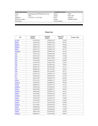
  • 1. Project Information Name: D:Semarang_KAGPSbaseline all.vce Size: 2 MB Modified: 11/18/2015 11:17:08 AM Reference number: Description: Coordinate System Name: UTM Datum: WGS 1984 Zone: 49 South Geoid: EGM96 (Global) Vertical datum: Point List ID Easting (Meter) Northing (Meter) Elevation (Meter) Feature Code 67+000 415399.830 9230639.633 31.022 BM00 352649.299 9238250.194 28.831 BM00A 352682.374 9238247.774 28.850 BM82A 429919.789 9228277.953 29.446 BM89 436412.797 9229907.738 26.770 BM89CP 436445.998 9229929.970 26.812 G01 357367.710 9236837.480 29.276 G02 361911.841 9235986.647 31.448 G03 366598.034 9236137.894 31.239 G04 371818.688 9235944.106 28.988 G05 377835.438 9234551.538 32.821 G06 381994.165 9235439.396 32.685 G07 384659.781 9234978.566 31.211 G08 390446.929 9233515.481 30.021 G09 394400.642 9231103.656 36.131 G16 427556.716 9228978.735 30.070 G17 432782.662 9228593.189 27.744 G18 436412.478 9229907.574 26.246 GPS01 357101.101 9236898.151 30.873 GPS01A 357097.963 9236886.927 30.520 GPS02 362094.973 9235937.375 31.911 GPS02A 362091.406 9235924.467 31.709 GPS03 366919.400 9236045.077 30.014 GPS03A 366885.588 9236053.512 29.631 GPS04 371643.802 9235970.310 29.787 GPS04A 371641.206 9235958.797 29.518 GPS05 376336.165 9234724.755 33.082 GPS05A 376367.486 9234714.174 32.845 GPS06 381119.397 9235635.590 30.808 GPS06A 381158.881 9235652.562 30.675 GPS07 385846.484 9234585.567 31.070 GPS07A 385883.692 9234566.884 31.052 GPS08 390457.846 9233505.435 30.825 GPS08A 390486.767 9233474.968 30.807
  • 2. ID Easting (Meter) Northing (Meter) Elevation (Meter) Feature Code GPS09 394401.604 9231105.411 36.599 GPS09A 394361.735 9231106.192 36.402 GPS10 398233.709 9229163.184 39.385 GPS10A 398235.458 9229150.684 39.179 GPS11 403532.364 9229355.439 41.168 GPS11A 403583.679 9229348.795 41.123 GPS12 408373.370 9229552.653 37.437 GPS12A 408412.661 9229560.453 37.399 GPS13 413339.433 9230346.225 33.073 GPS13A 413299.945 9230340.231 33.225 GPS14 418158.666 9230429.724 31.634 GPS14A 418197.149 9230417.735 31.630 GPS15 423230.766 9229371.036 32.758 GPS15A 423270.261 9229366.124 32.863 GPS16 428002.488 9228839.020 28.273 GPS16A 428044.286 9228826.223 28.204 GPS17 432893.344 9228601.567 27.382 GPS17A 432852.613 9228597.126 28.540 J431A 392339.147 9229259.269 49.768 N1.0259 434778.492 9228005.435 31.290 N1.0263 412361.918 9235509.913 27.774 N1.0264 352378.719 9238268.245 28.477 Date: 11/18/2015 2:37:30 PM Project: D:Semarang_KAGPSbaseline all.vce Trimble Business Center
  • 3. Project Information Name: D:Semarang_KAGPSbaseline all.vce Size: 2 MB Modified: 11/18/2015 11:17:08 AM Reference number: Description: Coordinate System Name: UTM Datum: WGS 1984 Zone: 49 South Geoid: EGM96 (Global) Vertical datum: Baseline Processing Report Processing Summary Observation From To Solution Type H. Prec. (Meter) V. Prec. (Meter) Geodetic Az. Ellipsoid Dist. (Meter) Height (Meter) GPS10 --- GPS10A (B55) GPS10 GPS10A Fixed 0.005 0.010 172°19'56" 12.513 -0.205 GPS11A --- GPS11 (B81) GPS11 GPS11A Fixed 0.005 0.009 97°25'56" 51.684 -0.044 GPS08 --- GPS08A (B78) GPS08 GPS08A Fixed 0.006 0.008 136°36'39" 42.018 -0.016 GPS08 --- GPS09 (B80) GPS08 GPS09 Fixed 0.013 0.025 121°26'36" 4617.790 5.897 GPS07 --- GPS06 (B38) GPS07 GPS06 Fixed 0.007 0.030 282°38'54" 4843.384 -0.374 GPS07 --- GPS05 (B30) GPS07 GPS05 Fixed 0.007 0.033 270°57'47" 9513.432 1.801 GPS05 --- GPS05A (B31) GPS05 GPS05A Fixed 0.005 0.009 108°48'07" 33.067 -0.235 GPS07 --- GPS04 (B49) GPS07 GPS04 Fixed 0.006 0.035 275°41'36" 14273.091 -1.591 GPS04 --- GPS04A (B8) GPS04 GPS04A Fixed 0.007 0.008 192°50'50" 11.805 -0.268 GPS03 --- GPS04 (B17) GPS04 GPS03 Fixed 0.004 0.018 271°02'48" 4725.863 0.115 GPS02 --- GPS04 (B27) GPS04 GPS02 Fixed 0.007 0.029 269°56'32" 9550.569 1.906 GPS02 --- GPS02A (B26) GPS02 GPS02A Fixed 0.006 0.009 195°35'55" 13.394 -0.202 G01 --- GPS04 (B3) G01 GPS04 Fixed 0.007 0.034 93°37'52" 14304.891 0.860 G01 --- GPS01 (B7) G01 GPS01 Fixed 0.004 0.009 282°59'28" 273.356 1.590 G01 --- BM00 (B4) G01 BM00 Fixed 0.007 0.014 286°49'27" 4925.909 -0.587 N1.0264 --- G01 (B2) N1.0264 G01 Fixed 0.014 0.031 106°09'47" 5190.615 0.781 GPS12 --- GPS12A (B75) GPS12 GPS12A Fixed 0.005 0.014 78°46'54" 40.009 -0.037 G07 --- J431A (B132) J431A G07 Fixed 0.016 0.019 306°47'43" 9577.372 -18.857 GPS14 --- N1.0263 (B118) N1.0263 GPS14 Fixed 0.006 0.025 131°19'35" 7710.084 3.944 GPS14 --- GPS14A (B61) GPS14 GPS14A Fixed 0.005 0.008 107°26'13" 40.284 -0.003 GPS14 --- 67+000 (B86) GPS14 67+000 Fixed 0.006 0.009 274°26'27" 2767.667 -0.639 GPS15 --- N1.0263 (B117) N1.0263 GPS15 Fixed 0.008 0.036 119°33'15" 12486.415 5.080 GPS15 --- GPS15A (B57) GPS15 GPS15A Fixed 0.005 0.008 97°14'00" 39.808 0.106 GPS17 --- N1.0259 (B54) N1.0259 GPS17 Fixed 0.004 0.006 287°37'13" 1977.827 -3.913 N1.0259 --- G17 (B108) N1.0259 G17 Fixed 0.005 0.009 286°28'51" 2081.255 -3.554 BM89CP --- N1.0259 (B64) N1.0259 BM89CP Fixed 0.004 0.006 40°58'45" 2547.322 -4.473 N1.0259 --- G18 (B111) N1.0259 G18 Fixed 0.005 0.010 40°44'06" 2508.419 -5.038 J431A --- GPS10 (B93) J431A GPS10 Fixed 0.004 0.019 91°03'13" 5896.950 -10.264 BM89 --- N1.0259 (B84) N1.0259 BM89 Fixed 0.005 0.011 40°44'17" 2508.796 -4.514 N1.0259 --- G16 (B116) N1.0259 G16 Fixed 0.007 0.012 277°44'50" 7289.423 -1.241
  • 4. G16 --- BM82A (B85) G16 BM82A Fixed 0.005 0.013 106°35'52" 2465.611 -0.611 GPS16 --- N1.0259 (B50) N1.0259 GPS16 Fixed 0.008 0.010 277°05'07" 6829.370 -3.039 GPS16 --- GPS16A (B74) GPS16 GPS16A Fixed 0.006 0.010 107°06'08" 43.728 -0.069 G06 --- G05 (B124) G06 G05 Fixed 0.006 0.021 258°04'39" 4253.368 0.061 G06 --- G04 (B125) G06 G04 Fixed 0.010 0.036 272°58'06" 10190.099 -3.923 G06 --- G03 (B126) G06 G03 Fixed 0.014 0.051 272°43'34" 15415.043 -1.789 G06 --- G02 (B127) G06 G02 Fixed 0.011 0.042 271°41'22" 20093.663 -1.703 GPS11 --- GPS12 (B99) GPS11 GPS12 Fixed 0.002 0.012 87°46'24" 4846.413 -3.666 GPS01 --- GPS01A (B20) GPS01 GPS01A Fixed 0.004 0.008 195°46'27" 11.657 -0.353 N1.0263 --- GPS12 (B101) N1.0263 GPS12 Fixed 0.007 0.031 213°53'57" 7171.327 9.622 BM00A --- BM00 (B13) BM00A BM00 Fixed 0.004 0.009 274°20'38" 33.168 -0.020 GPS13A --- GPS13 (B56) GPS13A GPS13 Fixed 0.005 0.014 81°34'10" 39.982 -0.151 GPS03 --- GPS03A (B15) GPS03 GPS03A Fixed 0.005 0.011 284°09'10" 34.854 -0.383 GPS06 --- GPS06A (B36) GPS06 GPS06A Fixed 0.005 0.010 66°52'11" 42.987 -0.132 GPS07 --- GPS07A (B35) GPS07 GPS07A Fixed 0.007 0.012 116°47'14" 41.645 -0.017 GPS09 --- GPS09A (B52) GPS09 GPS09A Fixed 0.005 0.011 271°14'21" 39.887 -0.198 GPS17 --- GPS17A (B70) GPS17 GPS17A Fixed 0.007 0.008 263°51'07" 40.987 1.158 G03 --- G02 (B130) G03 G02 Fixed 0.004 0.018 268°17'48" 4689.417 0.107 G01 --- GPS02 (B28) G01 GPS02 Fixed 0.004 0.017 100°56'06" 4813.018 2.765 G06 --- G07 (B123) G06 G07 Fixed 0.004 0.008 99°56'13" 2705.770 -1.404 G04 --- G03 (B120) G04 G03 Fixed 0.004 0.017 272°15'56" 5225.230 2.126 GPS11 --- GPS10 (B68) GPS11 GPS10 Fixed 0.010 0.018 268°01'39" 5303.604 -1.868 GPS11 --- GPS10 (B91) GPS11 GPS10 Fixed 0.004 0.016 268°01'40" 5303.621 -1.858 GPS15 --- GPS14 (B112) GPS15 GPS14 Fixed 0.004 0.017 281°52'27" 5182.984 -1.160 GPS15 --- GPS14 (B51) GPS15 GPS14 Fixed 0.011 0.016 281°52'28" 5183.012 -1.178 GPS02 --- GPS03 (B23) GPS02 GPS03 Fixed 0.004 0.016 88°52'17" 4826.444 -1.785 GPS10 --- G09 (B92) GPS10 G09 Fixed 0.004 0.022 296°57'46" 4297.418 -3.381 G09 --- G08 (B95) G09 G08 Fixed 0.005 0.023 301°29'58" 4632.439 -6.244 GPS05 --- GPS04 (B48) GPS05 GPS04 Fixed 0.004 0.020 285°00'03" 4855.825 -3.430 G18 --- G17 (B110) G18 G17 Fixed 0.005 0.010 250°09'50" 3861.727 1.488 N1.0263 --- GPS11 (B105) N1.0263 GPS11 Fixed 0.005 0.022 235°13'06" 10765.947 13.370 BM89CP --- GPS17 (B62) BM89CP GPS17 Fixed 0.005 0.007 249°34'06" 3794.177 0.558 GPS07 --- GPS08 (B29) GPS07 GPS08 Fixed 0.006 0.022 103°18'28" 4737.313 -0.136 GPS05 --- GPS06 (B37) GPS05 GPS06 Fixed 0.004 0.020 79°21'13" 4870.223 -2.189 G04 --- G05 (B121) G04 G05 Fixed 0.005 0.019 103°10'17" 6177.073 4.000 GPS16 --- GPS17 (B53) GPS16 GPS17 Fixed 0.005 0.008 92°51'32" 4898.247 -0.873 GPS12 --- GPS13A (B77) GPS12 GPS13A Fixed 0.010 0.032 81°01'00" 4990.528 -4.122 G16 --- G17 (B115) G16 G17 Fixed 0.006 0.011 94°17'56" 5241.835 -2.305 J431A --- G09 (B87) J431A G09 Fixed 0.003 0.018 48°18'07" 2766.838 -13.645 N1.0263 --- GPS13A (B104) N1.0263 GPS13A Fixed 0.007 0.013 169°48'45" 5255.589 5.438 GPS01 --- BM00 (B6) GPS01 BM00 Fixed 0.007 0.014 287°02'58" 4653.219 -2.173 J431A --- GPS11 (B88) J431A GPS11 Fixed 0.005 0.022 89°37'36" 11196.719 -8.399 J431A --- GPS08 (B44) J431A GPS08 Fixed 0.004 0.023 336°13'19" 4645.411 -19.066 G06 --- J431A (B131) J431A G06 Fixed 0.013 0.019 300°58'20" 12053.285 -17.394 GPS07 --- J431A (B45) J431A GPS07 Fixed 0.010 0.037 309°28'55" 8399.874 -18.960 J431A --- GPS12 (B100) J431A GPS12 Fixed 0.008 0.037 89°04'14" 16041.379 -12.059 J431A --- G08 (B96) J431A G08 Fixed 0.005 0.023 336°08'58" 4658.918 -19.887 G04 --- G02 (B129) G04 G02 Fixed 0.006 0.029 270°23'08" 9908.681 2.227
  • 5. G01 --- GPS03 (B18) G01 GPS03 Fixed 0.007 0.029 94°53'51" 9586.122 0.979 GPS10 --- GPS12 (B97) GPS10 GPS12 Fixed 0.006 0.028 87°54'44" 10150.000 -1.796 GPS10 --- G08 (B94) GPS10 G08 Fixed 0.008 0.040 299°18'51" 8922.870 -9.614 N1.0259 --- GPS15 (B113) N1.0259 GPS15 Fixed 0.006 0.030 276°48'57" 11631.899 1.544 GPS16 --- BM89CP (B63) GPS16 BM89CP Fixed 0.008 0.012 82°43'02" 8516.557 -1.430 G18 --- G16 (B114) G18 G16 Fixed 0.008 0.017 264°04'55" 8907.235 3.793 GPS04 --- GPS06 (B46) GPS04 GPS06 Fixed 0.007 0.033 92°09'47" 9483.461 1.247 N1.0263 --- GPS10 (B103) N1.0263 GPS10 Fixed 0.007 0.034 245°54'18" 15492.702 11.487 G03 --- G05 (B122) G03 G05 Fixed 0.008 0.031 98°10'50" 11351.062 1.889 GPS11 --- GPS13A (B89) GPS11 GPS13A Fixed 0.008 0.016 84°20'53" 9819.900 -7.777 N1.0259 --- GPS14 (B109) N1.0259 GPS14 Fixed 0.010 0.044 278°22'14" 16800.985 0.389 G02 --- G05 (B128) G02 G05 Fixed 0.013 0.050 95°18'01" 15991.101 1.798 N1.0263 --- G09 (B106) N1.0263 G09 Fixed 0.016 0.035 256°18'44" 18499.027 8.178 N1.0263 --- G08 (B102) N1.0263 G08 Fixed 0.027 0.074 264°53'44" 22011.607 1.897 Acceptance Summary Processed Passed Flag Fail 92 92 0 0 Date: 11/18/2015 2:43:15 PM Project: D:Semarang_KAGPSbaseline all.vce Trimble Business Center
  • 6. Project Information Name: D:Semarang_KAGPSbaseline all.vce Size: 2 MB Modified: 11/18/2015 11:17:08 AM Reference number: Description: Coordinate System Name: UTM Datum: WGS 1984 Zone: 49 South Geoid: EGM96 (Global) Vertical datum: Baseline Processing Report Session Details GPS10 - GPS10A (3:19:15 PM-3:47:05 PM) (S55) Baseline Observation: GPS10 --- GPS10A (B55) Processed: 11/18/2015 8:32:44 AM Solution Type: Fixed Frequency used: L1 only Horizontal Precision: 0.005 m Vertical Precision: 0.010 m RMS: 0.006 m Ratio: 33.615 Maximum PDOP: 1.978 Ephemeris used: Broadcast Antenna Model: No phase table corrections applied. Processing Start Time: 12/18/2015 3:19:15 PM (Local: UTC+7hr) Processing Stop Time: 12/18/2015 3:47:05 PM (Local: UTC+7hr) Processing Duration: 00:27:50 Vector Components (Mark to Mark)
  • 7. From: GPS10 Grid Local Global Easting 398233.709 m Latitude S6°58’21.93294” Latitude S6°58’21.93294” Northing 9229163.184 m Longitude E110°04’43.39872” Longitude E110°04’43.39872” Elevation 21.238 m Height 45.683 m Height 45.683 m To: GPS10A Grid Local Global Easting 398233.077 m Latitude S6°58'22.36415" Latitude S6°58'22.36415" Northing 9229149.940 m Longitude E110°04'43.37727" Longitude E110°04'43.37727" Elevation 21.033 m Height 45.478 m Height 45.478 m Vector: Easting 1.693 m NS Fwd Azimuth 172°19'56" X -0.981 m Northing -12.394 m Ellipsoid Dist. 12.513 Y -2.178 m Elevation -0.206 m Height -0.205 Z -12.284 m Standard Errors Vector Errors: Easting 0.002 m  NS Fwd Azimuth 0°00'31" X 0.003 m Northing 0.002 m  Ellipsoid Dist. 0.002 m Y 0.005 m Elevation 0.005 m Height 0.005 m Z 0.002 m Aposteriori Covariance Matrix (Meter2 ) X Y Z X 0.0000075471 Y -0.0000088269 0.0000219193 Z 0.0000002631 0.0000001092 0.0000044696
  • 8. Occupations From To Point ID: GPS10 GPS10A Data File: D:Semarang_KAGPSbaseline all486635288.15O D:Semarang_KAGPSbaseline allG10A3522.15O Receiver Type: Geo Explorer 3 Geo Explorer 3 Receiver Serial Number: Antenna Type: Unknown External Unknown External Antenna Serial Number: -------- -------- Antenna Height (Measured): 1.004 m 1.164 m Antenna Method: Bottom of antenna mount Bottom of antenna mount Tracking Summary Processing Style Elevation Mask: 10.0 deg Auto Start Processing: Yes Start Automatic ID Numbering: AUTO0001 Continuous Vectors: No Generate Residuals: Yes Antenna Model: Automatic Ephemeris Type: Automatic Frequency: Multiple Frequencies Force Float: No
  • 9. Acceptance Criteria Vector Component Flag Fail Horizontal Precision > 0.050 m + 1.000 ppm 0.100 m + 1.000 ppm Vertical Precision > 0.100 m + 1.000 ppm 0.200 m + 1.000 ppm Date: 11/18/2015 2:43:14 PM Project: D:Semarang_KAGPSbaseline all.vce Trimble Business Center
  • 10. Project Information Name: D:Semarang_KAGPSbaseline all.vce Size: 2 MB Modified: 11/18/2015 11:17:08 AM Reference number: Description: Coordinate System Name: UTM Datum: WGS 1984 Zone: 49 South Geoid: EGM96 (Global) Vertical datum: Baseline Processing Report Session Details GPS11A - GPS11 (3:06:40 PM-3:40:35 PM) (S81) Baseline Observation: GPS11A --- GPS11 (B81) Processed: 11/18/2015 8:32:47 AM Solution Type: Fixed Frequency used: L1 only Horizontal Precision: 0.005 m Vertical Precision: 0.009 m RMS: 0.008 m Ratio: 43.677 Maximum PDOP: 1.979 Ephemeris used: Broadcast Antenna Model: No phase table corrections applied. Processing Start Time: 12/18/2015 3:06:40 PM (Local: UTC+7hr) Processing Stop Time: 12/18/2015 3:40:35 PM (Local: UTC+7hr) Processing Duration: 00:33:55 Vector Components (Mark to Mark)
  • 11. From: GPS11 Grid Local Global Easting 403532.364 m Latitude S6°58’16.00082” Latitude S6°58’16.00082” Northing 9229355.439 m Longitude E110°07’36.08140” Longitude E110°07’36.08140” Elevation 27.449 m Height 51.963 m Height 51.963 m To: GPS11A Grid Local Global Easting 403584.335 m Latitude S6°58'16.26943" Latitude S6°58'16.26943" Northing 9229347.287 m Longitude E110°07'37.77453" Longitude E110°07'37.77453" Elevation 27.403 m Height 51.919 m Height 51.919 m Vector: Easting 51.248 m NS Fwd Azimuth 97°25'56" X -47.826 m Northing -6.589 m Ellipsoid Dist. 51.684 Y -18.438 m Elevation -0.045 m Height -0.044 Z -6.631 m Standard Errors Vector Errors: Easting 0.002 m  NS Fwd Azimuth 0°00'08" X 0.003 m Northing 0.002 m  Ellipsoid Dist. 0.002 m Y 0.004 m Elevation 0.005 m Height 0.005 m Z 0.002 m Aposteriori Covariance Matrix (Meter2 ) X Y Z X 0.0000064174 Y -0.0000074062 0.0000182109 Z 0.0000000678 0.0000001106 0.0000036800
  • 12. Occupations From To Point ID: GPS11 GPS11A Data File: D:Semarang_KAGPSbaseline all27063524.15O D:Semarang_KAGPSbaseline all27713524.15O Receiver Type: Geo Explorer 3 Geo Explorer 3 Receiver Serial Number: Antenna Type: Unknown External Unknown External Antenna Serial Number: -------- -------- Antenna Height (Measured): 1.096 m 1.139 m Antenna Method: Bottom of antenna mount Bottom of antenna mount Tracking Summary Processing Style Elevation Mask: 10.0 deg Auto Start Processing: Yes Start Automatic ID Numbering: AUTO0001 Continuous Vectors: No Generate Residuals: Yes Antenna Model: Automatic Ephemeris Type: Automatic Frequency: Multiple Frequencies Force Float: No
  • 13. Acceptance Criteria Vector Component Flag Fail Horizontal Precision > 0.050 m + 1.000 ppm 0.100 m + 1.000 ppm Vertical Precision > 0.100 m + 1.000 ppm 0.200 m + 1.000 ppm Date: 11/18/2015 2:43:14 PM Project: D:Semarang_KAGPSbaseline all.vce Trimble Business Center
  • 14. Project Information Name: D:Semarang_KAGPSbaseline all.vce Size: 2 MB Modified: 11/18/2015 11:17:08 AM Reference number: Description: Coordinate System Name: UTM Datum: WGS 1984 Zone: 49 South Geoid: EGM96 (Global) Vertical datum: Baseline Processing Report Session Details GPS08 - GPS08A (5:07:10 PM-5:41:15 PM) (S78) Baseline Observation: GPS08 --- GPS08A (B78) Processed: 11/18/2015 8:32:48 AM Solution Type: Fixed Frequency used: L1 only Horizontal Precision: 0.006 m Vertical Precision: 0.008 m RMS: 0.006 m Ratio: 15.838 Maximum PDOP: 2.307 Ephemeris used: Broadcast Antenna Model: No phase table corrections applied. Processing Start Time: 12/18/2015 5:07:10 PM (Local: UTC+7hr) Processing Stop Time: 12/18/2015 5:41:15 PM (Local: UTC+7hr) Processing Duration: 00:34:05 Vector Components (Mark to Mark)
  • 15. From: GPS08 Grid Local Global Easting 390455.920 m Latitude S6°55'59.93292" Latitude S6°55'59.93292" Northing 9233508.516 m Longitude E110°00'30.23928" Longitude E110°00'30.23928" Elevation 12.506 m Height 36.725 m Height 36.725 m To: GPS08A Grid Local Global Easting 390484.841 m Latitude S6°56'00.92691" Latitude S6°56'00.92691" Northing 9233478.049 m Longitude E110°00'31.17957" Longitude E110°00'31.17957" Elevation 12.489 m Height 36.709 m Height 36.709 m Vector: Easting 28.921 m NS Fwd Azimuth 136°36'39" X -25.856 m Northing -30.467 m Ellipsoid Dist. 42.018 Y -13.355 m Elevation -0.018 m Height -0.016 Z -30.310 m Standard Errors Vector Errors: Easting 0.002 m  NS Fwd Azimuth 0°00'10" X 0.002 m Northing 0.002 m  Ellipsoid Dist. 0.002 m Y 0.004 m Elevation 0.004 m Height 0.004 m Z 0.002 m Aposteriori Covariance Matrix (Meter2 ) X Y Z X 0.0000061349 Y -0.0000032761 0.0000149171 Z 0.0000006657 -0.0000021705 0.0000026241
  • 16. Occupations From To Point ID: GPS08 GPS08A Data File: D:Semarang_KAGPSbaseline all27713525.15O D:Semarang_KAGPSbaseline all27063525.15O Receiver Type: Geo Explorer 3 Geo Explorer 3 Receiver Serial Number: Antenna Type: Unknown External Unknown External Antenna Serial Number: -------- -------- Antenna Height (Measured): 1.068 m 1.130 m Antenna Method: Bottom of antenna mount Bottom of antenna mount Tracking Summary Processing Style Elevation Mask: 10.0 deg Auto Start Processing: Yes Start Automatic ID Numbering: AUTO0001 Continuous Vectors: No Generate Residuals: Yes Antenna Model: Automatic Ephemeris Type: Automatic Frequency: Multiple Frequencies Force Float: No
  • 17. Acceptance Criteria Vector Component Flag Fail Horizontal Precision > 0.050 m + 1.000 ppm 0.100 m + 1.000 ppm Vertical Precision > 0.100 m + 1.000 ppm 0.200 m + 1.000 ppm Date: 11/18/2015 2:43:14 PM Project: D:Semarang_KAGPSbaseline all.vce Trimble Business Center
  • 18. Project Information Name: D:Semarang_KAGPSbaseline all.vce Size: 2 MB Modified: 11/18/2015 11:17:08 AM Reference number: Description: Coordinate System Name: UTM Datum: WGS 1984 Zone: 49 South Geoid: EGM96 (Global) Vertical datum: Baseline Processing Report Session Details GPS08 - GPS09 (4:57:50 PM-5:06:35 PM) (S80) Baseline Observation: GPS08 --- GPS09 (B80) Processed: 11/18/2015 10:39:37 AM Solution Type: Fixed Frequency used: L1 only Horizontal Precision: 0.013 m Vertical Precision: 0.025 m RMS: 0.011 m Ratio: 4.319 Maximum PDOP: 1.807 Ephemeris used: Broadcast Antenna Model: No phase table corrections applied. Processing Start Time: 12/18/2015 4:57:50 PM (Local: UTC+7hr) Processing Stop Time: 12/18/2015 5:06:35 PM (Local: UTC+7hr) Processing Duration: 00:08:45 Vector Components (Mark to Mark)
  • 19. From: GPS08 Grid Local Global Easting 390457.002 m Latitude S6°56'00.08878" Latitude S6°56'00.08878" Northing 9233503.732 m Longitude E110°00'30.27422" Longitude E110°00'30.27422" Elevation 30.409 m Height 54.628 m Height 54.628 m To: GPS09 Grid Local Global Easting 394400.725 m Latitude S6°57'18.49922" Latitude S6°57'18.49922" Northing 9231103.713 m Longitude E110°02'38.61987" Longitude E110°02'38.61987" Elevation 36.184 m Height 60.526 m Height 60.526 m Vector: Easting 3943.723 m NS Fwd Azimuth 121°26'36" X -3603.885 m Northing -2400.019 m Ellipsoid Dist. 4617.790 Y -1617.314 m Elevation 5.775 m Height 5.897 Z -2391.801 m Standard Errors Vector Errors: Easting 0.005 m  NS Fwd Azimuth 0°00'00" X 0.007 m Northing 0.004 m  Ellipsoid Dist. 0.005 m Y 0.012 m Elevation 0.013 m Height 0.013 m Z 0.004 m Aposteriori Covariance Matrix (Meter2 ) X Y Z X 0.0000423981 Y -0.0000398771 0.0001449353 Z 0.0000073547 -0.0000249691 0.0000187008
  • 20. Occupations From To Point ID: GPS08 GPS09 Data File: D:Semarang_KAGPSbaseline all27713525.15O D:Semarang_KAGPSbaseline all48663529F.15O Receiver Type: Geo Explorer 3 Geo Explorer 3 Receiver Serial Number: Antenna Type: Unknown External Unknown External Antenna Serial Number: -------- -------- Antenna Height (Measured): 1.068 m 1.018 m Antenna Method: Bottom of antenna mount Bottom of antenna mount Tracking Summary Processing Style Elevation Mask: 10.0 deg Auto Start Processing: Yes Start Automatic ID Numbering: AUTO0001 Continuous Vectors: No Generate Residuals: Yes Antenna Model: Automatic Ephemeris Type: Automatic Frequency: Multiple Frequencies Force Float: No
  • 21. Acceptance Criteria Vector Component Flag Fail Horizontal Precision > 0.050 m + 1.000 ppm 0.100 m + 1.000 ppm Vertical Precision > 0.100 m + 1.000 ppm 0.200 m + 1.000 ppm Date: 11/18/2015 2:43:14 PM Project: D:Semarang_KAGPSbaseline all.vce Trimble Business Center
  • 22. Project Information Name: D:Semarang_KAGPSbaseline all.vce Size: 2 MB Modified: 11/18/2015 11:17:08 AM Reference number: Description: Coordinate System Name: UTM Datum: WGS 1984 Zone: 49 South Geoid: EGM96 (Global) Vertical datum: Baseline Processing Report Session Details GPS07 - GPS06 (2:33:20 PM-4:33:20 PM) (S38) Baseline Observation: GPS07 --- GPS06 (B38) Processed: 11/18/2015 10:23:54 AM Solution Type: Fixed Frequency used: L1 only Horizontal Precision: 0.007 m Vertical Precision: 0.030 m RMS: 0.010 m Ratio: 7.087 Maximum PDOP: 14.906 Ephemeris used: Broadcast Antenna Model: No phase table corrections applied. Processing Start Time: 12/19/2015 2:33:20 PM (Local: UTC+7hr) Processing Stop Time: 12/19/2015 4:33:20 PM (Local: UTC+7hr) Processing Duration: 02:00:00
  • 23. Vector Components (Mark to Mark) From: GPS07 Grid Local Global Easting 385846.121 m Latitude S6°55'24.56927" Latitude S6°55'24.56927" Northing 9234584.781 m Longitude E109°58'00.11037" Longitude E109°58'00.11037" Elevation 30.543 m Height 54.649 m Height 54.649 m To: GPS06 Grid Local Global Easting 381119.078 m Latitude S6°54'50.03908" Latitude S6°54'50.03908" Northing 9235634.807 m Longitude E109°55'26.16752" Longitude E109°55'26.16752" Elevation 30.292 m Height 54.275 m Height 54.275 m Vector: Easting -4727.043 m NS Fwd Azimuth 282°38'54" X 4398.915 m Northing 1050.026 m Ellipsoid Dist. 4843.384 Y 1731.860 m Elevation -0.251 m Height -0.374 Z 1053.082 m Standard Errors Vector Errors: Easting 0.003 m  NS Fwd Azimuth 0°00'00" X 0.007 m Northing 0.002 m  Ellipsoid Dist. 0.002 m Y 0.014 m Elevation 0.015 m Height 0.015 m Z 0.003 m Aposteriori Covariance Matrix (Meter2 ) X Y Z X 0.0000478791 Y -0.0000888205 0.0001848242
  • 24. Z 0.0000073359 -0.0000167491 0.0000065415 Occupations From To Point ID: GPS07 GPS06 Data File: D:Semarang_KAGPSbaseline all48733533P.15O D:Semarang_KAGPSbaseline allGP603532.15O Receiver Type: Geo Explorer 3 Geo Explorer 3 Receiver Serial Number: Antenna Type: Unknown External Unknown External Antenna Serial Number: -------- -------- Antenna Height (Measured): 1.066 m 1.135 m Antenna Method: Bottom of antenna mount Bottom of antenna mount Tracking Summary Processing Style Elevation Mask: 10.0 deg Auto Start Processing: Yes Start Automatic ID Numbering: AUTO0001 Continuous Vectors: No Generate Residuals: Yes Antenna Model: Automatic Ephemeris Type: Automatic Frequency: Multiple Frequencies Force Float: No
  • 25. Acceptance Criteria Vector Component Flag Fail Horizontal Precision > 0.050 m + 1.000 ppm 0.100 m + 1.000 ppm Vertical Precision > 0.100 m + 1.000 ppm 0.200 m + 1.000 ppm Date: 11/18/2015 2:43:14 PM Project: D:Semarang_KAGPSbaseline all.vce Trimble Business Center Project Information Name: D:Semarang_KAGPSbaseline all.vce Size: 2 MB Modified: 11/18/2015 11:17:08 AM Reference number: Description: Coordinate System Name: UTM Datum: WGS 1984 Zone: 49 South Geoid: EGM96 (Global) Vertical datum:
  • 26. Baseline Processing Report Session Details GPS07 - GPS05 (2:17:35 PM-4:39:55 PM) (S30) Baseline Observation: GPS07 --- GPS05 (B30) Processed: 11/18/2015 8:32:53 AM Solution Type: Fixed Frequency used: L1 only Horizontal Precision: 0.007 m Vertical Precision: 0.033 m RMS: 0.019 m Ratio: 2.457 Maximum PDOP: 9.438 Ephemeris used: Broadcast Antenna Model: No phase table corrections applied. Processing Start Time: 12/19/2015 2:17:35 PM (Local: UTC+7hr) Processing Stop Time: 12/19/2015 4:39:55 PM (Local: UTC+7hr) Processing Duration: 02:22:20 Vector Components (Mark to Mark) From: GPS07 Grid Local Global Easting 385846.335 m Latitude S6°55'24.50874" Latitude S6°55'24.50874" Northing 9234586.641 m Longitude E109°58'00.11747" Longitude E109°58'00.11747" Elevation 8.254 m Height 32.360 m Height 32.360 m
  • 27. To: GPS05 Grid Local Global Easting 376336.062 m Latitude S6°55'19.27499" Latitude S6°55'19.27499" Northing 9234725.847 m Longitude E109°52'50.25917" Longitude E109°52'50.25917" Elevation 10.264 m Height 34.161 m Height 34.161 m Vector: Easting -9510.273 m NS Fwd Azimuth 270°57'47" X 8935.584 m Northing 139.207 m Ellipsoid Dist. 9513.432 Y 3261.325 m Elevation 2.010 m Height 1.801 Z 159.390 m Standard Errors Vector Errors: Easting 0.003 m  NS Fwd Azimuth 0°00'00" X 0.007 m Northing 0.003 m  Ellipsoid Dist. 0.003 m Y 0.015 m Elevation 0.017 m Height 0.017 m Z 0.003 m Aposteriori Covariance Matrix (Meter2 ) X Y Z X 0.0000467350 Y -0.0000969548 0.0002394623 Z 0.0000128060 -0.0000322851 0.0000111423 Occupations From To Point ID: GPS07 GPS05 Data File: D:Semarang_KAGPSbaseline all48733533P.15O D:Semarang_KAGPSbaseline all27203532.15O
  • 28. Receiver Type: Geo Explorer 3 Geo Explorer 3 Receiver Serial Number: Antenna Type: Unknown External Unknown External Antenna Serial Number: -------- -------- Antenna Height (Measured): 1.066 m 1.203 m Antenna Method: Bottom of antenna mount Bottom of antenna mount Tracking Summary Processing Style Elevation Mask: 10.0 deg Auto Start Processing: Yes Start Automatic ID Numbering: AUTO0001 Continuous Vectors: No Generate Residuals: Yes Antenna Model: Automatic Ephemeris Type: Automatic Frequency: Multiple Frequencies Force Float: No Acceptance Criteria Vector Component Flag Fail Horizontal Precision > 0.050 m + 1.000 ppm 0.100 m + 1.000 ppm Vertical Precision > 0.100 m + 1.000 ppm 0.200 m + 1.000 ppm
  • 29. Date: 11/18/2015 2:43:14 PM Project: D:Semarang_KAGPSbaseline all.vce Trimble Business Center
  • 30. Project Information Name: D:Semarang_KAGPSbaseline all.vce Size: 2 MB Modified: 11/18/2015 11:17:08 AM Reference number: Description: Coordinate System Name: UTM Datum: WGS 1984 Zone: 49 South Geoid: EGM96 (Global) Vertical datum: Baseline Processing Report Session Details GPS05 - GPS05A (4:50:10 PM-5:23:45 PM) (S31) Baseline Observation: GPS05 --- GPS05A (B31) Processed: 11/18/2015 8:32:53 AM Solution Type: Fixed Frequency used: L1 only Horizontal Precision: 0.005 m Vertical Precision: 0.009 m RMS: 0.005 m Ratio: 19.077 Maximum PDOP: 3.310 Ephemeris used: Broadcast Antenna Model: No phase table corrections applied. Processing Start Time: 12/19/2015 4:50:10 PM (Local: UTC+7hr) Processing Stop Time: 12/19/2015 5:23:45 PM (Local: UTC+7hr) Processing Duration: 00:33:35
  • 31. Vector Components (Mark to Mark) From: GPS05 Grid Local Global Easting 376336.062 m Latitude S6°55'19.27499" Latitude S6°55'19.27499" Northing 9234725.847 m Longitude E109°52'50.25917" Longitude E109°52'50.25917" Elevation 10.264 m Height 34.161 m Height 34.161 m To: GPS05A Grid Local Global Easting 376367.383 m Latitude S6°55'19.62191" Latitude S6°55'19.62191" Northing 9234715.266 m Longitude E109°52'51.27885" Longitude E109°52'51.27885" Elevation 10.028 m Height 33.925 m Height 33.925 m Vector: Easting 31.321 m NS Fwd Azimuth 108°48'07" X -28.921 m Northing -10.581 m Ellipsoid Dist. 33.067 Y -12.073 m Elevation -0.236 m Height -0.235 Z -10.551 m Standard Errors Vector Errors: Easting 0.002 m  NS Fwd Azimuth 0°00'10" X 0.002 m Northing 0.001 m  Ellipsoid Dist. 0.002 m Y 0.004 m Elevation 0.004 m Height 0.004 m Z 0.002 m Aposteriori Covariance Matrix (Meter2 ) X Y Z X 0.0000058181 Y -0.0000042160 0.0000172224
  • 32. Z 0.0000009799 -0.0000029254 0.0000025728 Occupations From To Point ID: GPS05 GPS05A Data File: D:Semarang_KAGPSbaseline all27203532.15O D:Semarang_KAGPSbaseline allGP5A3533.15O Receiver Type: Geo Explorer 3 Geo Explorer 3 Receiver Serial Number: Antenna Type: Unknown External Unknown External Antenna Serial Number: -------- -------- Antenna Height (Measured): 1.203 m 0.871 m Antenna Method: Bottom of antenna mount Bottom of antenna mount Tracking Summary Processing Style Elevation Mask: 10.0 deg Auto Start Processing: Yes Start Automatic ID Numbering: AUTO0001 Continuous Vectors: No Generate Residuals: Yes Antenna Model: Automatic Ephemeris Type: Automatic Frequency: Multiple Frequencies Force Float: No
  • 33. Acceptance Criteria Vector Component Flag Fail Horizontal Precision > 0.050 m + 1.000 ppm 0.100 m + 1.000 ppm Vertical Precision > 0.100 m + 1.000 ppm 0.200 m + 1.000 ppm Date: 11/18/2015 2:43:14 PM Project: D:Semarang_KAGPSbaseline all.vce Trimble Business Center
  • 34. Project Information Name: D:Semarang_KAGPSbaseline all.vce Size: 2 MB Modified: 11/18/2015 11:17:08 AM Reference number: Description: Coordinate System Name: UTM Datum: WGS 1984 Zone: 49 South Geoid: EGM96 (Global) Vertical datum: Baseline Processing Report Session Details GPS04 - GPS04A (10:00:55 AM-10:30:55 AM) (S8) Baseline Observation: GPS04 --- GPS04A (B8) Processed: 11/18/2015 8:32:56 AM Solution Type: Fixed Frequency used: L1 only Horizontal Precision: 0.007 m Vertical Precision: 0.008 m RMS: 0.005 m Ratio: 145.760 Maximum PDOP: 3.359 Ephemeris used: Broadcast Antenna Model: No phase table corrections applied. Processing Start Time: 12/20/2015 10:00:55 AM (Local: UTC+7hr) Processing Stop Time: 12/20/2015 10:30:55 AM (Local: UTC+7hr) Processing Duration: 00:30:00 Vector Components (Mark to Mark)
  • 35. From: GPS04 Grid Local Global Easting 371643.703 m Latitude S6°54'38.35391" Latitude S6°54'38.35391" Northing 9235971.422 m Longitude E109°50'17.47303" Longitude E109°50'17.47303" Elevation 7.138 m Height 30.898 m Height 30.898 m To: GPS04A Grid Local Global Easting 371641.107 m Latitude S6°54'38.72856" Latitude S6°54'38.72856" Northing 9235959.909 m Longitude E109°50'17.38753" Longitude E109°50'17.38753" Elevation 6.870 m Height 30.630 m Height 30.630 m Vector: Easting -2.596 m NS Fwd Azimuth 192°50'50" X 3.029 m Northing -11.513 m Ellipsoid Dist. 11.805 Y -0.663 m Elevation -0.269 m Height -0.268 Z -11.393 m Standard Errors Vector Errors: Easting 0.002 m  NS Fwd Azimuth 0°00'46" X 0.003 m Northing 0.002 m  Ellipsoid Dist. 0.002 m Y 0.004 m Elevation 0.004 m Height 0.004 m Z 0.002 m Aposteriori Covariance Matrix (Meter2 ) X Y Z X 0.0000069245 Y -0.0000031618 0.0000149739 Z 0.0000030177 -0.0000005995 0.0000056396
  • 36. Occupations From To Point ID: GPS04 GPS04A Data File: D:Semarang_KAGPSbaseline all486635430.15O D:Semarang_KAGPSbaseline allGP4A354B.15O Receiver Type: Geo Explorer 3 Geo Explorer 3 Receiver Serial Number: Antenna Type: Unknown External Unknown External Antenna Serial Number: -------- -------- Antenna Height (Measured): 0.742 m 1.043 m Antenna Method: Bottom of antenna mount Bottom of antenna mount Tracking Summary Processing Style Elevation Mask: 10.0 deg Auto Start Processing: Yes Start Automatic ID Numbering: AUTO0001 Continuous Vectors: No Generate Residuals: Yes Antenna Model: Automatic Ephemeris Type: Automatic Frequency: Multiple Frequencies Force Float: No
  • 37. Acceptance Criteria Vector Component Flag Fail Horizontal Precision > 0.050 m + 1.000 ppm 0.100 m + 1.000 ppm Vertical Precision > 0.100 m + 1.000 ppm 0.200 m + 1.000 ppm Date: 11/18/2015 2:43:14 PM Project: D:Semarang_KAGPSbaseline all.vce Trimble Business Center
  • 38. Project Information Name: D:Semarang_KAGPSbaseline all.vce Size: 2 MB Modified: 11/18/2015 11:17:08 AM Reference number: Description: Coordinate System Name: UTM Datum: WGS 1984 Zone: 49 South Geoid: EGM96 (Global) Vertical datum: Baseline Processing Report Session Details GPS03 - GPS04 (10:00:55 AM-12:31:40 PM) (S17) Baseline Observation: GPS03 --- GPS04 (B17) Processed: 11/18/2015 8:32:58 AM Solution Type: Fixed Frequency used: L1 only Horizontal Precision: 0.004 m Vertical Precision: 0.018 m RMS: 0.010 m Ratio: 8.923 Maximum PDOP: 6.940 Ephemeris used: Broadcast Antenna Model: No phase table corrections applied. Processing Start Time: 12/20/2015 10:00:55 AM (Local: UTC+7hr) Processing Stop Time: 12/20/2015 12:31:40 PM (Local: UTC+7hr) Processing Duration: 02:30:45 Vector Components (Mark to Mark)
  • 39. From: GPS04 Grid Local Global Easting 371643.703 m Latitude S6°54'38.35391" Latitude S6°54'38.35391" Northing 9235971.422 m Longitude E109°50'17.47303" Longitude E109°50'17.47303" Elevation 7.138 m Height 30.898 m Height 30.898 m To: GPS03 Grid Local Global Easting 366919.323 m Latitude S6°54'35.53702" Latitude S6°54'35.53702" Northing 9236046.200 m Longitude E109°47'43.55665" Longitude E109°47'43.55665" Elevation 7.366 m Height 31.013 m Height 31.013 m Vector: Easting -4724.380 m NS Fwd Azimuth 271°02'48" X 4441.711 m Northing 74.778 m Ellipsoid Dist. 4725.863 Y 1611.774 m Elevation 0.228 m Height 0.115 Z 85.891 m Standard Errors Vector Errors: Easting 0.002 m  NS Fwd Azimuth 0°00'00" X 0.003 m Northing 0.001 m  Ellipsoid Dist. 0.002 m Y 0.008 m Elevation 0.009 m Height 0.009 m Z 0.002 m Aposteriori Covariance Matrix (Meter2 ) X Y Z X 0.0000120411 Y -0.0000250963 0.0000704396 Z 0.0000038359 -0.0000100844 0.0000034815
  • 40. Occupations From To Point ID: GPS04 GPS03 Data File: D:Semarang_KAGPSbaseline all486635430.15O D:Semarang_KAGPSbaseline allGPS33541.15O Receiver Type: Geo Explorer 3 Geo Explorer 3 Receiver Serial Number: Antenna Type: Unknown External Unknown External Antenna Serial Number: -------- -------- Antenna Height (Measured): 0.742 m 1.064 m Antenna Method: Bottom of antenna mount Bottom of antenna mount Tracking Summary Processing Style Elevation Mask: 10.0 deg Auto Start Processing: Yes Start Automatic ID Numbering: AUTO0001 Continuous Vectors: No Generate Residuals: Yes Antenna Model: Automatic Ephemeris Type: Automatic Frequency: Multiple Frequencies Force Float: No
  • 41. Acceptance Criteria Vector Component Flag Fail Horizontal Precision > 0.050 m + 1.000 ppm 0.100 m + 1.000 ppm Vertical Precision > 0.100 m + 1.000 ppm 0.200 m + 1.000 ppm Date: 11/18/2015 2:43:14 PM Project: D:Semarang_KAGPSbaseline all.vce Trimble Business Center
  • 42. Project Information Name: D:Semarang_KAGPSbaseline all.vce Size: 2 MB Modified: 11/18/2015 11:17:08 AM Reference number: Description: Coordinate System Name: UTM Datum: WGS 1984 Zone: 49 South Geoid: EGM96 (Global) Vertical datum: Baseline Processing Report Session Details GPS02 - GPS04 (10:00:55 AM-12:32:05 PM) (S27) Baseline Observation: GPS02 --- GPS04 (B27) Processed: 11/18/2015 8:33:00 AM Solution Type: Fixed Frequency used: L1 only Horizontal Precision: 0.007 m Vertical Precision: 0.029 m RMS: 0.013 m Ratio: 4.616 Maximum PDOP: 9.156 Ephemeris used: Broadcast Antenna Model: No phase table corrections applied. Processing Start Time: 12/20/2015 10:00:55 AM (Local: UTC+7hr) Processing Stop Time: 12/20/2015 12:32:05 PM (Local: UTC+7hr) Processing Duration: 02:31:10 Vector Components (Mark to Mark)
  • 43. From: GPS04 Grid Local Global Easting 371643.703 m Latitude S6°54'38.35391" Latitude S6°54'38.35391" Northing 9235971.422 m Longitude E109°50'17.47303" Longitude E109°50'17.47303" Elevation 7.138 m Height 30.898 m Height 30.898 m To: GPS02 Grid Local Global Easting 362094.916 m Latitude S6°54'38.63861" Latitude S6°54'38.63861" Northing 9235938.511 m Longitude E109°45'06.36873" Longitude E109°45'06.36873" Elevation 9.269 m Height 32.805 m Height 32.805 m Vector: Easting -9548.788 m NS Fwd Azimuth 269°56'32" X 8985.986 m Northing -32.912 m Ellipsoid Dist. 9550.569 Y 3235.157 m Elevation 2.131 m Height 1.906 Z -8.912 m Standard Errors Vector Errors: Easting 0.003 m  NS Fwd Azimuth 0°00'00" X 0.006 m Northing 0.002 m  Ellipsoid Dist. 0.003 m Y 0.014 m Elevation 0.015 m Height 0.015 m Z 0.003 m Aposteriori Covariance Matrix (Meter2 ) X Y Z X 0.0000328324 Y -0.0000676805 0.0001907978 Z 0.0000103678 -0.0000272703 0.0000096832
  • 44. Occupations From To Point ID: GPS04 GPS02 Data File: D:Semarang_KAGPSbaseline all486635430.15O D:Semarang_KAGPSbaseline allGP203541.15O Receiver Type: Geo Explorer 3 Geo Explorer 3 Receiver Serial Number: Antenna Type: Unknown External Unknown External Antenna Serial Number: -------- -------- Antenna Height (Measured): 0.742 m 0.965 m Antenna Method: Bottom of antenna mount Bottom of antenna mount Tracking Summary Processing Style Elevation Mask: 10.0 deg Auto Start Processing: Yes Start Automatic ID Numbering: AUTO0001 Continuous Vectors: No Generate Residuals: Yes Antenna Model: Automatic Ephemeris Type: Automatic Frequency: Multiple Frequencies Force Float: No
  • 45. Acceptance Criteria Vector Component Flag Fail Horizontal Precision > 0.050 m + 1.000 ppm 0.100 m + 1.000 ppm Vertical Precision > 0.100 m + 1.000 ppm 0.200 m + 1.000 ppm Date: 11/18/2015 2:43:14 PM Project: D:Semarang_KAGPSbaseline all.vce Trimble Business Center
  • 46. Project Information Name: D:Semarang_KAGPSbaseline all.vce Size: 2 MB Modified: 11/18/2015 11:17:08 AM Reference number: Description: Coordinate System Name: UTM Datum: WGS 1984 Zone: 49 South Geoid: EGM96 (Global) Vertical datum: Baseline Processing Report Session Details GPS02 - GPS02A (12:32:25 PM-1:01:20 PM) (S26) Baseline Observation: GPS02 --- GPS02A (B26) Processed: 11/18/2015 8:33:00 AM Solution Type: Fixed Frequency used: L1 only Horizontal Precision: 0.006 m Vertical Precision: 0.009 m RMS: 0.005 m Ratio: 339.599 Maximum PDOP: 6.156 Ephemeris used: Broadcast Antenna Model: No phase table corrections applied. Processing Start Time: 12/20/2015 12:32:25 PM (Local: UTC+7hr) Processing Stop Time: 12/20/2015 1:01:20 PM (Local: UTC+7hr) Processing Duration: 00:28:55 Vector Components (Mark to Mark)
  • 47. From: GPS02 Grid Local Global Easting 362094.916 m Latitude S6°54'38.63861" Latitude S6°54'38.63861" Northing 9235938.511 m Longitude E109°45'06.36873" Longitude E109°45'06.36873" Elevation 9.269 m Height 32.805 m Height 32.805 m To: GPS02A Grid Local Global Easting 362091.348 m Latitude S6°54'39.05856" Latitude S6°54'39.05856" Northing 9235925.602 m Longitude E109°45'06.25141" Longitude E109°45'06.25141" Elevation 9.067 m Height 32.603 m Height 32.603 m Vector: Easting -3.567 m NS Fwd Azimuth 195°35'55" X 3.982 m Northing -12.908 m Ellipsoid Dist. 13.394 Y -0.432 m Elevation -0.202 m Height -0.202 Z -12.783 m Standard Errors Vector Errors: Easting 0.002 m  NS Fwd Azimuth 0°00'35" X 0.002 m Northing 0.002 m  Ellipsoid Dist. 0.002 m Y 0.004 m Elevation 0.004 m Height 0.004 m Z 0.002 m Aposteriori Covariance Matrix (Meter2 ) X Y Z X 0.0000061216 Y -0.0000036462 0.0000177151 Z 0.0000009587 -0.0000021870 0.0000045493
  • 48. Occupations From To Point ID: GPS02 GPS02A Data File: D:Semarang_KAGPSbaseline allGP203541.15O D:Semarang_KAGPSbaseline allGP2A3543.15O Receiver Type: Geo Explorer 3 Geo Explorer 3 Receiver Serial Number: Antenna Type: Unknown External Unknown External Antenna Serial Number: -------- -------- Antenna Height (Measured): 0.965 m 1.036 m Antenna Method: Bottom of antenna mount Bottom of antenna mount Tracking Summary Processing Style Elevation Mask: 10.0 deg Auto Start Processing: Yes Start Automatic ID Numbering: AUTO0001 Continuous Vectors: No Generate Residuals: Yes Antenna Model: Automatic Ephemeris Type: Automatic Frequency: Multiple Frequencies Force Float: No
  • 49. Acceptance Criteria Vector Component Flag Fail Horizontal Precision > 0.050 m + 1.000 ppm 0.100 m + 1.000 ppm Vertical Precision > 0.100 m + 1.000 ppm 0.200 m + 1.000 ppm Date: 11/18/2015 2:43:14 PM Project: D:Semarang_KAGPSbaseline all.vce Trimble Business Center
  • 50. Project Information Name: D:Semarang_KAGPSbaseline all.vce Size: 2 MB Modified: 11/18/2015 11:17:08 AM Reference number: Description: Coordinate System Name: UTM Datum: WGS 1984 Zone: 49 South Geoid: EGM96 (Global) Vertical datum: Baseline Processing Report Session Details G01 - GPS01 (2:13:50 PM-3:09:00 PM) (S7) Baseline Observation: G01 --- GPS01 (B7) Processed: 11/18/2015 8:33:03 AM Solution Type: Fixed Frequency used: L1 only Horizontal Precision: 0.004 m Vertical Precision: 0.009 m RMS: 0.010 m Ratio: 22.132 Maximum PDOP: 3.392 Ephemeris used: Broadcast Antenna Model: No phase table corrections applied. Processing Start Time: 12/20/2015 2:13:50 PM (Local: UTC+7hr) Processing Stop Time: 12/20/2015 3:09:00 PM (Local: UTC+7hr) Processing Duration: 00:55:10 Vector Components (Mark to Mark)
  • 51. From: G01 Grid Local Global Easting 357367.710 m Latitude S6°54’08.96019” Latitude S6°54’08.96019” Northing 9236837.480 m Longitude E109°42’32.43847” Longitude E109°42’32.43847” Elevation 6.640 m Height 30.045 m Height 30.045 m To: GPS01 Grid Local Global Easting 357101.048 m Latitude S6°54'06.92406" Latitude S6°54'06.92406" Northing 9236899.297 m Longitude E109°42'23.75648" Longitude E109°42'23.75648" Elevation 8.238 m Height 31.635 m Height 31.635 m Vector: Easting -266.486 m NS Fwd Azimuth 282°59'28" X 247.736 m Northing 60.720 m Ellipsoid Dist. 273.356 Y 98.262 m Elevation 1.598 m Height 1.590 Z 60.815 m Standard Errors Vector Errors: Easting 0.002 m  NS Fwd Azimuth 0°00'01" X 0.002 m Northing 0.001 m  Ellipsoid Dist. 0.002 m Y 0.004 m Elevation 0.004 m Height 0.004 m Z 0.002 m Aposteriori Covariance Matrix (Meter2 ) X Y Z X 0.0000052438 Y -0.0000066045 0.0000161591 Z 0.0000007771 -0.0000018173 0.0000023682
  • 52. Occupations From To Point ID: G01 GPS01 Data File: D:Semarang_KAGPSbaseline all48733542B.15O D:Semarang_KAGPSbaseline all27203542.15O Receiver Type: Geo Explorer 3 Geo Explorer 3 Receiver Serial Number: Antenna Type: Unknown External Unknown External Antenna Serial Number: -------- -------- Antenna Height (Measured): 1.580 m 1.147 m Antenna Method: Bottom of antenna mount Bottom of antenna mount Tracking Summary Processing Style Elevation Mask: 10.0 deg Auto Start Processing: Yes Start Automatic ID Numbering: AUTO0001 Continuous Vectors: No Generate Residuals: Yes Antenna Model: Automatic Ephemeris Type: Automatic Frequency: Multiple Frequencies Force Float: No
  • 53. Acceptance Criteria Vector Component Flag Fail Horizontal Precision > 0.050 m + 1.000 ppm 0.100 m + 1.000 ppm Vertical Precision > 0.100 m + 1.000 ppm 0.200 m + 1.000 ppm Date: 11/18/2015 2:43:14 PM Project: D:Semarang_KAGPSbaseline all.vce Trimble Business Center
  • 54. Project Information Name: D:Semarang_KAGPSbaseline all.vce Size: 2 MB Modified: 11/18/2015 11:17:08 AM Reference number: Description: Coordinate System Name: UTM Datum: WGS 1984 Zone: 49 South Geoid: EGM96 (Global) Vertical datum: Baseline Processing Report Session Details G01 - BM00 (2:27:05 PM-3:12:00 PM) (S4) Baseline Observation: G01 --- BM00 (B4) Processed: 11/18/2015 10:42:30 AM Solution Type: Fixed Frequency used: Multiple Frequencies Horizontal Precision: 0.007 m Vertical Precision: 0.014 m RMS: 0.016 m Ratio: 2.364 Maximum PDOP: 2.858 Ephemeris used: Broadcast Antenna Model: No phase table corrections applied. Processing Start Time: 12/20/2015 2:27:05 PM (Local: UTC+7hr) Processing Stop Time: 12/20/2015 3:12:00 PM (Local: UTC+7hr) Processing Duration: 00:44:55 Vector Components (Mark to Mark)
  • 55. From: G01 Grid Local Global Easting 357367.710 m Latitude S6°54’08.96019” Latitude S6°54’08.96019” Northing 9236837.480 m Longitude E109°42’32.43847” Longitude E109°42’32.43847” Elevation 28.769 m Height 52.174 m Height 52.174 m To: BM00 Grid Local Global Easting 352649.088 m Latitude S6°53'22.56756" Latitude S6°53'22.56756" Northing 9238249.467 m Longitude E109°39'58.84235" Longitude E109°39'58.84235" Elevation 28.323 m Height 51.587 m Height 51.587 m Vector: Easting -4718.250 m NS Fwd Azimuth 286°49'27" X 4381.933 m Northing 1412.766 m Ellipsoid Dist. 4925.909 Y 1749.118 m Elevation -0.447 m Height -0.587 Z 1415.704 m Standard Errors Vector Errors: Easting 0.003 m  NS Fwd Azimuth 0°00'00" X 0.004 m Northing 0.003 m  Ellipsoid Dist. 0.003 m Y 0.007 m Elevation 0.007 m Height 0.007 m Z 0.003 m Aposteriori Covariance Matrix (Meter2 ) X Y Z X 0.0000156761 Y -0.0000188545 0.0000457300 Z 0.0000016233 -0.0000038550 0.0000073277
  • 56. Occupations From To Point ID: G01 BM00 Data File: D:Semarang_KAGPSbaseline all48733542B.15O D:Semarang_KAGPSbaseline all48663547D.15O Receiver Type: Geo Explorer 3 Geo Explorer 3 Receiver Serial Number: Antenna Type: Unknown External Unknown External Antenna Serial Number: -------- -------- Antenna Height (Measured): 1.580 m 1.030 m Antenna Method: Bottom of antenna mount Bottom of antenna mount Tracking Summary Processing Style Elevation Mask: 10.0 deg Auto Start Processing: Yes Start Automatic ID Numbering: AUTO0001 Continuous Vectors: No Generate Residuals: Yes Antenna Model: Automatic Ephemeris Type: Automatic Frequency: Multiple Frequencies Force Float: No
  • 57. Acceptance Criteria Vector Component Flag Fail Horizontal Precision > 0.050 m + 1.000 ppm 0.100 m + 1.000 ppm Vertical Precision > 0.100 m + 1.000 ppm 0.200 m + 1.000 ppm Date: 11/18/2015 2:43:14 PM Project: D:Semarang_KAGPSbaseline all.vce Trimble Business Center
  • 58. Project Information Name: D:Semarang_KAGPSbaseline all.vce Size: 2 MB Modified: 11/18/2015 11:17:08 AM Reference number: Description: Coordinate System Name: UTM Datum: WGS 1984 Zone: 49 South Geoid: EGM96 (Global) Vertical datum: Baseline Processing Report Session Details N1.0264 - G01 (9:44:50 AM-10:31:25 AM) (S2) Baseline Observation: N1.0264 --- G01 (B2) Processed: 11/18/2015 10:46:52 AM Solution Type: Fixed Frequency used: Multiple Frequencies Horizontal Precision: 0.014 m Vertical Precision: 0.031 m RMS: 0.032 m Ratio: 2.023 Maximum PDOP: 7.023 Ephemeris used: Broadcast Antenna Model: No phase table corrections applied. Processing Start Time: 11/9/2015 9:44:50 AM (Local: UTC+7hr) Processing Stop Time: 11/9/2015 10:31:25 AM (Local: UTC+7hr) Processing Duration: 00:46:35 Vector Components (Mark to Mark)
  • 59. From: N1.0264 Grid Local Global Easting 352378.719 m Latitude S6°53'21.93160" Latitude S6°53'21.93160" Northing 9238268.245 m Longitude E109°39'50.03623" Longitude E109°39'50.03623" Elevation 27.485 m Height 50.743 m Height 50.743 m To: G01 Grid Local Global Easting 357367.710 m Latitude S6°54’08.96019” Latitude S6°54’08.96019” Northing 9236837.480 m Longitude E109°42’32.43847” Longitude E109°42’32.43847” Elevation 28.120 m Height 51.524 m Height 51.524 m Vector: Easting 4988.781 m NS Fwd Azimuth 106°09'47" X -4635.980 m Northing -1430.749 m Ellipsoid Dist. 5190.615 Y -1842.088 m Elevation 0.634 m Height 0.781 Z -1434.333 m Standard Errors Vector Errors: Easting 0.005 m  NS Fwd Azimuth 0°00'00" X 0.008 m Northing 0.006 m  Ellipsoid Dist. 0.005 m Y 0.014 m Elevation 0.016 m Height 0.016 m Z 0.007 m Aposteriori Covariance Matrix (Meter2 ) X Y Z X 0.0000684375 Y -0.0000941049 0.0001972230 Z 0.0000306430 -0.0000688425 0.0000463525
  • 60. Occupations From To Point ID: N1.0264 G01 Data File: D:Semarang_KAGPSbaseline all487331327.15O D:Semarang_KAGPSbaseline all48663132M.15O Receiver Type: Geo Explorer 3 Geo Explorer 3 Receiver Serial Number: Antenna Type: Unknown External Unknown External Antenna Serial Number: -------- -------- Antenna Height (Measured): 1.475 m 1.650 m Antenna Method: Bottom of antenna mount Bottom of antenna mount Tracking Summary Processing Style Elevation Mask: 10.0 deg Auto Start Processing: Yes Start Automatic ID Numbering: AUTO0001 Continuous Vectors: No Generate Residuals: Yes Antenna Model: Automatic Ephemeris Type: Automatic Frequency: Multiple Frequencies Force Float: No
  • 61. Acceptance Criteria Vector Component Flag Fail Horizontal Precision > 0.050 m + 1.000 ppm 0.100 m + 1.000 ppm Vertical Precision > 0.100 m + 1.000 ppm 0.200 m + 1.000 ppm Date: 11/18/2015 2:43:14 PM Project: D:Semarang_KAGPSbaseline all.vce Trimble Business Center
  • 62. Project Information Name: D:Semarang_KAGPSbaseline all.vce Size: 2 MB Modified: 11/18/2015 11:17:08 AM Reference number: Description: Coordinate System Name: UTM Datum: WGS 1984 Zone: 49 South Geoid: EGM96 (Global) Vertical datum: Baseline Processing Report Session Details GPS12 - GPS12A (1:54:50 PM-2:31:20 PM) (S75) Baseline Observation: GPS12 --- GPS12A (B75) Processed: 11/18/2015 8:33:08 AM Solution Type: Fixed Frequency used: L1 only Horizontal Precision: 0.005 m Vertical Precision: 0.014 m RMS: 0.006 m Ratio: 102.203 Maximum PDOP: 4.378 Ephemeris used: Broadcast Antenna Model: No phase table corrections applied. Processing Start Time: 12/18/2015 1:54:50 PM (Local: UTC+7hr) Processing Stop Time: 12/18/2015 2:31:20 PM (Local: UTC+7hr) Processing Duration: 00:36:30 Vector Components (Mark to Mark)
  • 63. From: GPS12 Grid Local Global Easting 408373.370 m Latitude S6°58’09.86347” Latitude S6°58’09.86347” Northing 9229552.653 m Longitude E110°10’13.85146” Longitude E110°10’13.85146” Elevation 27.012 m Height 51.581 m Height 51.581 m To: GPS12A Grid Local Global Easting 408413.309 m Latitude S6°58'09.63163" Latitude S6°58'09.63163" Northing 9229559.843 m Longitude E110°10'15.15340" Longitude E110°10'15.15340" Elevation 26.975 m Height 51.544 m Height 51.544 m Vector: Easting 39.219 m NS Fwd Azimuth 78°46'54" X -37.151 m Northing 7.850 m Ellipsoid Dist. 40.009 Y -12.680 m Elevation -0.037 m Height -0.037 Z 7.731 m Standard Errors Vector Errors: Easting 0.002 m  NS Fwd Azimuth 0°00'08" X 0.003 m Northing 0.002 m  Ellipsoid Dist. 0.002 m Y 0.007 m Elevation 0.007 m Height 0.007 m Z 0.002 m Aposteriori Covariance Matrix (Meter2 ) X Y Z X 0.0000100842 Y -0.0000162139 0.0000442571 Z 0.0000025792 -0.0000065386 0.0000034074
  • 64. Occupations From To Point ID: GPS12 GPS12A Data File: D:Semarang_KAGPSbaseline all27713523.15O D:Semarang_KAGPSbaseline all27063523.15O Receiver Type: Geo Explorer 3 Geo Explorer 3 Receiver Serial Number: Antenna Type: Unknown External Unknown External Antenna Serial Number: -------- -------- Antenna Height (Measured): 1.085 m 1.133 m Antenna Method: Bottom of antenna mount Bottom of antenna mount Tracking Summary Processing Style Elevation Mask: 10.0 deg Auto Start Processing: Yes Start Automatic ID Numbering: AUTO0001 Continuous Vectors: No Generate Residuals: Yes Antenna Model: Automatic Ephemeris Type: Automatic Frequency: Multiple Frequencies Force Float: No
  • 65. Acceptance Criteria Vector Component Flag Fail Horizontal Precision > 0.050 m + 1.000 ppm 0.100 m + 1.000 ppm Vertical Precision > 0.100 m + 1.000 ppm 0.200 m + 1.000 ppm Date: 11/18/2015 2:43:14 PM Project: D:Semarang_KAGPSbaseline all.vce Trimble Business Center
  • 66. Project Information Name: D:Semarang_KAGPSbaseline all.vce Size: 2 MB Modified: 11/18/2015 11:17:08 AM Reference number: Description: Coordinate System Name: UTM Datum: WGS 1984 Zone: 49 South Geoid: EGM96 (Global) Vertical datum: Baseline Processing Report Session Details G07 - J431A (2:13:35 PM-3:46:30 PM) (S132) Baseline Observation: G07 --- J431A (B132) Processed: 11/18/2015 10:13:15 AM Solution Type: Fixed Frequency used: L1 only Horizontal Precision: 0.016 m Vertical Precision: 0.019 m RMS: 0.038 m Ratio: 2.290 Maximum PDOP: 4.625 Ephemeris used: Broadcast Antenna Model: No phase table corrections applied. Processing Start Time: 11/10/2015 2:13:35 PM (Local: UTC+7hr) Processing Stop Time: 11/10/2015 3:46:30 PM (Local: UTC+7hr) Processing Duration: 01:32:55 Vector Components (Mark to Mark)
  • 67. From: J431A Grid Local Global Easting 392339.147 m Latitude S6°58'18.41880" Latitude S6°58'18.41880" Northing 9229259.269 m Longitude E110°01'31.31760" Longitude E110°01'31.31760" Elevation 49.769 m Height 74.117 m Height 74.117 m To: G07 Grid Local Global Easting 384659.781 m Latitude S6°55’11.66315” Latitude S6°55’11.66315” Northing 9234978.566 m Longitude E109°57’21.48407” Longitude E109°57’21.48407” Elevation 31.187 m Height 55.260 m Height 55.260 m Vector: Easting -7679.257 m NS Fwd Azimuth 306°47'43" X 6976.162 m Northing 5719.260 m Ellipsoid Dist. 9577.372 Y 3256.184 m Elevation -18.582 m Height -18.857 Z 5697.253 m Standard Errors Vector Errors: Easting 0.007 m  NS Fwd Azimuth 0°00'00" X 0.007 m Northing 0.004 m  Ellipsoid Dist. 0.005 m Y 0.010 m Elevation 0.010 m Height 0.010 m Z 0.004 m Aposteriori Covariance Matrix (Meter2 ) X Y Z X 0.0000439836 Y -0.0000103238 0.0000914605 Z -0.0000011576 -0.0000143255 0.0000161888
  • 68. Occupations From To Point ID: J431A G07 Data File: D:Semarang_KAGPSbaseline all487331476.15O D:Semarang_KAGPSbaseline allG0073142.15O Receiver Type: Geo Explorer 3 Geo Explorer 3 Receiver Serial Number: Antenna Type: Unknown External Unknown External Antenna Serial Number: -------- -------- Antenna Height (Measured): 1.299 m 1.468 m Antenna Method: Bottom of antenna mount Bottom of antenna mount Tracking Summary Processing Style Elevation Mask: 10.0 deg Auto Start Processing: Yes Start Automatic ID Numbering: AUTO0001 Continuous Vectors: No Generate Residuals: Yes Antenna Model: Automatic Ephemeris Type: Automatic Frequency: Multiple Frequencies Force Float: No
  • 69. Acceptance Criteria Vector Component Flag Fail Horizontal Precision > 0.050 m + 1.000 ppm 0.100 m + 1.000 ppm Vertical Precision > 0.100 m + 1.000 ppm 0.200 m + 1.000 ppm Date: 11/18/2015 2:43:14 PM Project: D:Semarang_KAGPSbaseline all.vce Trimble Business Center
  • 70. Project Information Name: D:Semarang_KAGPSbaseline all.vce Size: 2 MB Modified: 11/18/2015 11:17:08 AM Reference number: Description: Coordinate System Name: UTM Datum: WGS 1984 Zone: 49 South Geoid: EGM96 (Global) Vertical datum: Baseline Processing Report Session Details GPS14 - N1.0263 (12:22:35 PM-3:17:30 PM) (S118) Baseline Observation: GPS14 --- N1.0263 (B118) Processed: 11/18/2015 8:33:12 AM Solution Type: Fixed Frequency used: L1 only Horizontal Precision: 0.006 m Vertical Precision: 0.025 m RMS: 0.024 m Ratio: 2.062 Maximum PDOP: 11.841 Ephemeris used: Broadcast Antenna Model: No phase table corrections applied. Processing Start Time: 11/28/2015 12:22:35 PM (Local: UTC+7hr) Processing Stop Time: 11/28/2015 3:17:30 PM (Local: UTC+7hr) Processing Duration: 02:54:55 Vector Components (Mark to Mark)
  • 71. From: N1.0263 Grid Local Global Easting 412361.918 m Latitude S6°54'56.10392" Latitude S6°54'56.10392" Northing 9235509.913 m Longitude E110°12'24.15607" Longitude E110°12'24.15607" Elevation 27.825 m Height 52.362 m Height 52.362 m To: GPS14 Grid Local Global Easting 418158.666 m Latitude S6°57'41.82975" Latitude S6°57'41.82975" Northing 9230429.724 m Longitude E110°15'32.78086" Longitude E110°15'32.78086" Elevation 31.654 m Height 56.307 m Height 56.307 m Vector: Easting 5796.659 m NS Fwd Azimuth 131°19'35" X -5221.647 m Northing -5080.075 m Ellipsoid Dist. 7710.084 Y -2575.902 m Elevation 3.829 m Height 3.944 Z -5054.262 m Standard Errors Vector Errors: Easting 0.002 m  NS Fwd Azimuth 0°00'00" X 0.005 m Northing 0.002 m  Ellipsoid Dist. 0.002 m Y 0.012 m Elevation 0.013 m Height 0.013 m Z 0.003 m Aposteriori Covariance Matrix (Meter2 ) X Y Z X 0.0000219379 Y -0.0000471243 0.0001378995 Z 0.0000070436 -0.0000206433 0.0000065286
  • 72. Occupations From To Point ID: N1.0263 GPS14 Data File: D:Semarang_KAGPSbaseline all48663325B.15O D:Semarang_KAGPSbaseline allBM143322.15O Receiver Type: Geo Explorer 3 Geo Explorer 3 Receiver Serial Number: Antenna Type: Unknown External Unknown External Antenna Serial Number: -------- -------- Antenna Height (Measured): 1.367 m 1.124 m Antenna Method: Bottom of antenna mount Bottom of antenna mount Tracking Summary Processing Style Elevation Mask: 10.0 deg Auto Start Processing: Yes Start Automatic ID Numbering: AUTO0001 Continuous Vectors: No Generate Residuals: Yes Antenna Model: Automatic Ephemeris Type: Automatic Frequency: Multiple Frequencies Force Float: No
  • 73. Acceptance Criteria Vector Component Flag Fail Horizontal Precision > 0.050 m + 1.000 ppm 0.100 m + 1.000 ppm Vertical Precision > 0.100 m + 1.000 ppm 0.200 m + 1.000 ppm Date: 11/18/2015 2:43:14 PM Project: D:Semarang_KAGPSbaseline all.vce Trimble Business Center
  • 74. Project Information Name: D:Semarang_KAGPSbaseline all.vce Size: 2 MB Modified: 11/18/2015 11:17:08 AM Reference number: Description: Coordinate System Name: UTM Datum: WGS 1984 Zone: 49 South Geoid: EGM96 (Global) Vertical datum: Baseline Processing Report Session Details GPS14 - GPS14A (12:26:15 PM-1:01:35 PM) (S61) Baseline Observation: GPS14 --- GPS14A (B61) Processed: 11/18/2015 8:33:13 AM Solution Type: Fixed Frequency used: L1 only Horizontal Precision: 0.005 m Vertical Precision: 0.008 m RMS: 0.007 m Ratio: 32.471 Maximum PDOP: 8.306 Ephemeris used: Broadcast Antenna Model: No phase table corrections applied. Processing Start Time: 12/18/2015 12:26:15 PM (Local: UTC+7hr) Processing Stop Time: 12/18/2015 1:01:35 PM (Local: UTC+7hr) Processing Duration: 00:35:20 Vector Components (Mark to Mark)
  • 75. From: GPS14 Grid Local Global Easting 418158.666 m Latitude S6°57'41.82975" Latitude S6°57'41.82975" Northing 9230429.724 m Longitude E110°15'32.78086" Longitude E110°15'32.78086" Elevation 31.807 m Height 56.459 m Height 56.459 m To: GPS14A Grid Local Global Easting 418197.016 m Latitude S6°57'42.22270" Latitude S6°57'42.22270" Northing 9230417.831 m Longitude E110°15'34.03292" Longitude E110°15'34.03292" Elevation 31.804 m Height 56.456 m Height 56.456 m Vector: Easting 38.439 m NS Fwd Azimuth 107°26'13" X -35.548 m Northing -12.007 m Ellipsoid Dist. 40.284 Y -14.684 m Elevation -0.003 m Height -0.003 Z -11.982 m Standard Errors Vector Errors: Easting 0.002 m  NS Fwd Azimuth 0°00'10" X 0.002 m Northing 0.002 m  Ellipsoid Dist. 0.002 m Y 0.004 m Elevation 0.004 m Height 0.004 m Z 0.002 m Aposteriori Covariance Matrix (Meter2 ) X Y Z X 0.0000052250 Y -0.0000032143 0.0000153115 Z 0.0000003942 -0.0000017832 0.0000038782
  • 76. Occupations From To Point ID: GPS14 GPS14A Data File: D:Semarang_KAGPSbaseline all48663525C.15O D:Semarang_KAGPSbaseline all27063522.15O Receiver Type: Geo Explorer 3 Geo Explorer 3 Receiver Serial Number: Antenna Type: Unknown External Unknown External Antenna Serial Number: -------- -------- Antenna Height (Measured): 0.972 m 1.069 m Antenna Method: Bottom of antenna mount Bottom of antenna mount Tracking Summary Processing Style Elevation Mask: 10.0 deg Auto Start Processing: Yes Start Automatic ID Numbering: AUTO0001 Continuous Vectors: No Generate Residuals: Yes Antenna Model: Automatic Ephemeris Type: Automatic Frequency: Multiple Frequencies Force Float: No
  • 77. Acceptance Criteria Vector Component Flag Fail Horizontal Precision > 0.050 m + 1.000 ppm 0.100 m + 1.000 ppm Vertical Precision > 0.100 m + 1.000 ppm 0.200 m + 1.000 ppm Date: 11/18/2015 2:43:14 PM Project: D:Semarang_KAGPSbaseline all.vce Trimble Business Center
  • 78. Project Information Name: D:Semarang_KAGPSbaseline all.vce Size: 2 MB Modified: 11/18/2015 11:17:08 AM Reference number: Description: Coordinate System Name: UTM Datum: WGS 1984 Zone: 49 South Geoid: EGM96 (Global) Vertical datum: Baseline Processing Report Session Details GPS14 - 67+000 (9:58:35 AM-10:40:30 AM) (S86) Baseline Observation: GPS14 --- 67+000 (B86) Processed: 11/18/2015 8:33:14 AM Solution Type: Fixed Frequency used: Multiple Frequencies Horizontal Precision: 0.006 m Vertical Precision: 0.009 m RMS: 0.008 m Ratio: 34.481 Maximum PDOP: 1.835 Ephemeris used: Broadcast Antenna Model: No phase table corrections applied. Processing Start Time: 12/6/2015 9:58:35 AM (Local: UTC+7hr) Processing Stop Time: 12/6/2015 10:40:30 AM (Local: UTC+7hr) Processing Duration: 00:41:55 Vector Components (Mark to Mark)
  • 79. From: GPS14 Grid Local Global Easting 418158.666 m Latitude S6°57'41.82975" Latitude S6°57'41.82975" Northing 9230429.724 m Longitude E110°15'32.78086" Longitude E110°15'32.78086" Elevation 31.625 m Height 56.277 m Height 56.277 m To: 67+000 Grid Local Global Easting 415399.830 m Latitude 6°57’34.85511” Latitude 6°57’34.85511” Northing 9230639.633 m Longitude E110°14’02.88952” Longitude E110°14’02.88952” Elevation 31.013 m Height 55.638 m Height 55.638 m Vector: Easting -2758.824 m NS Fwd Azimuth 274°26'27" X 2580.109 m Northing 209.908 m Ellipsoid Dist. 2767.667 Y 978.694 m Elevation -0.612 m Height -0.639 Z 212.871 m Standard Errors Vector Errors: Easting 0.002 m  NS Fwd Azimuth 0°00'00" X 0.002 m Northing 0.002 m  Ellipsoid Dist. 0.002 m Y 0.004 m Elevation 0.004 m Height 0.004 m Z 0.002 m Aposteriori Covariance Matrix (Meter2 ) X Y Z X 0.0000052144 Y -0.0000037348 0.0000195036 Z -0.0000002190 0.0000014602 0.0000046086
  • 80. Occupations From To Point ID: GPS14 67+000 Data File: D:Semarang_KAGPSbaseline all487334029.15O D:Semarang_KAGPSbaseline all48663402T.15O Receiver Type: Geo Explorer 3 Geo Explorer 3 Receiver Serial Number: Antenna Type: Unknown External Unknown External Antenna Serial Number: -------- -------- Antenna Height (Measured): 1.154 m 1.588 m Antenna Method: Bottom of antenna mount Bottom of antenna mount Tracking Summary Processing Style Elevation Mask: 10.0 deg Auto Start Processing: Yes Start Automatic ID Numbering: AUTO0001 Continuous Vectors: No Generate Residuals: Yes Antenna Model: Automatic Ephemeris Type: Automatic Frequency: Multiple Frequencies Force Float: No
  • 81. Acceptance Criteria Vector Component Flag Fail Horizontal Precision > 0.050 m + 1.000 ppm 0.100 m + 1.000 ppm Vertical Precision > 0.100 m + 1.000 ppm 0.200 m + 1.000 ppm Date: 11/18/2015 2:43:14 PM Project: D:Semarang_KAGPSbaseline all.vce Trimble Business Center
  • 82. Project Information Name: D:Semarang_KAGPSbaseline all.vce Size: 2 MB Modified: 11/18/2015 11:17:08 AM Reference number: Description: Coordinate System Name: UTM Datum: WGS 1984 Zone: 49 South Geoid: EGM96 (Global) Vertical datum: Baseline Processing Report Session Details GPS15 - N1.0263 (12:22:35 PM-3:17:30 PM) (S117) Baseline Observation: GPS15 --- N1.0263 (B117) Processed: 11/18/2015 8:33:15 AM Solution Type: Fixed Frequency used: L1 only Horizontal Precision: 0.008 m Vertical Precision: 0.036 m RMS: 0.027 m Ratio: 2.011 Maximum PDOP: 9.197 Ephemeris used: Broadcast Antenna Model: No phase table corrections applied. Processing Start Time: 11/28/2015 12:22:35 PM (Local: UTC+7hr) Processing Stop Time: 11/28/2015 3:17:30 PM (Local: UTC+7hr) Processing Duration: 02:54:55 Vector Components (Mark to Mark)
  • 83. From: N1.0263 Grid Local Global Easting 412361.918 m Latitude S6°54'56.10392" Latitude S6°54'56.10392" Northing 9235509.913 m Longitude E110°12'24.15607" Longitude E110°12'24.15607" Elevation 27.825 m Height 52.362 m Height 52.362 m To: GPS15 Grid Local Global Easting 423230.766 m Latitude S6°58'16.55365" Latitude S6°58'16.55365" Northing 9229371.036 m Longitude E110°18'18.01880" Longitude E110°18'18.01880" Elevation 32.742 m Height 57.442 m Height 57.442 m Vector: Easting 10868.669 m NS Fwd Azimuth 119°33'15" X -9934.782 m Northing -6138.728 m Ellipsoid Dist. 12486.415 Y -4454.396 m Elevation 4.917 m Height 5.080 Z -6113.238 m Standard Errors Vector Errors: Easting 0.003 m  NS Fwd Azimuth 0°00'00" X 0.007 m Northing 0.003 m  Ellipsoid Dist. 0.003 m Y 0.017 m Elevation 0.018 m Height 0.018 m Z 0.004 m Aposteriori Covariance Matrix (Meter2 ) X Y Z X 0.0000473267 Y -0.0000997054 0.0002923357 Z 0.0000148071 -0.0000435523 0.0000144516
  • 84. Occupations From To Point ID: N1.0263 GPS15 Data File: D:Semarang_KAGPSbaseline all48663325B.15O D:Semarang_KAGPSbaseline all27063322.15O Receiver Type: Geo Explorer 3 Geo Explorer 3 Receiver Serial Number: Antenna Type: Unknown External Unknown External Antenna Serial Number: -------- -------- Antenna Height (Measured): 1.367 m 1.180 m Antenna Method: Bottom of antenna mount Bottom of antenna mount Tracking Summary Processing Style Elevation Mask: 10.0 deg Auto Start Processing: Yes Start Automatic ID Numbering: AUTO0001 Continuous Vectors: No Generate Residuals: Yes Antenna Model: Automatic Ephemeris Type: Automatic Frequency: Multiple Frequencies Force Float: No
  • 85. Acceptance Criteria Vector Component Flag Fail Horizontal Precision > 0.050 m + 1.000 ppm 0.100 m + 1.000 ppm Vertical Precision > 0.100 m + 1.000 ppm 0.200 m + 1.000 ppm Date: 11/18/2015 2:43:14 PM Project: D:Semarang_KAGPSbaseline all.vce Trimble Business Center
  • 86. Project Information Name: D:Semarang_KAGPSbaseline all.vce Size: 2 MB Modified: 11/18/2015 11:17:08 AM Reference number: Description: Coordinate System Name: UTM Datum: WGS 1984 Zone: 49 South Geoid: EGM96 (Global) Vertical datum: Baseline Processing Report Session Details GPS15 - GPS15A (12:11:20 PM-12:46:50 PM) (S57) Baseline Observation: GPS15 --- GPS15A (B57) Processed: 11/18/2015 8:33:16 AM Solution Type: Fixed Frequency used: L1 only Horizontal Precision: 0.005 m Vertical Precision: 0.008 m RMS: 0.007 m Ratio: 176.936 Maximum PDOP: 3.696 Ephemeris used: Broadcast Antenna Model: No phase table corrections applied. Processing Start Time: 12/18/2015 12:11:20 PM (Local: UTC+7hr) Processing Stop Time: 12/18/2015 12:46:50 PM (Local: UTC+7hr) Processing Duration: 00:35:30 Vector Components (Mark to Mark)
  • 87. From: GPS15 Grid Local Global Easting 423230.766 m Latitude S6°58'16.55365" Latitude S6°58'16.55365" Northing 9229371.036 m Longitude E110°18'18.01880" Longitude E110°18'18.01880" Elevation 32.856 m Height 57.556 m Height 57.556 m To: GPS15A Grid Local Global Easting 423270.072 m Latitude S6°58'16.71680" Latitude S6°58'16.71680" Northing 9229366.232 m Longitude E110°18'19.30535" Longitude E110°18'19.30535" Elevation 32.962 m Height 57.662 m Height 57.662 m Vector: Easting 39.485 m NS Fwd Azimuth 97°14'00" X -36.862 m Northing -4.952 m Ellipsoid Dist. 39.808 Y -14.176 m Elevation 0.105 m Height 0.106 Z -4.988 m Standard Errors Vector Errors: Easting 0.002 m  NS Fwd Azimuth 0°00'10" X 0.002 m Northing 0.002 m  Ellipsoid Dist. 0.002 m Y 0.004 m Elevation 0.004 m Height 0.004 m Z 0.002 m Aposteriori Covariance Matrix (Meter2 ) X Y Z X 0.0000055036 Y -0.0000037535 0.0000169476 Z -0.0000001149 -0.0000017890 0.0000038313
  • 88. Occupations From To Point ID: GPS15 GPS15A Data File: D:Semarang_KAGPSbaseline all487335253.15O D:Semarang_KAGPSbaseline allG15A3522.15O Receiver Type: Geo Explorer 3 Geo Explorer 3 Receiver Serial Number: Antenna Type: Unknown External Unknown External Antenna Serial Number: -------- -------- Antenna Height (Measured): 1.066 m 0.992 m Antenna Method: Bottom of antenna mount Bottom of antenna mount Tracking Summary Processing Style Elevation Mask: 10.0 deg Auto Start Processing: Yes Start Automatic ID Numbering: AUTO0001 Continuous Vectors: No Generate Residuals: Yes Antenna Model: Automatic Ephemeris Type: Automatic Frequency: Multiple Frequencies Force Float: No
  • 89. Acceptance Criteria Vector Component Flag Fail Horizontal Precision > 0.050 m + 1.000 ppm 0.100 m + 1.000 ppm Vertical Precision > 0.100 m + 1.000 ppm 0.200 m + 1.000 ppm Date: 11/18/2015 2:43:14 PM Project: D:Semarang_KAGPSbaseline all.vce Trimble Business Center
  • 90. Project Information Name: D:Semarang_KAGPSbaseline all.vce Size: 2 MB Modified: 11/18/2015 11:17:08 AM Reference number: Description: Coordinate System Name: UTM Datum: WGS 1984 Zone: 49 South Geoid: EGM96 (Global) Vertical datum: Baseline Processing Report Session Details GPS17 - N1.0259 (9:11:35 AM-10:19:40 AM) (S54) Baseline Observation: GPS17 --- N1.0259 (B54) Processed: 11/18/2015 8:33:19 AM Solution Type: Fixed Frequency used: L1 only Horizontal Precision: 0.004 m Vertical Precision: 0.006 m RMS: 0.015 m Ratio: 6.100 Maximum PDOP: 3.615 Ephemeris used: Broadcast Antenna Model: No phase table corrections applied. Processing Start Time: 12/18/2015 9:11:35 AM (Local: UTC+7hr) Processing Stop Time: 12/18/2015 10:19:40 AM (Local: UTC+7hr) Processing Duration: 01:08:05 Vector Components (Mark to Mark) From: N1.0259 Grid Local Global Easting 434778.492 m Latitude S6°59'01.53960" Latitude S6°59'01.53960" Northing 9228005.435 m Longitude E110°24'34.30440" Longitude E110°24'34.30440" Elevation 31.170 m Height 55.921 m Height 55.921 m To: GPS17 Grid Local Global Easting 432893.360 m Latitude S6°58'42.04932" Latitude S6°58'42.04932" Northing 9228601.567 m Longitude E110°23'32.89166" Longitude E110°23'32.89166" Elevation 27.262 m Height 52.008 m Height 52.008 m Vector: Easting -1885.132 m NS Fwd Azimuth 287°37'13" X 1742.790 m Northing 596.132 m Ellipsoid Dist. 1977.827 Y 721.670 m Elevation -3.908 m Height -3.913 Z 594.776 m Standard Errors Vector Errors:
  • 91. Easting 0.002 m  NS Fwd Azimuth 0°00'00" X 0.002 m Northing 0.002 m  Ellipsoid Dist. 0.002 m Y 0.003 m Elevation 0.003 m Height 0.003 m Z 0.002 m Aposteriori Covariance Matrix (Meter2 ) X Y Z X 0.0000029835 Y -0.0000018201 0.0000092813 Z 0.0000003468 0.0000004489 0.0000025716 Occupations From To Point ID: N1.0259 GPS17 Data File: D:Semarang_KAGPSbaseline all486635225.15O D:Semarang_KAGPSbaseline all27203521.15O Receiver Type: Geo Explorer 3 Geo Explorer 3 Receiver Serial Number: Antenna Type: Unknown External Unknown External Antenna Serial Number: -------- -------- Antenna Height (Measured): 1.195 m 2.015 m Antenna Method: Bottom of antenna mount Bottom of antenna mount Tracking Summary Processing Style Elevation Mask: 10.0 deg Auto Start Processing: Yes Start Automatic ID Numbering: AUTO0001 Continuous Vectors: No Generate Residuals: Yes Antenna Model: Automatic Ephemeris Type: Automatic Frequency: Multiple Frequencies Force Float: No Acceptance Criteria Vector Component Flag Fail Horizontal Precision > 0.050 m + 1.000 ppm 0.100 m + 1.000 ppm Vertical Precision > 0.100 m + 1.000 ppm 0.200 m + 1.000 ppm Date: 11/18/2015 2:43:14 PM Project: D:Semarang_KAGPSbaseline all.vce Trimble Business Center
  • 92. Project Information Name: D:Semarang_KAGPSbaseline all.vce Size: 2 MB Modified: 11/18/2015 11:17:08 AM Reference number: Description: Coordinate System Name: UTM Datum: WGS 1984 Zone: 49 South Geoid: EGM96 (Global) Vertical datum: Baseline Processing Report Session Details N1.0259 - G17 (9:08:55 AM-10:20:10 AM) (S108) Baseline Observation: N1.0259 --- G17 (B108) Processed: 11/18/2015 8:33:19 AM Solution Type: Fixed Frequency used: L1 only Horizontal Precision: 0.005 m Vertical Precision: 0.009 m RMS: 0.010 m Ratio: 6.849 Maximum PDOP: 4.082 Ephemeris used: Broadcast Antenna Model: No phase table corrections applied. Processing Start Time: 11/28/2015 9:08:55 AM (Local: UTC+7hr) Processing Stop Time: 11/28/2015 10:20:10 AM (Local: UTC+7hr) Processing Duration: 01:11:15 Vector Components (Mark to Mark) From: N1.0259 Grid Local Global Easting 434778.492 m Latitude S6°59'01.53960" Latitude S6°59'01.53960" Northing 9228005.435 m Longitude E110°24'34.30440" Longitude E110°24'34.30440" Elevation 31.170 m Height 55.921 m Height 55.921 m To: G17 Grid Local Global Easting 432782.662 m Latitude S6°58'42.31800" Latitude S6°58'42.31800" Northing 9228593.189 m Longitude E110°23'29.28480" Longitude E110°23'29.28480" Elevation 27.622 m Height 52.367 m Height 52.367 m Vector: Easting -1995.793 m NS Fwd Azimuth 286°28'51" X 1846.788 m Northing 587.739 m Ellipsoid Dist. 2081.255 Y 759.640 m Elevation -3.548 m Height -3.554 Z 586.540 m Standard Errors Vector Errors:
  • 93. Easting 0.002 m  NS Fwd Azimuth 0°00'00" X 0.002 m Northing 0.002 m  Ellipsoid Dist. 0.001 m Y 0.004 m Elevation 0.005 m Height 0.005 m Z 0.002 m Aposteriori Covariance Matrix (Meter2 ) X Y Z X 0.0000042699 Y -0.0000052707 0.0000197222 Z 0.0000000028 -0.0000034399 0.0000036788 Occupations From To Point ID: N1.0259 G17 Data File: D:Semarang_KAGPSbaseline all487333224.15O D:Semarang_KAGPSbaseline all27203321.15O Receiver Type: Geo Explorer 3 Geo Explorer 3 Receiver Serial Number: Antenna Type: Unknown External Unknown External Antenna Serial Number: -------- -------- Antenna Height (Measured): 1.335 m 1.574 m Antenna Method: Bottom of antenna mount Bottom of antenna mount Tracking Summary Processing Style Elevation Mask: 10.0 deg Auto Start Processing: Yes Start Automatic ID Numbering: AUTO0001 Continuous Vectors: No Generate Residuals: Yes Antenna Model: Automatic Ephemeris Type: Automatic Frequency: Multiple Frequencies Force Float: No Acceptance Criteria Vector Component Flag Fail Horizontal Precision > 0.050 m + 1.000 ppm 0.100 m + 1.000 ppm Vertical Precision > 0.100 m + 1.000 ppm 0.200 m + 1.000 ppm Date: 11/18/2015 2:43:14 PM Project: D:Semarang_KAGPSbaseline all.vce Trimble Business Center
  • 94. Project Information Name: D:Semarang_KAGPSbaseline all.vce Size: 2 MB Modified: 11/18/2015 11:17:08 AM Reference number: Description: Coordinate System Name: UTM Datum: WGS 1984 Zone: 49 South Geoid: EGM96 (Global) Vertical datum: Baseline Processing Report Session Details BM89CP - N1.0259 (9:11:35 AM-10:31:55 AM) (S64) Baseline Observation: BM89CP --- N1.0259 (B64) Processed: 11/18/2015 8:33:20 AM Solution Type: Fixed Frequency used: L1 only Horizontal Precision: 0.004 m Vertical Precision: 0.006 m RMS: 0.018 m Ratio: 2.305 Maximum PDOP: 4.393 Ephemeris used: Broadcast Antenna Model: No phase table corrections applied. Processing Start Time: 12/18/2015 9:11:35 AM (Local: UTC+7hr) Processing Stop Time: 12/18/2015 10:31:55 AM (Local: UTC+7hr) Processing Duration: 01:20:20 Vector Components (Mark to Mark)
  • 95. From: N1.0259 Grid Local Global Easting 434778.492 m Latitude S6°59'01.53960" Latitude S6°59'01.53960" Northing 9228005.435 m Longitude E110°24'34.30440" Longitude E110°24'34.30440" Elevation 31.170 m Height 55.921 m Height 55.921 m To: BM89CP Grid Local Global Easting 436445.992 m Latitude S6°57'58.93707" Latitude S6°57'58.93707" Northing 9229929.952 m Longitude E110°25'28.72606" Longitude E110°25'28.72606" Elevation 26.691 m Height 51.448 m Height 51.448 m Vector: Easting 1667.500 m NS Fwd Azimuth 40°58'45" X -1645.453 m Northing 1924.517 m Ellipsoid Dist. 2547.322 Y -368.038 m Elevation -4.479 m Height -4.473 Z 1909.453 m Standard Errors Vector Errors: Easting 0.002 m  NS Fwd Azimuth 0°00'00" X 0.002 m Northing 0.002 m  Ellipsoid Dist. 0.001 m Y 0.003 m Elevation 0.003 m Height 0.003 m Z 0.002 m Aposteriori Covariance Matrix (Meter2 ) X Y Z X 0.0000030563 Y -0.0000018718 0.0000088985 Z 0.0000005486 0.0000001165 0.0000027458
  • 96. Occupations From To Point ID: N1.0259 BM89CP Data File: D:Semarang_KAGPSbaseline all486635225.15O D:Semarang_KAGPSbaseline all27063521.15O Receiver Type: Geo Explorer 3 Geo Explorer 3 Receiver Serial Number: Antenna Type: Unknown External Unknown External Antenna Serial Number: -------- -------- Antenna Height (Measured): 1.195 m 1.016 m Antenna Method: Bottom of antenna mount Bottom of antenna mount Tracking Summary Processing Style Elevation Mask: 10.0 deg Auto Start Processing: Yes Start Automatic ID Numbering: AUTO0001 Continuous Vectors: No Generate Residuals: Yes Antenna Model: Automatic Ephemeris Type: Automatic Frequency: Multiple Frequencies Force Float: No
  • 97. Acceptance Criteria Vector Component Flag Fail Horizontal Precision > 0.050 m + 1.000 ppm 0.100 m + 1.000 ppm Vertical Precision > 0.100 m + 1.000 ppm 0.200 m + 1.000 ppm Date: 11/18/2015 2:43:14 PM Project: D:Semarang_KAGPSbaseline all.vce Trimble Business Center
  • 98. Project Information Name: D:Semarang_KAGPSbaseline all.vce Size: 2 MB Modified: 11/18/2015 11:17:08 AM Reference number: Description: Coordinate System Name: UTM Datum: WGS 1984 Zone: 49 South Geoid: EGM96 (Global) Vertical datum: Baseline Processing Report Session Details N1.0259 - G18 (9:08:55 AM-10:10:05 AM) (S111) Baseline Observation: N1.0259 --- G18 (B111) Processed: 11/18/2015 8:33:21 AM Solution Type: Fixed Frequency used: L1 only Horizontal Precision: 0.005 m Vertical Precision: 0.010 m RMS: 0.017 m Ratio: 2.493 Maximum PDOP: 4.847 Ephemeris used: Broadcast Antenna Model: No phase table corrections applied. Processing Start Time: 11/28/2015 9:08:55 AM (Local: UTC+7hr) Processing Stop Time: 11/28/2015 10:10:05 AM (Local: UTC+7hr) Processing Duration: 01:01:10 Vector Components (Mark to Mark)
  • 99. From: N1.0259 Grid Local Global Easting 434778.492 m Latitude S6°59'01.53960" Latitude S6°59'01.53960" Northing 9228005.435 m Longitude E110°24'34.30440" Longitude E110°24'34.30440" Elevation 31.170 m Height 55.921 m Height 55.921 m To: G18 Grid Local Global Easting 436412.478 m Latitude S6°57'59.66569" Latitude S6°57'59.66569" Northing 9229907.574 m Longitude E110°25'27.63174" Longitude E110°25'27.63174" Elevation 26.126 m Height 50.882 m Height 50.882 m Vector: Easting 1633.949 m NS Fwd Azimuth 40°44'06" X -1612.831 m Northing 1902.101 m Ellipsoid Dist. 2508.419 Y -359.386 m Elevation -5.044 m Height -5.038 Z 1887.303 m Standard Errors Vector Errors: Easting 0.002 m  NS Fwd Azimuth 0°00'00" X 0.002 m Northing 0.002 m  Ellipsoid Dist. 0.002 m Y 0.005 m Elevation 0.005 m Height 0.005 m Z 0.002 m Aposteriori Covariance Matrix (Meter2 ) X Y Z X 0.0000056208 Y -0.0000071239 0.0000244016 Z 0.0000003172 -0.0000045428 0.0000046163
  • 100. Occupations From To Point ID: N1.0259 G18 Data File: D:Semarang_KAGPSbaseline all487333224.15O D:Semarang_KAGPSbaseline all27063321.15O Receiver Type: Geo Explorer 3 Geo Explorer 3 Receiver Serial Number: Antenna Type: Unknown External Unknown External Antenna Serial Number: -------- -------- Antenna Height (Measured): 1.335 m 1.697 m Antenna Method: Bottom of antenna mount Bottom of antenna mount Tracking Summary Processing Style Elevation Mask: 10.0 deg Auto Start Processing: Yes Start Automatic ID Numbering: AUTO0001 Continuous Vectors: No Generate Residuals: Yes Antenna Model: Automatic Ephemeris Type: Automatic Frequency: Multiple Frequencies Force Float: No
  • 101. Acceptance Criteria Vector Component Flag Fail Horizontal Precision > 0.050 m + 1.000 ppm 0.100 m + 1.000 ppm Vertical Precision > 0.100 m + 1.000 ppm 0.200 m + 1.000 ppm Date: 11/18/2015 2:43:14 PM Project: D:Semarang_KAGPSbaseline all.vce Trimble Business Center
  • 102. Project Information Name: D:Semarang_KAGPSbaseline all.vce Size: 2 MB Modified: 11/18/2015 11:17:08 AM Reference number: Description: Coordinate System Name: UTM Datum: WGS 1984 Zone: 49 South Geoid: EGM96 (Global) Vertical datum: Baseline Processing Report Session Details J431A - GPS10 (7:49:15 AM-2:41:30 PM) (S93) Baseline Observation: J431A --- GPS10 (B93) Processed: 11/18/2015 10:10:37 AM Solution Type: Fixed Frequency used: L1 only Horizontal Precision: 0.004 m Vertical Precision: 0.019 m RMS: 0.025 m Ratio: 11.972 Maximum PDOP: 8.527 Ephemeris used: Broadcast Antenna Model: No phase table corrections applied. Processing Start Time: 11/29/2015 7:49:15 AM (Local: UTC+7hr) Processing Stop Time: 11/29/2015 2:41:30 PM (Local: UTC+7hr) Processing Duration: 06:52:15 Vector Components (Mark to Mark)
  • 103. From: J431A Grid Local Global Easting 392339.147 m Latitude S6°58'18.41880" Latitude S6°58'18.41880" Northing 9229259.269 m Longitude E110°01'31.31760" Longitude E110°01'31.31760" Elevation 48.820 m Height 73.168 m Height 73.168 m To: GPS10 Grid Local Global Easting 398233.709 m Latitude S6°58’21.93294” Latitude S6°58’21.93294” Northing 9229163.184 m Longitude E110°04’43.39872” Longitude E110°04’43.39872” Elevation 38.460 m Height 62.904 m Height 62.904 m Vector: Easting 5894.607 m NS Fwd Azimuth 91°03'13" X -5530.623 m Northing -96.223 m Ellipsoid Dist. 5896.950 Y -2043.486 m Elevation -10.360 m Height -10.264 Z -106.047 m Standard Errors Vector Errors: Easting 0.002 m  NS Fwd Azimuth 0°00'00" X 0.003 m Northing 0.001 m  Ellipsoid Dist. 0.002 m Y 0.009 m Elevation 0.010 m Height 0.010 m Z 0.002 m Aposteriori Covariance Matrix (Meter2 ) X Y Z X 0.0000115309 Y -0.0000258020 0.0000801009 Z 0.0000041396 -0.0000115258 0.0000036707
  • 104. Occupations From To Point ID: J431A GPS10 Data File: D:Semarang_KAGPSbaseline all487333306.15O D:Semarang_KAGPSbaseline allGP103331.15O Receiver Type: Geo Explorer 3 Geo Explorer 3 Receiver Serial Number: Antenna Type: Unknown External Unknown External Antenna Serial Number: -------- -------- Antenna Height (Measured): 1.327 m 1.068 m Antenna Method: Bottom of antenna mount Bottom of antenna mount Tracking Summary Processing Style Elevation Mask: 10.0 deg Auto Start Processing: Yes Start Automatic ID Numbering: AUTO0001 Continuous Vectors: No Generate Residuals: Yes Antenna Model: Automatic Ephemeris Type: Automatic Frequency: Multiple Frequencies Force Float: No
  • 105. Acceptance Criteria Vector Component Flag Fail Horizontal Precision > 0.050 m + 1.000 ppm 0.100 m + 1.000 ppm Vertical Precision > 0.100 m + 1.000 ppm 0.200 m + 1.000 ppm Date: 11/18/2015 2:43:14 PM Project: D:Semarang_KAGPSbaseline all.vce Trimble Business Center
  • 106. Project Information Name: D:Semarang_KAGPSbaseline all.vce Size: 2 MB Modified: 11/18/2015 11:17:08 AM Reference number: Description: Coordinate System Name: UTM Datum: WGS 1984 Zone: 49 South Geoid: EGM96 (Global) Vertical datum: Baseline Processing Report Session Details BM89 - N1.0259 (11:56:50 AM-12:44:10 PM) (S84) Baseline Observation: BM89 --- N1.0259 (B84) Processed: 11/18/2015 8:33:22 AM Solution Type: Fixed Frequency used: Multiple Frequencies Horizontal Precision: 0.005 m Vertical Precision: 0.011 m RMS: 0.012 m Ratio: 28.854 Maximum PDOP: 3.996 Ephemeris used: Broadcast Antenna Model: No phase table corrections applied. Processing Start Time: 12/10/2015 11:56:50 AM (Local: UTC+7hr) Processing Stop Time: 12/10/2015 12:44:10 PM (Local: UTC+7hr) Processing Duration: 00:47:20 Vector Components (Mark to Mark)
  • 107. From: N1.0259 Grid Local Global Easting 434778.492 m Latitude S6°59'01.53960" Latitude S6°59'01.53960" Northing 9228005.435 m Longitude E110°24'34.30440" Longitude E110°24'34.30440" Elevation 31.170 m Height 55.921 m Height 55.921 m To: BM89 Grid Local Global Easting 436412.797 m Latitude S6°57’59.65913” Latitude S6°57’59.65913” Northing 9229907.738 m Longitude E110°25’27.64339” Longitude E110°25’27.64339” Elevation 26.650 m Height 51.406 m Height 51.406 m Vector: Easting 1634.299 m NS Fwd Azimuth 40°44'17" X -1613.349 m Northing 1902.298 m Ellipsoid Dist. 2508.796 Y -358.999 m Elevation -4.520 m Height -4.514 Z 1887.434 m Standard Errors Vector Errors: Easting 0.002 m  NS Fwd Azimuth 0°00'00" X 0.003 m Northing 0.002 m  Ellipsoid Dist. 0.002 m Y 0.005 m Elevation 0.006 m Height 0.006 m Z 0.002 m Aposteriori Covariance Matrix (Meter2 ) X Y Z X 0.0000072362 Y -0.0000084039 0.0000283315 Z 0.0000005569 -0.0000038723 0.0000034401
  • 108. Occupations From To Point ID: N1.0259 BM89 Data File: D:Semarang_KAGPSbaseline all48663444S.15O D:Semarang_KAGPSbaseline all48733444I.15O Receiver Type: Geo Explorer 3 Geo Explorer 3 Receiver Serial Number: Antenna Type: Unknown External Unknown External Antenna Serial Number: -------- -------- Antenna Height (Measured): 1.361 m 1.109 m Antenna Method: Bottom of antenna mount Bottom of antenna mount Tracking Summary Processing Style Elevation Mask: 10.0 deg Auto Start Processing: Yes Start Automatic ID Numbering: AUTO0001 Continuous Vectors: No Generate Residuals: Yes Antenna Model: Automatic Ephemeris Type: Automatic Frequency: Multiple Frequencies Force Float: No
  • 109. Acceptance Criteria Vector Component Flag Fail Horizontal Precision > 0.050 m + 1.000 ppm 0.100 m + 1.000 ppm Vertical Precision > 0.100 m + 1.000 ppm 0.200 m + 1.000 ppm Date: 11/18/2015 2:43:14 PM Project: D:Semarang_KAGPSbaseline all.vce Trimble Business Center
  • 110. Project Information Name: D:Semarang_KAGPSbaseline all.vce Size: 2 MB Modified: 11/18/2015 11:17:08 AM Reference number: Description: Coordinate System Name: UTM Datum: WGS 1984 Zone: 49 South Geoid: EGM96 (Global) Vertical datum: Baseline Processing Report Session Details N1.0259 - G16 (9:08:55 AM-10:59:15 AM) (S116) Baseline Observation: N1.0259 --- G16 (B116) Processed: 11/18/2015 8:33:24 AM Solution Type: Fixed Frequency used: Multiple Frequencies Horizontal Precision: 0.007 m Vertical Precision: 0.012 m RMS: 0.016 m Ratio: 2.438 Maximum PDOP: 3.062 Ephemeris used: Broadcast Antenna Model: No phase table corrections applied. Processing Start Time: 11/28/2015 9:08:55 AM (Local: UTC+7hr) Processing Stop Time: 11/28/2015 10:59:15 AM (Local: UTC+7hr) Processing Duration: 01:50:20 Vector Components (Mark to Mark)
  • 111. From: N1.0259 Grid Local Global Easting 434778.492 m Latitude S6°59'01.53960" Latitude S6°59'01.53960" Northing 9228005.435 m Longitude E110°24'34.30440" Longitude E110°24'34.30440" Elevation 31.170 m Height 55.921 m Height 55.921 m To: G16 Grid Local Global Easting 427556.716 m Latitude S6°58'29.53580" Latitude S6°58'29.53580" Northing 9228978.735 m Longitude E110°20'38.99103" Longitude E110°20'38.99103" Elevation 29.955 m Height 54.680 m Height 54.680 m Vector: Easting -7221.646 m NS Fwd Azimuth 277°44'50" X 6729.725 m Northing 973.266 m Ellipsoid Dist. 7289.423 Y 2625.792 m Elevation -1.215 m Height -1.241 Z 976.019 m Standard Errors Vector Errors: Easting 0.002 m  NS Fwd Azimuth 0°00'00" X 0.003 m Northing 0.002 m  Ellipsoid Dist. 0.002 m Y 0.006 m Elevation 0.006 m Height 0.006 m Z 0.002 m Aposteriori Covariance Matrix (Meter2 ) X Y Z X 0.0000084656 Y -0.0000087227 0.0000342600 Z -0.0000008425 -0.0000025443 0.0000061814
  • 112. Occupations From To Point ID: N1.0259 G16 Data File: D:Semarang_KAGPSbaseline all487333224.15O D:Semarang_KAGPSbaseline all48663321I.15O Receiver Type: Geo Explorer 3 Geo Explorer 3 Receiver Serial Number: Antenna Type: Unknown External Unknown External Antenna Serial Number: -------- -------- Antenna Height (Measured): 1.335 m 1.367 m Antenna Method: Bottom of antenna mount Bottom of antenna mount Tracking Summary Processing Style Elevation Mask: 10.0 deg Auto Start Processing: Yes Start Automatic ID Numbering: AUTO0001 Continuous Vectors: No Generate Residuals: Yes Antenna Model: Automatic Ephemeris Type: Automatic Frequency: Multiple Frequencies Force Float: No
  • 113. Acceptance Criteria Vector Component Flag Fail Horizontal Precision > 0.050 m + 1.000 ppm 0.100 m + 1.000 ppm Vertical Precision > 0.100 m + 1.000 ppm 0.200 m + 1.000 ppm Date: 11/18/2015 2:43:14 PM Project: D:Semarang_KAGPSbaseline all.vce Trimble Business Center
  • 114. Project Information Name: D:Semarang_KAGPSbaseline all.vce Size: 2 MB Modified: 11/18/2015 11:17:08 AM Reference number: Description: Coordinate System Name: UTM Datum: WGS 1984 Zone: 49 South Geoid: EGM96 (Global) Vertical datum: Baseline Processing Report Session Details G16 - BM82A (2:54:30 PM-3:31:45 PM) (S85) Baseline Observation: G16 --- BM82A (B85) Processed: 11/18/2015 8:33:24 AM Solution Type: Fixed Frequency used: Multiple Frequencies Horizontal Precision: 0.005 m Vertical Precision: 0.013 m RMS: 0.014 m Ratio: 2.879 Maximum PDOP: 5.150 Ephemeris used: Broadcast Antenna Model: No phase table corrections applied. Processing Start Time: 12/9/2015 2:54:30 PM (Local: UTC+7hr) Processing Stop Time: 12/9/2015 3:31:45 PM (Local: UTC+7hr) Processing Duration: 00:37:15 Vector Components (Mark to Mark)
  • 115. From: G16 Grid Local Global Easting 427556.716 m Latitude S6°58'29.53580" Latitude S6°58'29.53580" Northing 9228978.735 m Longitude E110°20'38.99103" Longitude E110°20'38.99103" Elevation 29.835 m Height 54.560 m Height 54.560 m To: BM82A Grid Local Global Easting 429919.906 m Latitude S6°58'52.46074" Latitude S6°58'52.46074" Northing 9228978.735 m Longitude E110°21'55.97199" Longitude E110°21'55.97199" Elevation 29.211 m Height 53.949 m Height 53.949 m Vector: Easting 2363.060 m NS Fwd Azimuth 106°35'52" X -2185.396 m Northing -700.776 m Ellipsoid Dist. 2465.611 Y -902.687 m Elevation -0.624 m Height -0.611 Z -698.961 m Standard Errors Vector Errors: Easting 0.002 m  NS Fwd Azimuth 0°00'00" X 0.003 m Northing 0.002 m  Ellipsoid Dist. 0.002 m Y 0.006 m Elevation 0.007 m Height 0.007 m Z 0.002 m Aposteriori Covariance Matrix (Meter2 ) X Y Z X 0.0000114018 Y -0.0000150241 0.0000352335 Z 0.0000019519 -0.0000042959 0.0000035551
  • 116. Occupations From To Point ID: G16 BM82A Data File: D:Semarang_KAGPSbaseline all487334379.15O D:Semarang_KAGPSbaseline all48663437R.15O Receiver Type: Geo Explorer 3 Geo Explorer 3 Receiver Serial Number: Antenna Type: Unknown External Unknown External Antenna Serial Number: -------- -------- Antenna Height (Measured): 1.487 m 1.105 m Antenna Method: Bottom of antenna mount Bottom of antenna mount Tracking Summary Processing Style Elevation Mask: 10.0 deg Auto Start Processing: Yes Start Automatic ID Numbering: AUTO0001 Continuous Vectors: No Generate Residuals: Yes Antenna Model: Automatic Ephemeris Type: Automatic Frequency: Multiple Frequencies Force Float: No
  • 117. Acceptance Criteria Vector Component Flag Fail Horizontal Precision > 0.050 m + 1.000 ppm 0.100 m + 1.000 ppm Vertical Precision > 0.100 m + 1.000 ppm 0.200 m + 1.000 ppm Date: 11/18/2015 2:43:14 PM Project: D:Semarang_KAGPSbaseline all.vce Trimble Business Center
  • 118. Project Information Name: D:Semarang_KAGPSbaseline all.vce Size: 2 MB Modified: 11/18/2015 11:17:08 AM Reference number: Description: Coordinate System Name: UTM Datum: WGS 1984 Zone: 49 South Geoid: EGM96 (Global) Vertical datum: Baseline Processing Report Session Details GPS16 - N1.0259 (9:11:35 AM-10:25:50 AM) (S50) Baseline Observation: GPS16 --- N1.0259 (B50) Processed: 11/18/2015 8:33:25 AM Solution Type: Fixed Frequency used: Multiple Frequencies Horizontal Precision: 0.008 m Vertical Precision: 0.010 m RMS: 0.009 m Ratio: 6.241 Maximum PDOP: 2.781 Ephemeris used: Broadcast Antenna Model: No phase table corrections applied. Processing Start Time: 12/18/2015 9:11:35 AM (Local: UTC+7hr) Processing Stop Time: 12/18/2015 10:25:50 AM (Local: UTC+7hr) Processing Duration: 01:14:15 Vector Components (Mark to Mark)
  • 119. From: N1.0259 Grid Local Global Easting 434778.492 m Latitude S6°59'01.53960" Latitude S6°59'01.53960" Northing 9228005.435 m Longitude E110°24'34.30440" Longitude E110°24'34.30440" Elevation 31.170 m Height 55.921 m Height 55.921 m To: GPS16 Grid Local Global Easting 428002.538 m Latitude S6°58'34.10403" Latitude S6°58'34.10403" Northing 9228839.031 m Longitude E110°20'53.50976" Longitude E110°20'53.50976" Elevation 28.154 m Height 52.881 m Height 52.881 m Vector: Easting -6775.953 m NS Fwd Azimuth 277°05'07" X 6318.424 m Northing 833.597 m Ellipsoid Dist. 6829.370 Y 2453.189 m Elevation -3.016 m Height -3.039 Z 836.941 m Standard Errors Vector Errors: Easting 0.003 m  NS Fwd Azimuth 0°00'00" X 0.003 m Northing 0.003 m  Ellipsoid Dist. 0.003 m Y 0.005 m Elevation 0.005 m Height 0.005 m Z 0.003 m Aposteriori Covariance Matrix (Meter2 ) X Y Z X 0.0000087130 Y -0.0000050648 0.0000267569 Z 0.0000011737 0.0000012571 0.0000073405
  • 120. Occupations From To Point ID: N1.0259 GPS16 Data File: D:Semarang_KAGPSbaseline all486635225.15O D:Semarang_KAGPSbaseline all48733521B.15O Receiver Type: Geo Explorer 3 Geo Explorer 3 Receiver Serial Number: Antenna Type: Unknown External Unknown External Antenna Serial Number: -------- -------- Antenna Height (Measured): 1.195 m 0.955 m Antenna Method: Bottom of antenna mount Bottom of antenna mount Tracking Summary Processing Style Elevation Mask: 10.0 deg Auto Start Processing: Yes Start Automatic ID Numbering: AUTO0001 Continuous Vectors: No Generate Residuals: Yes Antenna Model: Automatic Ephemeris Type: Automatic Frequency: Multiple Frequencies Force Float: No
  • 121. Acceptance Criteria Vector Component Flag Fail Horizontal Precision > 0.050 m + 1.000 ppm 0.100 m + 1.000 ppm Vertical Precision > 0.100 m + 1.000 ppm 0.200 m + 1.000 ppm Date: 11/18/2015 2:43:14 PM Project: D:Semarang_KAGPSbaseline all.vce Trimble Business Center
  • 122. Project Information Name: D:Semarang_KAGPSbaseline all.vce Size: 2 MB Modified: 11/18/2015 11:17:08 AM Reference number: Description: Coordinate System Name: UTM Datum: WGS 1984 Zone: 49 South Geoid: EGM96 (Global) Vertical datum: Baseline Processing Report Session Details GPS16 - GPS16A (8:22:20 AM-8:53:40 AM) (S74) Baseline Observation: GPS16 --- GPS16A (B74) Processed: 11/18/2015 8:33:26 AM Solution Type: Fixed Frequency used: L1 only Horizontal Precision: 0.006 m Vertical Precision: 0.010 m RMS: 0.005 m Ratio: 112.844 Maximum PDOP: 2.715 Ephemeris used: Broadcast Antenna Model: No phase table corrections applied. Processing Start Time: 12/18/2015 8:22:20 AM (Local: UTC+7hr) Processing Stop Time: 12/18/2015 8:53:40 AM (Local: UTC+7hr) Processing Duration: 00:31:20 Vector Components (Mark to Mark)
  • 123. From: GPS16 Grid Local Global Easting 428002.538 m Latitude S6°58'34.10403" Latitude S6°58'34.10403" Northing 9228839.031 m Longitude E110°20'53.50976" Longitude E110°20'53.50976" Elevation 28.154 m Height 52.881 m Height 52.881 m To: GPS16A Grid Local Global Easting 428044.336 m Latitude S6°58'34.52263" Latitude S6°58'34.52263" Northing 9228826.234 m Longitude E110°20'54.87137" Longitude E110°20'54.87137" Elevation 28.085 m Height 52.813 m Height 52.813 m Vector: Easting 41.798 m NS Fwd Azimuth 107°06'08" X -38.620 m Northing -12.797 m Ellipsoid Dist. 43.728 Y -16.061 m Elevation -0.069 m Height -0.069 Z -12.756 m Standard Errors Vector Errors: Easting 0.002 m  NS Fwd Azimuth 0°00'11" X 0.003 m Northing 0.002 m  Ellipsoid Dist. 0.002 m Y 0.005 m Elevation 0.005 m Height 0.005 m Z 0.002 m Aposteriori Covariance Matrix (Meter2 ) X Y Z X 0.0000069705 Y -0.0000083784 0.0000253473 Z -0.0000010384 -0.0000012615 0.0000041972