The use of Drones in precision agriculture, by Erick Njuri

IoT solution. The use of drones for observing, measuring and responding to inter and intra-field variability in crops. The goal is to define a decision support system for the whole farm management with the goal of optimizing returns on inputs while preserving resources. We are going to use the precision agriculture normalized difference vegetation index (NDVI) drones in this solution. Benefits. The solutions will reduce on the overall operational costs due to reduced hassle of manned services. The use of NDVI maps is the key to boosting yields, cutting costs, and driving your business forward. It highlights exactly which areas of crop need closer examination meaning less time spent scouting, and more time treating the plants that need attention.

Recommended
Recommended
More Related Content
What's hot
What's hot (20)
Similar to The use of Drones in precision agriculture, by Erick Njuri
Similar to The use of Drones in precision agriculture, by Erick Njuri (20)
Recently uploaded
Recently uploaded (20)
The use of Drones in precision agriculture, by Erick Njuri
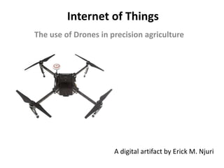
- 1. Internet of Things The use of Drones in precision agriculture A digital artifact by Erick M. Njuri
- 2. 2 IoT solution & benefits in agriculture 2 • The use of drones for observing, measuring and responding to inter and intra-field variability in crops1. • The goal is to define a decision support system for the whole farm management with the goal of optimizing returns on inputs while preserving resources. • We are going to use the precision agriculture normalized difference vegetation index2 (NDVI) drones in this solution. IoT solution • The solutions will reduce on the overall operational costs due to reduced hassle of manned services. • The use of NDVI maps is the key to boosting yields, cutting costs, and driving your business forward. It highlights exactly which areas of crop need closer examination meaning less time spent scouting, and more time treating the plants that need attention3 Benefits 1 https://en.wikipedia.org/wiki/Precision_agriculture 2 https://youtu.be/rxOMhQwApMc 3 https://youtu.be/xsm3bogEhYY
- 3. Technologies Feature Requirement Comment Network Area Wide The area covered is wide and in an outdoor setup. Spectrum Shared Shared spectrum will be suitable. The Quality of service (timeliness) of transmission is not a crucial factor. Battery life Short Typically, drones have a automated landing sequence where they return back whenever the battery is low. They can then be replaced or recharged. Connectivity cost Medium The connection cost will be moderate although it is highly dependent on the country. This can also be affected by the location of the farm because if the farm is in a very remote place, the connection costs may increase. Module cost Low The module cost for this solution is expected to be low. Bandwidth Low Low bandwidth will be enough to cater for the data being collected. 3https://www.gsmatraining.com/lessons/internet-things-session-5/
- 4. Technologies Cont... Feature Requirement Comment Connection technologies Wi-Fi among others i.e Satellite and Cellular (e.g 3G, 4G). Drones can be remotely controlled through the use of Wi-Fi technologies. Smart phones are used to direct and monitor the drones. In more advanced farming, satellite technology can also be used. Smart farmers can access the information through cellular technologies from wherever they are. 4
- 5. Business models Business models Revenue of the IoT company Device ownership Revenue-sharing Recurring IoT company Cost-savings sharing Recurring IoT company Product-sharing Usage IoT company Product-as-a-Service Recurring IoT company Performance-as-a-Product Usage User Transactional Upfront User There are two possible business models for this application1 1. Product as a service – Here, the IoT company may offer the service without demanding for an upfront charge and instead, the customer will be paying a monthly fee. This fee will include both the rental charges and ongoing service support 2. Transactional – Here, the IoT company will charge upfront for the product. This is because the cost of the solution is relatively cheap. 1 https://www.gsmatraining.com/lessons/internet-things-session-5/
- 6. Operational issues & policy topics 6 Operational considerations • Drone flying away, going out of control • Interference with other flying objects • Preparing for takeoff and landing, may cause injury or destruction of property • Verifying the Imagery and the data that was collected. Policy areas • Privacy /threat of surveillance1 • Security • Interference with the natural ecosystem (see image below) A flock of pigeons flies with a prototype “parcelcopter” of German postal and logistics group Deutsche Post DHL in Bonn December 9, 2013. REUTERS/Wolfgang Rattay 1 https://www.brookings.edu/research/drones-and-aerial-surveillance-considerations-for-legislatures/
- 7. Image depicting two plants; left (healthy) and right (unhealthy) with NDVI reflectance VI algorithm. Courtesy of NASA. The end