LITERATURE REVIEW ON RAPID VISUAL SURVEY AND SEISMIC VULNERABILITY
•
2 likes•462 views

The rapid visual screening procedure (RVS) is a method of survey for an audience, which includes building officials and inspectors, and government agency and private-sector building owners to rank buildings that are seismically hazardous. Although RVS is carried out at a large scale after the 2001 earthquake. We have carried out this survey in a large scale in Ahmedabad and Gandhinagar and looking forward to do it in furthermore cities. In this paper we aim to share our work basics and the methodology we followed.
![Literature Review on Rapid Visual Survey and Seismic Vulnerability
(IJSRD/Vol. 2/Issue 09/2014/100)
All rights reserved by www.ijsrd.com 446
1) Verifying and updating the building identification
information;
2) Walking around the building to identify its size and
shape, and sketching a plan and elevation view on
the Data Collection Form;
3) Determining and documenting occupancy;
4) Determining soil type, if not identified during the
pre-planning process;
5) Identifying potential nonstructural falling hazards,
if any, and indicating their existence on the Data
Collection Form;
6) Identifying the seismic lateral-load resisting system
(entering the building, if possible, to facilitate this
process) and circling the related Basic Structural
Hazard Score on the Data Collection Form;
7) Identifying and circling the appropriate seismic
performance attribute Score Modifiers (e.g.,
number of stories, design date, and soil type) on the
Data Collection Form;
8) Determining the Final Score, S (by adjusting the
Basic Structural Hazard Score with the Score
Modifiers identified in Step 7), and deciding if a
detailed evaluation is required; and
9) Photographing the building and attaching the photo
to the sheet.
Other conclusions and recommendations pertaining
procedure that emanated from these applications included
the following:
Involve design professionals in RVS
implementation whenever possible to ensure that
the lateral-force-resisting structural systems are
correctly identified (such identification is
particularly difficult in buildings that have been
remodeled and added to over the years);
Conduct intensive training for screeners so that
they fully understand how to implement the
methodology, in all of its aspects;
Inspect both the exterior and, if at all possible, the
interior of the building;
Review construction drawings as part of the
screening process;
Review soils information prior to implementation
of the methodology in the field; and
Interpret the results screenings in a manner
consistent with the level of resources available for
the screening.
The survey sheet is shown from the next page onwards.
1) Advantages of RVS:
Reduced interruption to business;
Reduced potential for secondary damage (for
example, fires) that could impact otherwise
undamaged structures;
Reduced potential for traffic flow problems around
areas of significant damage; and
Other reduced economic impacts.
2) Uses of RVS Survey Results:
While the principal purpose of the RVS procedure is to
identify potentially seismically hazardous buildings needing
further evaluation, results from RVS surveys can also be
used for other purposes. These include:
Ranking a community’s (or agency’s) seismic
rehabilitation needs;
Designing seismic hazard mitigation programs for
a community (or agency);
Developing inventories of buildings for use in
regional earthquake damage and loss impact
assessments;
Planning post-earthquake building safety
evaluation efforts; and
Developing building specific seismic vulnerability
information for purposes such as Insurance rating,
decision making during building ownership
transfers, and possible triggering of remodeling
requirements during the permitting process
REFERENCES
[1] FEMA 154, Edition 2 / March 2002
[2] ST integrated rapid visual screening, US
department of homeland services](data:image/gif;base64,R0lGODlhAQABAIAAAAAAAP///yH5BAEAAAAALAAAAAABAAEAAAIBRAA7)
Recommended
Recommended
More Related Content
Similar to LITERATURE REVIEW ON RAPID VISUAL SURVEY AND SEISMIC VULNERABILITY
Similar to LITERATURE REVIEW ON RAPID VISUAL SURVEY AND SEISMIC VULNERABILITY (20)
More from ijsrd.com
More from ijsrd.com (20)
Recently uploaded
Recently uploaded (20)
LITERATURE REVIEW ON RAPID VISUAL SURVEY AND SEISMIC VULNERABILITY
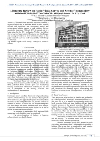
- 1. IJSRD - International Journal for Scientific Research & Development| Vol. 2, Issue 09, 2014 | ISSN (online): 2321-0613 All rights reserved by www.ijsrd.com 445 Literature Review on Rapid Visual Survey and Seismic Vulnerability Abhi Gandhi1 Shalin Shah2 Yash Mehta3 Mr. Abhijitsinh Parmar4 Dr. V. M. Patel5 1,2,3 B.E. Student 4 Assistant Professor 5 Principal 1,2,3,4 Department of Civil Engineering 1,2,3,4,5 Shankersinh Vaghela Bapu Institute of Technology Abstract— The rapid visual screening procedure (RVS) is a method of survey for an audience, which includes building officials and inspectors, and government agency and private-sector building owners to rank buildings that are seismically hazardous. Although RVS is carried out at a large scale after the 2001 earthquake. We have carried out this survey in a large scale in Ahmedabad and Gandhinagar and looking forward to do it in furthermore cities. In this paper we aim to share our work basics and the methodology we followed. Key words: Rapid Visual Survey, Earthquakes, beam-to- column I. INTRODUCTION Rapid visual survey involves a survey of a real or potential disaster to estimate the actual or expected damage and to make recommendations for prevention, preparedness and response. The survey of the expected damages for a potential disaster essentially consists of risk evaluation. Risk is defined as the expected losses (of lives, persons, injured, property damaged, and economic activity disrupted) due to particular hazard for a given area and reference period. Its principal purpose is to identify older buildings designed and constructed before the adoption of adequate seismic design and detailing requirements, buildings on soft or poor soils, or buildings having performance characteristics that negatively influence their seismic response. The RVS uses a methodology based on a “sidewalk survey” of a building and a Data Collection Form, which the person conducting the survey (here after referred to as the screener) Completes, based on visual observation of the building from the exterior, and if possible, the interior. The Data Collection Form includes space for documenting building identification information, including its use and size, a photograph of the building, sketches, and documentation of pertinent data. A. Earthquakes: Four major factors can affect the severity of ground shaking and thus potential damage at a site. These are the magnitude of the earthquake, the type of earthquake, the distance from the source of the earthquake to the site, and the hardness or softness of the rock or soil at the site. Larger earthquakes will shake longer and harder, and thus cause more damage. Experience has shown that the ground motion can be felt for several seconds to a minute or longer. In preparing for earthquakes, both horizontal (side to side) and vertical shaking must be considered. Fig shows:-Locations of failures at beam-to- column joints in non-ductile frames Ref: FEMA 154 E: Characteristics and Earthquake Performance of RVS Building Types Earthquake to the site, and the hardness or softness of the rock or soil at the site larger earthquakes will shake longer and harder, and thus cause more damage. Experience has shown that the ground motion can be felt for several seconds to a minute or longer. In preparing for earthquakes, both horizontal (side to side) and vertical shaking must be considered. Earthquakes have caused heavy damages in terms of deaths, injuries, destruction of habitat and disruption of economic activity that have left scars on a large section of population in wide areas. Realizing the potentially catastrophic consequences of largely unpredictable earthquakes, particularly in growing urban areas in different seismic zones of South Asia, it has become imperative that countries of the region pull their resources, expertise and strengths and share their experiences with each other in assessing the risk of earthquakes at regional and local levels, mitigate the risks through a combination of structural and nonstructural measures, respond to the earthquake events by rapid response and relief to the victims and reconstruct the damaged houses, infrastructure and livelihood to restore normal life and economy in the affected areas. B. Rapid visual survey: There are several steps involved in planning and performing an RVS of potentially seismically hazardous buildings. As a first step, if it is to be a public or community project, the local governing body and local building officials should formally approve of the general procedure. Second, the public or the members of the community should be informed about the purpose of the screening process and how it will be carried out. There are also other decisions to be made, such as use of the screening results, responsibilities of the building owners and the community, and actions to be taken. Initial thing is to form a team for the particular area and the building. The different teams focus on different areas which follow the steps given below, Here we are using a survey sheet prepared by us in which there are certain criteria’s mentioned to be noted for a building. The survey sheet is completed for each building screened through execution of the following steps:
- 2. Literature Review on Rapid Visual Survey and Seismic Vulnerability (IJSRD/Vol. 2/Issue 09/2014/100) All rights reserved by www.ijsrd.com 446 1) Verifying and updating the building identification information; 2) Walking around the building to identify its size and shape, and sketching a plan and elevation view on the Data Collection Form; 3) Determining and documenting occupancy; 4) Determining soil type, if not identified during the pre-planning process; 5) Identifying potential nonstructural falling hazards, if any, and indicating their existence on the Data Collection Form; 6) Identifying the seismic lateral-load resisting system (entering the building, if possible, to facilitate this process) and circling the related Basic Structural Hazard Score on the Data Collection Form; 7) Identifying and circling the appropriate seismic performance attribute Score Modifiers (e.g., number of stories, design date, and soil type) on the Data Collection Form; 8) Determining the Final Score, S (by adjusting the Basic Structural Hazard Score with the Score Modifiers identified in Step 7), and deciding if a detailed evaluation is required; and 9) Photographing the building and attaching the photo to the sheet. Other conclusions and recommendations pertaining procedure that emanated from these applications included the following: Involve design professionals in RVS implementation whenever possible to ensure that the lateral-force-resisting structural systems are correctly identified (such identification is particularly difficult in buildings that have been remodeled and added to over the years); Conduct intensive training for screeners so that they fully understand how to implement the methodology, in all of its aspects; Inspect both the exterior and, if at all possible, the interior of the building; Review construction drawings as part of the screening process; Review soils information prior to implementation of the methodology in the field; and Interpret the results screenings in a manner consistent with the level of resources available for the screening. The survey sheet is shown from the next page onwards. 1) Advantages of RVS: Reduced interruption to business; Reduced potential for secondary damage (for example, fires) that could impact otherwise undamaged structures; Reduced potential for traffic flow problems around areas of significant damage; and Other reduced economic impacts. 2) Uses of RVS Survey Results: While the principal purpose of the RVS procedure is to identify potentially seismically hazardous buildings needing further evaluation, results from RVS surveys can also be used for other purposes. These include: Ranking a community’s (or agency’s) seismic rehabilitation needs; Designing seismic hazard mitigation programs for a community (or agency); Developing inventories of buildings for use in regional earthquake damage and loss impact assessments; Planning post-earthquake building safety evaluation efforts; and Developing building specific seismic vulnerability information for purposes such as Insurance rating, decision making during building ownership transfers, and possible triggering of remodeling requirements during the permitting process REFERENCES [1] FEMA 154, Edition 2 / March 2002 [2] ST integrated rapid visual screening, US department of homeland services
- 3. Literature Review on Rapid Visual Survey and Seismic Vulnerability (IJSRD/Vol. 2/Issue 09/2014/100) All rights reserved by www.ijsrd.com 447 SURVEY SHEET
- 4. Literature Review on Rapid Visual Survey and Seismic Vulnerability (IJSRD/Vol. 2/Issue 09/2014/100) All rights reserved by www.ijsrd.com 448