The Crucial Role of Utility-Locating Companies
•
0 likes•2 views

The Crucial Role of Utility-Locating Companies

Recommended
Recommended
More Related Content
Similar to The Crucial Role of Utility-Locating Companies
Similar to The Crucial Role of Utility-Locating Companies (20)
More from Tec
More from Tec (20)
Recently uploaded
Recently uploaded (20)
The Crucial Role of Utility-Locating Companies
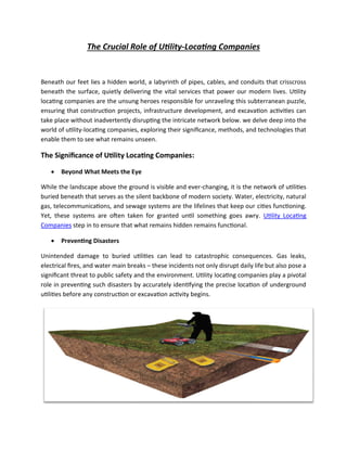
- 1. The Crucial Role of Utility-Locating Companies Beneath our feet lies a hidden world, a labyrinth of pipes, cables, and conduits that crisscross beneath the surface, quietly delivering the vital services that power our modern lives. Utility locating companies are the unsung heroes responsible for unraveling this subterranean puzzle, ensuring that construction projects, infrastructure development, and excavation activities can take place without inadvertently disrupting the intricate network below. we delve deep into the world of utility-locating companies, exploring their significance, methods, and technologies that enable them to see what remains unseen. The Significance of Utility Locating Companies: • Beyond What Meets the Eye While the landscape above the ground is visible and ever-changing, it is the network of utilities buried beneath that serves as the silent backbone of modern society. Water, electricity, natural gas, telecommunications, and sewage systems are the lifelines that keep our cities functioning. Yet, these systems are often taken for granted until something goes awry. Utility Locating Companies step in to ensure that what remains hidden remains functional. • Preventing Disasters Unintended damage to buried utilities can lead to catastrophic consequences. Gas leaks, electrical fires, and water main breaks – these incidents not only disrupt daily life but also pose a significant threat to public safety and the environment. Utility locating companies play a pivotal role in preventing such disasters by accurately identifying the precise location of underground utilities before any construction or excavation activity begins.
- 2. • Cost Savings and Efficiency Imagine embarking on a construction project only to realize midway that you've accidentally damaged a major water line. The cost of repairs, delays, and regulatory fines can quickly spiral out of control. Utility locating companies save businesses and municipalities substantial amounts by helping them avoid such costly blunders. By accurately mapping out the underground infrastructure, these companies enable projects to proceed smoothly, minimizing interruptions and unexpected expenses. The Methods Behind The Magic: • Digging into the Past Unearthing the history of utility locating takes us back to the days when early civilizations devised ingenious ways to transport water, construct sewage systems, and build rudimentary communication networks. As society progressed, so did the complexity of these systems. Today, utility locating companies employ a mix of historical records, as-built drawings, and advanced technologies to piece together the puzzle of buried utilities. • The Art of Non-Invasive Exploration Gone are the days when utility location was a hit-or-miss affair involving shovels and guesswork. Modern utility locating is a precise science that employs cutting-edge technology to map underground networks without the need for invasive digging. Ground-penetrating radar (GPR), electromagnetic induction, and acoustic detection are among the tools in the utility locator's arsenal, allowing them to "see" through layers of soil and identify the presence of utilities. • Data Fusion and Interpretation The real magic happens when raw data collected from various sources is fused and interpreted to create a comprehensive map of underground utilities. This process involves combining data from GPR scans, electromagnetic surveys, and historical records. Advanced software algorithms then analyze the data, removing noise and false positives, to produce accurate depictions of utility locations. This fusion of data and technology empowers utility-locating companies to provide precise information to their clients. The Tech Titans of Utility Location: • Ground-Penetrating Radar (GPR) Ground-penetrating radar, often referred to as the "sonar of the underground," is a cornerstone technology in the Utility Locating toolkit. By emitting high-frequency radio waves into the ground
- 3. and measuring the time it takes for the signals to bounce back, GPR systems can create detailed subsurface profiles. This enables utility locators to identify the composition of soil layers, spot anomalies, and map out buried structures accurately. • Electromagnetic Induction Electromagnetic induction technology leverages the principle of electromagnetic fields. By inducing a magnetic field in the ground using a transmitter and measuring the resulting electromagnetic responses with a receiver, utility locators can detect conductive materials like metallic pipes and cables. This method is particularly useful for tracing the paths of buried utilities and estimating their depths. • Augmented Reality and Digital Mapping As technology evolves, utility-locating companies are integrating augmented reality (AR) and digital mapping tools into their workflows. These tools overlay utility data onto real-world visuals, offering a more intuitive understanding of underground layouts. Clients can "see" utility paths through AR glasses or on digital devices, enabling better decision-making during construction and excavation projects. The Future of Unearthing The Subsurface: • Advancements in Automation The future promises even more efficiency in utility locations, thanks to advancements in automation and artificial intelligence. Machine learning algorithms can enhance data analysis, quickly identifying patterns and anomalies in vast amounts of data collected from various sources. This automation reduces the time required for data interpretation and increases the accuracy of utility mapping. • Integration with Smart Cities As cities become smarter and more connected, the need for accurate utility data becomes paramount. Utility locating companies are poised to play a crucial role in this evolution by providing real-time utility information to smart city systems. This integration enhances urban planning, maintenance, and emergency response, contributing to safer and more efficient urban environments. • Eco-Friendly Approaches The environmental impact of construction and excavation activities can be significant. Utility locating companies are exploring eco-friendly techniques that minimize disruption to ecosystems
- 4. while still ensuring accurate utility mapping. From using renewable energy to power their equipment to employing non-invasive methods that reduce soil disturbance, these companies are aligning their practices with sustainable goals. Conclusion: Utility locating companies are the modern-day cartographers of the underground, deciphering the intricate web of utilities that power our lives. Their significance in preventing disasters, saving costs, and enabling efficient construction is undeniable. Through a combination of historical research, cutting-edge technology, and data interpretation, these companies reveal what lies beneath the surface, guiding us toward a safer and more sustainable future. As technology continues to advance, utility locating will evolve, and we can look forward to a world where the unseen is no longer a mystery but a well-mapped landscape ready for exploration.