SlideShare a Scribd company logo
1 of 28
Download to read offline
Journal of Petroleum Geology, Vol. 28(3), July 2005, pp 241-268                                 241


          LATE TO MIDDLE JURASSIC SOURCE FACIES
          AND QUALITY VARIATIONS, SOUTH VIKING
          GRABEN, NORTH SEA

          H. Justwan*1, B. Dahl1, G.H. Isaksen2 and I. Meisingset3


              Source facies and quality of the Late to Middle Jurassic source rock system in the South Viking
          Graben between 58ºN and 60º15’N are highly variable both regionally and stratigraphically. In
          order to assess the degree of variability and to create a model of source rock quality and potential,
          isochore maps of the syn- and post-rift sections of the Upper Jurassic Draupne Formation and
          underlying Heather Formation were generated from seismic and well data, and maturity-corrected
          Rock-Eval data were used to generate quantitative maps of oil and gas potential.The thin post-rift
          section at the top of the Draupne Formation is a rich oil-prone source, while the up to 1,600 m
          thick syn-rift section contains a mixture of Type III and Type II material with substantial amounts
          of gas-prone and inert organic matter.The Heather Formation, which reaches modelled thicknesses
          of up to 930 m, is a lean source and is generally gas-prone.
              Detailed analyses and interpretations of biomarker and isotopic characteristics support this
          upward increase in oil-prone Type II material.The analytical parameters include increasing relative
          amounts of C27 regular steranes; decreasing ratios of C30 moretane relative to C30 hopane; and an
          increasing predominance of short chain n-alkanes and progressively lighter isotopic values for
          saturate and aromatic fractions of source rock extracts. In addition, increasing amounts of
          17α(H),21β(H)-28,30-bisnorhopane and decreasing amounts of C34 homohopanes relative to
          C35 homohopanes, as well as decreasing Pr/Ph ratios, suggest a general decrease in oxygenation
          upwards. Maps of average Pr/Ph ratios for the syn- and post-rift Draupne Formation and for the
          Heather Formation are consistent with permanent water column stratification and gradual ascent
          of the O2:H2S interface from the Callovian to the Ryazanian.
              Interpretation of oil and gas potential maps, molecular parameters and estimates of sediment
          accumulation rates in combination suggest that the source facies of the upper, post-rift Draupne
          Formation is controlled by widespread anoxia, reduced siliciclastic dilution and reduced input of
          gas-prone organic and inert material; by contrast, the potential of the lower, syn-rift Draupne
          Formation is strongly controlled by dilution by gas-prone and inert organic matter resulting from
          mass flows and also by varying degrees of oxygenation. The oil and gas potential of the Heather
          Formation is mainly controlled by the degree of oxygenation and siliciclastic dilution.
INTRODUCTION                                                 (Huc et al., 1985; Isaksen and Ledje, 2001; Kubala et
                                                             al., 2003; Justwan and Dahl, 2005). In the area
Source facies and quality of Jurassic source rocks in        between 58º N and 60º15’ N in the Norwegian South
the Viking Graben vary both laterally and vertically         Viking Graben, major differences can be observed
                                                             between syn- and post-rift sections of the Draupne
1
  Department of Earth Science, University of Bergen,         Formation (Justwan and Dahl, 2005). As more data
Allegaten 41, 5007 Bergen, Norway.                           concerning Jurassic source rocks in the mature
2
   ExxonMobil Exploration Company, 233 Benmar,               exploration area of the South Viking Graben become
Houston, Texas 77210, USA.                                   available, it is becoming evident that source facies
3
  Aker Kvaerner Geo AS, PO Box 242, Lilleaker, 0216          distribution can no longer be explained by simple
Oslo, Norway.                                                models and that it is controlled by numerous factors.
*corresponding author, email: holger.justwan@geo.uib.no      The new data has enabled us to construct a more
242          Late to Middle Jurassic source facies and quality variations, South Viking Graben, North Sea


reliable model of source rock distribution, potential        regional doming during the Middle Jurassic. Its
and quality than was previously possible. We have            sediments pass transgressively southwards into the
focussed on the Upper Jurassic source interval because       coastal plain deposits of the Sleipner Formation and
only a small amount of new data on the Middle                the shallow-marine to coastal deposits of the Hugin
Jurassic source rocks in the study area was available.       Formation. Middle Jurassic sandstones form important
    This paper forms the first part of a larger study of     reservoir intervals in the area, while the coals and
the petroleum system in the South Viking Graben              coaly shales are source rocks for gas and volatile oils
which will also include an oil-source correlation study      (Isaksen et al., 1998). The organic rich oil- and gas-
and a basin modelling project. The objectives of the         prone shales of the Heather and Draupne Formations
present paper are threefold. The first aim is to produce     were deposited during a sea-level rise in the Late
maps of the thickness and quality of the Upper Jurassic      Jurassic. Intra-Heather and Draupne Formation
source rock section which can be used in basin               sandstones also act as reservoirs in the study area,
modelling. Much attention in recent basin modelling          and are best developed along the western margin of
projects has been given to kinetic parameters (e.g.          the South Viking Graben in the UK Sector. Following
Dieckmann et al., 2004) and phase predictions (e.g.          Late Jurassic rifting, there followed a period of
di Primio, 2002), while the issue of source rock             tectonic quiescence and subsequent uplift and erosion
variability as an important input parameter is rarely        of the East Shetland Platform, resulting in the
addressed. We hope to shed light on this important           deposition of submarine fan sandstones of Paleocene
aspect of the petroleum systems of the South Viking          to Eocene age which include important reservoir
Graben by presenting quantitative maps of the oil and        intervals. Continued subsidence with occasional
gas potential in the area. The second objective of this      phases of uplift accompanied by the resulting supply
study is to gain a detailed knowledge of variations in       of sediments from the west resulted in an extensive
source rock quality (including molecular properties)         post-Eocene sedimentary section (Gregersen et al.,
which will later be used in an oil-source correlation        1997).
study within the South Viking Graben. Finally, we
attempt to explain the development of source facies          The Jurassic source rock system
and oil and gas potential in the area in terms of basin      in the South Viking Graben
development through time.                                    The Upper Jurassic Draupne Formation and
                                                             stratigraphic equivalents are the major source rocks
GEOLOGICAL SETTING                                           in the North Sea and have been subject of numerous
                                                             studies (e.g. Barnard and Cooper, 1981; Goff, 1983;
Evolution of the South Viking Graben                         Cooper and Barnard, 1984; Doré et al., 1985; Field,
The present-day structural configuration of the study        1985; Northam, 1985; Cooper et al., 1993; Cornford,
area (Fig. 1) was inherited from two major extensional       1998; Kubala et al., 2003). In addition, the underlying
phases in the Permo-Triassic and the Late Jurassic           Heather Formation together with Middle Jurassic units
(Ziegler, 1992). Permo-Triassic extension was more           also have potential for oil and gas generation (Cooper
pronounced in the Stord Basin on the eastern margin          and Barnard, 1984; Field, 1985; Cornford, 1998;
of the study area, while Jurassic extension mainly           Isaksen et al., 1998; Isaksen et al., 2002). In the
affected the Viking Graben in the west and left the          following paragraphs, we summarise previous studies
Stord Basin largely unaffected (Faerseth, 1996). The         concerning Jurassic source rocks in the study area.
South Viking Graben is asymmetric; it is bound by                The mid-Jurassic Sleipner and Hugin Formations
the East Shetland Platform to the west, and steps up         (Fig. 2) were deposited in a coastal plain to offshore
to the east with numerous fault blocks (Fig. 1) forming      marine setting. The Sleipner Formation, which is up
the Gudrun and Sleipner terraces (Cockings et al.,           to 500 m thick (Husmo et al., 2003), consists mainly
1992; Sneider et al., 1995). The Utsira High, which          of fluvio-deltaic siliciclastics including coals and coaly
was a positive feature at least as early as the Permian      shales, and ranges in age from Bathonian to earliest
(Hanslien, 1987), together with the Ling High                Oxfordian on the margins of the Utsira High (Vollset
constitute the eastern boundary of the graben. The           and Doré, 1984; Cockings et al., 1992). It is
oldest sediments encountered in the area are of              transgressively overlain by the Hugin Formation of
Permian age (Isaksen et al., 2002) and are overlain          latest Bathonian to Early Oxfordian age (Cockings et
by Triassic continental siliciclastics (Fisher and           al., 1992; Husmo et al., 2003) which comprises
Mudge, 1998). Marine sediments of the Lower                  nearshore shallow-marine sandstones and
Jurassic Dunlin Group were deposited during a rise           fluviodeltaic sediments including coals and coaly
in sea level (Skarpnes et al., 1980), but are sparsely       shales (Vollset and Doré, 1984). These Middle Jurassic
preserved south of 59°N. The Brent delta developed           coals and coaly shales have the potential to generate
in the northern half of the study area in response to        gas and volatile oil (Isaksen et al., 1998), and exhibit
H. Justwan et al.                                                                           243


                                                         2°00'                                                       3°00'
                                                                 30/10                                                                                                                         Utsira   Stord
                                                                                    30/11                30/12            31/10             31/11                Viking Graben
                                                                                                                                                                                               High     Basin
                                                                                                     Bjørgvin
                       3/28         3/29           3/30  Fensal                                      Arch 1                                                                   Tertiary
                                                   Frigg Sub-basin
                                                   Ridge                                                                                                        Cretaceous

                                                                                                                                                                                       ssic
          60°00'
                       9/3          9/4            9/5               25/1           25/2                 25/3             26/1              26/2                           a
                   East                                                                                          1                                               er    Jur
                                                                     10             12                                                                       Upp
                   Shetland
                                                                                                                                                                             Schematic SW-NE Cross-section
                   Platform
                       9/8          9/9            9/10                                                                                                                                                     A’
                                                                                                                                                         A
                                                                                                 14
                                                             25/4                   25/5                 25/6             26/4              26/5
                                                            Heimdal     2
                     9/13           9/14           9/15      High Heimdal                                                 1 Stord
                                                                1 Terrace
                                                                                                                                        Basin
                                                          1                                                      2
                                                                                                     3                                                                                            Bergen
                                                                                                             1                                                                         60 oN
                     9/18          9/19             24/9 25/7


                                                                                                                                                                             eridian
                                                                                   25/8                  25/9             26/7              26/8
                                                                                                 7                                                                                                  Norway
                                                                                    5S                   1


                                                                                                                                                                      Prime M
                                      Vana Sub-basin                                                                                                                                            Stavanger
                    9/23           9/24
                                               1                       2                                                     A’
                                          24/12              25/10                 25/11                 25/12            26/10             26/11
                                                                                                                                                                Study
                    9/28                                                              15                                                                        Area
                                                   1R
                                                             6S             Utsira High                                                                                                             Denmark
                                                                          8A                17
          59°00'
                                                                                                                                                                         55 oN
                    16/3            15/3       2            16/1                   16/2                  16/3             17/1              17/2
                                                                       2
                                           3           Gudrun                                                        Patch Bank Ridge                    U.K.
                   A                1S                 Terrace
                   16/8                                          3
                               1                   5
                                     15/6                   16/4                   16/5                  16/6             17/4              17/5
                               3
                             15/5
                   16/13
                           2
                               1                   7

                                     2              8S
                        15/8         15/9                   16/7                   16/8                  16/9             17/7              17/8
                                     3
                                     2              11       2                                                                                                    Cretaceous Basin
                             1            18                                      Ling
                   16/18                           Sleipner                                                                            Sele High
                                                                               Depression                                                                         Pre-Jurassic Basin
                   16/23                           Terrace
                                                                                                                                                                  Terrace, Intra-basinal High
                                    15/12                   16/10                  16/11                 16/12            17/10             17/11
                                     11S                                       3
                   16/28 16/29                                                             2                                                                      Platform, High
                                                             2        4
                                                    10S                                                      0       10       20       30      40   50

          58°00'
                                                                                                                                  km
                                                    2°00'                                                            3°00'


Fig.1. General map of the South Viking Graben showing major structural elements (after Norwegian
Petroleum Directorate, 2005) and the location of the wells used in quantitative source rock mapping.
The schematic SW-NE cross-section (after Isaksen and Ledje, 2001) displays the structure of the South Viking
Graben, the flanking highs and the adjacent Stord Basin (line of section A-A’ in main map). The location of the
study area in the North Sea is shown in the overview map (lower right).

TOC values of up to 80 wt % and Hydrogen Indices                                                                                            water column, whose deposition was terminated by
up to 400 g HC/kg Corg (Isaksen et al., 2002). Shales                                                                                       increasing oxygenation accompanying a progressive
and grey silty mudstones of the Callovian to Oxfordian                                                                                      transgression.
Heather Formation have average TOC values up to                                                                                                 The Heather Formation is diachronously overlain
4% (Goff, 1983; Cooper and Barnard, 1984; Field,                                                                                            by the Oxfordian to Ryazanian (Kimmeridge Clay
1985; Thomas et al., 1985). It is generally thought                                                                                         Equivalent) Draupne Formation (Vollset and Doré,
that this formation is a lean dry gas source, although                                                                                      1984) (Fig. 2). Various depositional models for this
it shows large variations in source potential and has                                                                                       unit have been put forward (e.g. Hallam and
good hydrocarbon potential in some small sub-basins                                                                                         Bradshaw, 1979; Tyson et al., 1979; Demaison and
(Cooper and Barnard, 1984; Field, 1985; Thomas et                                                                                           Moore, 1980; Parrish and Curtis, 1982; Oschmann,
al., 1985; Scotchman, 1991; Gormly et al., 1994;                                                                                            1988; Miller, 1990). The well studied onshore
Isaksen et al., 2002). Thomas et al. (1985) described                                                                                       outcrops are however not easily comparable in age or
a widespread basal-Heather “hot shale” deposited                                                                                            facies with the offshore equivalent (Wignall, 1994).
under dysoxic to anoxic conditions beneath a stratified                                                                                     It is generally agreed that deposition of the offshore
244                Late to Middle Jurassic source facies and quality variations, South Viking Graben, North Sea


  Rel.Sea                      Age                         Gen.
                                                                          Lithostratigraphy                                                         Major Events
   Level*        (after Hardenbol et al. Seq. (after Doré et al. 1985; Thomas et al.                              (after Rawson & Riley 1982; Cockings et al.1992; Cornford, 1998; Fraser et al. 2003)
                         1998)                 1985; Cockings et al.1992; Fraser
High       Low   Ma                       *                         W           et al. 2003)            E

                      Cretaceous
                                                  Late                                                       -Basin flushing in Late Ryazanian ends Draupne deposition
                                    Ryazanian
                                                                                                             -Thermal subsidence prevails

                                                           E              Upper Draupne                      -No active fan systems
              140                                 Early                     Formation
                                                                                                             -Upper Draupne deposited as draping post-rift clay layer

                                                  Late
                                                                         Intra-Draupne                           -Only minor extension, thermal subsidence dominates, onset of post-rift
                                                                             sands                               phase, abandonment of fan systems
                                                  Middle D                                                                             Transition syn- to post-rift
                                                                        Lower Draupne
                                   Volgian


                                                                          Formation                          -Deep water fan systems become very abundant and prograde eastwards from
                                                                                               Utsira High
                                                                                                             East Shetland Platform, also sand input from Utsira High
                                                  Early     C
                                                                                                             -Deposition of Lower Draupne Formation with widespread change to dysoxic
                                                                    Intra-Draupne                            facies
              150                                                       sands
                                   Kimmeridgian


                                                  Upper
                                                                                                             -Intensification of rifting activity
                      Jurassic


                                                  Lower
                                                                                                             -Active fan systems sourced from Utsira High and East Shetland Platform
                                                            B
                                                  Upper
                                   Oxfordian


                                                                                Heather
                                                                                Formation
                                                  Middle
                                                            A
                                                                                                             -Accelerated rifting and deepening
                                                  Lower                  Intra-Heather
                                                                             sands
              160                                 Upper
                                   Callovian


                                                                                                             -Continuing southward transgression of Boreal sea along graben axis gives rise
                                                                                        n


                                                  Middle
                                                                                        io


                                                                                                             to deposition of Heather shales
                                                                                    at
                                                                                   rm
                                                                                Fo
                                                            Pre A


                                                  Lower
                                                                             n


                                                                                                             -Deposition of coastal plain sediments including sands, coals and coaly shales of
                                                                            gi
                                                                           Hu


                                                                                                             the Sleipner Formation and nearshore sands to coastal plain deposits of the
                                                                                                             Hugin Formation
                                   Bathonian


                                                  Upper                 Sleipner
                                                                        Formation
                            Middle
                            Lower
*Relative sea-level and genetic sequences after Fraser et. al (2003)


Fig. 2. General stratigraphic chart of the Upper to Middle Jurassic succession in the South Viking Graben with
a summary of the major tectonic and depositional events. The Oxfordian to Kimmeridgian Draupne
Formation can be divided into an upper post-rift section including genetic sequences D and E (Fraser et al.,
2003) and a lower syn-rift section. The Draupne and Heather Formation contain a series of sands sourced
from the flanking highs, the East Shetland Platform and the Utsira High.

Kimmeridge Clay occurred in a shallow sea with anoxic                                                                       2003). The upper and lower parts of the Draupne
bottom waters (Cornford, 1998), although the degree                                                                         Formation were therefore considered separately in
of oxygenation appears to decrease from the lower to                                                                        the present study.
the upper Draupne Formation (Thomas et al., 1985;                                                                               In general, these sections correspond to post- and
Justwan and Dahl, 2005). The Draupne Formation has                                                                          syn-rift successions although the identification of
TOC up to 12 wt% (Thomas et al., 1985) and Hydrogen                                                                         these intervals is difficult in the study area
Indices which are well over 600 g HC/kg C org.                                                                              (Gabrielsen et al., 2001; see also Rawson and Riley,
However, the formation has large lateral and vertical                                                                       1982; and Rattey and Hayward, 1993). For this study,
variations in source quality (Field, 1985; Huc et al.,                                                                      the base of the J70 sequence of Rattey and Hayward
1985; Scotchman, 1991; Cooper et al., 1993; Isaksen                                                                         (1993) was chosen as the base of the post-rift section.
and Ledje, 2001; Kubala et al. 2003), especially in the                                                                     This corresponds to the base of genetic sequence D
narrow South Viking Graben whose fringing land areas                                                                        of Middle Volgian age of Fraser et al. (2003), and
were the source of terrestrial organic matter. It has been                                                                  the Ti5 sequence boundary of Jacquin et al. (1998)
observed not only that the terrestrial contribution                                                                         (Fig. 2). Gamma-ray log pattern and geochemical data
decreases upwards (Huc et al., 1985), but also that there                                                                   were utilized in addition (see below). The lowermost
is a distinct difference in source facies and potential                                                                     section of the syn-rift lower Draupne Formation was
between the upper and lower parts of the formation.                                                                         deposited during intensifying rift activity and rising
Thus, the upper section has better source quality and                                                                       relative sea level (genetic sequence B, see Fig. 2)
richness, while the lower part has a higher content of                                                                      with fan systems shedding sands from the surround-
Type III kerogen (Field, 1985; Huc et al., 1985; Isaksen                                                                    ing highs. The South Viking Graben contains a series
and Ledje, 2001; Isaksen et al., 2002; Kubala et al.,                                                                       of these basinward-thinning and -fining sandy
H. Justwan et al.                                            245


wedges of Kimmeridgian to Volgian age (Thomas et             GC-MS data (26 wells) and isotope data (21 wells)
al., 1985; Sneider et al., 1995; Underhill, 1998;            obtained from the Norwegian Petroleum Directorate,
Isaksen and Ledje, 2001) which are interpreted to be         Esso Exploration and Production A/S Norway or
proximal deep-water slope apron complexes sourced            previous projects at the University of Bergen were
from the East Shetland Platform and the Utsira High          also used.
(Underhill, 1998; Fraser et al., 2003). They contain             Solvent extraction was carried out with a SOXTEC
large amounts of reworked terrestrial organic matter         System HT2 1045 extraction unit on washed, crushed
(Cooper et al., 1993; Isaksen and Ledje, 2001; Justwan       and ground cutting samples with dichloromethane/
and Dahl, 2005). Rifting intensified in the Early            methanol (93:7) as solvent. The asphaltene fraction
Volgian and widespread dysoxic conditions were               of all samples was precipitated by adding an excess
established (Fraser et al., 2003). A regressive episode      amount of n-pentane, following the procedure
followed in the Middle Volgian while fan deposition          suggested in Weiss et al. (2000). For GC, GC-MS and
continued.                                                   isotope analysis, preparative group-type separation of
    The upper Draupne Formation represents a clay            the maltene fraction was carried out using medium
layer deposited during thermal subsidence after the          pressure liquid chromatography (MPLC) following
cessation of rifting. Its lowermost section was              methods modified from Radke et al. (1980). The
deposited during the late Middle Volgian when fan            carbon isotopic analysis of the saturate and aromatic
systems became less common. The uppermost section,           fractions was carried out on a Carlo Erba NA 1500
corresponding to genetic sequence E of Fraser et al.         elementary analyser and a Finnigan MAT Delta E
(2003), does not show the influence of fans (Fig.2).         online mass spectrometer. All results are reported
Mass flows from surrounding highs therefore had              against PDB. The saturate hydrocarbon fraction of
much less of an influence in the upper Draupne               extracts of all source rock samples from wells 15/9-
Formation.                                                   18, 25/5-5, 25/7-2, 16/7-2 and 25/1-10 were analysed
    In general, areas surrounding highs and close to         using a Hewlett Packard GC-MSD, consisting of a
the palaeo-shoreline were dominated by the deposition        HP 6890 GC Plus, a HP 5973 Mass Selective Detector
of Type III and IV organic matter (Thomas et al., 1985;      operating in SIM mode at the University of Bergen.
Cooper et al., 1993; Kubala et al., 2003). The deep,         The GC unit was equipped with two HP 19091Z-105
basinal sections are richest in Type II organic matter       HP-1 methyl siloxane columns each of 50 m nominal
(Thomas et al., 1985; Miller, 1990; Cornford, 1998),         length, 200 µm nominal diameter and 0.33 µm
with a typical concentric, outward-decreasing TOC            nominal film thickness. The oven’s initial temperature
distribution (Huc, 1988; Cooper et al., 1993).               was 50°C and increased regularly during 20 minutes
Although the basinal sections are generally oil prone,       to an end temperature of 310°C until 80 minutes.
they can potentially contain large amounts of inertinite     Helium was used as the carrier gas. The temperature
transported by mass flow processes (Tyson, 1989;             of the FID was 320°C and the hydrogen flow was 40
Thomas et al., 1985). Below, using recently-acquired         ml/min, while the airflow was held at 400 ml/min.
data, we investigate if these general assumptions are            The saturate hydrocarbon fractions of samples
still applicable to the South Viking Graben, and             from wells 15/3-3, 15/3-5 and 16/1-2 (location see
attempt to determine the controls on the distribution        Fig.1) were analysed on the same system, but using
of organic facies in this area.                              two HP 19091J-102 HP-5 5% phenyl methyl siloxane
                                                             columns of 25 m nominal length. The oven’s initial
SAMPLES, DATA, ANALYTICAL METHODS                            temperature was 70°C, increased during 20 minutes
                                                             to an end temperature of 310°C until 60 minutes, and
A large Rock-Eval database was available comprising          the airflow was held at 450 ml/min. GC and GCMS
samples from 47 wells in the study area, of which            ratios were calculated from measured peak heights.
eight where analysed during this project using a Vinci       For all analyses performed, standards were run every
Technologies Rock-Eval 6 in bulk rock mode. The              tenth sample to ensure analytical quality and
remaining data is derived from geochemical service           comparability of results.
reports publicly available from the Norwegian
Petroleum Directorate or were provided by Esso               RESULTS AND DISCUSSION
Norway. Cuttings provided by the Norwegian
Petroleum Directorate for this project from the source       Thickness, areal extent and accumulation rates
rock sections of eight wells were analysed by gas            of the Upper Jurassic source rock intervals
chromatography (GC) and gas chromatography-mass              For basin modelling, the quality and potential of the
spectrometry (GC-MS). In addition, the isotopic              source rock as well as the thickness of the respective
composition of 15 samples from well 15/9-18 were             source intervals should be investigated. To produce
analysed. Vitrinite reflectance data (36 wells), GC and      isochore maps of the upper Draupne, lower Draupne
Paper2 justwan
Paper2 justwan
Paper2 justwan
Paper2 justwan
Paper2 justwan
Paper2 justwan
Paper2 justwan
Paper2 justwan
Paper2 justwan
Paper2 justwan
Paper2 justwan
Paper2 justwan
Paper2 justwan
Paper2 justwan
Paper2 justwan
Paper2 justwan
Paper2 justwan
Paper2 justwan
Paper2 justwan
Paper2 justwan
Paper2 justwan
Paper2 justwan
Paper2 justwan

More Related Content

What's hot

Final Buttston Tech Report 8-31-2014
Final Buttston Tech Report 8-31-2014Final Buttston Tech Report 8-31-2014
Final Buttston Tech Report 8-31-2014Robert Singleton
 
Stratigraphical calibration of deep water Cretaceous sequences, offshore mid ...
Stratigraphical calibration of deep water Cretaceous sequences, offshore mid ...Stratigraphical calibration of deep water Cretaceous sequences, offshore mid ...
Stratigraphical calibration of deep water Cretaceous sequences, offshore mid ...Stephen Crittenden
 
Source rock maturation studies using vitrinite reflectance and geothermal dat...
Source rock maturation studies using vitrinite reflectance and geothermal dat...Source rock maturation studies using vitrinite reflectance and geothermal dat...
Source rock maturation studies using vitrinite reflectance and geothermal dat...Premier Publishers
 
2016.11.01 Atlantic Irl (1)
2016.11.01 Atlantic Irl (1)2016.11.01 Atlantic Irl (1)
2016.11.01 Atlantic Irl (1)Lewis Whiting
 
The Impact of Seismic Facies Analysis on the Reservoir Architecture of “CHARL...
The Impact of Seismic Facies Analysis on the Reservoir Architecture of “CHARL...The Impact of Seismic Facies Analysis on the Reservoir Architecture of “CHARL...
The Impact of Seismic Facies Analysis on the Reservoir Architecture of “CHARL...IJSRED
 
A REVIEW OF GROWTH FAULTS AND ROLLOVER ANTICLINES (A CASE STUDY OF NIGER DELTA)
A REVIEW OF GROWTH FAULTS AND ROLLOVER ANTICLINES (A CASE STUDY OF NIGER DELTA) A REVIEW OF GROWTH FAULTS AND ROLLOVER ANTICLINES (A CASE STUDY OF NIGER DELTA)
A REVIEW OF GROWTH FAULTS AND ROLLOVER ANTICLINES (A CASE STUDY OF NIGER DELTA) James Opemipo OLOMO
 
Samec - Regression analysis of relations among main Quaternary environmental ...
Samec - Regression analysis of relations among main Quaternary environmental ...Samec - Regression analysis of relations among main Quaternary environmental ...
Samec - Regression analysis of relations among main Quaternary environmental ...swenney
 
2015 Broken Hill Resources Investment Symposium - Geological Survey of New So...
2015 Broken Hill Resources Investment Symposium - Geological Survey of New So...2015 Broken Hill Resources Investment Symposium - Geological Survey of New So...
2015 Broken Hill Resources Investment Symposium - Geological Survey of New So...Symposium
 
Chartership_Interview. LinkedIn
Chartership_Interview. LinkedInChartership_Interview. LinkedIn
Chartership_Interview. LinkedInRam Ben-david
 
Dissertation d ibba_thurley_ct
Dissertation d ibba_thurley_ctDissertation d ibba_thurley_ct
Dissertation d ibba_thurley_ctCallum Thurley
 

What's hot (18)

Final Buttston Tech Report 8-31-2014
Final Buttston Tech Report 8-31-2014Final Buttston Tech Report 8-31-2014
Final Buttston Tech Report 8-31-2014
 
Stratigraphical calibration of deep water Cretaceous sequences, offshore mid ...
Stratigraphical calibration of deep water Cretaceous sequences, offshore mid ...Stratigraphical calibration of deep water Cretaceous sequences, offshore mid ...
Stratigraphical calibration of deep water Cretaceous sequences, offshore mid ...
 
Gopalakrishnanmonograph
GopalakrishnanmonographGopalakrishnanmonograph
Gopalakrishnanmonograph
 
Source rock maturation studies using vitrinite reflectance and geothermal dat...
Source rock maturation studies using vitrinite reflectance and geothermal dat...Source rock maturation studies using vitrinite reflectance and geothermal dat...
Source rock maturation studies using vitrinite reflectance and geothermal dat...
 
2016.11.01 Atlantic Irl (1)
2016.11.01 Atlantic Irl (1)2016.11.01 Atlantic Irl (1)
2016.11.01 Atlantic Irl (1)
 
Sedimentary Facies And Petroleum System Of San Sai Oil Field, Fang Basin
Sedimentary Facies And Petroleum System Of San Sai Oil Field, Fang BasinSedimentary Facies And Petroleum System Of San Sai Oil Field, Fang Basin
Sedimentary Facies And Petroleum System Of San Sai Oil Field, Fang Basin
 
The Impact of Seismic Facies Analysis on the Reservoir Architecture of “CHARL...
The Impact of Seismic Facies Analysis on the Reservoir Architecture of “CHARL...The Impact of Seismic Facies Analysis on the Reservoir Architecture of “CHARL...
The Impact of Seismic Facies Analysis on the Reservoir Architecture of “CHARL...
 
A REVIEW OF GROWTH FAULTS AND ROLLOVER ANTICLINES (A CASE STUDY OF NIGER DELTA)
A REVIEW OF GROWTH FAULTS AND ROLLOVER ANTICLINES (A CASE STUDY OF NIGER DELTA) A REVIEW OF GROWTH FAULTS AND ROLLOVER ANTICLINES (A CASE STUDY OF NIGER DELTA)
A REVIEW OF GROWTH FAULTS AND ROLLOVER ANTICLINES (A CASE STUDY OF NIGER DELTA)
 
Samec - Regression analysis of relations among main Quaternary environmental ...
Samec - Regression analysis of relations among main Quaternary environmental ...Samec - Regression analysis of relations among main Quaternary environmental ...
Samec - Regression analysis of relations among main Quaternary environmental ...
 
Cycles of climatic changes
Cycles of climatic changesCycles of climatic changes
Cycles of climatic changes
 
EAGE2002presentation2
EAGE2002presentation2EAGE2002presentation2
EAGE2002presentation2
 
2015 Broken Hill Resources Investment Symposium - Geological Survey of New So...
2015 Broken Hill Resources Investment Symposium - Geological Survey of New So...2015 Broken Hill Resources Investment Symposium - Geological Survey of New So...
2015 Broken Hill Resources Investment Symposium - Geological Survey of New So...
 
6 month review.pptx
6 month review.pptx6 month review.pptx
6 month review.pptx
 
Chartership_Interview. LinkedIn
Chartership_Interview. LinkedInChartership_Interview. LinkedIn
Chartership_Interview. LinkedIn
 
Dissertation d ibba_thurley_ct
Dissertation d ibba_thurley_ctDissertation d ibba_thurley_ct
Dissertation d ibba_thurley_ct
 
C 67 Report
C 67 ReportC 67 Report
C 67 Report
 
Zealandia
ZealandiaZealandia
Zealandia
 
C 62 Report
C 62 ReportC 62 Report
C 62 Report
 

Viewers also liked

Xarxes locals
Xarxes localsXarxes locals
Xarxes localsgemmalum
 
Amar Ujala National rate card 2012 13
Amar Ujala National rate card 2012 13Amar Ujala National rate card 2012 13
Amar Ujala National rate card 2012 13myadcorner
 
Notícia Carlos slim
Notícia Carlos slimNotícia Carlos slim
Notícia Carlos slimgemmalum
 
бизнес завтрак 11.06
бизнес завтрак 11.06бизнес завтрак 11.06
бизнес завтрак 11.06Elena Lebedeva
 
Asian american intro v4
Asian american intro v4Asian american intro v4
Asian american intro v4leynavo
 
Celestial coordinate systems
Celestial coordinate systemsCelestial coordinate systems
Celestial coordinate systemsSalah Mahmood
 
Chap 4 lesson02emsysnewinterruptbasedi_os
Chap 4 lesson02emsysnewinterruptbasedi_osChap 4 lesson02emsysnewinterruptbasedi_os
Chap 4 lesson02emsysnewinterruptbasedi_osMontassar BEN ABDALLAH
 
Profiling - 실시간 대화식 프로파일러
Profiling - 실시간 대화식 프로파일러Profiling - 실시간 대화식 프로파일러
Profiling - 실시간 대화식 프로파일러Heungsub Lee
 
[야생의 땅: 듀랑고] 서버 아키텍처 - SPOF 없는 분산 MMORPG 서버
[야생의 땅: 듀랑고] 서버 아키텍처 - SPOF 없는 분산 MMORPG 서버[야생의 땅: 듀랑고] 서버 아키텍처 - SPOF 없는 분산 MMORPG 서버
[야생의 땅: 듀랑고] 서버 아키텍처 - SPOF 없는 분산 MMORPG 서버Heungsub Lee
 

Viewers also liked (18)

2012 yaz okulu özeti
2012 yaz okulu özeti2012 yaz okulu özeti
2012 yaz okulu özeti
 
Xarxes locals
Xarxes localsXarxes locals
Xarxes locals
 
Amar Ujala National rate card 2012 13
Amar Ujala National rate card 2012 13Amar Ujala National rate card 2012 13
Amar Ujala National rate card 2012 13
 
1111
11111111
1111
 
Notícia Carlos slim
Notícia Carlos slimNotícia Carlos slim
Notícia Carlos slim
 
бизнес завтрак 11.06
бизнес завтрак 11.06бизнес завтрак 11.06
бизнес завтрак 11.06
 
Asian american intro v4
Asian american intro v4Asian american intro v4
Asian american intro v4
 
Ugm lansman bulteni
Ugm lansman bulteniUgm lansman bulteni
Ugm lansman bulteni
 
21 simpson's rule
21 simpson's rule21 simpson's rule
21 simpson's rule
 
Navr4030 16(tides)
Navr4030 16(tides)Navr4030 16(tides)
Navr4030 16(tides)
 
Celestial coordinate systems
Celestial coordinate systemsCelestial coordinate systems
Celestial coordinate systems
 
Chap 4 lesson02emsysnewinterruptbasedi_os
Chap 4 lesson02emsysnewinterruptbasedi_osChap 4 lesson02emsysnewinterruptbasedi_os
Chap 4 lesson02emsysnewinterruptbasedi_os
 
Celestial sphere
Celestial sphereCelestial sphere
Celestial sphere
 
Profiling - 실시간 대화식 프로파일러
Profiling - 실시간 대화식 프로파일러Profiling - 실시간 대화식 프로파일러
Profiling - 실시간 대화식 프로파일러
 
[야생의 땅: 듀랑고] 서버 아키텍처 - SPOF 없는 분산 MMORPG 서버
[야생의 땅: 듀랑고] 서버 아키텍처 - SPOF 없는 분산 MMORPG 서버[야생의 땅: 듀랑고] 서버 아키텍처 - SPOF 없는 분산 MMORPG 서버
[야생의 땅: 듀랑고] 서버 아키텍처 - SPOF 없는 분산 MMORPG 서버
 
Silent way method
Silent way methodSilent way method
Silent way method
 
How to create email group
How to create email groupHow to create email group
How to create email group
 
How to create email group
How to create email groupHow to create email group
How to create email group
 

Similar to Paper2 justwan

pp387 416 Journ Petroleum Geology 14 1991 lithostrat cns. Crittenden (sen aut...
pp387 416 Journ Petroleum Geology 14 1991 lithostrat cns. Crittenden (sen aut...pp387 416 Journ Petroleum Geology 14 1991 lithostrat cns. Crittenden (sen aut...
pp387 416 Journ Petroleum Geology 14 1991 lithostrat cns. Crittenden (sen aut...Stephen Crittenden
 
Baseline Lithogeochemistry Project Report
Baseline Lithogeochemistry Project ReportBaseline Lithogeochemistry Project Report
Baseline Lithogeochemistry Project ReportDr Nick Le Boutillier
 
Cret seq strat_mid_Norway_London_Sept_2002 Charnock and Crittenden
Cret seq strat_mid_Norway_London_Sept_2002 Charnock and CrittendenCret seq strat_mid_Norway_London_Sept_2002 Charnock and Crittenden
Cret seq strat_mid_Norway_London_Sept_2002 Charnock and CrittendenStephen Crittenden
 
Distr. of aptian_sandstones_-_part_1[1]
Distr. of aptian_sandstones_-_part_1[1]Distr. of aptian_sandstones_-_part_1[1]
Distr. of aptian_sandstones_-_part_1[1]Stephen Crittenden
 
s00254-004-1088-y.pdf
s00254-004-1088-y.pdfs00254-004-1088-y.pdf
s00254-004-1088-y.pdfJalal Neshat
 
Mineralogy and geochemical appraisal of paleo redox indicators in maastrichti...
Mineralogy and geochemical appraisal of paleo redox indicators in maastrichti...Mineralogy and geochemical appraisal of paleo redox indicators in maastrichti...
Mineralogy and geochemical appraisal of paleo redox indicators in maastrichti...Alexander Decker
 
The age and extent of tropical alpine glaciation in the cordillera blanca per...
The age and extent of tropical alpine glaciation in the cordillera blanca per...The age and extent of tropical alpine glaciation in the cordillera blanca per...
The age and extent of tropical alpine glaciation in the cordillera blanca per...WilJaIn
 
07_chapter1-Ajay thesi.pdf
07_chapter1-Ajay thesi.pdf07_chapter1-Ajay thesi.pdf
07_chapter1-Ajay thesi.pdfNiranjanMohanty9
 
Textural Characteristics and Post Depositional Effects on the Reservoir Rock:...
Textural Characteristics and Post Depositional Effects on the Reservoir Rock:...Textural Characteristics and Post Depositional Effects on the Reservoir Rock:...
Textural Characteristics and Post Depositional Effects on the Reservoir Rock:...Premier Publishers
 

Similar to Paper2 justwan (20)

pp387 416 Journ Petroleum Geology 14 1991 lithostrat cns. Crittenden (sen aut...
pp387 416 Journ Petroleum Geology 14 1991 lithostrat cns. Crittenden (sen aut...pp387 416 Journ Petroleum Geology 14 1991 lithostrat cns. Crittenden (sen aut...
pp387 416 Journ Petroleum Geology 14 1991 lithostrat cns. Crittenden (sen aut...
 
GEOLOGY OF SURINAME
GEOLOGY OF SURINAMEGEOLOGY OF SURINAME
GEOLOGY OF SURINAME
 
cggv_0000025472
cggv_0000025472cggv_0000025472
cggv_0000025472
 
MSci Project Finished Version
MSci Project Finished VersionMSci Project Finished Version
MSci Project Finished Version
 
Baseline Lithogeochemistry Project Report
Baseline Lithogeochemistry Project ReportBaseline Lithogeochemistry Project Report
Baseline Lithogeochemistry Project Report
 
Michaelsen_final
Michaelsen_finalMichaelsen_final
Michaelsen_final
 
Cret seq strat_mid_Norway_London_Sept_2002 Charnock and Crittenden
Cret seq strat_mid_Norway_London_Sept_2002 Charnock and CrittendenCret seq strat_mid_Norway_London_Sept_2002 Charnock and Crittenden
Cret seq strat_mid_Norway_London_Sept_2002 Charnock and Crittenden
 
Distr. of aptian_sandstones_-_part_1[1]
Distr. of aptian_sandstones_-_part_1[1]Distr. of aptian_sandstones_-_part_1[1]
Distr. of aptian_sandstones_-_part_1[1]
 
s00254-004-1088-y.pdf
s00254-004-1088-y.pdfs00254-004-1088-y.pdf
s00254-004-1088-y.pdf
 
Kerr et al., 2002
Kerr et al., 2002Kerr et al., 2002
Kerr et al., 2002
 
BCUR POSTER
BCUR POSTERBCUR POSTER
BCUR POSTER
 
Mineralogy and geochemical appraisal of paleo redox indicators in maastrichti...
Mineralogy and geochemical appraisal of paleo redox indicators in maastrichti...Mineralogy and geochemical appraisal of paleo redox indicators in maastrichti...
Mineralogy and geochemical appraisal of paleo redox indicators in maastrichti...
 
Dissertation
DissertationDissertation
Dissertation
 
konstantinou et al., 2014
konstantinou et al., 2014konstantinou et al., 2014
konstantinou et al., 2014
 
Joel Poster 2_2
Joel Poster 2_2Joel Poster 2_2
Joel Poster 2_2
 
Absar y Sreenivas, 2015.pdf
Absar y Sreenivas, 2015.pdfAbsar y Sreenivas, 2015.pdf
Absar y Sreenivas, 2015.pdf
 
The age and extent of tropical alpine glaciation in the cordillera blanca per...
The age and extent of tropical alpine glaciation in the cordillera blanca per...The age and extent of tropical alpine glaciation in the cordillera blanca per...
The age and extent of tropical alpine glaciation in the cordillera blanca per...
 
07_chapter1-Ajay thesi.pdf
07_chapter1-Ajay thesi.pdf07_chapter1-Ajay thesi.pdf
07_chapter1-Ajay thesi.pdf
 
hammerfestbasin
hammerfestbasinhammerfestbasin
hammerfestbasin
 
Textural Characteristics and Post Depositional Effects on the Reservoir Rock:...
Textural Characteristics and Post Depositional Effects on the Reservoir Rock:...Textural Characteristics and Post Depositional Effects on the Reservoir Rock:...
Textural Characteristics and Post Depositional Effects on the Reservoir Rock:...
 

Paper2 justwan

  • 1. Journal of Petroleum Geology, Vol. 28(3), July 2005, pp 241-268 241 LATE TO MIDDLE JURASSIC SOURCE FACIES AND QUALITY VARIATIONS, SOUTH VIKING GRABEN, NORTH SEA H. Justwan*1, B. Dahl1, G.H. Isaksen2 and I. Meisingset3 Source facies and quality of the Late to Middle Jurassic source rock system in the South Viking Graben between 58ºN and 60º15’N are highly variable both regionally and stratigraphically. In order to assess the degree of variability and to create a model of source rock quality and potential, isochore maps of the syn- and post-rift sections of the Upper Jurassic Draupne Formation and underlying Heather Formation were generated from seismic and well data, and maturity-corrected Rock-Eval data were used to generate quantitative maps of oil and gas potential.The thin post-rift section at the top of the Draupne Formation is a rich oil-prone source, while the up to 1,600 m thick syn-rift section contains a mixture of Type III and Type II material with substantial amounts of gas-prone and inert organic matter.The Heather Formation, which reaches modelled thicknesses of up to 930 m, is a lean source and is generally gas-prone. Detailed analyses and interpretations of biomarker and isotopic characteristics support this upward increase in oil-prone Type II material.The analytical parameters include increasing relative amounts of C27 regular steranes; decreasing ratios of C30 moretane relative to C30 hopane; and an increasing predominance of short chain n-alkanes and progressively lighter isotopic values for saturate and aromatic fractions of source rock extracts. In addition, increasing amounts of 17α(H),21β(H)-28,30-bisnorhopane and decreasing amounts of C34 homohopanes relative to C35 homohopanes, as well as decreasing Pr/Ph ratios, suggest a general decrease in oxygenation upwards. Maps of average Pr/Ph ratios for the syn- and post-rift Draupne Formation and for the Heather Formation are consistent with permanent water column stratification and gradual ascent of the O2:H2S interface from the Callovian to the Ryazanian. Interpretation of oil and gas potential maps, molecular parameters and estimates of sediment accumulation rates in combination suggest that the source facies of the upper, post-rift Draupne Formation is controlled by widespread anoxia, reduced siliciclastic dilution and reduced input of gas-prone organic and inert material; by contrast, the potential of the lower, syn-rift Draupne Formation is strongly controlled by dilution by gas-prone and inert organic matter resulting from mass flows and also by varying degrees of oxygenation. The oil and gas potential of the Heather Formation is mainly controlled by the degree of oxygenation and siliciclastic dilution. INTRODUCTION (Huc et al., 1985; Isaksen and Ledje, 2001; Kubala et al., 2003; Justwan and Dahl, 2005). In the area Source facies and quality of Jurassic source rocks in between 58º N and 60º15’ N in the Norwegian South the Viking Graben vary both laterally and vertically Viking Graben, major differences can be observed between syn- and post-rift sections of the Draupne 1 Department of Earth Science, University of Bergen, Formation (Justwan and Dahl, 2005). As more data Allegaten 41, 5007 Bergen, Norway. concerning Jurassic source rocks in the mature 2 ExxonMobil Exploration Company, 233 Benmar, exploration area of the South Viking Graben become Houston, Texas 77210, USA. available, it is becoming evident that source facies 3 Aker Kvaerner Geo AS, PO Box 242, Lilleaker, 0216 distribution can no longer be explained by simple Oslo, Norway. models and that it is controlled by numerous factors. *corresponding author, email: holger.justwan@geo.uib.no The new data has enabled us to construct a more
  • 2. 242 Late to Middle Jurassic source facies and quality variations, South Viking Graben, North Sea reliable model of source rock distribution, potential regional doming during the Middle Jurassic. Its and quality than was previously possible. We have sediments pass transgressively southwards into the focussed on the Upper Jurassic source interval because coastal plain deposits of the Sleipner Formation and only a small amount of new data on the Middle the shallow-marine to coastal deposits of the Hugin Jurassic source rocks in the study area was available. Formation. Middle Jurassic sandstones form important This paper forms the first part of a larger study of reservoir intervals in the area, while the coals and the petroleum system in the South Viking Graben coaly shales are source rocks for gas and volatile oils which will also include an oil-source correlation study (Isaksen et al., 1998). The organic rich oil- and gas- and a basin modelling project. The objectives of the prone shales of the Heather and Draupne Formations present paper are threefold. The first aim is to produce were deposited during a sea-level rise in the Late maps of the thickness and quality of the Upper Jurassic Jurassic. Intra-Heather and Draupne Formation source rock section which can be used in basin sandstones also act as reservoirs in the study area, modelling. Much attention in recent basin modelling and are best developed along the western margin of projects has been given to kinetic parameters (e.g. the South Viking Graben in the UK Sector. Following Dieckmann et al., 2004) and phase predictions (e.g. Late Jurassic rifting, there followed a period of di Primio, 2002), while the issue of source rock tectonic quiescence and subsequent uplift and erosion variability as an important input parameter is rarely of the East Shetland Platform, resulting in the addressed. We hope to shed light on this important deposition of submarine fan sandstones of Paleocene aspect of the petroleum systems of the South Viking to Eocene age which include important reservoir Graben by presenting quantitative maps of the oil and intervals. Continued subsidence with occasional gas potential in the area. The second objective of this phases of uplift accompanied by the resulting supply study is to gain a detailed knowledge of variations in of sediments from the west resulted in an extensive source rock quality (including molecular properties) post-Eocene sedimentary section (Gregersen et al., which will later be used in an oil-source correlation 1997). study within the South Viking Graben. Finally, we attempt to explain the development of source facies The Jurassic source rock system and oil and gas potential in the area in terms of basin in the South Viking Graben development through time. The Upper Jurassic Draupne Formation and stratigraphic equivalents are the major source rocks GEOLOGICAL SETTING in the North Sea and have been subject of numerous studies (e.g. Barnard and Cooper, 1981; Goff, 1983; Evolution of the South Viking Graben Cooper and Barnard, 1984; Doré et al., 1985; Field, The present-day structural configuration of the study 1985; Northam, 1985; Cooper et al., 1993; Cornford, area (Fig. 1) was inherited from two major extensional 1998; Kubala et al., 2003). In addition, the underlying phases in the Permo-Triassic and the Late Jurassic Heather Formation together with Middle Jurassic units (Ziegler, 1992). Permo-Triassic extension was more also have potential for oil and gas generation (Cooper pronounced in the Stord Basin on the eastern margin and Barnard, 1984; Field, 1985; Cornford, 1998; of the study area, while Jurassic extension mainly Isaksen et al., 1998; Isaksen et al., 2002). In the affected the Viking Graben in the west and left the following paragraphs, we summarise previous studies Stord Basin largely unaffected (Faerseth, 1996). The concerning Jurassic source rocks in the study area. South Viking Graben is asymmetric; it is bound by The mid-Jurassic Sleipner and Hugin Formations the East Shetland Platform to the west, and steps up (Fig. 2) were deposited in a coastal plain to offshore to the east with numerous fault blocks (Fig. 1) forming marine setting. The Sleipner Formation, which is up the Gudrun and Sleipner terraces (Cockings et al., to 500 m thick (Husmo et al., 2003), consists mainly 1992; Sneider et al., 1995). The Utsira High, which of fluvio-deltaic siliciclastics including coals and coaly was a positive feature at least as early as the Permian shales, and ranges in age from Bathonian to earliest (Hanslien, 1987), together with the Ling High Oxfordian on the margins of the Utsira High (Vollset constitute the eastern boundary of the graben. The and Doré, 1984; Cockings et al., 1992). It is oldest sediments encountered in the area are of transgressively overlain by the Hugin Formation of Permian age (Isaksen et al., 2002) and are overlain latest Bathonian to Early Oxfordian age (Cockings et by Triassic continental siliciclastics (Fisher and al., 1992; Husmo et al., 2003) which comprises Mudge, 1998). Marine sediments of the Lower nearshore shallow-marine sandstones and Jurassic Dunlin Group were deposited during a rise fluviodeltaic sediments including coals and coaly in sea level (Skarpnes et al., 1980), but are sparsely shales (Vollset and Doré, 1984). These Middle Jurassic preserved south of 59°N. The Brent delta developed coals and coaly shales have the potential to generate in the northern half of the study area in response to gas and volatile oil (Isaksen et al., 1998), and exhibit
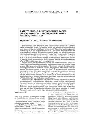
  • 3. H. Justwan et al. 243 2°00' 3°00' 30/10 Utsira Stord 30/11 30/12 31/10 31/11 Viking Graben High Basin Bjørgvin 3/28 3/29 3/30 Fensal Arch 1 Tertiary Frigg Sub-basin Ridge Cretaceous ssic 60°00' 9/3 9/4 9/5 25/1 25/2 25/3 26/1 26/2 a East 1 er Jur 10 12 Upp Shetland Schematic SW-NE Cross-section Platform 9/8 9/9 9/10 A’ A 14 25/4 25/5 25/6 26/4 26/5 Heimdal 2 9/13 9/14 9/15 High Heimdal 1 Stord 1 Terrace Basin 1 2 3 Bergen 1 60 oN 9/18 9/19 24/9 25/7 eridian 25/8 25/9 26/7 26/8 7 Norway 5S 1 Prime M Vana Sub-basin Stavanger 9/23 9/24 1 2 A’ 24/12 25/10 25/11 25/12 26/10 26/11 Study 9/28 15 Area 1R 6S Utsira High Denmark 8A 17 59°00' 55 oN 16/3 15/3 2 16/1 16/2 16/3 17/1 17/2 2 3 Gudrun Patch Bank Ridge U.K. A 1S Terrace 16/8 3 1 5 15/6 16/4 16/5 16/6 17/4 17/5 3 15/5 16/13 2 1 7 2 8S 15/8 15/9 16/7 16/8 16/9 17/7 17/8 3 2 11 2 Cretaceous Basin 1 18 Ling 16/18 Sleipner Sele High Depression Pre-Jurassic Basin 16/23 Terrace Terrace, Intra-basinal High 15/12 16/10 16/11 16/12 17/10 17/11 11S 3 16/28 16/29 2 Platform, High 2 4 10S 0 10 20 30 40 50 58°00' km 2°00' 3°00' Fig.1. General map of the South Viking Graben showing major structural elements (after Norwegian Petroleum Directorate, 2005) and the location of the wells used in quantitative source rock mapping. The schematic SW-NE cross-section (after Isaksen and Ledje, 2001) displays the structure of the South Viking Graben, the flanking highs and the adjacent Stord Basin (line of section A-A’ in main map). The location of the study area in the North Sea is shown in the overview map (lower right). TOC values of up to 80 wt % and Hydrogen Indices water column, whose deposition was terminated by up to 400 g HC/kg Corg (Isaksen et al., 2002). Shales increasing oxygenation accompanying a progressive and grey silty mudstones of the Callovian to Oxfordian transgression. Heather Formation have average TOC values up to The Heather Formation is diachronously overlain 4% (Goff, 1983; Cooper and Barnard, 1984; Field, by the Oxfordian to Ryazanian (Kimmeridge Clay 1985; Thomas et al., 1985). It is generally thought Equivalent) Draupne Formation (Vollset and Doré, that this formation is a lean dry gas source, although 1984) (Fig. 2). Various depositional models for this it shows large variations in source potential and has unit have been put forward (e.g. Hallam and good hydrocarbon potential in some small sub-basins Bradshaw, 1979; Tyson et al., 1979; Demaison and (Cooper and Barnard, 1984; Field, 1985; Thomas et Moore, 1980; Parrish and Curtis, 1982; Oschmann, al., 1985; Scotchman, 1991; Gormly et al., 1994; 1988; Miller, 1990). The well studied onshore Isaksen et al., 2002). Thomas et al. (1985) described outcrops are however not easily comparable in age or a widespread basal-Heather “hot shale” deposited facies with the offshore equivalent (Wignall, 1994). under dysoxic to anoxic conditions beneath a stratified It is generally agreed that deposition of the offshore
  • 4. 244 Late to Middle Jurassic source facies and quality variations, South Viking Graben, North Sea Rel.Sea Age Gen. Lithostratigraphy Major Events Level* (after Hardenbol et al. Seq. (after Doré et al. 1985; Thomas et al. (after Rawson & Riley 1982; Cockings et al.1992; Cornford, 1998; Fraser et al. 2003) 1998) 1985; Cockings et al.1992; Fraser High Low Ma * W et al. 2003) E Cretaceous Late -Basin flushing in Late Ryazanian ends Draupne deposition Ryazanian -Thermal subsidence prevails E Upper Draupne -No active fan systems 140 Early Formation -Upper Draupne deposited as draping post-rift clay layer Late Intra-Draupne -Only minor extension, thermal subsidence dominates, onset of post-rift sands phase, abandonment of fan systems Middle D Transition syn- to post-rift Lower Draupne Volgian Formation -Deep water fan systems become very abundant and prograde eastwards from Utsira High East Shetland Platform, also sand input from Utsira High Early C -Deposition of Lower Draupne Formation with widespread change to dysoxic Intra-Draupne facies 150 sands Kimmeridgian Upper -Intensification of rifting activity Jurassic Lower -Active fan systems sourced from Utsira High and East Shetland Platform B Upper Oxfordian Heather Formation Middle A -Accelerated rifting and deepening Lower Intra-Heather sands 160 Upper Callovian -Continuing southward transgression of Boreal sea along graben axis gives rise n Middle io to deposition of Heather shales at rm Fo Pre A Lower n -Deposition of coastal plain sediments including sands, coals and coaly shales of gi Hu the Sleipner Formation and nearshore sands to coastal plain deposits of the Hugin Formation Bathonian Upper Sleipner Formation Middle Lower *Relative sea-level and genetic sequences after Fraser et. al (2003) Fig. 2. General stratigraphic chart of the Upper to Middle Jurassic succession in the South Viking Graben with a summary of the major tectonic and depositional events. The Oxfordian to Kimmeridgian Draupne Formation can be divided into an upper post-rift section including genetic sequences D and E (Fraser et al., 2003) and a lower syn-rift section. The Draupne and Heather Formation contain a series of sands sourced from the flanking highs, the East Shetland Platform and the Utsira High. Kimmeridge Clay occurred in a shallow sea with anoxic 2003). The upper and lower parts of the Draupne bottom waters (Cornford, 1998), although the degree Formation were therefore considered separately in of oxygenation appears to decrease from the lower to the present study. the upper Draupne Formation (Thomas et al., 1985; In general, these sections correspond to post- and Justwan and Dahl, 2005). The Draupne Formation has syn-rift successions although the identification of TOC up to 12 wt% (Thomas et al., 1985) and Hydrogen these intervals is difficult in the study area Indices which are well over 600 g HC/kg C org. (Gabrielsen et al., 2001; see also Rawson and Riley, However, the formation has large lateral and vertical 1982; and Rattey and Hayward, 1993). For this study, variations in source quality (Field, 1985; Huc et al., the base of the J70 sequence of Rattey and Hayward 1985; Scotchman, 1991; Cooper et al., 1993; Isaksen (1993) was chosen as the base of the post-rift section. and Ledje, 2001; Kubala et al. 2003), especially in the This corresponds to the base of genetic sequence D narrow South Viking Graben whose fringing land areas of Middle Volgian age of Fraser et al. (2003), and were the source of terrestrial organic matter. It has been the Ti5 sequence boundary of Jacquin et al. (1998) observed not only that the terrestrial contribution (Fig. 2). Gamma-ray log pattern and geochemical data decreases upwards (Huc et al., 1985), but also that there were utilized in addition (see below). The lowermost is a distinct difference in source facies and potential section of the syn-rift lower Draupne Formation was between the upper and lower parts of the formation. deposited during intensifying rift activity and rising Thus, the upper section has better source quality and relative sea level (genetic sequence B, see Fig. 2) richness, while the lower part has a higher content of with fan systems shedding sands from the surround- Type III kerogen (Field, 1985; Huc et al., 1985; Isaksen ing highs. The South Viking Graben contains a series and Ledje, 2001; Isaksen et al., 2002; Kubala et al., of these basinward-thinning and -fining sandy
  • 5. H. Justwan et al. 245 wedges of Kimmeridgian to Volgian age (Thomas et GC-MS data (26 wells) and isotope data (21 wells) al., 1985; Sneider et al., 1995; Underhill, 1998; obtained from the Norwegian Petroleum Directorate, Isaksen and Ledje, 2001) which are interpreted to be Esso Exploration and Production A/S Norway or proximal deep-water slope apron complexes sourced previous projects at the University of Bergen were from the East Shetland Platform and the Utsira High also used. (Underhill, 1998; Fraser et al., 2003). They contain Solvent extraction was carried out with a SOXTEC large amounts of reworked terrestrial organic matter System HT2 1045 extraction unit on washed, crushed (Cooper et al., 1993; Isaksen and Ledje, 2001; Justwan and ground cutting samples with dichloromethane/ and Dahl, 2005). Rifting intensified in the Early methanol (93:7) as solvent. The asphaltene fraction Volgian and widespread dysoxic conditions were of all samples was precipitated by adding an excess established (Fraser et al., 2003). A regressive episode amount of n-pentane, following the procedure followed in the Middle Volgian while fan deposition suggested in Weiss et al. (2000). For GC, GC-MS and continued. isotope analysis, preparative group-type separation of The upper Draupne Formation represents a clay the maltene fraction was carried out using medium layer deposited during thermal subsidence after the pressure liquid chromatography (MPLC) following cessation of rifting. Its lowermost section was methods modified from Radke et al. (1980). The deposited during the late Middle Volgian when fan carbon isotopic analysis of the saturate and aromatic systems became less common. The uppermost section, fractions was carried out on a Carlo Erba NA 1500 corresponding to genetic sequence E of Fraser et al. elementary analyser and a Finnigan MAT Delta E (2003), does not show the influence of fans (Fig.2). online mass spectrometer. All results are reported Mass flows from surrounding highs therefore had against PDB. The saturate hydrocarbon fraction of much less of an influence in the upper Draupne extracts of all source rock samples from wells 15/9- Formation. 18, 25/5-5, 25/7-2, 16/7-2 and 25/1-10 were analysed In general, areas surrounding highs and close to using a Hewlett Packard GC-MSD, consisting of a the palaeo-shoreline were dominated by the deposition HP 6890 GC Plus, a HP 5973 Mass Selective Detector of Type III and IV organic matter (Thomas et al., 1985; operating in SIM mode at the University of Bergen. Cooper et al., 1993; Kubala et al., 2003). The deep, The GC unit was equipped with two HP 19091Z-105 basinal sections are richest in Type II organic matter HP-1 methyl siloxane columns each of 50 m nominal (Thomas et al., 1985; Miller, 1990; Cornford, 1998), length, 200 µm nominal diameter and 0.33 µm with a typical concentric, outward-decreasing TOC nominal film thickness. The oven’s initial temperature distribution (Huc, 1988; Cooper et al., 1993). was 50°C and increased regularly during 20 minutes Although the basinal sections are generally oil prone, to an end temperature of 310°C until 80 minutes. they can potentially contain large amounts of inertinite Helium was used as the carrier gas. The temperature transported by mass flow processes (Tyson, 1989; of the FID was 320°C and the hydrogen flow was 40 Thomas et al., 1985). Below, using recently-acquired ml/min, while the airflow was held at 400 ml/min. data, we investigate if these general assumptions are The saturate hydrocarbon fractions of samples still applicable to the South Viking Graben, and from wells 15/3-3, 15/3-5 and 16/1-2 (location see attempt to determine the controls on the distribution Fig.1) were analysed on the same system, but using of organic facies in this area. two HP 19091J-102 HP-5 5% phenyl methyl siloxane columns of 25 m nominal length. The oven’s initial SAMPLES, DATA, ANALYTICAL METHODS temperature was 70°C, increased during 20 minutes to an end temperature of 310°C until 60 minutes, and A large Rock-Eval database was available comprising the airflow was held at 450 ml/min. GC and GCMS samples from 47 wells in the study area, of which ratios were calculated from measured peak heights. eight where analysed during this project using a Vinci For all analyses performed, standards were run every Technologies Rock-Eval 6 in bulk rock mode. The tenth sample to ensure analytical quality and remaining data is derived from geochemical service comparability of results. reports publicly available from the Norwegian Petroleum Directorate or were provided by Esso RESULTS AND DISCUSSION Norway. Cuttings provided by the Norwegian Petroleum Directorate for this project from the source Thickness, areal extent and accumulation rates rock sections of eight wells were analysed by gas of the Upper Jurassic source rock intervals chromatography (GC) and gas chromatography-mass For basin modelling, the quality and potential of the spectrometry (GC-MS). In addition, the isotopic source rock as well as the thickness of the respective composition of 15 samples from well 15/9-18 were source intervals should be investigated. To produce analysed. Vitrinite reflectance data (36 wells), GC and isochore maps of the upper Draupne, lower Draupne