Term i 2° - social studies 2018
•Download as DOCX, PDF•
1 like•483 views

Social Studies 2° Term I 2018

Recommended
More Related Content
Similar to Term i 2° - social studies 2018
Similar to Term i 2° - social studies 2018 (20)
More from Daniela Paris
More from Daniela Paris (13)
Recently uploaded
Recently uploaded (20)
Term i 2° - social studies 2018
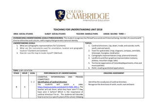
- 1. TEACHING FOR UNDERSTANDING UNIT 2018 AREA: SOCIAL STUDIES SUBJET: SOCIALSTUDIES TEACHER: DANIELA PARIS GRADE: SECOND TERM: I OVERARCHING UNDERSTANDING GOALS(THROUGHLINES): The studentrecognizes her/himself asasocial and historical being,memberof acountrywith diverse ethnicitiesandcultures,withalegacythatgeneratesnational identity. UNDERSTANDING GOALS: 1. What are cartographic representations for? (Content). 2. What are the instruments used for orientation, location and geographic location? (Content and Content) 3. How do I use the map to locate myself? (Method). TOPICS: 1. Cardinal directions.(Up,down,inside,andoutside,north, south,eastand west). 2. Toolsfor spatial data (map,diagrams,compass,astrolabe, telescope,hourglass,landmarks) 3. Cartographicrepresentations(map,planeandstreets). 4. Landformsandtheirgraphical representation(volcano, plateau,mountainrange,lake). 5. Territorial organizationof Colombia(departments,citiesand municipalities) 6. PLEA´s readingworksheetapplications TOPIC 1 MY LOCATION STAGE HOUR GOAL PERFORMANCES OF UNDERSTANDING ONGOING ASSESSMENT E 4 1 - 2 COGNITIVE, INTERPERSONAL AND PROCESS COMPETENCE Identification of cardinal direction The students will watch a video https://www.youtube.com/watch?v=f2I81_BFb-s. The teacher will ask them: what they have seen? If they have seen it before? Which is the importance of cardinal direction? So on. The students will describe howtoarrive toa specificplace of the school,following - Identifiesthe vocabularyof cardinal direction. - Recognize the directionsof north,south,eastandwest.
- 2. 1-3 the instructionsgiven. Studentswill workingroupsand give directionstotheirpartnerstoarrive tothe library, restaurant, park, and other places in the school. COGNITIVE, INTERPERSONAL COMPETENCE Creation of classroom map The students will give cardinal directions to help the teachertolocate the differentobjectsinthe classroom (door,window,table,desk,chairsandboard) onamap. Locate on the map where the sun rises, north, south, east and west. - Transfersthe physical positiontoapositiononthe map. - Uses cardinal directiontolocate anobjectonthe map. - Identifieswhere the sunrise. G 8 2 1 1 COGNITIVE AND INTERPERSONAL COMPETENCE Comparison of tool for geospatial data Studentswillcompare thedifferentusesof eachtoolto determine in which situations each of these tools is best. Through a video where someone looks for the way and making comparisons with the different destinations and the video. The students will draw the different tools and write each description. PROCESS COMPETENCE Recognition of landforms Studentswill recognize the differentsilhouettesof the surface.Toassociate the different landformswiththeir geographical expressions through a worksheet and socialization with their partners. COGNITIVE COMPETENCE Illustration of cartographic representation Students will contrast the different cartographic representations to create a mind map through socialization. - Uses previousknowledge (cardinal directionsandmaps) to describe toolsforgeospatial data. - Identifiesthe compass,GPSandclockas toolsfor spatial - Describe howtouse the correct tool. - Matches the picturesof landformstothe correct word. - Synthesizesthe functionof mapsandlandmarksasa graphical representationof aplace.
- 3. 1-2-3 COGNITIVE AND INTERPERSONAL COMPETENCE Design the best way In groups, students will recognize the best way to get from one point to another on the map to practice the cardinal directionsthrough the use of the map and the best guide tool. - Proposesdifferentwaystoarrive to one place to another. - Uses the cardinal direction. S 2 1-2-3 COGNITIVE COMPETENCE - PROCESS COMPETENCE – INTERPERSONAL COMPETENCE Creation of a Map The students will create and present a map with landforms. The students will be divided in groups and each group is going to model a landform. - Combines the different landforms in a logical way. - Recognizes and uses properly vocabulary related to cardinal direction, tools for spatial data, cartographic representationand landforms. TOPIC 2: HOW IS THE PLACE WHERE I LIVE? E 6 1 1 3 COGNITIVE COMPETENCE Identification of a landform The students will watch a video about landforms identifyingeachone.Then,theymatchseveral pictures about landformsthatthe teachergivesthem,withthe appropriate word. Finally, they will colored the pictures. COGNITIVE COMPETENCE Classification of landforms and bodies of water The students will classify the differences between landforms and bodies of water, to establish their characteristics through a chart. INTRAPERSONAL AND PROCESS COMPETENCE Identification of the Colombian map The students will be divided in groups to find out the location of Colombia on the map using a text where they are given hints related to the vocabulary seen in class. Distinguishes specific characteristics of landforms. Explains: what is a landform? Classifies properly landforms and bodies of water. Recognizes Colombia on the map. Uses properly vocabulary related to cardinal directions and tools for spatial data.
- 4. 1-3 INTRAPERSONAL COMPETENCE Socialization of different places they have visited in Colombia The students will share with their partners the places theyknowor have heard inColombia,sharingalsothe landforms, landscapes, temperatures, activities in everyplace.Teacherhas to guide themwithquestions like,Canyouski there?DoyouthinkthatColombiahas deserts? In order to recognize the diversity of the country.Finally,the studentswill drawthree examples of landscapes that we can find in Colombia. Identifies the landforms in places they have been. Relatesthe landformswiththe commonactivitiesdevelopedinthere. G 10 1 3 1-3 CONGNITIVE AND PROCESS COMPETENCE 1. Description of how a landforms is created The studentswillrecognizethe differentlandformsand comprehend how they are formed through a video. https://youtu.be/G5Rp9MJJGCU CONGNITIVE AND INTRAPERSONAL COMPETENCE 2. Recognition of Landforms in Colombia The students will recognize where the different types of landforms are locate in Colombian map through a puzzle using the draws of landforms made in the socialization activity. INTRAPERSONAL AND COGNITIVE COMPETENCE 3. Identification of the 32 departments The students will locate the departments through a giant puzzle on the board that they have to solve with the teacher guide. https://mapasinteractivos.didactalia.net/comunidad/ mapasflashinteractivos/recurso/departamentos-de- colombia/fd16194c-8dbd-4dc2-8a48-fa8e64ea9c00 HOMEWORK - Discoversthe difference betweenalandformand a humanmade form (buildings, machines, landscapes) - Classifies in order the erosion process. - Identifiestheelements(water,wind,ice)of nature involvedinthe creation of landforms. - Recalls information given in previous classes about landforms in Colombia. - Recognizes the different location of landforms in Colombia. - Recognizes most departments of Colombia.
- 5. Type of homework: Comprehension Goal: Use the vocabulary learned to talk about a department chosen at random. Instructions: Prepare a short presentation about one departmentthe departmentthatwasassignedtoeach student. Assessment criteria: Oral presentation prepared in advance (no reading) and punctuality. S 4 1 1-2-3 COGNITIVE AND INTERPERSONAL COMPETENCE Completing a Colombia map with departments The students will build a puzzle of Colombia to relate the departments and the location. Organizes the map of Colombia properly. Matches the departments with their location. Relates each department with its respective city. TOTAL 32 DESCRIPTORES TRIMESTRE: SUPERIOR ALTO BÁSICO BAJO The students applies the concepts worked to recognize him/her as a member of a regional group and nation. Furthermore, explains and contrasts the origin of the different landforms and their graphic representation. The studentdescribeswithdetail the concepts worked to recognize him/her as a member of a regional group and nation. Furthermore, comparesandidentifiesthedifferent landforms, their origin, and their graphic representation. The students mentions some characteristics of the concepts worked to recognize him/her as a member of a regional group and nation. Also, recognizes the some landforms their origin, and their graphic representation. The student has trouble identifying the concepts worked, such as the elements as member of regional group and a nation, the different landforms, their origin, and their graphic representation.
- 6. CRITERIA LEVELS Superior High Basic Low Oral presentations (Synthesis stage) The studentalwaysusesthe target language to talk about the different topics worked in class. The student uses very often the target language to talk about the different topics worked in class. The studentsometimesuses the target language to talk about the different topics worked in class. The student rarely uses the target language to talk about the different topics worked in class. Written activities The studentworksinan excellentwaythe activities inand out of the class, usingthe targetlanguage, showsresponsibilityfor givingcompromisesand homeworkinthe assigned time,andworksshow qualityandeffort. The studentdoesthe activitiesinside andoutside the class,usingthe target language andshowing responsibilityandtriesto give the workson time. The studentsolvesthe activitiesinandoutthe class;givesthe works,but sometimesafterthe establisheddate. The studentworksinclass but needsmore effortin the activitiesdone.He/she mustpay more attentionto the instructionsanddates for work’spresentation.
- 7. PERFORMANCE RIBRIC: CRITERIA LEVELS Superior High Basic Low Preparation and Presentation The student always willing and focused during group work and presentation. The student usually willing and focused during group work and presentation. The student sometimes willing and focused during group work and presentation. The student rarely willing and focused during group work and presentation. Use of Non-Verbal Cues (voice, gestures, costumes) The studentusesimpressive varietyof non-verbalcuesin an exemplary way. The student uses good variety of non-verbal cues in a competent way. The student uses satisfactory variety of non- verbal cuesinan acceptable way. The studentused limited varietyof non-verbal cues ina developingway. Use of language The studenttalksaboutthe differentfestivalsworked, explainingrepresentative characters,food,musicand instruments,withno assistance fromthe teacher. The student talks about some festivals worked, explaining representative characters, food, music and instruments with minimal assistance fromthe teacher. The studenttalksaboutfew festivalsworked,explaining representative characters, food,musicand instrumentswithcontinued assistance fromthe teacher. The studenthas difficulties to expresshim/herselfor answersome questions usingthe vocabulary studiedduringthe term.