
Recommended
More Related Content
Viewers also liked
Viewers also liked (20)
Similar to Steps to Citizenship
Similar to Steps to Citizenship (20)
More from Dan NNN
More from Dan NNN (19)
Recently uploaded
Recently uploaded (20)
Steps to Citizenship
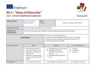
- 1. KA 2 – “Steps of Citizenship” ITALY - ISTITUTO COMPRENSIVO CAMERANO Planning Grid Target students Classes: IIA, IIB, IIC Students aged 13 Time 25 hours January – February –March 2015 Teachers involved Teachers of Italian, Geography, History, English Authentic Task Product/output Realization of the map of the “ideal city” and multimedial presentation of the activitites. COMPETENCES To acquire and to interpet information To research, gather and elaborate datas, information and concepts To build presentations using both traditional instruments and ICT To develop linguistic skills in English Learning objectives Skills Contents Attitude/Behaviour a) Using reading strategies to analyze the content of a text b) searching for information in different texts c) being able to interpret and to compare landscapes and their features a) knowledge of one’s own territory b) knowledge of different landscapes’ features (rural, urban….) c) knowledge if different kinds of maps a) Curiosity b) Cooperation c) Creativity Prerequisites 1) Orientation in one’s own 1) knowledge of a topographic map 1) Being able to cooperate
- 2. town 2) Orientation on a map 3) Creating symbols for a map legend 2) knowledge of what a map legend is 3) knowledge of the meaning of “ideal” 2) Accepting assignments 3) Respect Teacher’s task (and materials/tools used) Students’ task (and materials/tools used) PHASE 1 Time: 2 h Place: classroom Objectives: Interpreting a written document Presentation of the project: name, teachers, subjects involved and duration. -Reading of the text: the students in circle are given the photocopy of the passage “La città e la memoria. Maurilia” ( “City and Memory – Maurilia”) from “Le città invisibili” (“Invisible Cities”, chapter V) by Italo Calvino (an Italian journalist and writer of short stories and novels). The teacher reads the passage. The teacher leads the comprehension of the text and the comments about “Maurilia”, past and present. The teacher leads a short discussion about the changes that have taken place over the years in Camerano. Students listen and read the text. They participate in the discussion about the city described, focusing on the differences between the past Maurilia and the present Maurilia. They talk about their own town and how it has changed over the years. PHASE 2 Time: 2 h Place: classroom Objectives: interpreting iconographic sources The teacher shows paintings of the “ideal city” on the interactive whiteboard, pointing out the author, the historic period and the place they are on display today. The teacher leads a discussion about the understanding of iconographic sources, trying to make students think about the features characterizing the cities of the past, through questions. Iconographic sources: - “Città Ideale” , unknown author , 1480 -1490 Students observe the pictures and reflect on the features about the cities represented (space, background, foreground, types of buildings, people..….).
- 3. (Urbino, National Gallery of Marche); - “Veduta della Città Ideale” (“The Ideal City”, Walters Art Museum of Baltimore); - “Veduta di città ideale” (Berlin Gemaldegalerie) PHASE 3 Time: 1 h Place: classroom Objectives: - interpreting photographs; - comparing; The teacher invites students to search for pictures (internet, family pictures…) of their own town in the present and in the past. The pictures are displayed on the interactive whiteboard and students are asked to compare them. Students compare photos of their own town in the past and in the present and focus on positive and negative aspects both in the past and in the present. PHASE 4 Time: 2h Place: classroom Objectives: - To gather data - To develop critical thinking GROUPWORK The teacher creates the groups and hands out a survey questionnaire about fashionable and unfashionable places in Camerano (i.e. what’s the place you like most for your free time? Which place would you like to have in your town?...) GROUPWORK Each student fills in the questionnaire, explicating the places for an ideal town, and discusses about it within the group. Then each group hands out the survey questionnaire to all the other classes of the institute and results are illustrated through histograms. PHASE 5 Time: 2 hours Objectives: finding out and comparing implicit and explicit information The teacher guides a discussion about the data gathered. Data gathering and results presentation using the Interactive Whiteboard. Within each group students share the data obtained by the class and propose new places for the ideal town on the base of the survey results. PHASE 6 Time: 4h Objectives: GROUPWORK The teacher shows students different kinds of maps and makes them notice the differences. Then the Students, in group, create their own Ideal City indicating on the blank map, through the use of a map legend planned by themselves, the outdoor and indoor
- 4. - To use geographic instruments and language; - orientation in space teacher gives each group a blank topographic map of Camerano and asks students to fill it in with places through the creation of a map legend. places thought in the previous phase. PHASE 7 Time: 2h Place: classroom Objectives: presenting works The teacher guides a discussion about the final outputs. Each group makes a presentation of their own work to the other groups and to all the classes involved in the project. PHASE 8 Time: 10 h Place: computer room Objectives: creating a CD The teacher coordinates the preparation of a multimedial product: presentation/Video Students create a multimedial product: presentation/video EVALUATION TEST Self- evaluation , through a test, to highlight students motivation, their capacity to work in group and the acquired knowledge.