SlideShare a Scribd company logo
1 of 16
Download to read offline
INDIVIDUAL ENVIRONMENTAL RESOURCE PERMIT TECHNICAL STAFF REPORT
22-Aug-2017
APPLICATION #: 21637-3
Applicant: Bryant Smith
City of Winter Springs
1126 E State Road 434
Winter Spgs, FL 32708-2715
(407) 327-8979
Robert Hara
Lake Jesup Woods Partnership
1452 Pelican Bay Trl
Winter Park, FL 32792-6131
(407) 797-8526
Owner: Bryant Smith
City of Winter Springs
1126 E State Road 434
Winter Spgs, FL 32708-2715
(407) 327-8979
Consultant:Allen C Lane, Jr.
CPH, Inc.
1117 E Robinson St
Orlando, FL 32801-2025
(407) 425-0452
Project
Name:
City of Winter Springs - Torcaso Park
Acres
Owned:
27.6
Project
Acreage:
4.66
County: Seminole
STR:
Section(s): Township(s): Range(s):
38 20S 30E
Receiving Water Body:
Name Class
Lake Jesup III Fresh, IW
Authority:
62-330.020 (2)(j), 62-330.020 (2)(b), 62-330.020 (2)(a), 62-330.020
(2)(c) , 62-330.020 (2)(d)
Existing Land Use: Recreational(1800), Mixed Wetland Hardwoods(6170)
Mitigation Drainage Basin: Lake Jesup
Special Regulatory Basin:
Final O&M Entity: City of Winter Springs
ERP Conservation Yes
Easements/Restrictions:
Interested Parties: No
Objectors: No
Authorization Statement:
Modification of Permit 21637-2 for City of Winter Springs - Torcaso Park, a 4.66 - acre project to be
constructed and operated as per plans received by the District on July 25, 2017.
Recommendation: Approval
Reviewers: Ken Lewis; Gary Haddle
Staff Comments
Project Applicant and Sufficient Real Property Interest: Under rule 62-330.060,
Florida Administrative Code (F.A.C.), and subsection 4.2.3(d), Environmental Resource
Permit Applicant’s Handbook Volume I (ERP A.H. Volume I), a permit applicant must
certify that it has sufficient real property interest over the land upon which the activities
subject to the application will be conducted.
The permit applicants are the record title holders.
Project Location and Brief Description:
This project is located at 104 N. Moss Road within the City of Winter Springs, Seminole
County. This application seeks authorization to modify the existing Torcaso Park to
construct new parking lots, drive lanes, and a new building with covered basketball
courts. Demolition and reconstruction of one existing parking lot is also proposed. This
application proposes 0.63 acres of direct wetland impacts, and 0.34 acres of direct
surface water impacts.
Permitting History:
On April 9, 1984, the District issued Management and Storage of Surface Water Permit
4-117-0016G for the extension of Moss Road from State Road 434 to State Road 419
and a 10.5 acre-foot surface water management pond. Construction of this extension
involved work in approximately 0.1 acres of surface waters.
On November 10, 1995, the District issued Permit 40-117-0323G-ERP for construction
of a 4.4-acre Public Safety Facility for the City of Winter Springs. Construction of this
facility involved work in 0.30 acres of surface waters.
On May 6, 2002, the District issued Permit 40-117-21637-2 for modification of an
existing surface water management system, consisting of construction of a city park,
parking lot with driveway, and future parking area and conveyance system. This
construction authorized work in 0.53 acres of man-made surface waters.
Engineering
Description of Project (Surface Water Management System):
The project site consists of an existing City park and wet detention pond, with an
upland-cut drainage ditch that connects to an existing 48" stormwater pipe at Edgemon
Avenue and an existing pipe on the park property.
The applicant proposes to construct new parking lots, drive lanes, and a new building
with covered basketball courts. The applicant also proposes demolition and
reconstruction of one existing parking lot. An new entrance road and sidewalk will be
constructed on fill above the drainage ditch. A new 48" pipe will replace the ditch.
Stormwater runoff from all existing and proposed development will discharge/continue
to discharge to the existing wet detention pond.
Water Quality:
The applicant has submitted plans and calculations demonstrating that the previously
permitted surface water management system, modified as proposed, will continue to
provide treatment and recovery of the required treatment volume for systems that
discharge to a Class III waterbody.
Lake Jesup is a nutrient-impaired waterbody. The existing surface water management
system, modified as proposed, will continue to attenuate the post-development
discharge of nutrients to at or below pre-development levels.
Flood Protection:
The applicant has submitted plans and calculations demonstrating that the previously
permitted surface water management system, modified as proposed, will continue to
provide for attenuation of the peak rate of discharge of stormwater runoff from the 25-
year/24-hour storm event.
Special Basin Criteria:
N/A
Operation and Maintenance:
The permit applicants will be the operation and maintenance entity.
Environmental
Site Description:
The project site consists of an existing City park and wet stormwater pond, including
play fields, paved parking area, various pavilions, splash pad recreation area, and
sidewalks. There is an onsite 0.63-acre wetland (W1), which is a low quality, forested
system connected to the north via an underground culvert pipe. The wetland receives
direct runoff from the adjacent Moss Road, and appears to have distressed hydrologic
conditions as indicated by soil subsidence and treefall. The canopy consists
of sweetbay magnolia, red maple, loblolly bay, slash pine, water oak, sabal palm,
Chinese tallow, chinaberry, and camphor tree, along with a shrub layer of Brazilian
pepper and Peruvian primrosewillow. The project also includes an onsite ditch (SW1)
that is approximately 600-feet long and 25-feet wide (0.34 acre). The ditch is located on
the west side of the project between the existing park and N. Edgemon Avenue and is
regularly mowed and maintained.
Impacts: Subsection 10.2.2, ERP A.H. Volume I, states that an applicant must provide
reasonable assurances that a regulated activity will not impact the values of wetland
and other surface water functions so as to cause adverse impacts to: (a) the abundance
and diversity of fish, wildlife and listed species; and (b) the habitat of fish, wildlife and
listed species.
The proposed project will result in direct impacts to the 0.63-acre wetland W1. In
addition, the 0.34-acre surface water (SW1) will be impacted. Pursuant to 10.2.2.2,
ERP A.H. Volume I, any drainage ditches that were constructed in uplands will not be
required to comply with provisions of subsections 10.2.2-10.2.2.3, 10.2.3-10.2.3.7,
10.2.5-10.3.8., ERP A.H. Volume I. This drainage ditch does not provide significant
habitat for threatened or endangered species, and the impacts are not considered
adverse. Therefore, no elimination or reduction, mitigation or cumulative impacts
analysis will be required for the dredge and fill activities proposed within the drainage
ditch (SW1).
Secondary impacts: Subsection 10.2.7, ERP A.H. Volume I, contains a four-part
criterion that addresses additional impacts that may be caused by a proposed activity:
(a)adverse impacts to wetland (and other surface water) functions and water quality
violations that may result from the intended or reasonably expected uses of a proposed
activity; (b) adverse impacts to the upland nesting habitat of bald eagles and aquatic or
wetland dependent listed animal species; (c) impacts to significant historical and
archaeological resources that are very closely linked and causally related to any
proposed dredging or filling of wetlands or other surface waters; and (d) adverse
wetland (and other surface) impacts and water quality violations that may be caused by
future phases of the project or by activities that are very closely linked and causally
related to the project.
a.) The project is sufficiently distant from offsite wetlands and other surface waters to
ensure that the project will not cause unacceptable adverse secondary impacts to their
functions. The offsite forested wetland that is located north of the onsite ditch to be
filled is a minimum of 25 feet away from the proposed construction. The offsite wetland
is located on City-owned property, and a note on the plans was added which labels the
offsite wetlands and uplands as "Conservation Area No Vegetation Disturbance or
Dumping Allowed", which will ensure that no secondary impacts will occur within this
area.
b.) No listed species are likely to reproduce in uplands near the present project that
could be diminished by the work or future land use.
c.) No adverse, unacceptable impacts to archaeological or historical resources are
anticipated to result from this proposed project, pursuant to Section 10.2.7(d), ERP A.H.
Volume I.
d.) The present project will be authorized entirely by this ERP. Future phases that may
occur will have sufficient uplands available to achieve the project without the need to
impact in additional adverse impacts.
Elimination/Reduction of Impacts: Pursuant to Subsection 10.2.1.1, ERP A.H.
Volume I, the applicant must implement practicable design modifications to reduce or
eliminate adverse impacts to wetlands and other surface waters. A proposed
modification that is not technically capable of being completed, is not economically
viable, or that adversely affects public safety through endangerment of lives or property
is not considered "practicable". Alternatively, an applicant may meet this criterion by
demonstrating compliance with subsection 10.2.1.2.a. or 10.2.1.2.b, ERP A.H. Volume
I.
Elimination or reduction of impacts was not required for the 0.63-acre direct impacts to
W1 because the ecological value of the functions provided by the area of wetland to be
adversely affected is low, and the proposed mitigation will provide greater long term
ecological value than the area of wetland to be adversely affected, pursuant to Section
10.2.1.2(a.) ERP A.H. Volume I.
Mitigation:
As mitigation for the 0.63 acres of adverse direct impacts to W1, the applicant is
proposing to preserve 2.50 acres of wetlands at the Jesup Station Mitigation Tract.
These 2.50 acres of wetlands will be recorded in a conservation easement dedicated to
the District. This 2.50 acre tract will be located within a portion of the 60.3-acre Jesup
Station Mitigation Tract that Lake Jesup Woods Partnership plans on preserving for
future projects/ impacts.
The Jesup Station Mitigation Tract (Mitigation Tract) is located in Seminole County, east
of Design Court and along the southern side of the Seaboard Coastline Railroad right-
of-way in Sanford. The Mitigation Tract is located along the northwestern side of Lake
Jesup. The Mitigation Tract is connected to undeveloped floodplain forest to
the southeast that borders Lake Jesup, some residential development is located to
the east and west of the Mitigation Tract, and the railroad and undeveloped land are
located north of the Mitigation Tract.
The Mitigation Tract is comprised of 15.5 acres of a temperate hardwood upland
community, and 44.8 acres of a wetland forested mixed community. The upland
community provides habitat support to the adjacent wetlands. The upland and wetland
communities are high quality communities with a majority of appropriate and desirable
plant species located within each stratum, and minimal cover of invasive exotic or other
invasive plant species. The proposed Preservation and Management Plan, received as
Exhibit C to the draft Conservation Easement received on June 9, 2017, will ensure this
area will continue to provide these high quality functions in perpetuity.
The Mitigation Tract provides supporting wetland community functions by supplying
food sources, nesting and denning habitat and maintains connectivity of a relatively
large wetland system within the Lake Jesup Basin. Therefore, the proposed project is
consistent with the wetland review criteria in Sections 10.2 - 10.3.8, ERP A.H.
The proposed mitigation will offset the same ecological functions as the wetland to be
impacted, because the proposed mitigation site will provide similar habitat to the
wetlands that will be impacted by this project.
The Lake Jesup Mitigation Tract preservation area was assessed utilizing the Uniform
Mitigation Assessment Method (UMAM), pursuant to Chapter 62-345, F.A.C.
Financial Assurance Mechanism:
No
Off-Site Mitigation:
As mitigation for the 0.63 acres of adverse direct impacts associated with this project,
the applicant is proposing to preserve 2.50 acres of wetlands at the Jesup Station
Mitigation Tract. The 2.50 acre of wetlands will be recorded in a conservation easement
dedicated to the District.
Cumulative Impacts:Subsection 10.2.8, ERP A.H. Volume I, requires applicants to
provide reasonable assurances that their projects will not cause unacceptable
cumulative impacts upon wetlands and other surface waters within the same drainage
basin as the project for which a permit is sought. This analysis considers past, present,
and likely future similar impacts and assumes that reasonably expected future
applications with like impacts will be sought, thus necessitating equitable distribution of
acceptable impacts among future applications. Under section 10.2.8, ERP A.H. Volume,
when an applicant proposes mitigation that offsets a project’s adverse impacts within
the same basin as the impacts, the project does not cause unacceptable cumulative
impacts.
Considering the proposed mitigation plan is located within the Lake Jesup drainage
basin and fully offsets the adverse impacts proposed to wetland functions within the
Lake Jesup Drainage Basin, there will be no unacceptable cumulative impacts, pursuant
to Section 10.2.8, ERP A.H. Volume I.
Wetland Summary Table
City of Winter Springs - Torcaso Park Governmental/Institutional
Total Surface Water, Upland RHPZ and Wetlands in Project Acres
Wetlands 0.630
OSW 0.340
Upland RHPZ 0.000
Total 0.970
Impacts that Require Mitigation
Dredged or Filled 0.630
Total 0.630
Impacts that Require No Mitigation
Dredged or Filled 0.340
Total 0.340
Mitigation
On-Site
Total 0.000
Off-Site
Wetland Preservation 2.500
Total 2.500
Conclusion:
The applicant has provided reasonable assurance that the proposed project meets the
conditions for issuance of permits specified in rules 62-330.301 and 62-330.302, F.A.C.
Conditions
1. All activities shall be implemented following the plans, specifications and
performance criteria approved by this permit. Any deviations must be authorized
in a permit modification in accordance with Rule 62-330.315, F.A.C. Any
deviations that are not so authorized may subject the permittee to enforcement
action and revocation of the permit under Chapter 373, F.S.
2. A complete copy of this permit shall be kept at the work site of the permitted
activity during the construction phase, and shall be available for review at the
work site upon request by the District staff. The permittee shall require the
contractor to review the complete permit prior to beginning construction.
3. Activities shall be conducted in a manner that does not cause or contribute to
violations of state water quality standards. Performance-based erosion and
sediment control best management practices shall be installed immediately prior
to, and be maintained during and after construction as needed, to prevent
adverse impacts to the water resources and adjacent lands. Such practices shall
be in accordance with the State of Florida Erosion and Sediment Control
Designer and Reviewer Manual (Florida Department of Environmental Protection
and Florida Department of Transportation June 2007), and the Florida
Stormwater Erosion and Sedimentation Control Inspector’s Manual (Florida
Department of Environmental Protection, Nonpoint Source Management Section,
Tallahassee, Florida, July 2008), which are both incorporated by reference in
subparagraph 62-330.050(9)(b)5, F.A.C., unless a project-specific erosion and
sediment control plan is approved or other water quality control measures are
required as part of the permit.
4. At least 48 hours prior to beginning the authorized activities, the permittee shall
submit to the District a fully executed Form 62-330.350(1), “Construction
Commencement Notice,”[10-1-13], incorporated by reference herein
(http://www.flrules.org/Gateway/reference.asp?No=Ref-02505), indicating the
expected start and completion dates. A copy of this form may be obtained from
the District, as described in subsection 62-330.010(5), F.A.C. If available, a
District website that fulfills this notification requirement may be used in lieu of the
form.
5. Unless the permit is transferred under Rule 62-330.340, F.A.C., or transferred to
an operating entity under Rule 62-330.310, F.A.C., the permittee is liable to
comply with the plans, terms and conditions of the permit for the life of the project
or activity.
6. Within 30 days after completing construction of the entire project, or any
independent portion of the project, the permittee shall provide the following to the
Agency, as applicable:
a. For an individual, private single-family residential dwelling unit, duplex,
triplex, or quadruplex — “Construction Completion and Inspection
Certification for Activities Associated With a Private Single-Family Dwelling
Unit” [Form 62-330.310(3)]; or
b. For all other activities — “As-Built Certification and Request for
Conversion to Operational Phase” [Form 62-330.310(1)].
c. If available, an Agency website that fulfills this certification requirement
may be used in lieu of the form.
7. If the final operation and maintenance entity is a third party:
a. Prior to sales of any lot or unit served by the activity and within one year of
permit issuance, or within 30 days of as-built certification, whichever comes
first, the permittee shall submit, as applicable, a copy of the operation
and maintenance documents (see sections 12.3 thru 12.3.3 of Volume I) as
filed with the Department of State, Division of Corporations and a copy of
any easement, plat, or deed restriction needed to operate or maintain the
project, as recorded with the Clerk of the Court in the County in which the
activity is located.
b. Within 30 days of submittal of the as- built certification, the permittee shall
submit “Request for Transfer of Environmental Resource Permit to the
Perpetual Operation Entity” [Form 62-330.310(2)] to transfer the permit to
the operation and maintenance entity, along with the documentation
requested in the form. If available, an Agency website that fulfills this transfer
requirement may be used in lieu of the form.
8. The permittee shall notify the District in writing of changes required by any other
regulatory District that require changes to the permitted activity, and any required
modification of this permit must be obtained prior to implementing the changes.
9. This permit does not:
a. Convey to the permittee any property rights or privileges, or any other
rights or privileges other than those specified herein or in Chapter 62-330,
F.A.C.;
b. Convey to the permittee or create in the permittee any interest in real
property;
c. Relieve the permittee from the need to obtain and comply with any other
required federal, state, and local authorization, law, rule, or ordinance; or
d. Authorize any entrance upon or work on property that is not owned, held
in easement, or controlled by the permittee.
10.Prior to conducting any activities on state-owned submerged lands or other lands
of the state, title to which is vested in the Board of Trustees of the Internal
Improvement Trust Fund, the permittee must receive all necessary approvals and
authorizations under Chapters 253 and 258, F.S. Written authorization that
requires formal execution by the Board of Trustees of the Internal Improvement
Trust Fund shall not be considered received until it has been fully executed.
11.The permittee shall hold and save the District harmless from any and all
damages, claims, or liabilities that may arise by reason of the construction,
alteration, operation, maintenance, removal, abandonment or use of any project
authorized by the permit.
12.The permittee shall notify the District in writing:
a. Immediately if any previously submitted information is discovered to be
inaccurate; and
b. Within 30 days of any conveyance or division of ownership or control of
the property or the system, other than conveyance via a long-term lease, and
the new owner shall request transfer of the permit in accordance with
Rule 62-330.340, F.A.C. This does not apply to the sale of lots or units in
residential or commercial subdivisions or condominiums where the
stormwater management system has been completed and converted to the
operation phase.
13.Upon reasonable notice to the permittee, District staff with proper identification
shall have permission to enter, inspect, sample and test the project or activities to
ensure conformity with the plans and specifications authorized in the permit.
14.If any prehistoric or historic artifacts, such as pottery or ceramics, stone tools or
metal implements, dugout canoes, or any other physical remains that could be
associated with Native American cultures, or early colonial or American
settlement are encountered at any time within the project site area, work
involving subsurface disturbance in the immediate vicinity of such discoveries
shall cease. The permittee or other designee shall contact the Florida
Department of State, Division of Historical Resources, Compliance and Review
Section, at (850) 245-6333 or (800) 847-7278, as well as the appropriate
permitting agency office. Such subsurface work shall not resume without verbal
or written authorization from the Division of Historical Resources. If unmarked
human remains are encountered, all work shall stop immediately and notification
shall be provided in accordance with Section 872.05, F.S.
15.Any delineation of the extent of a wetland or other surface water submitted as
part of the permit application, including plans or other supporting documentation,
shall not be considered binding unless a specific condition of this permit or a
formal determination under Rule 62-330.201, F.A.C., provides otherwise.
16.The permittee shall provide routine maintenance of all components of the
stormwater management system to remove trapped sediments and debris.
Removed materials shall be disposed of in a landfill or other uplands in a manner
that does not require a permit under Chapter 62-330, F.A.C., or cause violations
of state water quality standards.
17.This permit is issued based on the applicant’s submitted information that
reasonably demonstrates that adverse water resource-related impacts will not be
caused by the completed permit activity. If any adverse impacts result, the
District will require the permittee to eliminate the cause, obtain any necessary
permit modification, and take any necessary corrective actions to resolve the
adverse impacts.
18.A Recorded Notice of Environmental Resource Permit may be recorded in the
county public records in accordance with Rule 62-330.090(7), F.A.C. Such notice
is not an encumbrance upon the property.
19.This permit for construction will expire five years from the date of issuance.
20.At a minimum, all retention and detention storage areas must be excavated to
rough grade prior to building construction or placement of impervious surface
within the area to be served by those facilities. To prevent reduction in storage
volume and percolation rates, all accumulated sediment must be removed from
the storage area prior to final grading and stabilization.
21.The operation and maintenance entity shall inspect the stormwater or surface
water management system once within two years after the completion of
construction and every two years thereafter to determine if the system is
functioning as designed and permitted. The operation and maintenance entity
must maintain a record of each required inspection, including the date of the
inspection, the name and contact information of the inspector, and whether the
system was functioning as designed and permitted, and make such record
available for inspection upon request by the District during normal business
hours. If at any time the system is not functioning as designed and permitted,
then within 30 days the entity shall submit a report electronically or in writing to
the District using Form 62-330.311(1), “Operation and Maintenance Inspection
Certification,” describing the remedial actions taken to resolve the failure or
deviation.
22.Deed of Conservation Easement
This permit requires the recording of a conservation easement. Within 30 days of
recording, the permittee shall provide the District with: (a) the original recorded
easement (including exhibits) showing the date it was recorded and the official
records book and page number, (b) a copy of the recorded plat (if applicable), (c)
a surveyor's sketch of the easement area plotted on the appropriate USGS
topographic map, and (d) the original recorded consent and joinder(s) of
mortgagee (if applicable). Before recording them, the permittee shall ensure that
these documents are acceptable to the District as described below.
Description of Conservation Easement Area.
The permittee shall provide to the District for review and written approval a copy
of: (a) the preliminary plat showing the area to be encumbered by the
conservation easement, or (b) a surveyor's sketch and legal description of the
area to be placed under the conservation easement, per the approved mitigation
plan, at least 45 days before (1) dredging, filling, or clearing any wetland or
surface water for which mitigation is required; (2) clearing any upland within a
Riparian Habitat Protection Zone for which mitigation is required; (3) the sale of
any lot or parcel; (4) the recording of the subdivision plat; or (5) use of the
infrastructure for its intended use, whichever occurs first.
If the impacts to an upland within a Riparian Habitat Protection Zone or to a
wetland or surface water for which mitigation is required will occur in discrete
phases, the areas to be preserved to offset such impacts may be placed under
conservation easement in phases such that impacts are offset during each
phase. Such phasing of preservation shall only occur if it has been proposed in
the mitigation plan and approved by the permit, or if it is approved in writing by
the District. A surveyor's sketch and legal description of the area to be placed
under conservation easement during each phase must be submitted in
accordance with the previous paragraph.
Recording of Conservation Easement.
Before (1) dredging, filling, or clearing any wetland or surface water for which
mitigation is required, (2) clearing any upland within a Riparian Habitat Protection
Zone for which mitigation is required, (3) the sale of any lot or parcel, (4) the
recording of the subdivision plat, or (5) use of the infrastructure for its intended
use, whichever occurs first, the permittee shall record a conservation easement.
The conservation easement shall include restrictions on the real property
pursuant to section 704.06, Florida Statutes, and be consistent with section
10.3.8, ERP Applicant's Handbook, Volume I(October 1, 2013) and Fla.
Admin.Code R. 62-330.301(6).
The conservation easement shall be in the form approved in writing by the
District and, if no plat has been submitted, the easement shall include the
approved legal description and surveyor's sketch. If the District does not provide
written comments on the preliminary plat or surveyor's sketch and legal
description within 45 days of receipt, then the permittee may record the
conservation easement with the legal description and surveyor's sketch or plat
reference previously submitted. If the District provides written disapproval of the
preliminary plat or surveyor's sketch and legal description, the permittee shall,
within ten (10) days of receipt of the disapproval, correct all errors with the
conservation easement, including the preliminary plat or legal description and
surveyor's sketch, and record the conservation easement. Pursuant to section
704.06, Florida Statutes, the conservation easement shall prohibit all
construction, including clearing, dredging, or filling, except that which is
specifically authorized by this permit, within the mitigation areas delineated on
the final plans and/or mitigation proposal approved by the District.
The easement may not be amended without written District approval.
Additional Documents Required.
The permittee shall ensure that the conservation easement identifies, and is
executed by, the correct grantor, who must hold sufficient record title to the land
encumbered by the easement. If the easement's grantor is a partnership, the
partnership shall provide to the District a partnership affidavit stating that the
person executing the conservation easement has the legal authority to convey an
interest in the partnership land. If there exist any mortgages on the land, the
permittee shall also have each mortgagee execute a consent and joinder of
mortgagee subordinating the mortgage to the conservation easement. The
consent and joinder of the mortgagee shall be recorded simultaneously with the
conservation easement in the public records of the county where the land is
located. Within 30 days of recording, the permittee shall provide the District with:
(a) the original recorded easement (including exhibits) showing the date it was
recorded and the official records book and page number, (b) a copy of the
recorded plat (if applicable), (c) a surveyor's sketch of the easement area plotted
on the appropriate USGS topographic map, and (d) the original recorded consent
and joinder(s) of mortgagee (if applicable).
Demarcation of Conservation Easement Area. Prior to lot or parcel sales, all
changes in direction of the easement area boundaries must be permanently
monumented above ground on the project site.
23.The proposed project must be constructed and operated as per plans received
by the District on July 25, 2017.
24.This permit authorizes 0.63 acres of adverse direct wetland impacts and 0.34
acres of surface water impacts.
25.This permit requires the recording of 2.50 acres of wetlands into a conservation
easement dedicated to the District. The preservation of wetlands will be located
at the offsite mitigation parcel known as Jesup Station Mitigation Area per the
information received by the District on June 9, 2017.
26.The City of Winter Springs shall be responsible for the operation of the
stormwater management system. Lake Jessup Woods Partnership shall be
responsible for the success of the offsite mitigation area.
27.A maintenance program shall be implemented in accordance with the Basic
Management Plan for Preservation Only Jesup Station Mitigation Tract received
by the District on June 9, 2017, and to be recorded with the
Conservation Easement as Exhibit C, for the preserved wetland area to ensure
that area meets the integrity and viability of the success criteria as permitted,
including ensuring that the mitigation site is maintained in perpetuity free from
invasive exotic species such that they comprise no more than 5 percent cover.
In addition, the permittee shall manage the conservation areas such that
exotic/nuisance plant species do not dominate any one section of those areas.
1 -
Current
w/Impact
Current
w/Impact
Current
w/Impact
Current
w/Impact
MD
Direct
1
W1
df
2
0
2
0
3
0
0.23
0.63
0.147
0.23333
0
0.233333
2
-
-
-
-
-
-
-
-
-
-
-
0
0
-
3
-
-
-
-
-
-
-
-
-
-
-
0
0
-
4
-
-
-
-
-
-
-
-
-
-
-
0
0
-
5
-
-
-
-
-
-
-
-
-
-
-
0
0
-
6
-
-
-
-
-
-
-
-
-
-
-
0
0
-
TOTAL
0.63
0.147
w/o
Mit
w/Mit
w/o
Mit
w/Mit
w/o
Mit
w/Mit
1
W2
Jesup
Station
pres
6
7
8
8
6
8
0.10
1.00
1.00
0.60
0.060
2.50
0.150
2
-
-
-
-
-
-
-
-
-
-
-
-
-
-
-
3
-
-
-
-
-
-
-
-
-
-
-
-
-
-
-
4
-
-
-
-
-
-
-
-
-
-
-
-
-
-
-
5
-
-
-
-
-
-
-
-
-
-
-
-
-
-
-
6
-
-
-
-
-
-
-
-
-
-
-
-
-
-
-
TOTAL
2.50
0.150
Acres
Acres
Acres
0.00
0.00
0.00
0.00
0.00
0.00
Secondary
Impacts
0.00
0.00
0.00
0.00
0.00
0.00
Total
Functional
Loss
0.147
Total
Functional
Gain
0.150
Excess
Mitigation
0.003
Functional
Gain
PAF
Impact
Summary
Functional
Loss
Water
Environment
Mitigation
Type
RFG
Acres
Enhancement
Community
Structure
Restoration
Direct
Impacts
Enhancement
Location
and
Landscape
Support
Acres
Total
Impacts
Total
Upland
Mitigation
Torcaso
Park
Final
UMAM
Community
Structure
Water
Environment
Restoration
Mitigation
Summary
Assessment
Area
Impact
Type
Location
and
Landscape
Support
Mitigation
Delta
Impacts
Time
Lag
MODIFIABLE
SUMMARY
TABLE
Application
Number:
Date:
IND-117-21637-3
August
1,
2017
Site/Project
Name:
Impact
Delta
Mitigation
-
Upland
Assessment
Area
Mitigation
-
Wetland
Creation
Risk
TOTALS
Preservation
Total
Wetland
Mitigation
Preservation

More Related Content

Similar to City of Winter Springs Mitigation Credits Purchase

Heal The Bay - Draft Environmental Impact Report Comments - Hermosa Beach Oil...
Heal The Bay - Draft Environmental Impact Report Comments - Hermosa Beach Oil...Heal The Bay - Draft Environmental Impact Report Comments - Hermosa Beach Oil...
Heal The Bay - Draft Environmental Impact Report Comments - Hermosa Beach Oil...StopHermosaBeachOil
 
Preliminary_Design_Report_Upper_Fintry_Valley_of_the_Sun___TRUE_2010.pdf
Preliminary_Design_Report_Upper_Fintry_Valley_of_the_Sun___TRUE_2010.pdfPreliminary_Design_Report_Upper_Fintry_Valley_of_the_Sun___TRUE_2010.pdf
Preliminary_Design_Report_Upper_Fintry_Valley_of_the_Sun___TRUE_2010.pdfBappy114
 
Positive Declaration for Pilgrim Pipeline from NY DEC & Thruway Authority
Positive Declaration for Pilgrim Pipeline from NY DEC & Thruway AuthorityPositive Declaration for Pilgrim Pipeline from NY DEC & Thruway Authority
Positive Declaration for Pilgrim Pipeline from NY DEC & Thruway AuthorityMarcellus Drilling News
 
Northampton Landfill Waiver from DEP 06-23-2006
Northampton Landfill Waiver from DEP 06-23-2006Northampton Landfill Waiver from DEP 06-23-2006
Northampton Landfill Waiver from DEP 06-23-2006Adam Cohen
 
Presentation-Orange-County-Great-Park-Storm-Water-Reuse-Pond-System-June-2014
Presentation-Orange-County-Great-Park-Storm-Water-Reuse-Pond-System-June-2014Presentation-Orange-County-Great-Park-Storm-Water-Reuse-Pond-System-June-2014
Presentation-Orange-County-Great-Park-Storm-Water-Reuse-Pond-System-June-2014Joseph Merzlak
 
General Water Permit - Ed Puchi
General Water Permit - Ed PuchiGeneral Water Permit - Ed Puchi
General Water Permit - Ed PuchiAGC of California
 
DRBC Docket: XTO Energy Application to Withdraw Surface Water at Oquaga Creek
DRBC Docket: XTO Energy Application to Withdraw Surface Water at Oquaga CreekDRBC Docket: XTO Energy Application to Withdraw Surface Water at Oquaga Creek
DRBC Docket: XTO Energy Application to Withdraw Surface Water at Oquaga CreekMarcellus Drilling News
 
New Construction Stormwater Regulation in Minnesota
New Construction Stormwater Regulation in MinnesotaNew Construction Stormwater Regulation in Minnesota
New Construction Stormwater Regulation in MinnesotaDan Schleck
 
PM.10-EXAMPLE-River Stabilization-Final Plan
PM.10-EXAMPLE-River Stabilization-Final PlanPM.10-EXAMPLE-River Stabilization-Final Plan
PM.10-EXAMPLE-River Stabilization-Final PlanPhilip Martinson
 
Elgin Country Estate Project Summary as on 20160606
Elgin Country Estate Project Summary as on 20160606 Elgin Country Estate Project Summary as on 20160606
Elgin Country Estate Project Summary as on 20160606 John M Riggs
 
Tuskawilla Crossings Pond Berm Failure
Tuskawilla Crossings Pond Berm FailureTuskawilla Crossings Pond Berm Failure
Tuskawilla Crossings Pond Berm FailureVictoriaColangelo
 
Flatlick Branch Phase II Stream Restoration Project
Flatlick Branch Phase II Stream Restoration ProjectFlatlick Branch Phase II Stream Restoration Project
Flatlick Branch Phase II Stream Restoration ProjectFairfax County
 
Environmentally sensitive areas
Environmentally sensitive areasEnvironmentally sensitive areas
Environmentally sensitive areasgscplanning
 
SFPUC PEA_LandUseRec&AgPgs1-9
SFPUC PEA_LandUseRec&AgPgs1-9SFPUC PEA_LandUseRec&AgPgs1-9
SFPUC PEA_LandUseRec&AgPgs1-9Andrew Ackerman
 
Mountain Valley Pipeline, Analysis of Environmental Issues
Mountain Valley Pipeline, Analysis of Environmental IssuesMountain Valley Pipeline, Analysis of Environmental Issues
Mountain Valley Pipeline, Analysis of Environmental IssuesJacqueline Tkac
 
Missouri summary ndaa
Missouri summary ndaaMissouri summary ndaa
Missouri summary ndaaJim Werner
 

Similar to City of Winter Springs Mitigation Credits Purchase (20)

Heal The Bay - Draft Environmental Impact Report Comments - Hermosa Beach Oil...
Heal The Bay - Draft Environmental Impact Report Comments - Hermosa Beach Oil...Heal The Bay - Draft Environmental Impact Report Comments - Hermosa Beach Oil...
Heal The Bay - Draft Environmental Impact Report Comments - Hermosa Beach Oil...
 
Preliminary_Design_Report_Upper_Fintry_Valley_of_the_Sun___TRUE_2010.pdf
Preliminary_Design_Report_Upper_Fintry_Valley_of_the_Sun___TRUE_2010.pdfPreliminary_Design_Report_Upper_Fintry_Valley_of_the_Sun___TRUE_2010.pdf
Preliminary_Design_Report_Upper_Fintry_Valley_of_the_Sun___TRUE_2010.pdf
 
Positive Declaration for Pilgrim Pipeline from NY DEC & Thruway Authority
Positive Declaration for Pilgrim Pipeline from NY DEC & Thruway AuthorityPositive Declaration for Pilgrim Pipeline from NY DEC & Thruway Authority
Positive Declaration for Pilgrim Pipeline from NY DEC & Thruway Authority
 
Missouri
MissouriMissouri
Missouri
 
Northampton Landfill Waiver from DEP 06-23-2006
Northampton Landfill Waiver from DEP 06-23-2006Northampton Landfill Waiver from DEP 06-23-2006
Northampton Landfill Waiver from DEP 06-23-2006
 
Presentation-Orange-County-Great-Park-Storm-Water-Reuse-Pond-System-June-2014
Presentation-Orange-County-Great-Park-Storm-Water-Reuse-Pond-System-June-2014Presentation-Orange-County-Great-Park-Storm-Water-Reuse-Pond-System-June-2014
Presentation-Orange-County-Great-Park-Storm-Water-Reuse-Pond-System-June-2014
 
General Water Permit - Ed Puchi
General Water Permit - Ed PuchiGeneral Water Permit - Ed Puchi
General Water Permit - Ed Puchi
 
DRBC Docket: XTO Energy Application to Withdraw Surface Water at Oquaga Creek
DRBC Docket: XTO Energy Application to Withdraw Surface Water at Oquaga CreekDRBC Docket: XTO Energy Application to Withdraw Surface Water at Oquaga Creek
DRBC Docket: XTO Energy Application to Withdraw Surface Water at Oquaga Creek
 
New Construction Stormwater Regulation in Minnesota
New Construction Stormwater Regulation in MinnesotaNew Construction Stormwater Regulation in Minnesota
New Construction Stormwater Regulation in Minnesota
 
Wetlands and Stormwater Management
Wetlands and Stormwater ManagementWetlands and Stormwater Management
Wetlands and Stormwater Management
 
PM.10-EXAMPLE-River Stabilization-Final Plan
PM.10-EXAMPLE-River Stabilization-Final PlanPM.10-EXAMPLE-River Stabilization-Final Plan
PM.10-EXAMPLE-River Stabilization-Final Plan
 
File287
File287File287
File287
 
Elgin Country Estate Project Summary as on 20160606
Elgin Country Estate Project Summary as on 20160606 Elgin Country Estate Project Summary as on 20160606
Elgin Country Estate Project Summary as on 20160606
 
Tuskawilla Crossings Pond Berm Failure
Tuskawilla Crossings Pond Berm FailureTuskawilla Crossings Pond Berm Failure
Tuskawilla Crossings Pond Berm Failure
 
Flatlick Branch Phase II Stream Restoration Project
Flatlick Branch Phase II Stream Restoration ProjectFlatlick Branch Phase II Stream Restoration Project
Flatlick Branch Phase II Stream Restoration Project
 
Environmentally sensitive areas
Environmentally sensitive areasEnvironmentally sensitive areas
Environmentally sensitive areas
 
SFPUC PEA_LandUseRec&AgPgs1-9
SFPUC PEA_LandUseRec&AgPgs1-9SFPUC PEA_LandUseRec&AgPgs1-9
SFPUC PEA_LandUseRec&AgPgs1-9
 
Mountain Valley Pipeline, Analysis of Environmental Issues
Mountain Valley Pipeline, Analysis of Environmental IssuesMountain Valley Pipeline, Analysis of Environmental Issues
Mountain Valley Pipeline, Analysis of Environmental Issues
 
Missouri
MissouriMissouri
Missouri
 
Missouri summary ndaa
Missouri summary ndaaMissouri summary ndaa
Missouri summary ndaa
 

More from VictoriaColangelo

Winter Springs Sediment Removal: A Major Step Forward
Winter Springs Sediment Removal: A Major Step ForwardWinter Springs Sediment Removal: A Major Step Forward
Winter Springs Sediment Removal: A Major Step ForwardVictoriaColangelo
 
Everything Racket Sports LLC Instructor Agreement 2-27-24
Everything Racket Sports LLC Instructor Agreement 2-27-24Everything Racket Sports LLC Instructor Agreement 2-27-24
Everything Racket Sports LLC Instructor Agreement 2-27-24VictoriaColangelo
 
Evolving Visions for the Winter Springs Golf Course Redevelopment: A Retrospe...
Evolving Visions for the Winter Springs Golf Course Redevelopment: A Retrospe...Evolving Visions for the Winter Springs Golf Course Redevelopment: A Retrospe...
Evolving Visions for the Winter Springs Golf Course Redevelopment: A Retrospe...VictoriaColangelo
 
2023 Winter Springs Water and Wastewater Rate Study Presentation
2023 Winter Springs Water and Wastewater Rate Study Presentation2023 Winter Springs Water and Wastewater Rate Study Presentation
2023 Winter Springs Water and Wastewater Rate Study PresentationVictoriaColangelo
 
Central Winds Park Pickleball Instructional Programs Agreement
Central Winds Park Pickleball Instructional Programs AgreementCentral Winds Park Pickleball Instructional Programs Agreement
Central Winds Park Pickleball Instructional Programs AgreementVictoriaColangelo
 
Winter Springs Audited Financial Statements FY22
Winter Springs Audited Financial Statements FY22Winter Springs Audited Financial Statements FY22
Winter Springs Audited Financial Statements FY22VictoriaColangelo
 
City of Winter Springs Pickleball Update Presentation February 11, 2024
City of Winter Springs Pickleball Update Presentation February 11, 2024City of Winter Springs Pickleball Update Presentation February 11, 2024
City of Winter Springs Pickleball Update Presentation February 11, 2024VictoriaColangelo
 
Winter_Springs_Audited_Financial_Statements_FY22
Winter_Springs_Audited_Financial_Statements_FY22Winter_Springs_Audited_Financial_Statements_FY22
Winter_Springs_Audited_Financial_Statements_FY22VictoriaColangelo
 
JLAC Notice of Enforcement January 17, 2024
JLAC Notice of Enforcement January 17, 2024JLAC Notice of Enforcement January 17, 2024
JLAC Notice of Enforcement January 17, 2024VictoriaColangelo
 
New Legislation Enhances Flexibility in Mitigation Banking - SB 1646 Overview
New Legislation Enhances Flexibility in Mitigation Banking - SB 1646 OverviewNew Legislation Enhances Flexibility in Mitigation Banking - SB 1646 Overview
New Legislation Enhances Flexibility in Mitigation Banking - SB 1646 OverviewVictoriaColangelo
 
2024 Florida Legislative Preview: Key Bills Impacting Local Governments
2024 Florida Legislative Preview: Key Bills Impacting Local Governments2024 Florida Legislative Preview: Key Bills Impacting Local Governments
2024 Florida Legislative Preview: Key Bills Impacting Local GovernmentsVictoriaColangelo
 
Design and Construction Services for the East & West Wastewater Treatment Fac...
Design and Construction Services for the East & West Wastewater Treatment Fac...Design and Construction Services for the East & West Wastewater Treatment Fac...
Design and Construction Services for the East & West Wastewater Treatment Fac...VictoriaColangelo
 
Winter Springs 2023 Water and Wastewater Rate Study
Winter Springs 2023 Water and Wastewater Rate StudyWinter Springs 2023 Water and Wastewater Rate Study
Winter Springs 2023 Water and Wastewater Rate StudyVictoriaColangelo
 
Florida's Wetlands House Water Quality, Supply & Treatment Subcommittee
Florida's Wetlands House Water Quality, Supply & Treatment SubcommitteeFlorida's Wetlands House Water Quality, Supply & Treatment Subcommittee
Florida's Wetlands House Water Quality, Supply & Treatment SubcommitteeVictoriaColangelo
 
City of Winter Springs Transmittal Letter and P&T
City of Winter Springs Transmittal Letter and P&TCity of Winter Springs Transmittal Letter and P&T
City of Winter Springs Transmittal Letter and P&TVictoriaColangelo
 
Pulte Homes/Winter Springs Golf Course (Highlands)
Pulte Homes/Winter Springs Golf Course (Highlands) Pulte Homes/Winter Springs Golf Course (Highlands)
Pulte Homes/Winter Springs Golf Course (Highlands) VictoriaColangelo
 
Pre-publication Version of the Final Rule - Amendments to the Revised Definit...
Pre-publication Version of the Final Rule - Amendments to the Revised Definit...Pre-publication Version of the Final Rule - Amendments to the Revised Definit...
Pre-publication Version of the Final Rule - Amendments to the Revised Definit...VictoriaColangelo
 
2023-24 WSHS Student Grade Level Assemblies
2023-24 WSHS Student Grade Level Assemblies 2023-24 WSHS Student Grade Level Assemblies
2023-24 WSHS Student Grade Level Assemblies VictoriaColangelo
 
August 2023 Winter Springs Development Projects Summary
August 2023 Winter Springs Development Projects Summary August 2023 Winter Springs Development Projects Summary
August 2023 Winter Springs Development Projects Summary VictoriaColangelo
 
City of Winter Springs Potable Water System Technical Support August 2023
City of Winter Springs Potable Water System Technical Support August 2023City of Winter Springs Potable Water System Technical Support August 2023
City of Winter Springs Potable Water System Technical Support August 2023VictoriaColangelo
 

More from VictoriaColangelo (20)

Winter Springs Sediment Removal: A Major Step Forward
Winter Springs Sediment Removal: A Major Step ForwardWinter Springs Sediment Removal: A Major Step Forward
Winter Springs Sediment Removal: A Major Step Forward
 
Everything Racket Sports LLC Instructor Agreement 2-27-24
Everything Racket Sports LLC Instructor Agreement 2-27-24Everything Racket Sports LLC Instructor Agreement 2-27-24
Everything Racket Sports LLC Instructor Agreement 2-27-24
 
Evolving Visions for the Winter Springs Golf Course Redevelopment: A Retrospe...
Evolving Visions for the Winter Springs Golf Course Redevelopment: A Retrospe...Evolving Visions for the Winter Springs Golf Course Redevelopment: A Retrospe...
Evolving Visions for the Winter Springs Golf Course Redevelopment: A Retrospe...
 
2023 Winter Springs Water and Wastewater Rate Study Presentation
2023 Winter Springs Water and Wastewater Rate Study Presentation2023 Winter Springs Water and Wastewater Rate Study Presentation
2023 Winter Springs Water and Wastewater Rate Study Presentation
 
Central Winds Park Pickleball Instructional Programs Agreement
Central Winds Park Pickleball Instructional Programs AgreementCentral Winds Park Pickleball Instructional Programs Agreement
Central Winds Park Pickleball Instructional Programs Agreement
 
Winter Springs Audited Financial Statements FY22
Winter Springs Audited Financial Statements FY22Winter Springs Audited Financial Statements FY22
Winter Springs Audited Financial Statements FY22
 
City of Winter Springs Pickleball Update Presentation February 11, 2024
City of Winter Springs Pickleball Update Presentation February 11, 2024City of Winter Springs Pickleball Update Presentation February 11, 2024
City of Winter Springs Pickleball Update Presentation February 11, 2024
 
Winter_Springs_Audited_Financial_Statements_FY22
Winter_Springs_Audited_Financial_Statements_FY22Winter_Springs_Audited_Financial_Statements_FY22
Winter_Springs_Audited_Financial_Statements_FY22
 
JLAC Notice of Enforcement January 17, 2024
JLAC Notice of Enforcement January 17, 2024JLAC Notice of Enforcement January 17, 2024
JLAC Notice of Enforcement January 17, 2024
 
New Legislation Enhances Flexibility in Mitigation Banking - SB 1646 Overview
New Legislation Enhances Flexibility in Mitigation Banking - SB 1646 OverviewNew Legislation Enhances Flexibility in Mitigation Banking - SB 1646 Overview
New Legislation Enhances Flexibility in Mitigation Banking - SB 1646 Overview
 
2024 Florida Legislative Preview: Key Bills Impacting Local Governments
2024 Florida Legislative Preview: Key Bills Impacting Local Governments2024 Florida Legislative Preview: Key Bills Impacting Local Governments
2024 Florida Legislative Preview: Key Bills Impacting Local Governments
 
Design and Construction Services for the East & West Wastewater Treatment Fac...
Design and Construction Services for the East & West Wastewater Treatment Fac...Design and Construction Services for the East & West Wastewater Treatment Fac...
Design and Construction Services for the East & West Wastewater Treatment Fac...
 
Winter Springs 2023 Water and Wastewater Rate Study
Winter Springs 2023 Water and Wastewater Rate StudyWinter Springs 2023 Water and Wastewater Rate Study
Winter Springs 2023 Water and Wastewater Rate Study
 
Florida's Wetlands House Water Quality, Supply & Treatment Subcommittee
Florida's Wetlands House Water Quality, Supply & Treatment SubcommitteeFlorida's Wetlands House Water Quality, Supply & Treatment Subcommittee
Florida's Wetlands House Water Quality, Supply & Treatment Subcommittee
 
City of Winter Springs Transmittal Letter and P&T
City of Winter Springs Transmittal Letter and P&TCity of Winter Springs Transmittal Letter and P&T
City of Winter Springs Transmittal Letter and P&T
 
Pulte Homes/Winter Springs Golf Course (Highlands)
Pulte Homes/Winter Springs Golf Course (Highlands) Pulte Homes/Winter Springs Golf Course (Highlands)
Pulte Homes/Winter Springs Golf Course (Highlands)
 
Pre-publication Version of the Final Rule - Amendments to the Revised Definit...
Pre-publication Version of the Final Rule - Amendments to the Revised Definit...Pre-publication Version of the Final Rule - Amendments to the Revised Definit...
Pre-publication Version of the Final Rule - Amendments to the Revised Definit...
 
2023-24 WSHS Student Grade Level Assemblies
2023-24 WSHS Student Grade Level Assemblies 2023-24 WSHS Student Grade Level Assemblies
2023-24 WSHS Student Grade Level Assemblies
 
August 2023 Winter Springs Development Projects Summary
August 2023 Winter Springs Development Projects Summary August 2023 Winter Springs Development Projects Summary
August 2023 Winter Springs Development Projects Summary
 
City of Winter Springs Potable Water System Technical Support August 2023
City of Winter Springs Potable Water System Technical Support August 2023City of Winter Springs Potable Water System Technical Support August 2023
City of Winter Springs Potable Water System Technical Support August 2023
 

Recently uploaded

Mumbai Call Girls, 💞 Prity 9892124323, Navi Mumbai Call girls
Mumbai Call Girls, 💞  Prity 9892124323, Navi Mumbai Call girlsMumbai Call Girls, 💞  Prity 9892124323, Navi Mumbai Call girls
Mumbai Call Girls, 💞 Prity 9892124323, Navi Mumbai Call girlsPooja Nehwal
 
VIP Call Girls Moti Ganpur ( Hyderabad ) Phone 8250192130 | ₹5k To 25k With R...
VIP Call Girls Moti Ganpur ( Hyderabad ) Phone 8250192130 | ₹5k To 25k With R...VIP Call Girls Moti Ganpur ( Hyderabad ) Phone 8250192130 | ₹5k To 25k With R...
VIP Call Girls Moti Ganpur ( Hyderabad ) Phone 8250192130 | ₹5k To 25k With R...Suhani Kapoor
 
Russian Call Girls Nashik Anjali 7001305949 Independent Escort Service Nashik
Russian Call Girls Nashik Anjali 7001305949 Independent Escort Service NashikRussian Call Girls Nashik Anjali 7001305949 Independent Escort Service Nashik
Russian Call Girls Nashik Anjali 7001305949 Independent Escort Service Nashikranjana rawat
 
Sustainable Clothing Strategies and Challenges
Sustainable Clothing Strategies and ChallengesSustainable Clothing Strategies and Challenges
Sustainable Clothing Strategies and ChallengesDr. Salem Baidas
 
(AISHA) Wagholi Call Girls Just Call 7001035870 [ Cash on Delivery ] Pune Esc...
(AISHA) Wagholi Call Girls Just Call 7001035870 [ Cash on Delivery ] Pune Esc...(AISHA) Wagholi Call Girls Just Call 7001035870 [ Cash on Delivery ] Pune Esc...
(AISHA) Wagholi Call Girls Just Call 7001035870 [ Cash on Delivery ] Pune Esc...ranjana rawat
 
Horizon Net Zero Dawn – keynote slides by Ben Abraham
Horizon Net Zero Dawn – keynote slides by Ben AbrahamHorizon Net Zero Dawn – keynote slides by Ben Abraham
Horizon Net Zero Dawn – keynote slides by Ben Abrahamssuserbb03ff
 
webinaire-green-mirror-episode-2-Smart contracts and virtual purchase agreeme...
webinaire-green-mirror-episode-2-Smart contracts and virtual purchase agreeme...webinaire-green-mirror-episode-2-Smart contracts and virtual purchase agreeme...
webinaire-green-mirror-episode-2-Smart contracts and virtual purchase agreeme...Cluster TWEED
 
VVIP Pune Call Girls Koregaon Park (7001035870) Pune Escorts Nearby with Comp...
VVIP Pune Call Girls Koregaon Park (7001035870) Pune Escorts Nearby with Comp...VVIP Pune Call Girls Koregaon Park (7001035870) Pune Escorts Nearby with Comp...
VVIP Pune Call Girls Koregaon Park (7001035870) Pune Escorts Nearby with Comp...Call Girls in Nagpur High Profile
 
(ANIKA) Call Girls Wagholi ( 7001035870 ) HI-Fi Pune Escorts Service
(ANIKA) Call Girls Wagholi ( 7001035870 ) HI-Fi Pune Escorts Service(ANIKA) Call Girls Wagholi ( 7001035870 ) HI-Fi Pune Escorts Service
(ANIKA) Call Girls Wagholi ( 7001035870 ) HI-Fi Pune Escorts Serviceranjana rawat
 
Call Girl Nagpur Roshni Call 7001035870 Meet With Nagpur Escorts
Call Girl Nagpur Roshni Call 7001035870 Meet With Nagpur EscortsCall Girl Nagpur Roshni Call 7001035870 Meet With Nagpur Escorts
Call Girl Nagpur Roshni Call 7001035870 Meet With Nagpur EscortsCall Girls in Nagpur High Profile
 
Call Girls South Delhi Delhi reach out to us at ☎ 9711199012
Call Girls South Delhi Delhi reach out to us at ☎ 9711199012Call Girls South Delhi Delhi reach out to us at ☎ 9711199012
Call Girls South Delhi Delhi reach out to us at ☎ 9711199012sapnasaifi408
 
9873940964 High Profile Call Girls Delhi |Defence Colony ( MAYA CHOPRA ) DE...
9873940964 High Profile  Call Girls  Delhi |Defence Colony ( MAYA CHOPRA ) DE...9873940964 High Profile  Call Girls  Delhi |Defence Colony ( MAYA CHOPRA ) DE...
9873940964 High Profile Call Girls Delhi |Defence Colony ( MAYA CHOPRA ) DE...Delhi Escorts
 
Hot Call Girls |Delhi |Preet Vihar ☎ 9711199171 Book Your One night Stand
Hot Call Girls |Delhi |Preet Vihar ☎ 9711199171 Book Your One night StandHot Call Girls |Delhi |Preet Vihar ☎ 9711199171 Book Your One night Stand
Hot Call Girls |Delhi |Preet Vihar ☎ 9711199171 Book Your One night Standkumarajju5765
 
Freegle User Survey as visual display - BH
Freegle User Survey as visual display - BHFreegle User Survey as visual display - BH
Freegle User Survey as visual display - BHbill846304
 
(RIYA) Kalyani Nagar Call Girls Just Call 7001035870 [ Cash on Delivery ] Pun...
(RIYA) Kalyani Nagar Call Girls Just Call 7001035870 [ Cash on Delivery ] Pun...(RIYA) Kalyani Nagar Call Girls Just Call 7001035870 [ Cash on Delivery ] Pun...
(RIYA) Kalyani Nagar Call Girls Just Call 7001035870 [ Cash on Delivery ] Pun...ranjana rawat
 
VIP Kolkata Call Girl Kalighat 👉 8250192130 Available With Room
VIP Kolkata Call Girl Kalighat 👉 8250192130  Available With RoomVIP Kolkata Call Girl Kalighat 👉 8250192130  Available With Room
VIP Kolkata Call Girl Kalighat 👉 8250192130 Available With Roomdivyansh0kumar0
 
Call Girls In Okhla DELHI ~9654467111~ Short 1500 Night 6000
Call Girls In Okhla DELHI ~9654467111~ Short 1500 Night 6000Call Girls In Okhla DELHI ~9654467111~ Short 1500 Night 6000
Call Girls In Okhla DELHI ~9654467111~ Short 1500 Night 6000Sapana Sha
 

Recently uploaded (20)

Mumbai Call Girls, 💞 Prity 9892124323, Navi Mumbai Call girls
Mumbai Call Girls, 💞  Prity 9892124323, Navi Mumbai Call girlsMumbai Call Girls, 💞  Prity 9892124323, Navi Mumbai Call girls
Mumbai Call Girls, 💞 Prity 9892124323, Navi Mumbai Call girls
 
VIP Call Girls Moti Ganpur ( Hyderabad ) Phone 8250192130 | ₹5k To 25k With R...
VIP Call Girls Moti Ganpur ( Hyderabad ) Phone 8250192130 | ₹5k To 25k With R...VIP Call Girls Moti Ganpur ( Hyderabad ) Phone 8250192130 | ₹5k To 25k With R...
VIP Call Girls Moti Ganpur ( Hyderabad ) Phone 8250192130 | ₹5k To 25k With R...
 
Russian Call Girls Nashik Anjali 7001305949 Independent Escort Service Nashik
Russian Call Girls Nashik Anjali 7001305949 Independent Escort Service NashikRussian Call Girls Nashik Anjali 7001305949 Independent Escort Service Nashik
Russian Call Girls Nashik Anjali 7001305949 Independent Escort Service Nashik
 
Sustainable Clothing Strategies and Challenges
Sustainable Clothing Strategies and ChallengesSustainable Clothing Strategies and Challenges
Sustainable Clothing Strategies and Challenges
 
(AISHA) Wagholi Call Girls Just Call 7001035870 [ Cash on Delivery ] Pune Esc...
(AISHA) Wagholi Call Girls Just Call 7001035870 [ Cash on Delivery ] Pune Esc...(AISHA) Wagholi Call Girls Just Call 7001035870 [ Cash on Delivery ] Pune Esc...
(AISHA) Wagholi Call Girls Just Call 7001035870 [ Cash on Delivery ] Pune Esc...
 
Horizon Net Zero Dawn – keynote slides by Ben Abraham
Horizon Net Zero Dawn – keynote slides by Ben AbrahamHorizon Net Zero Dawn – keynote slides by Ben Abraham
Horizon Net Zero Dawn – keynote slides by Ben Abraham
 
webinaire-green-mirror-episode-2-Smart contracts and virtual purchase agreeme...
webinaire-green-mirror-episode-2-Smart contracts and virtual purchase agreeme...webinaire-green-mirror-episode-2-Smart contracts and virtual purchase agreeme...
webinaire-green-mirror-episode-2-Smart contracts and virtual purchase agreeme...
 
Escort Service Call Girls In Shakti Nagar, 99530°56974 Delhi NCR
Escort Service Call Girls In Shakti Nagar, 99530°56974 Delhi NCREscort Service Call Girls In Shakti Nagar, 99530°56974 Delhi NCR
Escort Service Call Girls In Shakti Nagar, 99530°56974 Delhi NCR
 
Call Girls In R.K. Puram 9953056974 Escorts ServiCe In Delhi Ncr
Call Girls In R.K. Puram 9953056974 Escorts ServiCe In Delhi NcrCall Girls In R.K. Puram 9953056974 Escorts ServiCe In Delhi Ncr
Call Girls In R.K. Puram 9953056974 Escorts ServiCe In Delhi Ncr
 
VVIP Pune Call Girls Koregaon Park (7001035870) Pune Escorts Nearby with Comp...
VVIP Pune Call Girls Koregaon Park (7001035870) Pune Escorts Nearby with Comp...VVIP Pune Call Girls Koregaon Park (7001035870) Pune Escorts Nearby with Comp...
VVIP Pune Call Girls Koregaon Park (7001035870) Pune Escorts Nearby with Comp...
 
(ANIKA) Call Girls Wagholi ( 7001035870 ) HI-Fi Pune Escorts Service
(ANIKA) Call Girls Wagholi ( 7001035870 ) HI-Fi Pune Escorts Service(ANIKA) Call Girls Wagholi ( 7001035870 ) HI-Fi Pune Escorts Service
(ANIKA) Call Girls Wagholi ( 7001035870 ) HI-Fi Pune Escorts Service
 
Call Girl Nagpur Roshni Call 7001035870 Meet With Nagpur Escorts
Call Girl Nagpur Roshni Call 7001035870 Meet With Nagpur EscortsCall Girl Nagpur Roshni Call 7001035870 Meet With Nagpur Escorts
Call Girl Nagpur Roshni Call 7001035870 Meet With Nagpur Escorts
 
Call Girls South Delhi Delhi reach out to us at ☎ 9711199012
Call Girls South Delhi Delhi reach out to us at ☎ 9711199012Call Girls South Delhi Delhi reach out to us at ☎ 9711199012
Call Girls South Delhi Delhi reach out to us at ☎ 9711199012
 
9873940964 High Profile Call Girls Delhi |Defence Colony ( MAYA CHOPRA ) DE...
9873940964 High Profile  Call Girls  Delhi |Defence Colony ( MAYA CHOPRA ) DE...9873940964 High Profile  Call Girls  Delhi |Defence Colony ( MAYA CHOPRA ) DE...
9873940964 High Profile Call Girls Delhi |Defence Colony ( MAYA CHOPRA ) DE...
 
Hot Call Girls |Delhi |Preet Vihar ☎ 9711199171 Book Your One night Stand
Hot Call Girls |Delhi |Preet Vihar ☎ 9711199171 Book Your One night StandHot Call Girls |Delhi |Preet Vihar ☎ 9711199171 Book Your One night Stand
Hot Call Girls |Delhi |Preet Vihar ☎ 9711199171 Book Your One night Stand
 
Sustainable Packaging
Sustainable PackagingSustainable Packaging
Sustainable Packaging
 
Freegle User Survey as visual display - BH
Freegle User Survey as visual display - BHFreegle User Survey as visual display - BH
Freegle User Survey as visual display - BH
 
(RIYA) Kalyani Nagar Call Girls Just Call 7001035870 [ Cash on Delivery ] Pun...
(RIYA) Kalyani Nagar Call Girls Just Call 7001035870 [ Cash on Delivery ] Pun...(RIYA) Kalyani Nagar Call Girls Just Call 7001035870 [ Cash on Delivery ] Pun...
(RIYA) Kalyani Nagar Call Girls Just Call 7001035870 [ Cash on Delivery ] Pun...
 
VIP Kolkata Call Girl Kalighat 👉 8250192130 Available With Room
VIP Kolkata Call Girl Kalighat 👉 8250192130  Available With RoomVIP Kolkata Call Girl Kalighat 👉 8250192130  Available With Room
VIP Kolkata Call Girl Kalighat 👉 8250192130 Available With Room
 
Call Girls In Okhla DELHI ~9654467111~ Short 1500 Night 6000
Call Girls In Okhla DELHI ~9654467111~ Short 1500 Night 6000Call Girls In Okhla DELHI ~9654467111~ Short 1500 Night 6000
Call Girls In Okhla DELHI ~9654467111~ Short 1500 Night 6000
 

City of Winter Springs Mitigation Credits Purchase

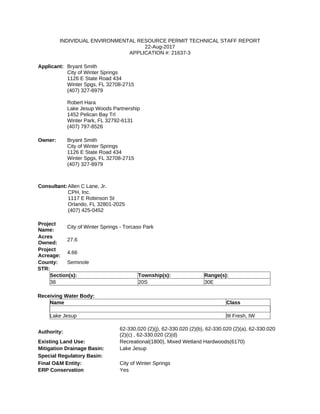
  • 1. INDIVIDUAL ENVIRONMENTAL RESOURCE PERMIT TECHNICAL STAFF REPORT 22-Aug-2017 APPLICATION #: 21637-3 Applicant: Bryant Smith City of Winter Springs 1126 E State Road 434 Winter Spgs, FL 32708-2715 (407) 327-8979 Robert Hara Lake Jesup Woods Partnership 1452 Pelican Bay Trl Winter Park, FL 32792-6131 (407) 797-8526 Owner: Bryant Smith City of Winter Springs 1126 E State Road 434 Winter Spgs, FL 32708-2715 (407) 327-8979 Consultant:Allen C Lane, Jr. CPH, Inc. 1117 E Robinson St Orlando, FL 32801-2025 (407) 425-0452 Project Name: City of Winter Springs - Torcaso Park Acres Owned: 27.6 Project Acreage: 4.66 County: Seminole STR: Section(s): Township(s): Range(s): 38 20S 30E Receiving Water Body: Name Class Lake Jesup III Fresh, IW Authority: 62-330.020 (2)(j), 62-330.020 (2)(b), 62-330.020 (2)(a), 62-330.020 (2)(c) , 62-330.020 (2)(d) Existing Land Use: Recreational(1800), Mixed Wetland Hardwoods(6170) Mitigation Drainage Basin: Lake Jesup Special Regulatory Basin: Final O&M Entity: City of Winter Springs ERP Conservation Yes
  • 2. Easements/Restrictions: Interested Parties: No Objectors: No Authorization Statement: Modification of Permit 21637-2 for City of Winter Springs - Torcaso Park, a 4.66 - acre project to be constructed and operated as per plans received by the District on July 25, 2017. Recommendation: Approval Reviewers: Ken Lewis; Gary Haddle Staff Comments Project Applicant and Sufficient Real Property Interest: Under rule 62-330.060, Florida Administrative Code (F.A.C.), and subsection 4.2.3(d), Environmental Resource Permit Applicant’s Handbook Volume I (ERP A.H. Volume I), a permit applicant must certify that it has sufficient real property interest over the land upon which the activities subject to the application will be conducted. The permit applicants are the record title holders. Project Location and Brief Description: This project is located at 104 N. Moss Road within the City of Winter Springs, Seminole County. This application seeks authorization to modify the existing Torcaso Park to construct new parking lots, drive lanes, and a new building with covered basketball courts. Demolition and reconstruction of one existing parking lot is also proposed. This application proposes 0.63 acres of direct wetland impacts, and 0.34 acres of direct surface water impacts. Permitting History: On April 9, 1984, the District issued Management and Storage of Surface Water Permit 4-117-0016G for the extension of Moss Road from State Road 434 to State Road 419 and a 10.5 acre-foot surface water management pond. Construction of this extension involved work in approximately 0.1 acres of surface waters. On November 10, 1995, the District issued Permit 40-117-0323G-ERP for construction of a 4.4-acre Public Safety Facility for the City of Winter Springs. Construction of this facility involved work in 0.30 acres of surface waters. On May 6, 2002, the District issued Permit 40-117-21637-2 for modification of an existing surface water management system, consisting of construction of a city park, parking lot with driveway, and future parking area and conveyance system. This construction authorized work in 0.53 acres of man-made surface waters. Engineering
  • 3. Description of Project (Surface Water Management System): The project site consists of an existing City park and wet detention pond, with an upland-cut drainage ditch that connects to an existing 48" stormwater pipe at Edgemon Avenue and an existing pipe on the park property. The applicant proposes to construct new parking lots, drive lanes, and a new building with covered basketball courts. The applicant also proposes demolition and reconstruction of one existing parking lot. An new entrance road and sidewalk will be constructed on fill above the drainage ditch. A new 48" pipe will replace the ditch. Stormwater runoff from all existing and proposed development will discharge/continue to discharge to the existing wet detention pond. Water Quality: The applicant has submitted plans and calculations demonstrating that the previously permitted surface water management system, modified as proposed, will continue to provide treatment and recovery of the required treatment volume for systems that discharge to a Class III waterbody. Lake Jesup is a nutrient-impaired waterbody. The existing surface water management system, modified as proposed, will continue to attenuate the post-development discharge of nutrients to at or below pre-development levels. Flood Protection: The applicant has submitted plans and calculations demonstrating that the previously permitted surface water management system, modified as proposed, will continue to provide for attenuation of the peak rate of discharge of stormwater runoff from the 25- year/24-hour storm event. Special Basin Criteria: N/A Operation and Maintenance: The permit applicants will be the operation and maintenance entity. Environmental Site Description: The project site consists of an existing City park and wet stormwater pond, including play fields, paved parking area, various pavilions, splash pad recreation area, and sidewalks. There is an onsite 0.63-acre wetland (W1), which is a low quality, forested system connected to the north via an underground culvert pipe. The wetland receives
  • 4. direct runoff from the adjacent Moss Road, and appears to have distressed hydrologic conditions as indicated by soil subsidence and treefall. The canopy consists of sweetbay magnolia, red maple, loblolly bay, slash pine, water oak, sabal palm, Chinese tallow, chinaberry, and camphor tree, along with a shrub layer of Brazilian pepper and Peruvian primrosewillow. The project also includes an onsite ditch (SW1) that is approximately 600-feet long and 25-feet wide (0.34 acre). The ditch is located on the west side of the project between the existing park and N. Edgemon Avenue and is regularly mowed and maintained. Impacts: Subsection 10.2.2, ERP A.H. Volume I, states that an applicant must provide reasonable assurances that a regulated activity will not impact the values of wetland and other surface water functions so as to cause adverse impacts to: (a) the abundance and diversity of fish, wildlife and listed species; and (b) the habitat of fish, wildlife and listed species. The proposed project will result in direct impacts to the 0.63-acre wetland W1. In addition, the 0.34-acre surface water (SW1) will be impacted. Pursuant to 10.2.2.2, ERP A.H. Volume I, any drainage ditches that were constructed in uplands will not be required to comply with provisions of subsections 10.2.2-10.2.2.3, 10.2.3-10.2.3.7, 10.2.5-10.3.8., ERP A.H. Volume I. This drainage ditch does not provide significant habitat for threatened or endangered species, and the impacts are not considered adverse. Therefore, no elimination or reduction, mitigation or cumulative impacts analysis will be required for the dredge and fill activities proposed within the drainage ditch (SW1). Secondary impacts: Subsection 10.2.7, ERP A.H. Volume I, contains a four-part criterion that addresses additional impacts that may be caused by a proposed activity: (a)adverse impacts to wetland (and other surface water) functions and water quality violations that may result from the intended or reasonably expected uses of a proposed activity; (b) adverse impacts to the upland nesting habitat of bald eagles and aquatic or wetland dependent listed animal species; (c) impacts to significant historical and archaeological resources that are very closely linked and causally related to any proposed dredging or filling of wetlands or other surface waters; and (d) adverse wetland (and other surface) impacts and water quality violations that may be caused by future phases of the project or by activities that are very closely linked and causally related to the project. a.) The project is sufficiently distant from offsite wetlands and other surface waters to ensure that the project will not cause unacceptable adverse secondary impacts to their functions. The offsite forested wetland that is located north of the onsite ditch to be filled is a minimum of 25 feet away from the proposed construction. The offsite wetland is located on City-owned property, and a note on the plans was added which labels the offsite wetlands and uplands as "Conservation Area No Vegetation Disturbance or Dumping Allowed", which will ensure that no secondary impacts will occur within this area.
  • 5. b.) No listed species are likely to reproduce in uplands near the present project that could be diminished by the work or future land use. c.) No adverse, unacceptable impacts to archaeological or historical resources are anticipated to result from this proposed project, pursuant to Section 10.2.7(d), ERP A.H. Volume I. d.) The present project will be authorized entirely by this ERP. Future phases that may occur will have sufficient uplands available to achieve the project without the need to impact in additional adverse impacts. Elimination/Reduction of Impacts: Pursuant to Subsection 10.2.1.1, ERP A.H. Volume I, the applicant must implement practicable design modifications to reduce or eliminate adverse impacts to wetlands and other surface waters. A proposed modification that is not technically capable of being completed, is not economically viable, or that adversely affects public safety through endangerment of lives or property is not considered "practicable". Alternatively, an applicant may meet this criterion by demonstrating compliance with subsection 10.2.1.2.a. or 10.2.1.2.b, ERP A.H. Volume I. Elimination or reduction of impacts was not required for the 0.63-acre direct impacts to W1 because the ecological value of the functions provided by the area of wetland to be adversely affected is low, and the proposed mitigation will provide greater long term ecological value than the area of wetland to be adversely affected, pursuant to Section 10.2.1.2(a.) ERP A.H. Volume I. Mitigation: As mitigation for the 0.63 acres of adverse direct impacts to W1, the applicant is proposing to preserve 2.50 acres of wetlands at the Jesup Station Mitigation Tract. These 2.50 acres of wetlands will be recorded in a conservation easement dedicated to the District. This 2.50 acre tract will be located within a portion of the 60.3-acre Jesup Station Mitigation Tract that Lake Jesup Woods Partnership plans on preserving for future projects/ impacts. The Jesup Station Mitigation Tract (Mitigation Tract) is located in Seminole County, east of Design Court and along the southern side of the Seaboard Coastline Railroad right- of-way in Sanford. The Mitigation Tract is located along the northwestern side of Lake Jesup. The Mitigation Tract is connected to undeveloped floodplain forest to the southeast that borders Lake Jesup, some residential development is located to the east and west of the Mitigation Tract, and the railroad and undeveloped land are located north of the Mitigation Tract. The Mitigation Tract is comprised of 15.5 acres of a temperate hardwood upland community, and 44.8 acres of a wetland forested mixed community. The upland community provides habitat support to the adjacent wetlands. The upland and wetland
  • 6. communities are high quality communities with a majority of appropriate and desirable plant species located within each stratum, and minimal cover of invasive exotic or other invasive plant species. The proposed Preservation and Management Plan, received as Exhibit C to the draft Conservation Easement received on June 9, 2017, will ensure this area will continue to provide these high quality functions in perpetuity. The Mitigation Tract provides supporting wetland community functions by supplying food sources, nesting and denning habitat and maintains connectivity of a relatively large wetland system within the Lake Jesup Basin. Therefore, the proposed project is consistent with the wetland review criteria in Sections 10.2 - 10.3.8, ERP A.H. The proposed mitigation will offset the same ecological functions as the wetland to be impacted, because the proposed mitigation site will provide similar habitat to the wetlands that will be impacted by this project. The Lake Jesup Mitigation Tract preservation area was assessed utilizing the Uniform Mitigation Assessment Method (UMAM), pursuant to Chapter 62-345, F.A.C. Financial Assurance Mechanism: No Off-Site Mitigation: As mitigation for the 0.63 acres of adverse direct impacts associated with this project, the applicant is proposing to preserve 2.50 acres of wetlands at the Jesup Station Mitigation Tract. The 2.50 acre of wetlands will be recorded in a conservation easement dedicated to the District. Cumulative Impacts:Subsection 10.2.8, ERP A.H. Volume I, requires applicants to provide reasonable assurances that their projects will not cause unacceptable cumulative impacts upon wetlands and other surface waters within the same drainage basin as the project for which a permit is sought. This analysis considers past, present, and likely future similar impacts and assumes that reasonably expected future applications with like impacts will be sought, thus necessitating equitable distribution of acceptable impacts among future applications. Under section 10.2.8, ERP A.H. Volume, when an applicant proposes mitigation that offsets a project’s adverse impacts within the same basin as the impacts, the project does not cause unacceptable cumulative impacts. Considering the proposed mitigation plan is located within the Lake Jesup drainage basin and fully offsets the adverse impacts proposed to wetland functions within the Lake Jesup Drainage Basin, there will be no unacceptable cumulative impacts, pursuant to Section 10.2.8, ERP A.H. Volume I. Wetland Summary Table City of Winter Springs - Torcaso Park Governmental/Institutional
  • 7. Total Surface Water, Upland RHPZ and Wetlands in Project Acres Wetlands 0.630 OSW 0.340 Upland RHPZ 0.000 Total 0.970 Impacts that Require Mitigation Dredged or Filled 0.630 Total 0.630 Impacts that Require No Mitigation Dredged or Filled 0.340 Total 0.340 Mitigation On-Site Total 0.000 Off-Site Wetland Preservation 2.500 Total 2.500 Conclusion: The applicant has provided reasonable assurance that the proposed project meets the conditions for issuance of permits specified in rules 62-330.301 and 62-330.302, F.A.C. Conditions 1. All activities shall be implemented following the plans, specifications and performance criteria approved by this permit. Any deviations must be authorized in a permit modification in accordance with Rule 62-330.315, F.A.C. Any deviations that are not so authorized may subject the permittee to enforcement action and revocation of the permit under Chapter 373, F.S. 2. A complete copy of this permit shall be kept at the work site of the permitted activity during the construction phase, and shall be available for review at the work site upon request by the District staff. The permittee shall require the contractor to review the complete permit prior to beginning construction. 3. Activities shall be conducted in a manner that does not cause or contribute to violations of state water quality standards. Performance-based erosion and sediment control best management practices shall be installed immediately prior to, and be maintained during and after construction as needed, to prevent
  • 8. adverse impacts to the water resources and adjacent lands. Such practices shall be in accordance with the State of Florida Erosion and Sediment Control Designer and Reviewer Manual (Florida Department of Environmental Protection and Florida Department of Transportation June 2007), and the Florida Stormwater Erosion and Sedimentation Control Inspector’s Manual (Florida Department of Environmental Protection, Nonpoint Source Management Section, Tallahassee, Florida, July 2008), which are both incorporated by reference in subparagraph 62-330.050(9)(b)5, F.A.C., unless a project-specific erosion and sediment control plan is approved or other water quality control measures are required as part of the permit. 4. At least 48 hours prior to beginning the authorized activities, the permittee shall submit to the District a fully executed Form 62-330.350(1), “Construction Commencement Notice,”[10-1-13], incorporated by reference herein (http://www.flrules.org/Gateway/reference.asp?No=Ref-02505), indicating the expected start and completion dates. A copy of this form may be obtained from the District, as described in subsection 62-330.010(5), F.A.C. If available, a District website that fulfills this notification requirement may be used in lieu of the form. 5. Unless the permit is transferred under Rule 62-330.340, F.A.C., or transferred to an operating entity under Rule 62-330.310, F.A.C., the permittee is liable to comply with the plans, terms and conditions of the permit for the life of the project or activity. 6. Within 30 days after completing construction of the entire project, or any independent portion of the project, the permittee shall provide the following to the Agency, as applicable: a. For an individual, private single-family residential dwelling unit, duplex, triplex, or quadruplex — “Construction Completion and Inspection Certification for Activities Associated With a Private Single-Family Dwelling Unit” [Form 62-330.310(3)]; or b. For all other activities — “As-Built Certification and Request for Conversion to Operational Phase” [Form 62-330.310(1)]. c. If available, an Agency website that fulfills this certification requirement may be used in lieu of the form. 7. If the final operation and maintenance entity is a third party: a. Prior to sales of any lot or unit served by the activity and within one year of permit issuance, or within 30 days of as-built certification, whichever comes first, the permittee shall submit, as applicable, a copy of the operation and maintenance documents (see sections 12.3 thru 12.3.3 of Volume I) as
  • 9. filed with the Department of State, Division of Corporations and a copy of any easement, plat, or deed restriction needed to operate or maintain the project, as recorded with the Clerk of the Court in the County in which the activity is located. b. Within 30 days of submittal of the as- built certification, the permittee shall submit “Request for Transfer of Environmental Resource Permit to the Perpetual Operation Entity” [Form 62-330.310(2)] to transfer the permit to the operation and maintenance entity, along with the documentation requested in the form. If available, an Agency website that fulfills this transfer requirement may be used in lieu of the form. 8. The permittee shall notify the District in writing of changes required by any other regulatory District that require changes to the permitted activity, and any required modification of this permit must be obtained prior to implementing the changes. 9. This permit does not: a. Convey to the permittee any property rights or privileges, or any other rights or privileges other than those specified herein or in Chapter 62-330, F.A.C.; b. Convey to the permittee or create in the permittee any interest in real property; c. Relieve the permittee from the need to obtain and comply with any other required federal, state, and local authorization, law, rule, or ordinance; or d. Authorize any entrance upon or work on property that is not owned, held in easement, or controlled by the permittee. 10.Prior to conducting any activities on state-owned submerged lands or other lands of the state, title to which is vested in the Board of Trustees of the Internal Improvement Trust Fund, the permittee must receive all necessary approvals and authorizations under Chapters 253 and 258, F.S. Written authorization that requires formal execution by the Board of Trustees of the Internal Improvement Trust Fund shall not be considered received until it has been fully executed. 11.The permittee shall hold and save the District harmless from any and all damages, claims, or liabilities that may arise by reason of the construction, alteration, operation, maintenance, removal, abandonment or use of any project authorized by the permit. 12.The permittee shall notify the District in writing:
  • 10. a. Immediately if any previously submitted information is discovered to be inaccurate; and b. Within 30 days of any conveyance or division of ownership or control of the property or the system, other than conveyance via a long-term lease, and the new owner shall request transfer of the permit in accordance with Rule 62-330.340, F.A.C. This does not apply to the sale of lots or units in residential or commercial subdivisions or condominiums where the stormwater management system has been completed and converted to the operation phase. 13.Upon reasonable notice to the permittee, District staff with proper identification shall have permission to enter, inspect, sample and test the project or activities to ensure conformity with the plans and specifications authorized in the permit. 14.If any prehistoric or historic artifacts, such as pottery or ceramics, stone tools or metal implements, dugout canoes, or any other physical remains that could be associated with Native American cultures, or early colonial or American settlement are encountered at any time within the project site area, work involving subsurface disturbance in the immediate vicinity of such discoveries shall cease. The permittee or other designee shall contact the Florida Department of State, Division of Historical Resources, Compliance and Review Section, at (850) 245-6333 or (800) 847-7278, as well as the appropriate permitting agency office. Such subsurface work shall not resume without verbal or written authorization from the Division of Historical Resources. If unmarked human remains are encountered, all work shall stop immediately and notification shall be provided in accordance with Section 872.05, F.S. 15.Any delineation of the extent of a wetland or other surface water submitted as part of the permit application, including plans or other supporting documentation, shall not be considered binding unless a specific condition of this permit or a formal determination under Rule 62-330.201, F.A.C., provides otherwise. 16.The permittee shall provide routine maintenance of all components of the stormwater management system to remove trapped sediments and debris. Removed materials shall be disposed of in a landfill or other uplands in a manner that does not require a permit under Chapter 62-330, F.A.C., or cause violations of state water quality standards. 17.This permit is issued based on the applicant’s submitted information that reasonably demonstrates that adverse water resource-related impacts will not be caused by the completed permit activity. If any adverse impacts result, the District will require the permittee to eliminate the cause, obtain any necessary permit modification, and take any necessary corrective actions to resolve the adverse impacts.
  • 11. 18.A Recorded Notice of Environmental Resource Permit may be recorded in the county public records in accordance with Rule 62-330.090(7), F.A.C. Such notice is not an encumbrance upon the property. 19.This permit for construction will expire five years from the date of issuance. 20.At a minimum, all retention and detention storage areas must be excavated to rough grade prior to building construction or placement of impervious surface within the area to be served by those facilities. To prevent reduction in storage volume and percolation rates, all accumulated sediment must be removed from the storage area prior to final grading and stabilization. 21.The operation and maintenance entity shall inspect the stormwater or surface water management system once within two years after the completion of construction and every two years thereafter to determine if the system is functioning as designed and permitted. The operation and maintenance entity must maintain a record of each required inspection, including the date of the inspection, the name and contact information of the inspector, and whether the system was functioning as designed and permitted, and make such record available for inspection upon request by the District during normal business hours. If at any time the system is not functioning as designed and permitted, then within 30 days the entity shall submit a report electronically or in writing to the District using Form 62-330.311(1), “Operation and Maintenance Inspection Certification,” describing the remedial actions taken to resolve the failure or deviation. 22.Deed of Conservation Easement This permit requires the recording of a conservation easement. Within 30 days of recording, the permittee shall provide the District with: (a) the original recorded easement (including exhibits) showing the date it was recorded and the official records book and page number, (b) a copy of the recorded plat (if applicable), (c) a surveyor's sketch of the easement area plotted on the appropriate USGS topographic map, and (d) the original recorded consent and joinder(s) of mortgagee (if applicable). Before recording them, the permittee shall ensure that these documents are acceptable to the District as described below. Description of Conservation Easement Area. The permittee shall provide to the District for review and written approval a copy of: (a) the preliminary plat showing the area to be encumbered by the conservation easement, or (b) a surveyor's sketch and legal description of the area to be placed under the conservation easement, per the approved mitigation plan, at least 45 days before (1) dredging, filling, or clearing any wetland or surface water for which mitigation is required; (2) clearing any upland within a Riparian Habitat Protection Zone for which mitigation is required; (3) the sale of
  • 12. any lot or parcel; (4) the recording of the subdivision plat; or (5) use of the infrastructure for its intended use, whichever occurs first. If the impacts to an upland within a Riparian Habitat Protection Zone or to a wetland or surface water for which mitigation is required will occur in discrete phases, the areas to be preserved to offset such impacts may be placed under conservation easement in phases such that impacts are offset during each phase. Such phasing of preservation shall only occur if it has been proposed in the mitigation plan and approved by the permit, or if it is approved in writing by the District. A surveyor's sketch and legal description of the area to be placed under conservation easement during each phase must be submitted in accordance with the previous paragraph. Recording of Conservation Easement. Before (1) dredging, filling, or clearing any wetland or surface water for which mitigation is required, (2) clearing any upland within a Riparian Habitat Protection Zone for which mitigation is required, (3) the sale of any lot or parcel, (4) the recording of the subdivision plat, or (5) use of the infrastructure for its intended use, whichever occurs first, the permittee shall record a conservation easement. The conservation easement shall include restrictions on the real property pursuant to section 704.06, Florida Statutes, and be consistent with section 10.3.8, ERP Applicant's Handbook, Volume I(October 1, 2013) and Fla. Admin.Code R. 62-330.301(6). The conservation easement shall be in the form approved in writing by the District and, if no plat has been submitted, the easement shall include the approved legal description and surveyor's sketch. If the District does not provide written comments on the preliminary plat or surveyor's sketch and legal description within 45 days of receipt, then the permittee may record the conservation easement with the legal description and surveyor's sketch or plat reference previously submitted. If the District provides written disapproval of the preliminary plat or surveyor's sketch and legal description, the permittee shall, within ten (10) days of receipt of the disapproval, correct all errors with the conservation easement, including the preliminary plat or legal description and surveyor's sketch, and record the conservation easement. Pursuant to section 704.06, Florida Statutes, the conservation easement shall prohibit all construction, including clearing, dredging, or filling, except that which is specifically authorized by this permit, within the mitigation areas delineated on the final plans and/or mitigation proposal approved by the District. The easement may not be amended without written District approval. Additional Documents Required.
  • 13. The permittee shall ensure that the conservation easement identifies, and is executed by, the correct grantor, who must hold sufficient record title to the land encumbered by the easement. If the easement's grantor is a partnership, the partnership shall provide to the District a partnership affidavit stating that the person executing the conservation easement has the legal authority to convey an interest in the partnership land. If there exist any mortgages on the land, the permittee shall also have each mortgagee execute a consent and joinder of mortgagee subordinating the mortgage to the conservation easement. The consent and joinder of the mortgagee shall be recorded simultaneously with the conservation easement in the public records of the county where the land is located. Within 30 days of recording, the permittee shall provide the District with: (a) the original recorded easement (including exhibits) showing the date it was recorded and the official records book and page number, (b) a copy of the recorded plat (if applicable), (c) a surveyor's sketch of the easement area plotted on the appropriate USGS topographic map, and (d) the original recorded consent and joinder(s) of mortgagee (if applicable). Demarcation of Conservation Easement Area. Prior to lot or parcel sales, all changes in direction of the easement area boundaries must be permanently monumented above ground on the project site. 23.The proposed project must be constructed and operated as per plans received by the District on July 25, 2017. 24.This permit authorizes 0.63 acres of adverse direct wetland impacts and 0.34 acres of surface water impacts. 25.This permit requires the recording of 2.50 acres of wetlands into a conservation easement dedicated to the District. The preservation of wetlands will be located at the offsite mitigation parcel known as Jesup Station Mitigation Area per the information received by the District on June 9, 2017. 26.The City of Winter Springs shall be responsible for the operation of the stormwater management system. Lake Jessup Woods Partnership shall be responsible for the success of the offsite mitigation area. 27.A maintenance program shall be implemented in accordance with the Basic Management Plan for Preservation Only Jesup Station Mitigation Tract received by the District on June 9, 2017, and to be recorded with the Conservation Easement as Exhibit C, for the preserved wetland area to ensure that area meets the integrity and viability of the success criteria as permitted, including ensuring that the mitigation site is maintained in perpetuity free from invasive exotic species such that they comprise no more than 5 percent cover. In addition, the permittee shall manage the conservation areas such that exotic/nuisance plant species do not dominate any one section of those areas.
  • 14.
  • 15. 1 -
  • 16. Current w/Impact Current w/Impact Current w/Impact Current w/Impact MD Direct 1 W1 df 2 0 2 0 3 0 0.23 0.63 0.147 0.23333 0 0.233333 2 - - - - - - - - - - - 0 0 - 3 - - - - - - - - - - - 0 0 - 4 - - - - - - - - - - - 0 0 - 5 - - - - - - - - - - - 0 0 - 6 - - - - - - - - - - - 0 0 - TOTAL 0.63 0.147 w/o Mit w/Mit w/o Mit w/Mit w/o Mit w/Mit 1 W2 Jesup Station pres 6 7 8 8 6 8 0.10 1.00 1.00 0.60 0.060 2.50 0.150 2 - - - - - - - - - - - - - - - 3 - - - - - - - - - - - - - - - 4 - - - - - - - - - - - - - - - 5 - - - - - - - - - - - - - - - 6 - - - - - - - - - - - - - - - TOTAL 2.50 0.150 Acres Acres Acres 0.00 0.00 0.00 0.00 0.00 0.00 Secondary Impacts 0.00 0.00 0.00 0.00 0.00 0.00 Total Functional Loss 0.147 Total Functional Gain 0.150 Excess Mitigation 0.003 Functional Gain PAF Impact Summary Functional Loss Water Environment Mitigation Type RFG Acres Enhancement Community Structure Restoration Direct Impacts Enhancement Location and Landscape Support Acres Total Impacts Total Upland Mitigation Torcaso Park Final UMAM Community Structure Water Environment Restoration Mitigation Summary Assessment Area Impact Type Location and Landscape Support Mitigation Delta Impacts Time Lag MODIFIABLE SUMMARY TABLE Application Number: Date: IND-117-21637-3 August 1, 2017 Site/Project Name: Impact Delta Mitigation - Upland Assessment Area Mitigation - Wetland Creation Risk TOTALS Preservation Total Wetland Mitigation Preservation