
Recommended
More Related Content
Similar to Earthquake Hazards and Risk Reduction in India
Similar to Earthquake Hazards and Risk Reduction in India (20)
Recently uploaded
Recently uploaded (20)
Earthquake Hazards and Risk Reduction in India
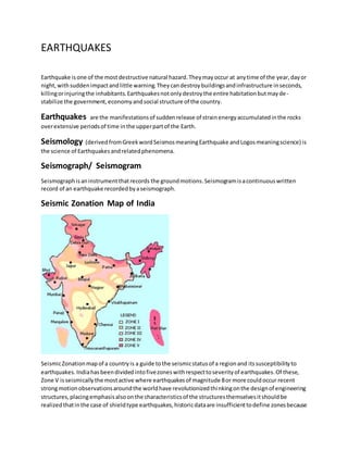
- 1. EARTHQUAKES Earthquake isone of the mostdestructive natural hazard.Theymayoccur at anytime of the year,dayor night,withsuddenimpactandlittle warning.Theycandestroybuildingsandinfrastructure inseconds, killingorinjuringthe inhabitants.Earthquakesnotonlydestroythe entire habitationbutmayde- stabilize the government,economyandsocial structure of the country. Earthquakes are the manifestationsof suddenrelease of strainenergyaccumulatedinthe rocks overextensive periodsof time inthe upperpartof the Earth. Seismology (derivedfromGreekwordSeismosmeaningEarthquake andLogosmeaningscience) is the science of Earthquakesandrelatedphenomena. Seismograph/ Seismogram Seismographisaninstrumentthatrecords the groundmotions.Seismogramisacontinuouswritten record of an earthquake recordedbyaseismograph. Seismic Zonation Map of India SeismicZonationmapof a countryis a guide tothe seismicstatusof a regionand itssusceptibilityto earthquakes. Indiahasbeendividedintofivezoneswithrespecttoseverityof earthquakes.Of these, Zone V isseismicallythe mostactive where earthquakesof magnitude 8or more couldoccur recent strongmotionobservationsaroundthe worldhave revolutionizedthinkingonthe designof engineering structures,placingemphasisalsoonthe characteristicsof the structuresthemselvesitshouldbe realizedthatinthe case of shieldtype earthquakes,historicdataare insufficienttodefine zonesbecause
- 2. recurrence intervalsare muchlongerthanthe recordedhumanhistorythismayoftengive afalse sense of security.Occurrence of the damagingearthquake atLatur,fallinginzone Iisa typical example of this situation. Cause of Earthquake : The earth’scrust is a rocky layerof varyingthicknessrangingfromadepthof about 10kilometersunder the sea to 65 kilometersunderthe continents.The crustisnotone piece butconsistsof portionscalled ‘plates’whichvaryinsize froma fewhundredtothousandsof kilometers.The ‘theoryof plate tectonics’ holdsthattheplatesride uponthe more mobile mantle,andare drivenbysome yetunconfirmed mechanisms,perhapsthermalconvectioncurrents.Whentheseplatescontacteachother,stressarises inthe crust.These stressescanbe classifiedaccordingtothe type of movementalongthe plate’s boundaries: a) pullingawayfromeachother, b) pushingagainstone anotherand c) slidingsidewaysrelativetoeachother. All these movementsare associatedwithearthquakes.The areasof stressatplate boundarieswhich release accumulatedenergybyslippingorrupturingare knownas'faults'.The theoryof 'elasticity'says that the crustiscontinuouslystressedbythe movementof the tectonicplates;iteventuallyreachesa pointof maximumsupportable strain.A rupture thenoccursalongthe faultand the rock rebounds underitsownelasticstressesuntil the strainisrelieved.The faultrupture generatesvibrationcalled seismic(fromthe Greek'seismos'meaningshockorearthquake) waves,whichradiatesfromthe focusin all directions.The pointof rupture iscalledthe 'focus'andmay be locatednearthe surface or deep belowit.The pointonthe surface directlyabove the focusistermedasthe epicenter'of the earthquake Magnitude: It isa quantitytomeasure the size of an earthquake andisindependentof the place of the observation. Richter Scale: The local magnitude isdefinedasthe logarithmof the maximumamplitude measuredinmicronsona seismogramwrittenbyWood-Andersonseismographwithfree periodof 0.8second,magnificationof 2,800, dampingfactor of 0.8 calculatedtobe at a distance of 100 kms.The relative size of eventsis calculatedbycomparisontoa reference eventof ML=0,usingthe formula,ML=log A-logAo
- 3. where A isthe maximumtrace amplitude inmicrometerrecordedonastandardseismographand Ao isa standard value whichisa functionof epicentral distance (Δ) inkilometers. Classification of earthquakes Category Magnitude on Richter Scale Slight Upto 4.9 Moderate 5.0 to 6.9 Great 7.0 to 7.9 VeryGreat 8.0 and more Indiahas witnessedsome of the mostdevastatingearthquakesduringthe lastcenturylike the one in Kangra (1905), Bihar-Nepal (1934) and inAssam(1950). In the recentpast,earthquakeshave caused havoc inUttarkashi (1991), Latur (1993), Jabalpur(1997), Chamoli (1999) and inBhuj (2001). On 26th January2001, Indiaexperiencedone of the worstearthquakes inrecenttimes.Measuring6.9 on the Richterscale,the earthquake causedincalculabledamage notjusttoitsepicenter,Bhuj butalso to othertownsof the districtof Kutchand to about 500 villagesoutof the total of 900 villages.The reporteddamage topropertyinGujarat was aboutRs.21, 000crore and the numberof humanliveslost were about14,000. Of these,more than500 deathswere reportedfromAhmedabad,situatedata distance of about350 kmsfrom Bhuj.Inthe same city,close to150 multi-storiedbuildingscrumbled down.Citiesfarawayfromthe epicenter,likeSurat,tooreporteddamage toproperty. SOME DAMAGING EARTHQUAKES IN INDIA AND APPROXIMATE NUMBER OF LIVES LOST Year of occurrence Place of occurrence Intensity Others 1618 Bombay - - 2000 lives lost 1720 Delhi 6.5 - Some lives lost 1737 Bengal - - 300,000 lives lost 1803 Mathura 6.5 - The shock felt up to Calcutta. 1803 Kumaon 6.5 - Killed 200-300 people. 1819 Kutchch 8.0 XI Chief towns of Tera, Kathara and Mothala razed to the ground. 1828 Srinagar 6.0 - 1000 people killed. 1833 Bihar 7.7 X Hundreds of people killed 1848 Mt.Abu, Rajasthan 6.0 - Few people killed 1869 Assam 7.5 - Affected an area of 2,50,000 Sq. miles. 1885 Srinagar 7.0 - Kamiarary area destroyed. 1897 Shillong 8.7 XII Wide spread destruction in Shillong. 1905 Himachal Pradesh 8.0 XI Thousands of people killed. 1906 Himachal Pradesh 7.0 - Heavy damage.
- 4. 1916 Nepal 7.5 - All houses collapsed at Dharchulla. 1918 Assam 7.6 - Heavy damage. 1930 Dhubri, Meghalaya 7.1 IX Heavy damage in Dhubri. 1934 Bihar, Nepal 8.3 XI Large number of border area people killed. 1935 Quetta (in Pakistan) 7.5 IX 25,000 people killed 1941 Andaman 8.1 X Very heavy damage. 1947 Dibrugarh 7.8 - Heavy damage. 1950 Assam 8.6 XII Heavy damage to life and property. 1952 NE India 7.5 - Heavy damage. 1956 Bulandshahar, U.P. 6.7 VIII Many people killed 1956 Anjar, Gujarat 7.0 VIII Hundreds of people killed 1958 Kapkote, U.P. 6.3 VIII Many people killed 1967 Koyna, 6.1 VIII Koyna Nagar razed. 1969 Bhadrachalam 6.5 1 Heavy damage. 1986 Dharamshala (H.P) 5.7 VIII Lots of damage. 1988 Assam 7.2 IX Few people killed 1988 Bihar- Nepal 6.5 VIII Large number of people killed. 1991 Uttarkashi 6.6 VIII Lots of damage to life and property. 1993 Latur 6.4 VIII Heavy damage to life and property about, 000 people killed. 1997 Jabalpur 6.0 VIII Lots of damage to property, about 39 lives lost. 1999 Chamoli 6.8 VIII Lots of damage to property about 100 people lost lives. 2001 Bhuj 6.9 X Huge devastation, about ~ 14000 people lost lives EARTHQUAKE HAZARDS IN INDIA
- 5. Indiahas hada longhistoryof earthquake occurrences.About65% of the total areaof the country is vulnerable toseismicdamage of buildingsin varyingdegrees.The mostvulnerable areas,accordingto the presentseismiczone mapof India,are locatedinthe Himalayanandsub-Himalayanregions,Kutch and the AndamanandNicobarIslands.Dependingonvaryingdegreesof seismcity,the entire country can be dividedintothe followingseismicregions: KashmirandWesternHimalayas - Coversthe statesof Jammu andKashmir,Himachal Pradesh and sub-mountainousareasof Punjab. Central Himalayas - Includesthe mountainandsub-mountainregionsof UttarPradeshandthe sub-mountainouspartsof Punjab. North-eastIndia- Comprisesthe wholeof Indianterritorytothe eastof northBengal. Indo-GangeticbasinandRajasthan - Thisregioncomprisesof Rajasthan,plainsof Punjab, Haryana, Uttar Pradeshand WestBengal. Cambayand Rann of Kutch. PeninsularIndia,includingthe islandsof Lakshwadeep. The Andamanand NicobarIslands. MEASURES FOR EARTHQUAKE RISK REDUCTION For betterunderstandingof all the possibilitiesof earthquakeriskreduction,itisimportanttoclassify themintermsof the role that each one of themcouldplay.Therefore,inthe pre-earthquakephase, preparedness,mitigationandpreventionare conceptstoworkon. Post-disaster,immediate rescue and relief measuresincludingtemporaryshelteringsoonafteranearthquake until about3monthslaterand re-constructionandre-habilitationmeasuresforaperiodof about six monthstothree yearsneedto follow.Toencapsulate,the mosteffectivemeasuresof riskreductionare pre-disastermitigation, preparednessandpreventive measurestoreduce vulnerabilityandexpeditious,effectiverescue and relief actionsimmediatelyafterthe occurrence of the earthquake.Dependinguponthe calamityandits consequences,strategiescanalsobe divided intolongterm(five tofifteenyears),mediumterm(one to five years) andshortterm(to be takenup immediatelyinhighriskareas).Sinceithasbeenrealizedthat earthquakesdon'tkill people butfaultyconstructedbuildingsdo,the taskof reducing vulnerabilityof structuresand buildingswillbe the keytoearthquake riskreduction.Also,pre-disasterpreparedness througha post-earthquake response plan,includingtrainingof the concernedpersonnelinvariousroles, isconsideredessentialforimmediate andeffective response afteranearthquake occurrence.The major actionpointsare highlightedinthe followingparagraphs. PRE-DISASTER PREVENTIVE MEASURES Long-termmeasures Re-framingbuildings'codes,guidelines,manualsandbyelawsandtheir strictimplementation. Tougherlegislationforhighlyseismicareas. Incorporatingearthquake resistantfeaturesinall buildingsathigh-riskareas.
- 6. Making all publicutilitieslikewatersupplysystems,communicationnetworks,electricitylines etc. earthquake-proof.Creatingalternative arrangementstoreduce damagestoinfrastructure facilities. Constructingearthquake-resistantcommunitybuildingsandbuildings(usedtogatherlarge groupsduringor afteran earthquake) like schools,dharamshalas, hospitals,prayerhalls,etc., especiallyinseismiczonesof moderate tohigherintensities. SupportingR&Din variousaspectsof disastermitigation,preparednessandpreventionand post-disastermanagement. Evolvingeducationalcurriculainarchitecture andengineeringinstitutionsandtechnical training inpolytechnicsandschoolstoinclude disasterrelatedtopics. Medium term measures Retrofittingof weakstructuresinhighlyseismiczones. Preparationof disasterrelatedliterature inlocal languageswithdosanddon'tsfor construction. Gettingcommunitiesinvolvedinthe processof disastermitigationthrougheducationand awareness. Networkingof local NGOsworkinginthe areaof disastermanagement. Earthquake Facts & Statistics Frequency of Occurrenceof Earthquakes Descriptor Magnitude Average Annually Great 8 and higher 1 ¹ Major 7 - 7.9 17 ² Strong 6 - 6.9 134 ² Moderate 5 - 5.9 1319 ² Light 4 - 4.9 13,000 (estimated) Minor 3 - 3.9 130,000 (estimated) Very Minor 2 - 2.9 1,300,000 (estimated) ¹Based on observations since 1900. ² Based on observations since 1990. Year-wisedescription of Earth Quakes Number of Earthquakes Worldwide for 2000 - 2005. Located by the US Geological Survey National Earthquake Information Center Magnitude 2000 2001 2002 2003 2004 2005 8.0 to 9.9 1 1 0 1 2 1 7.0 to 7.9 14 15 13 14 14 9 6.0 to 6.9 158 126 130 140 140 116 5.0 to 5.9 1345 1243 1218 1203 1509 1307 4.0 to 4.9 8045 8084 8584 8462 10894 10264 3.0 to 3.9 4784 6151 7005 7624 7937 5782
- 7. 2.0 to 2.9 3758 4162 6419 7727 6317 3249 1.0 to 1.9 1026 944 1137 2506 1344 20 0.1 to 0.9 5 1 10 134 103 0 No Magnitude 3120 2938 2937 3608 2939 642 Total 22256 23534 27454 31419 * 31199 * 21390 Estimated Deaths 231 21357 1685 33819 284010 1957 List of Some SignificantEarthquakes in India Date Epicenter Location Magnitude 1819 Jun 16 23.6 68.6 Kutch,Gujarat 8.0 1869 Jan 10 25 93 Near Cachar, Assam 7.5 1885 May 30 34.1 74.6 Sopor, J&K 7.0 1897 Jun 12 26 91 Shillongplateau 8.7 1905 Apr 04 32.3 76.3 Kangra, H.P 8.0 1918 Jul 08 24.5 91.0 Srimangal, Assam 7.6 1930 Jul 02 25.8 90.2 Dhubri, Assam 7.1 1934 Jan 15 26.6 86.8 Bihar-Nepalborder 8.3 1941 Jun 26 12.4 92.5 Andaman Islands 8.1 1943 Oct 23 26.8 94.0 Assam 7.2 1950 Aug 15 28.5 96.7 Arunachal Pradesh-China Border 8.5 1956 Jul 21 23.3 7.0 Anjar, Gujarat 7.0 1967 Dec 10 17.37 73.75 Koyna, Maharashtra 6.5 1975 Jan 19 32.38 78.49 Kinnaur, Hp 6.2 1988 Aug 06 25.13 95.15 Manipur-Myanmar Border 6.6 1988 Aug 21 26.72 86.63 Bihar-Nepal Border 6.4 1991 Oct 20 30.75 78.86 Uttarkashi, Up Hills 6.6 1993 Sep 30 18.07 76.62 Latur - Osmanabad, Maharashtra 6.3 1997 May 22 23.08 80.06 Jabalpur, MP 6.0 1999 Mar 29 30.41 79.42 Champoli, UP 6.8 2001 Jan 26 23.40 70.28 Bhuj, Gujarat 6.9