
Recommended
Recommended
More Related Content
Similar to SAIMM Young Professional Conference 2015 - Kwartelspan Rooikoppie Study
Similar to SAIMM Young Professional Conference 2015 - Kwartelspan Rooikoppie Study (20)
Recently uploaded
Recently uploaded (20)
SAIMM Young Professional Conference 2015 - Kwartelspan Rooikoppie Study
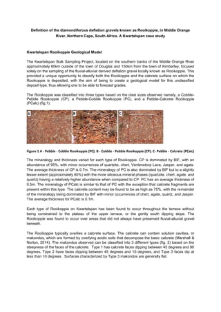
- 1. Definition of the diamondiferous deflation gravels known as Rooikoppie, in Middle Orange River, Northern Cape, South Africa. A Kwartelspan case study Kwartelspan Rooikoppie Geological Model The Kwartelspan Bulk Sampling Project, located on the southern banks of the Middle Orange River approximately 60km outside of the town of Douglas and 150km from the town of Kimberley, focused solely on the sampling of the fluvial-alluvial derived deflation gravel locally known as Rooikoppie. This provided a unique opportunity to classify both the Rooikoppie and the calcrete surface on which the Rooikoppie is deposited, with the aim of being to create a geological model for this unclassified deposit type, thus allowing one to be able to forecast grades. The Rooikoppie was classified into three types based on the clast sizes observed namely, a Cobble- Pebble Rooikoppie (CP), a Pebble-Cobble Rooikoppie (PC), and a Pebble-Calcrete Rooikoppie (PCalc) (fig.1). Figure 1 A - Pebble - Cobble Rooikoppie (PC). B - Cobble - Pebble Rooikoppie (CP). C- Pebble - Calcrete (PCalc) The mineralogy and thickness varied for each type of Rooikoppie. CP is dominated by BIF, with an abundance of 95%, with minor occurrences of quartzite, chert, Ventersdorp Lava, Jasper, and agate. The average thickness of CP is 0.7m. The mineralogy of PC is also dominated by BIF but to a slightly lesser extent (approximately 80%) with the more siliceous mineral phases (quartzite, chert, agate, and quartz) having a relatively higher abundance when compared to CP. PC has an average thickness of 0.5m. The mineralogy of PCalc is similar to that of PC with the exception that calcrete fragments are present within this type. The calcrete content may be found to be as high as 75%, with the remainder of the mineralogy being dominated by BIF with minor occurrences of chert, agate, quartz, and Jasper. The average thickness for PCalc is 0.1m. Each type of Rooikoppie on Kwartelspan has been found to occur throughout the terrace without being constrained to the plateau of the upper terrace, or the gently south dipping slope. The Rooikoppie was found to occur over areas that did not always have preserved fluvial-alluvial gravel beneath. The Rooikoppie typically overlies a calcrete surface. The calcrete can contain solution cavities, or makondos, which are formed by overlying acidic soils that decompose the basic calcrete (Marshall & Norton, 2014). The makondos observed can be classified into 3 different types (fig. 2) based on the steepness of the faces of the calcrete. Type 1 has calcrete faces dipping between 45 degrees and 90 degrees, Type 2 have faces dipping between 45 degrees and 10 degrees, and Type 3 faces dip at less than 10 degrees. Surfaces characterized by Type 3 makondos are generally flat.
- 2. Figure 2: A - Type 1 Makondos. B - Type 2 Makondos. C - Type 3 Makondos Geological mapping of the Kwartelspan Bulk Project showed that the upper most terrace, which is a plateau, consists of a PC Rooikoppie. The Rooikoppie located on the south dipping slope, although the Rooikoppie classification scheme failed to show it, contains a PC that is generally much coarse with larger Pebble clasts being observed than on the Upper Terrace. The remainder of the Rooikoppie on this slope is CP. The remainder of the Rooikoppie found on the project was PCalc. Figure 3: A - Geological Map. B - Geology vs Grades The mining of these different Rooikoppies, which had different underlying makondos, produced different grades. Only areas mined to completion (the makondos had all the Rooikoppie removed) were considered. A summary of the pits sampled, and their respective diamond data, can be found in the table 1. The grade is a function of carats recovered from each pit and the surveyed volume of material sampled each pit. Table 1 Summary of the various pits characteristics The better producing pits had two common factors. Firstly, there appears to be correlation between the increase in both grade and average stone size as CP content increases. This could be because the fluvial-alluvial material that deflated was coarser in certain portions. Coarser fluvial-alluvial gravels tend to better trap sites for larger diamonds and thus have a better diamondiferous potential. Secondly, areas that contain Type 1 makondos appear to have higher grades. This can be attributed to the colluvial movement of Rooikoppie. The Type 1 makondos, with steep sides allows entrainment of diamonds to occur as the high density of diamonds lets them settle into the makondos where the steep sides prevent further movement downslope movement. Rooikoppie hosted within Type 2 and Type 3 Makondos is prone to movement by gravity and sheet wash which can result in Rooikoppie A B EE23 DD27 DD29 EE31
- 3. being spread out over a larger area and as result can dilute grades. Although the above the data presented is limited, the trends observed should be taken into consideration as future surface mapping and pitting takes place. References Marshall, T.R. & Norton, G.A., 2014, Technical Report on Saxendrift Alluvial Diamond Mine (Incorporating the Saxendrift, Brakfontein, Kwartelspan and Kransfontein Properties), Hay District, Republic of South Africa for Rockwell Diamonds INC. NI 43-101 Technical Report.