Recommended

Recommended
More Related Content
Similar to GeoCongress 2023 - Classifcation of Rooikoppie Gravels: Wouterspan Case Study
Similar to GeoCongress 2023 - Classifcation of Rooikoppie Gravels: Wouterspan Case Study (20)
Recently uploaded
Recently uploaded (20)
GeoCongress 2023 - Classifcation of Rooikoppie Gravels: Wouterspan Case Study
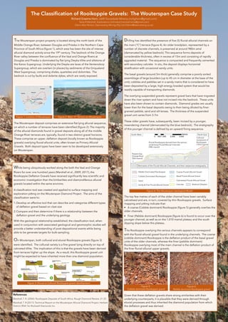
- 1. The Classification of Rooikoppie Gravels: The Wouterspan Case Study Richard Graeme Horn, UARI Sociedade Mineira (richghorn@gmail.com) Tania R Marshall, Explorations Unlimited (marshall.tania@gmail.com) Glenn Alan Norton, Daemaneng Mining (Pty) Ltd (Glenn@daemaneng.co.za) The Wouterspan project property is located along the north bank of the Middle Orange River, between Douglas and Prieska in the Northern Cape Province of South Africa (figure 1), which area has been the site of intense alluvial diamond activity since the 19th century. The bedrock of the Orange River valley between the confluence of the Vaal and Orange Rivers at Douglas and Prieska is dominated by flat-lying Dwyka tillite and siltstone of the Karoo Supergroup. Underlying the Dwyka are lavas of the Ventersdorp Supergroup, which are overlain (in places) by sediments of the Griqualand West Supergroup, comprising shales, quartzites and dolomites. The bedrock is cut by faults and dolerite dykes, which are rarely exposed. The Wouterspan deposit comprises an extensive flat lying alluvial sequence, on which a number of terraces have been identified (figure 2). The majority of the alluvial diamonds found in gravel deposits along all of the middle Orange River terraces are, typically, found in two distinct gravel horizons. These comprise an upper, deflation deposit (locally known as Rooikoppie gravels) overlying fluvial-alluvial units, often known as Primary Alluvial Gravels. Both deposit types have been seen to be developed extensively on Wouterspan. Drilling has identified the presence of five (5) fluvial-alluvial channels on the main (“C”) terrace (figure 4). An older braidplain, represented by a number of discrete channels, is preserved at around 980m amsl (demarcated by yellow bedrock). This sequence forms deposits of considerable thickness, often in excess of 15m and consisting of rapidly aggraded material. The sequence is compacted and frequently cemented with secondary calcrete. In situ, the deposit displays horizontal stratification with occasional sandy units. The basal gravels (around 5m thick) generally comprise a poorly sorted assemblage of large boulders (up to 45 cm in diameter at the base of the unit), cobbles and pebbles set in a sandy matrix that is considered to have been deposited by a large, high-energy braided system that would be readily capable of transporting diamonds. The overlying suspended gravels represent gravel bars that have migrated down the river system and have not incised into the bedrock. These units have also been shown to contain diamonds. Diamond grades are usually lower than for the basal deposits owing to their being diluted by finer- grained pebble, sand and silt lenses. The thickness of the suspended gravel unit varies from 3-7m These older gravels have, subsequently, been incised by a younger, meandering channel (demarcated by the blue bedrock). The stratigraphy of this younger channel is defined by an upward fining sequence. The top few metres of each of the older channel have been variably calcretised and are, in turn, covered by thin Rooikoppie gravels. Surface mapping and pitting indicate that: • A coarse (Cobble dominant) Rooikoppie (figure 5) generally overlies the older channels. • Finer (Pebble dominant) Rooikoppie (figure 6) is found to occur over the younger channel, as well as on the 1,010 mamsl plateau and the south dipping slope below this plateau. The Rooikoppie overlying the various channels appears to correspond with the fluvial-alluvial gravel found in the underlying channels. The coarse (cobble dominant) Rooikoppie is the deflation product of the basal gravel units of the older channels, whereas the finer (pebble dominant) Rooikoppie overlying most of the main channel is the deflation product of the finer fluvial-alluvial upper gravels. Given that these deflation gravels share strong similarities with their underlying counterparts, it is plausible that they were derived through eluvial processes and thus inherited the diamond population from which the deflation gravel was derived. While being ubiquitously worked along the both the Vaal and Orange Rivers for over one hundred years (Marshall et al., 2009; 2017), the Rooikoppie Deflation Gravels have received significantly less scientific and economic investigation than the kimberlites and diamondiferous alluvial gravels located within the same environs. A classification tool was created and applied to surface mapping and exploration pitting on the Wouterspan Diamond Project . The aims of the classification were to: 1.Develop an effective tool that can describe and categorise different types of deflation gravel based on clast size 2.Compare and then determine if there is a relationship between the deflation gravel and the underlying geology With the geological relationship established, the classification tool, when used in conjunction with associated geological and geomorphic studies will provide a better understanding of post-depositional events while being able to be generate targets for bulk-sampling. On Wouterspan, both colluvial and eluvial Rooikoppie gravels (figure 3) were identified. The colluvial variety is a fine gravel lying directly on top of calcreted tillite. The implication of this is that the gravels have been derived from terraces higher up the slope. As a result, this Rooikoppie gravel unit might be expected to have inherited more than one diamond population. Figure 5: Cobble dominant Rooikoppie gravel Figure 3: Eluvial vs Colluvial Rooikoppie gravel development References Marshall, T. R. (2004): Rooikoppie Deposits of South Africa. Rough Diamond Review, 21-25. Marshall, T. R (2017): Technical Report on the Wouterspan Alluvial Diamond Project, Herbert District, RSA”, for Rockwell Diamonds Inc. Figure 4: The Wouterspan Geological Model Figure 1: Location of Wouterspan Figure 2: Main “C” Terrace on Wouterspan Figure 6: Pebble dominant Rooikoppie gravel - Pebble Dominated Rooikoppie - Cobble Dominated Rooikoppie - Sandy & Fine Fluvial-Alluvial Gravel - Sand - Coarse Fluvial-Alluvial Gravel - Basal Fluvial-Alluvial Gravel - Calcretized Fluvial-Alluvial Gravel - Calcrete Present Day Orange River (960 mamsl) Eluvial Rooikoppie derived from the various underlying Fluvial/Alluvial Channels (980 mamsl) Remnants of the Fluvial-Alluvial Channels, and their respective stratigraphy. South-West North-East Colluvial movement of Rooikoppie (1010 mamsl) - Bedrock (Dwyka) 0 1,000 2,000 3,000 500 Metres